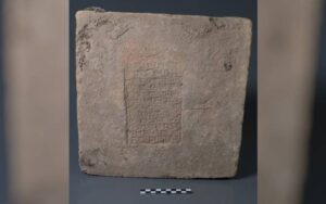
Brick dates to the reign of Nebuchadnezzar II (ca. 604 to 562 BCE) based on the interpretation of the inscription. This object was looted from its original context before being acquired by the Slemani Museum and stored in that museum with agreement from the central government. Image courtesy of the Slemani Museum
Ancient bricks inscribed with the names of Mesopotamian kings have yielded important insights into a mysterious anomaly in Earth’s magnetic field 3,000 years ago, according to a new study involving UCL researchers.
The research, published in the Proceedings of the National Academy of Sciences (PNAS), describes how changes in the Earth’s magnetic field imprinted on iron oxide grains within ancient clay bricks, and how scientists were able to reconstruct these changes from the names of the kings inscribed on the bricks.
The team hopes that using this “archaeomagnetism,” which looks for signatures of the Earth’s magnetic field in archaeological items, will improve the history of Earth’s magnetic field, and can help better date artefacts that they previously couldn’t.
Co-author Professor Mark Altaweel (UCL Institute of Archaeology) said: “We often depend on dating methods such as radiocarbon dates to get a sense of chronology in ancient Mesopotamia. However, some of the most common cultural remains, such as bricks and ceramics, cannot typically be easily dated because they don’t contain organic material. This work now helps create an important dating baseline that allows others to benefit from absolute dating using archaeomagnetism.”
The Earth’s magnetic field weakens and strengthens over time, changes which imprint a distinct signature on hot minerals that are sensitive to the magnetic field.
The team analysed the latent magnetic signature in grains of iron oxide minerals embedded in 32 clay bricks originating from archaeological sites throughout Mesopotamia, which now overlaps with modern day Iraq.
The strength of the planet’s magnetic field was imprinted upon the minerals when they were first fired by the brickmakers thousands of years ago.
At the time they were made, each brick was inscribed with the name of the reigning king which archaeologists have dated to a range of likely timespans.
Together, the imprinted name and the measured magnetic strength of the iron oxide grains offered a historical map of the changes to the strength of the Earth’s magnetic field.
The researchers were able to confirm the existence of the “Levantine Iron Age geomagnetic Anomaly,” a period when Earth’s magnetic field was unusually strong around modern Iraq between about 1050 to 550 BCE for unclear reasons.
Evidence of the anomaly has been detected as far away as China, Bulgaria and the Azores, but data from within the southern part of the Middle East itself had been sparse.
Lead author Professor Matthew Howland of Wichita State University said: “By comparing ancient artefacts to what we know about ancient conditions of the magnetic field, we can estimate the dates of any artifacts that were heated up in ancient times.”
To measure the iron oxide grains, the team carefully chipped tiny fragments from broken faces of the bricks and used a magnetometer to precisely measure the fragments.
By mapping out the changes in Earth’s magnetic field over time, this data also offers archaeologists a new tool to help date some ancient artefacts.
The magnetic strength of iron oxide grains embedded within fired items can be measured and then matched up to the known strengths of Earth’s historic magnetic field.
The reigns of kings lasted from years to decades, which offers better resolution than radiocarbon dating which only pinpoints an artefact’s date to within a few hundred years.
An additional benefit of the archaeomagnetic dating of the artefacts is it can help historians more precisely pinpoint the reigns of some of the ancient kings that have been somewhat ambiguous.
Though the length and order of their reigns is well known, there has been disagreement within the archaeological community about the precise years they took the throne resulting from incomplete historical records.
The researchers found that their technique lined up with an understanding of the kings’ reigns known to archaeologists as the “Low Chronology.”
The team also found that in five of their samples, taken during the reign of Nebuchadnezzar II from 604 to 562 BCE, the Earth’s magnetic field seemed to change dramatically over a relatively short period of time, adding evidence to the hypothesis that rapid spikes in intensity are possible.
Co-author Professor Lisa Tauxe of the Scripps Institution of Oceanography (US) said: “The geomagnetic field is one of the most enigmatic phenomena in earth sciences. The well-dated archaeological remains of the rich Mesopotamian cultures, especially bricks inscribed with names of specific kings, provide an unprecedented opportunity to study changes in the field strength in high time resolution, tracking changes that occurred over several decades or even less.”
The research was carried out with funding from the U.S.-Israel Binational Science Foundation.
Reference:
Matthew D. Howland, Lisa Tauxe, Shai Gordin, Mark Altaweel, Brendan Cych, Erez Ben-Yosef. Exploring geomagnetic variations in ancient mesopotamia: Archaeomagnetic study of inscribed bricks from the 3rd–1st millennia BCE. Proceedings of the National Academy of Sciences, 2023; 120 (52) DOI: 10.1073/pnas.2313361120
When our Sun was a young star, 4.56 billion years ago, what is now our solar system was just a disk of rocky dust and gas. Over tens of millions of years, tiny pebbles of dust coalesced, like a snowball rolling larger and larger, to become kilometer-sized “planetesimals” — the building blocks of Earth and the other inner planets.
Researchers have long tried to understand the ancient environments in which these planetesimals formed.
For example, water is now abundant on Earth, but has it always been?
In other words, did the planetesimals that accreted into our planet contain water?
Now, a new study combines meteorite data with thermodynamic modeling and determines that the earliest inner solar system planetesimals must have formed in the presence of water, challenging current astrophysical models of the early solar system.
The research was conducted in the laboratory of Paul Asimow (MS ’93, PhD ’97), Eleanor and John R. McMillan Professor of Geology and Geochemistry and appears in the journal Nature Astronomy on January 9.
Researchers have samples of the earliest years of the solar system in the form of iron meteorites.
These meteorites are the remnants of the metallic cores of the earliest planetesimals in our solar system that avoided accretion into a forming planet and instead orbited around the solar system before ultimately falling onto our planet.
The chemical compositions of meteorites such as these can reveal information about the environments in which they formed and answer questions such as whether the building blocks of Earth formed far from our Sun, where cooler temperatures allowed the existence of water ice, or if they instead formed closer to the Sun, where the heat would have evaporated any water and resulted in dry planetesimals.
If the latter is correct, then Earth would have formed dry and gained its water through some other method later in its evolution.
Though the meteorites themselves do not contain any water, scientists can infer its long-lost presence by examining its impact on other chemical elements.
Water is composed of two hydrogen atoms and one oxygen atom.
In the presence of other elements, water will often transfer its oxygen atom away in a process called oxidation.
For example, iron metal (Fe) reacts with water (H2O) to form iron oxide (FeO). A sufficient excess of water can drive the process further, producing Fe2O3 and FeO(OH), the ingredients of rust.
Mars, for example, is covered in rusty iron oxide, providing strong evidence that the Red Planet once had water.
Damanveer Grewal, a former Caltech postdoctoral scholar and first author of the new study, specializes in using chemical signatures from iron meteorites to gather information about the early solar system.
Though any iron oxide from the earliest planetesimals is now long gone, the team could determine how much iron would have been oxidized by examining the metallic nickel, cobalt, and iron contents of these meteorites.
These three elements should be present in roughly equal ratios relative to other primitive materials, so if any iron was “missing,” this would imply that the iron had been oxidized.
“Iron meteorites have been somewhat neglected by the planet-formation community, but they constitute rich stores of information about the earliest period of solar system history, once you work out how to read the signals,” says Asimow.
“The difference between what we measured in the inner solar system meteorites and what we expected implies an oxygen activity about 10,000 times higher.”
The researchers found that those iron meteorites thought to be derived from the inner solar system had about the same amount of missing iron metal as meteorites derived from the outer solar system.
For this to be the case, the planetesimals from both groups of meteorites must have formed in a part of the solar system where water was present, implying that the building blocks of planets accreted water right from the beginning.
The signatures of water in these planetesimals challenge many of the current astrophysical models of the solar system.
If planetesimals formed at Earth’s current orbital position, water would have existed only if the inner solar system was much cooler than models currently predict.
Alternatively, they may have formed further out, where it was cooler, and migrated in.
“If water was present in the early building blocks of our planet, other important elements like carbon and nitrogen were likely present as well,” says Grewal.
“The ingredients for life may have been present in the seeds of rocky planets right from the start.”
“However, the method only detects water that was used up in oxidizing iron,” adds Asimow.
“It is not sensitive to excess water that might go on to form the ocean. So, the conclusions of this study are consistent with Earth accretion models that call for late addition of even more water-rich material.”
The paper is titled “Accretion of the earliest inner solar system planetesimals beyond the water-snowline.” In addition to Asimow and Grewal, co-authors are former Caltech postdoctoral scholar Nicole X. Nie, Bidong Zhang of UCLA, and Andre Izidoro of Rice University. Grewal is currently an assistant professor at Arizona State University. Funding was provided by a Barr Foundation Postdoctoral Fellowship and NASA.
Reference:
Damanveer S. Grewal, Nicole X. Nie, Bidong Zhang, Andre Izidoro, Paul D. Asimow. Accretion of the earliest inner Solar System planetesimals beyond the water snowline. Nature Astronomy, 2024; DOI: 10.1038/s41550-023-02172-w
Note: The above post is reprinted from materials provided by California Institute of Technology. Original written by Lori Dajose.
Rare Earth Minerals: Unveiling the Hidden Elements of Modern Innovation
Rare earth minerals are a group of seventeen chemical elements that share unique properties making them vital components in a wide range of modern technologies. Despite the name, these elements are not particularly rare in the Earth’s crust, but they are often found in dispersed and complex geological formations, making their extraction challenging. These elements are essential in various industrial applications due to their magnetic, luminescent, and catalytic properties.
The group of rare earth minerals consists of the following elements:
Scandium (Sc) and Yttrium (Y):
While not lanthanides, scandium and yttrium are often included in discussions of rare earth minerals due to similar properties and co-occurrence in mineral deposits.
These rare earth minerals play a crucial role in various high-tech industries, including electronics, telecommunications, renewable energy, healthcare, and defense. Some key applications include:
Magnets: Neodymium, dysprosium, and praseodymium are critical for manufacturing powerful magnets used in electric vehicles, wind turbines, and various electronic devices.
Catalysts: Cerium, lanthanum, and other rare earth elements are utilized in catalysts for petroleum refining, automotive catalytic converters, and industrial processes.
Phosphors: Europium, terbium, and yttrium are essential for creating phosphors used in lighting technologies, such as LED and fluorescent lights, as well as in display screens.
Medical Imaging: Gadolinium is employed as a contrast agent in magnetic resonance imaging (MRI) for improved visibility of internal body structures.
Clean Energy Technologies: Rare earth elements are crucial for the development of clean energy technologies, including wind turbines, electric vehicles, and solar panels.
The geopolitical significance of rare earth minerals cannot be understated. A majority of the world’s rare earth production comes from China, leading to concerns about supply chain security and dependence on a single source.
So, what are the Top 10 Rare Earth Minerals in 2023?
Here are some notable rare earth minerals as of 2023:
Neodymium (Nd):
Neodymium, with the atomic number 60 and chemical symbol Nd, is a key player in the fascinating realm of rare earth minerals. This versatile element has become synonymous with the production of high-performance magnets, revolutionizing various industries and technologies. Let’s delve into the captivating world of neodymium, exploring its properties, applications, and significance in the 21st century.
Properties of Neodymium:
Magnetic Powerhouse:
Neodymium is renowned for its exceptional magnetic properties. When combined with iron and boron, it forms neodymium-iron-boron magnets, which are the strongest permanent magnets known.
Lustrous and Silvery:
In its pure form, neodymium is a shiny, silvery metal that quickly tarnishes in air. It belongs to the lanthanide series and is part of the rare earth elements.
High Melting Point:
Neodymium boasts a relatively high melting point, enhancing its suitability for applications involving high temperatures, such as in electric motors.
Applications of Neodymium:
Magnets for Modern Technologies:
– The primary and most celebrated application of neodymium is in the production of strong, lightweight magnets. These magnets are integral in a plethora of modern technologies, including:
– Electric Vehicles (EVs): Neodymium magnets power the electric motors in EVs, contributing to their efficiency and compact design.
– Wind Turbines: Neodymium magnets are crucial components in the generators of wind turbines, enhancing energy conversion.
– Consumer Electronics: From headphones to hard drives, neodymium magnets are ubiquitous in various consumer electronics.
Lasers and Lighting:
Neodymium is used in lasers for materials processing, medical applications, and communication. Additionally, neodymium compounds are employed in certain types of glass to produce vibrant colors, enhancing the quality of camera lenses and other optical devices.
Catalysts:
Neodymium finds applications in catalytic converters for automobiles, contributing to the reduction of harmful emissions by facilitating more efficient combustion.
Nuclear Reactor Control Rods:
Neodymium is used in nuclear reactors as part of control rods, helping regulate the fission reaction.
Significance in Technology and Industry:
Miniaturization of Devices:
The powerful yet compact nature of neodymium magnets has played a pivotal role in the miniaturization of electronic devices, making them smaller, lighter, and more portable.
Green Technologies:
Neodymium’s role in electric vehicles and wind turbines aligns with global efforts to transition towards sustainable and green technologies, contributing to a cleaner and more energy-efficient future.
Challenges and Considerations:
The dependence on neodymium raises concerns about supply chain vulnerabilities, as a significant portion of its production is concentrated in a few regions, primarily China. Efforts are underway to diversify sources and explore recycling solutions to address these challenges.
Dysprosium (Dy):
Dysprosium, with the atomic number 66 and chemical symbol Dy, takes center stage as a vital and strategic element within the fascinating realm of rare earth minerals. Let’s embark on a journey to unravel the unique properties, applications, and the critical role dysprosium plays in shaping the landscape of modern technologies and clean energy solutions.
Properties of Dysprosium:
Magnetic Characteristics:
Dysprosium exhibits powerful magnetic properties, making it a sought-after component in the creation of specialized magnets.
High Melting Point:
Like other rare earth elements, dysprosium possesses a relatively high melting point, allowing it to withstand elevated temperatures without losing its magnetic properties.
Radioactive Isotopes:
Dysprosium has several radioactive isotopes, but its most commonly used form (Dy-164) is stable and non-radioactive.
Applications: Dysprosium is crucial for the production of neodymium-iron-boron magnets, particularly in applications requiring high-temperature stability, such as in electric vehicles and renewable energy technologies.
Terbium (Tb):
Terbium, adorned with the atomic number 65 and the chemical symbol Tb, stands as a remarkable and indispensable element within the realm of rare earth minerals. This versatile element plays a crucial role in various technologies, particularly in the realms of lighting, electronics, and green energy solutions. Let’s delve into the unique properties, applications, and the illuminating impact that terbium has on the modern world.
Properties of Terbium:
Luminescent Brilliance:
Terbium possesses exceptional luminescent properties, making it a key component in phosphors used in various lighting technologies.
Magnetic Characteristics:
Terbium exhibits magnetic properties, and it is often utilized in the creation of specialized magnets.
Applications: Terbium is used in the production of phosphors for color television tubes, fluorescent lamps, and LED lighting. It is also important in certain electronic devices and medical imaging.
Europium (Eu):
Europium, with the atomic number 63 and chemical symbol Eu, takes center stage as a captivating element within the family of rare earth minerals. Renowned for its luminescent properties, europium plays a crucial role in the creation of vibrant and energy-efficient lighting technologies, as well as other electronic applications. Let’s explore the unique properties, applications, and the illuminating impact that europium brings to the forefront of modern technology.
Properties of Europium:
Luminescent Brilliance:
Europium is renowned for its unique luminescent properties, particularly in the red and blue spectral regions. This makes it a valuable component in the creation of phosphors for various lighting applications.
Paramagnetic Nature:
Europium exhibits paramagnetic properties, making it suitable for certain magnetic applications.
Applications: Europium is a key component in phosphors for color television tubes and LED lighting. It plays a vital role in producing red and blue colors in displays and lighting technologies.
Yttrium (Y):
Yttrium, denoted by the atomic number 39 and chemical symbol Y, stands as a versatile and essential element within the rare earth mineral family. Despite its relatively low abundance, yttrium plays a pivotal role in numerous industries, contributing to the development of advanced materials and technologies. Let’s explore the unique properties, diverse applications, and the multifaceted significance of yttrium in the modern world.
Properties of Yttrium:
Metallic and Silvery:
Yttrium, in its pure form, is a metallic element with a silvery appearance. It belongs to the rare earth series and shares certain characteristics with neighboring elements.
Stable Isotope:
Yttrium is primarily composed of one stable isotope, Y-89, which makes up the majority of its naturally occurring form.
Applications: Yttrium has diverse applications, including its use in phosphors for color television tubes, LED lighting, and certain medical imaging technologies. It is also used in the production of advanced materials.
Lanthanum (La):
Lanthanum, adorned with the atomic number 57 and chemical symbol La, stands as a foundational element within the rare earth mineral family. While it might not be as well-known as some of its counterparts, lanthanum plays a crucial role in catalysis, electronics, and the pursuit of cleaner technologies. Let’s explore the distinctive properties, applications, and the pioneering contributions of lanthanum in shaping our modern world.
Properties of Lanthanum:
Silvery-White and Malleable:
Lanthanum, in its pure form, exhibits a silvery-white appearance and malleable properties. It belongs to the lanthanide series, a group of rare earth elements.
Relatively Reactive:
Lanthanum is relatively reactive and can oxidize in air. However, it forms a protective oxide layer that prevents further oxidation.
Applications: Lanthanum is used in the production of catalysts, batteries, and high-performance optics. It is also employed in the automotive industry for hybrid vehicle batteries.
Cerium (Ce):
Cerium, marked by the atomic number 58 and chemical symbol Ce, stands as a stalwart member of the rare earth element family, contributing significantly to a multitude of industries. Renowned for its diverse applications, particularly in catalysis and environmental technologies, cerium plays a pivotal role in shaping our modern world. Let’s explore the unique properties, wide-ranging applications, and the enduring significance of cerium in fostering innovation and sustainability.
Properties of Cerium:
Silvery-White and Ductile:
Cerium exhibits a silvery-white appearance and is ductile, meaning it can be drawn out into thin wires.
Magnetic and Paramagnetic Properties:
Cerium showcases magnetic properties and is paramagnetic, making it responsive to magnetic fields.
Applications: Cerium is utilized in catalysts, particularly in automotive catalytic converters. It is also used in polishing compounds for glass and electronic devices.
Praseodymium (Pr):
Praseodymium, with the atomic number 59 and chemical symbol Pr, stands at the forefront of rare earth elements, contributing significantly to the fields of magnetism, clean energy, and various industrial applications. Let’s delve into the distinctive properties, applications, and the pioneering role that praseodymium plays in shaping the technological landscape of our world.
Properties of Praseodymium:
Soft and Silvery:
Praseodymium is a soft, silvery metal that belongs to the lanthanide series of rare earth elements.
Paramagnetic:
Praseodymium exhibits paramagnetic properties, making it responsive to magnetic fields.
Applications: Praseodymium is often used in conjunction with neodymium to create high-strength magnets. It is also employed in various electronic devices and certain clean energy technologies.
Samarium (Sm):
Samarium, characterized by the atomic number 62 and chemical symbol Sm, stands as a versatile and indispensable member of the rare earth element family. With its unique properties, particularly in the realm of magnetism, samarium contributes significantly to diverse technological applications. Let’s explore the distinct characteristics, applications, and the role that samarium plays in advancing modern technologies.
Properties of Samarium:
Silvery-White and Lustrous:
Samarium exhibits a silvery-white appearance, typical of many rare earth elements.
Magnetic Properties:
Samarium is known for its strong magnetic properties, making it valuable for applications involving the creation of powerful magnets.
Applications: Samarium is used in the production of powerful magnets, particularly in niche applications such as sensors and actuators in certain industries.
Gadolinium (Gd):
Gadolinium, distinguished by the atomic number 64 and chemical symbol Gd, plays a pivotal role in various technological applications, with a significant impact on medical imaging and other advanced technologies. Let’s delve into the unique properties, applications, and the illuminating contributions of gadolinium to the fields of healthcare and beyond.
Properties of Gadolinium:
Silvery-White and Ductile:
Gadolinium shares the characteristic silvery-white appearance of many rare earth elements and possesses ductile properties.
Magnetic Properties:
Gadolinium is notable for its unique magnetic properties, particularly its ability to become more magnetic when exposed to an external magnetic field.
Applications: Gadolinium is widely used in medical imaging as a contrast agent in magnetic resonance imaging (MRI). It also has applications in the nuclear industry and electronics.
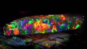
Gemstones have been treasured throughout history for their mesmerizing beauty and captivating allure. Among the many different types of gemstones, iridescent gemstones stand out for their unique play of colors, which seem to dance and shimmer as they catch the light. These enchanting stones exhibit a remarkable phenomenon called iridescence, where colors shift and change depending on the angle of observation and the angle of incident light. In this article, we will delve into the world of iridescent gemstones and explore six of the most stunning and sought-after varieties.
1. Opal: The Queen of Iridescence
The Virgin Rainbow opal from the South Australian Museum opal exhibition. Credit: South Australian Museum.
Opal, often referred to as the “Queen of Gemstones,” is renowned for its captivating play of colors. This mesmerizing gemstone exhibits a stunning array of hues, ranging from fiery reds and oranges to calming blues and greens. The iridescence of opal arises from its unique internal structure, which consists of tiny silica spheres that diffract light. As a result, opals seem to possess an otherworldly quality, as if they capture a piece of the universe within their depths.
Australian opals, particularly those from Lightning Ridge, are some of the most famous and highly prized opals in the world. Ethiopian opals are also gaining popularity for their vibrant play of colors. Opals are often used in jewelry to create eye-catching pieces that reflect the wearer’s personality and style.
2. Moonstone: A Celestial Elegance
Moonstone, Ambalangoda, Sri Lanka
Moonstone, with its ethereal glow reminiscent of the moon’s soft radiance, is another exquisite iridescent gemstone. This feldspar mineral showcases a phenomenon known as adularescence, where light appears to move across the surface, creating a captivating play of blue or white hues. This effect is due to the presence of alternating layers of albite and orthoclase, which scatter light in a unique way.
Moonstone has a long history of significance in various cultures. It is often associated with femininity, intuition, and spirituality. The stone’s gentle shimmer makes it a popular choice for bohemian-inspired jewelry and designs that exude a sense of timeless elegance.
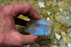
3. Labradorite: Nature’s Canvas of Color
Natural crystal Labradorite Purple Moonstone
Labradorite, with its mesmerizing iridescent colors that resemble a painter’s palette, is a gemstone that truly captures the imagination. This feldspar mineral is known for its vibrant flashes of blue, green, gold, and sometimes even purple. The phenomenon, called labradorescence, occurs due to light interference caused by the presence of internal lamellar structures.
Hailing from the Labrador Peninsula in Canada, this gemstone has a unique charm that has made it a favorite among jewelry designers and collectors. Its captivating colors make it a versatile choice for creating statement pieces that effortlessly transition from day to night.
Peacock Ore, also known as Bornite, is a unique iridescent gemstone that displays a mesmerizing array of metallic colors. This mineral’s surface oxidizes to create a rainbow-like patina of iridescent shades, including deep purples, blues, and bronzes. It is often used as a specimen mineral due to its striking appearance.
Peacock Ore’s colors are reminiscent of the iridescent plumage of a peacock, giving rise to its name. While not as commonly used in jewelry as other gemstones, it is valued for its captivating appearance and is sometimes used in artisanal and unconventional pieces.
5. Pearl: Ocean’s Luminescent Treasure
Various Pearls
Pearls, often associated with elegance and purity, are unique among iridescent gemstones. Unlike other gemstones that derive their iridescence from internal structures, pearls achieve their shimmer through layers of nacre that form around an irritant within an oyster or mollusk. This process results in a captivating play of colors known as orient.
Cultured pearls, which are intentionally grown by pearl farmers, come in various shapes, sizes, and colors. Akoya pearls are prized for their classic white and cream tones, while Tahitian pearls boast a range of colors, including striking blacks and grays. Freshwater pearls, on the other hand, offer a more affordable option with a diverse array of colors.
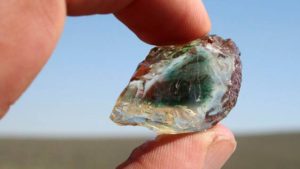
6. Sunstone: A Glimpse of Sunlight
This rough sunstone measures approximately 5 cm (2 inches) in length. Note how the green core follows the contours of the rough. The green core is characteristic of material from this mine. Photo by Duncan Pay.
Sunstone, as its name suggests, is a gemstone that seems to capture the warmth and radiance of the sun. This feldspar mineral is known for its sparkling aventurescence, a phenomenon where light reflects off inclusions of minerals like hematite or goethite. The result is a play of colors that resembles the golden hues of a setting sun.
Oregon sunstone, in particular, is highly regarded for its captivating play of colors ranging from soft peach to intense red. Sunstone’s warm tones make it a popular choice for jewelry that adds a touch of warmth and vibrancy to any ensemble.
In conclusion
iridescent gemstones offer a mesmerizing and enchanting visual experience. From opals and moonstones to labradorite and pearls, these gems each possess a unique play of colors that captivates the beholder. Whether used in jewelry or admired as specimen pieces, these six types of iridescent gemstones remind us of the incredible beauty and diversity that nature has to offer.
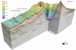
These sections through the seismic volume show the geological structures that record the history of the crater. Illustration: Karstens et al. 2023
The explosion of the underwater volcano Kolumbo in the Aegean Sea in 1650 triggered a destructive tsunami that was described by historical eye witnesses. A group of researchers led by Dr Jens Karstens from the GEOMAR Helmholtz Centre for Ocean Research Kiel has now surveyed Kolumbo’s underwater crater with modern imaging technology and reconstructed the historical events. They found that the eyewitness accounts of the natural disaster can only be described by a combination of a landslide followed by an explosive eruption. Their findings are published today in the journal Nature Communications.
From the Greek island of Santorini, the eruption had been visible for several weeks.
In the late summer of 1650, people reported that the colour of the water had changed and the water was boiling.
About seven kilometres north-east of Santorini, an underwater volcano had risen from the sea and began ejecting glowing rocks.
Fire and lightning could be seen, and plumes of smoke darkened the sky.
Then the water suddenly receded, only to surge towards the coastline moments later, battering it with waves up to 20 metres high.
A huge bang was heard more than 100 kilometres away, pumice and ash fell on the surrounding islands, and a deadly cloud of poisonous gas claimed several lives.
“We know these details of the historic eruption of Kolumbo because there are contemporary reports that were compiled and published by a French volcanologist in the 19th century,” says Dr Jens Karstens, marine geophysicist at GEOMAR Helmholtz Centre for Ocean Research Kiel.
But how did these devastating events come about? To find out, he and his German and Greek colleagues went to the Greek Aegean Sea in 2019 to study the volcanic crater with special technology.
Karstens: “We wanted to understand how the tsunami came about at that time and why the volcano exploded so violently.”
On board the now decommissioned research vessel POSEIDON, the team used 3D seismic methods to create a three-dimensional image of the crater, which is now 18 metres below the water’s surface.
Dr Gareth Crutchley, co-author of the study: “This allows us to look inside the volcano.” Not only did the 3D imaging show that the crater was 2.5 kilometres in diameter and 500 metres deep, suggesting a truly massive explosion, the seismic profiles also revealed that one flank of the cone had been severely deformed.
Crutchley: “This part of the volcano has certainly slipped.” The researchers then took a detective’s approach, comparing the various mechanisms that could have caused the tsunami with the historical eyewitness accounts.
They concluded that only a combination of a landslide followed by a volcanic explosion could explain the tsunami.
Their findings are published today in the journal Nature Communications.
By combining 3D seismics with computer simulations, the researchers were able to reconstruct how high the waves would have been if they had been generated by the explosion alone.
Karstens: “According to this, waves of six metres would have been expected at one particular location, but we know from the reports of eyewitnesses that they were 20 metres high there.” Furthermore, the sea is said to have first receded at another point, but in the computer simulation a wave crest reaches the coast first.
Thus, the explosion alone cannot explain the tsunami event. However, when the landslide was included in the simulations, the data agreed with historical observations.
Jens Karstens explains: “Kolumbo consists partly of pumice with very steep slopes. It is not very stable. During the eruption, which had been going on for several weeks, lava was continuously ejected. Underneath, in the magma chamber, which contained a lot of gas, there was enormous pressure. When one of the volcano’s flanks slipped, the effect was like uncorking a bottle of champagne: the sudden release of pressure allowed the gas in the magma system to expand, resulting in a huge explosion.” Something similar could have happened during the 2022 eruption of the Hunga Tonga undersea volcano, whose volcanic crater has a similar shape to Kolumbo’s.
The study thus provides valuable information for the development of monitoring programmes for active submarine volcanic activity, such as SANTORY, which is led by co-author Prof.
Dr Paraskevi Nomikou of the National and Kapodistrian University of Athens (NKUA). “We hope to be able to use our results to develop new approaches to monitor volcanic unrest,” says Jens Karstens, “maybe even an early warning system, collecting data in real time. That would be my dream.”
About 3D Marine Reflection Seismics
3D seismics is a geophysical technique that exploits the fact that sound waves are partially reflected at the boundaries of layers. This makes it possible to create cross-sectional profiles of geological structures beneath the seabed. Unlike 2D reflection seismics, marine 3D reflection seismics uses multiple measuring cables (housing receivers) towed in parallel behind the research vessel. The result is a three-dimensional image, known as a seismic volume, which allows us to look beneath the seafloor and analyse the geology in detail.
Reference:
Jens Karstens, Gareth J. Crutchley, Thor H. Hansteen, Jonas Preine, Steven Carey, Judith Elger, Michel Kühn, Paraskevi Nomikou, Florian Schmid, Giacomo Dalla Valle, Karim Kelfoun, Christian Berndt. Cascading events during the 1650 tsunamigenic eruption of Kolumbo volcano. Nature Communications, 2023; 14 (1) DOI: 10.1038/s41467-023-42261-y
Venus, a scorching wasteland of a planet according to scientists, may have once had tectonic plate movements similar to those believed to have occurred on early Earth, a new study found. The finding sets up tantalizing scenarios regarding the possibility of early life on Venus, its evolutionary past and the history of the solar system.
Writing in Nature Astronomy, a team of scientists led by Brown University researchers describes using atmospheric data from Venus and computer modeling to show that the composition of the planet’s current atmosphere and surface pressure would only have been possible as a result of an early form of plate tectonics, a process critical to life that involves multiple continental plates pushing, pulling and sliding beneath one another.
On Earth, this process intensified over billions of years, forming new continents and mountains, and leading to chemical reactions that stabilized the planet’s surface temperature, resulting in an environment more conducive to the development of life.
Venus, on the other hand, Earth’s nearest neighbor and sister planet, went in the opposite direction and today has surface temperatures hot enough to melt lead. One explanation is that the planet has always been thought to have what’s known as a “stagnant lid,” meaning its surface has only a single plate with minimal amounts of give, movement and gasses being released into the atmosphere.
The new paper posits that this wasn’t always the case. To account for the abundance of nitrogen and carbon dioxide present in Venus’ atmosphere, the researchers conclude that Venus must have had plate tectonics sometime after the planet formed, about 4.5 billion to 3.5 billion years ago. The paper suggests that this early tectonic movement, like on Earth, would have been limited in terms of the number of plates moving and in how much they shifted. It also would have been happening on Earth and Venus simultaneously.
“One of the big picture takeaways is that we very likely had two planets at the same time in the same solar system operating in a plate tectonic regime — the same mode of tectonics that allowed for the life that we see on Earth today,” said Matt Weller, the study’s lead author who completed the work while he was a postdoctoral researcher at Brown and is now at the Lunar and Planetary Institute in Houston.
This bolsters the possibility of microbial life on ancient Venus and shows that at one point the two planets — which are in the same solar neighborhood, are about the same size, and have the same mass, density and volume — were more alike than previously thought before diverging.
The work also highlights the possibility that plate tectonics on planets might just come down to timing — and therefore, so may life itself.
“We’ve so far thought about tectonic state in terms of a binary: it’s either true or it’s false, and it’s either true or false for the duration of the planet,” said study co-author Alexander Evans, an assistant professor of Earth, environmental and planetary sciences at Brown. “This shows that planets may transition in and out of different tectonic states and that this may actually be fairly common. Earth may be the outlier. This also means we might have planets that transition in and out of habitability rather than just being continuously habitable.”
That concept will be important to consider as scientists look to understand nearby moons — like Jupiter’s Europa, which has shown proof of having Earth-like plate tectonics — and distant exoplanets, according to the paper.
The researchers initially started the work as a way to show that the atmospheres of far-off exoplanets can be powerful markers of their early histories, before deciding to investigate that point closer to home.
They used current data on Venus’ atmosphere as the endpoint for their models and started by assuming Venus has had a stagnant lid through its entire existence. Quickly, they were able to see that simulations recreating the planet’s current atmosphere didn’t match up with where the planet is now in terms of the amount nitrogen and carbon dioxide present in the current atmosphere and its resulting surface pressure.
The researchers then simulated what would have had to happen on the planet to get to where it is today. They eventually matched the numbers almost exactly when they accounted for limited tectonic movement early in Venus’ history followed by the stagnant lid model that exists today.
Overall, the team believes the work serves as a proof of concept regarding atmospheres and their ability to provide insights into the past.
“We’re still in this paradigm where we use the surfaces of planets to understand their history,” Evans said. “We really show for the first time that the atmosphere may actually be the best way to understand some of the very ancient history of planets that is often not preserved on the surface.”
Upcoming NASA DAVINCI missions, which will measure gasses in the Venusian atmosphere, may help solidify the study’s findings. In the meantime, the researchers plan to delve deep into a key question the paper raises: What happened to plate tectonics on Venus? The theory in the paper suggests that the planet ultimately became too hot and its atmosphere too thick, drying up the necessary ingredients for tectonic movement.
“Venus basically ran out of juice to some extent, and that put the brakes on the process,” said Daniel Ibarra, a professor in Brown’s Department of Earth, Environmental and Planetary Sciences and co-author on the paper.
The researchers say the details of how this happened may hold important implications for Earth.
“That’s going to be the next critical step in understanding Venus, its evolution and ultimately the fate of the Earth,” Weller said. “What conditions will force us to move in a Venus-like trajectory, and what conditions could allow the Earth to remain habitable?”
The study also included Alexandria Johnson from Purdue University. It was supported by NASA’s Solar System Workings program.
Reference:
Matthew B. Weller, Alexander J. Evans, Daniel E. Ibarra, Alexandria V. Johnson. Venus’s atmospheric nitrogen explained by ancient plate tectonics. Nature Astronomy, 2023; DOI: 10.1038/s41550-023-02102-w
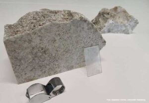
For the microscopic examination, a thin section of the whiteschist was glued to a glass slide (center of the picture). Photo: Sebastian Cionoiu, Heidelberg University
Examining how plates move in Earth’s mantle and how mountains form is no easy feat. Certain rocks that have sunk deep into Earth’s interior and then returned from there can deliver answers.
Geoscientists analyze rocks in mountain belts to reconstruct how they once moved downwards into the depths and then returned to the surface.
This history of burial and exhumation sheds light on the mechanisms of plate tectonics and mountain building.
Certain rocks that sink far down into Earth’s interior together with plates are transformed into different types under the enormous pressure that prevails there.
During this UHP metamorphosis (UHP: Ultra High Pressure), silica (SiO2) in the rock, for example, becomes coesite, which is also referred to as the UHP polymorph of SiO2. Although it is chemically still silica, the crystal lattices are more tightly packed and therefore denser.
When the plates move upwards again from the depths, the UHP rocks also come to the surface and can be found in certain places in the mountains.
Their mineral composition provides information about the pressures to which they were exposed during their vertical journey through Earth’s interior.
Using lithostatic pressure as a unit of measurement, it is possible to correlate pressure and depth: the higher the pressure, the deeper the rocks once lay.
Until now, research had assumed that UHP rocks were buried at a depth of 120 kilometers.
From there, they returned to the surface together with the plates.
In the process, ambient pressure decreased at a stable rate, i.e. statically.
However, a new study by Goethe University Frankfurt and the universities of Heidelberg and Rennes (France) calls this assumption of a long, continuous ascent into question.
Among those involved in the study on the part of Goethe University Frankfurt were first author Cindy Luisier, who came to the university on a Humboldt Research Fellowship, and Thibault Duretz, head of the Geodynamic Modeling Working Group at the Department of Geosciences.
The research team analyzed whiteschist from the Dora Maira Massif in the Western Alps, Italy.
“Whiteschists are rocks that formed as a result of the UHP metamorphosis of a hydrothermally altered granite during the formation of the Alps,” explains Duretz.
“What is special about them is the large amount of coesite. The coesite crystals in the whiteschist are several hundred micrometers in size, which makes them ideal for our experiments.” The piece of whiteschist from the Dora Maira Massif contained pink garnets in a silvery-white matrix composed of quartz and other minerals.
“The rock has special chemical and thus mineralogical properties,” says Duretz.
Together with the team, he analyzed it by first cutting a very thin slice about 50 micrometers thick and then gluing it onto glass.
In this way, it was possible to identify the minerals under a microscope.
The next step was computer modeling of specific, particularly interesting areas.
These areas were silica particles surrounded by the grains of pink garnet, in which two SiO2 polymorphs had formed.
One of these was coesite, which had formed under very high pressure (4.3 gigapascals). The other silica polymorph was quartz, which lay like a ring around the coesite.
It had formed under much lower pressure (1.1 gigapascals). The whiteschist had evidently first been exposed to very high and then much lower pressure.
There had been a sharp decrease in pressure or decompression.
The most important discovery was that spoke-shaped cracks radiated from the SiO2 inclusions in all directions: the result of the phase transition from coesite to quartz.
The effect of this transition was a large change in volume, and it caused extensive geological stresses in the rock.
These made the garnet surrounding the SiO2 inclusions fracture.
“Such radial cracks can only form if the host mineral, the garnet, stays very strong,” explains Duretz.
“At such temperatures, garnet only stays very strong if the pressure drops very quickly.” On a geological timescale, “very quickly” means in thousands to hundreds of thousands of years.
In this “short” period, the pressure must have dropped from 4.3 to 1.1 gigapascals.
The garnet would otherwise have creeped viscously to compensate for the change in volume in the SiO2 inclusions, instead of forming cracks.
According to Duretz, the previous assumption that UHP rock reaches a depth of 120 kilometers seems less probable in view of this rapid decompression because the ascent from such a depth would take place over a long period of time, which does not equate with the high decompression rate, he says. “We rather presume that our whiteschist lay at a depth of only 60 to 80 kilometers,” says the geoscientist. And the processes underway in Earth’s interior could also be quite different than assumed in the past. That rock units move continuously upwards over great distances, from a depth of 120 kilometers to the surface, also seems less probable than previously thought. “Our hypothesis is that rapid tectonic processes took place instead, which led to minimal vertical plate displacements.” We can imagine it like this, he says: The plates suddenly jerked upwards a little bit in Earth’s interior — and as a result the pressure surrounding the UHP rock decreased in a relatively short time.
Ca-silicate inclusion inside a diamond from Kankan, Guinea. Photo credit: Margo Regier.
Diamonds contain evidence of the mantle rocks that helped buoy and grow the ancient supercontinent Gondwana from below, according to new research from a team of scientists led by Suzette Timmerman — formerly of the University of Alberta and now at the University of Bern — and including Carnegie’s Steven Shirey, Michael Walter, and Andrew Steele. Their findings, published in Nature, demonstrate that superdeep diamonds can provide a window through space and time into the supercontinent growth and formation process.
For billions of years, Earth’s landmasses have been ripped apart and smashed back together by plate tectonics, periodically forming giant supercontinents. This formation process results from large-scale convection of the planet’s mantle. But the records of these events are poorly preserved, because the oceanic crust is young and continually sinks beneath the planet’s surface by a process called subduction, while the continental crust only provides a limited view of Earth’s deep workings.
Surprisingly, the research team was able to show that superdeep diamonds that formed between 300 and 700 kilometers below Earth’s surface can reveal how material was added to the base of a once-mighty supercontinent.
“These diamonds allow us to see how deep plate tectonic processes relate to the supercontinent cycle,” Shirey said.
The supercontinent Gondwana is thought to have formed between 800 and 550 million years ago in Neoproterozoic times. Starting over the present-day location of the South Pole, it incorporated the landmasses that make up present day South America, Africa, the Middle East, India, and Australia.
“By revealing the geological processes that contributed to Gondwana’s growth, scientists can better understand the forces that shaped Earth’s history and phenomenon of continental stability, which is — of course — fundamental to the eventual success of life on our planet,” added Walter.
About 40 to 250 kilometers beneath the surface, geologic formations called mantle keels act as the foundation of the continental crust. The material that forms these keels thickened, stabilized, and cooled under the continental blocks to form strong, buoyant structures that can resist the relentless destructive forces of Earth’s tectonic activity.
Remnants of the mantle rocks that helped form the keel can be found in tiny silicate and sulfide inclusions hidden inside these superdeep diamonds. Typically flaws in normal gem diamonds, these inclusions are the best friends of a geoscientist. They were identified, isolated, studied crystallographically, and then radiometrically dated to determine their geologic ages.
This work was carried out by researchers at the University of Alberta and the Carnegie Institution for Science, as well as by other teams of diamond specialists at the Vrije Universiteit Amsterdam, University of Bristol, and the University of Padua. It required many steps, including shipping the diamonds around the world several times, and deployed some of the most precise mass spectrometers and X-ray diffractometers available.
“The study of such rare samples with a variety of measurement techniques required major teamwork. But even more remarkable is how careful analyses of such minute amounts of material can shed light on the evolution of Earth’s largest continental landmasses,” Timmerman explained.
“The age of these inclusions provides a record of when buoyant mantle was added to Gondwana from below, thereby scaffolding, underpinning, and growing the supercontinent” added Shirey.
Then, about 120 million years ago, the supercontinent once buoyed by the rocks that housed these diamonds started to break up and, eventually, 30 million years later — around 90 million years ago — the diamonds — and the inclusions trapped inside them — were brought to the Earth’s surface in violent volcanic eruptions of diamond-bearing kimberlite magma.
Now, by combining their lab analysis with existing models of tectonic movement and continent migration, the researchers can use these remarkably well-traveled diamonds to understand how material welds continental fragments together from below, stabilizing such a super-sized continental landmass.
Reference:
Suzette Timmerman, Thomas Stachel, Janne M. Koornneef, Karen V. Smit, Rikke Harlou, Geoff M. Nowell, Andrew R. Thomson, Simon C. Kohn, Joshua H. F. L. Davies, Gareth R. Davies, Mandy Y. Krebs, Qiwei Zhang, Sarah E. M. Milne, Jeffrey W. Harris, Felix Kaminsky, Dmitry Zedgenizov, Galina Bulanova, Chris B. Smith, Izaac Cabral Neto, Francisco V. Silveira, Antony D. Burnham, Fabrizio Nestola, Steven B. Shirey, Michael J. Walter, Andrew Steele, D. Graham Pearson. Sublithospheric diamond ages and the supercontinent cycle. Nature, 2023; DOI: 10.1038/s41586-023-06662-9
The analysis of ancient, superdeep diamonds dug up from mines in Brazil and Western Africa, has exposed new processes of how continents evolved and moved during the early evolution of complex life on Earth.
These diamonds that were formed between 650 and 450 million years ago on the base of the supercontinent Gondwana, were analysed by an international team of experts, and have shown how supercontinents such as Gondwana were formed, stabilised, and how they move around the planet.
“Superdeep diamonds are extremely rare and we now know that they can tell us a lot about the whole process of continent formation,” says Dr Karen Smit of the Wits School of Geosciences, who was part of the study. “We wanted to date these diamonds to try and understand how the earliest continents formed.”
Formed millions to billions of years ago, diamonds can shine light into the darkest and oldest parts of the Earth’s mantle. Continents drift across Earth’s surface creating “supercontinents” and destroying them. Collectively, these migrations are known as the “supercontinent cycle” and diamonds are one of the few minerals strong enough to survive and record these ancient cycles of creation and destruction.
Supercontinents can focus deep oceanic plate subduction — the driver of plate tectonics — in very specific regions. Such deep geologic processes, especially in the past, have been very difficult to study directly because the oceanic crust is young, and the continental crust only provides a limited view of Earth’s deep workings. Old diamonds offer a direct window into the deep plate tectonic engine and how it might relate to the supercontinent cycle.
By dating the tiny silicate and sulphide inclusions inside the diamonds, the team led by Dr Suzette Timmerman of the University of Bern, Switzerland, dated the diamonds that formed 300 to 700km deep under the base of Gondwana. The goal was to trace how material was added to the keel of the supercontinent. While doing this, the team recognised a previously unknown geologic process. The research was published in Nature on Wednesday, October 18.
“The geochemical analyses and dating of inclusions in the diamonds, combined with existing plate tectonic models of continent migration, showed that diamonds formed at great depths beneath Gondwana when the supercontinent covered the South Pole, between 650-450 million years ago,” says Smit.
The host rocks to the diamonds became buoyant during diamond formation, transporting subducted mantle material plus the diamonds. This material was added to the base of the root of Gondwana, in essence ‘growing’ the supercontinent from below.
“Around 120 million years ago, Gondwana started to break apart to form the present oceans such as the Atlantic. At 90 million years ago, the diamonds, carrying trapped tiny inclusions of the host rock, were brought to Earth’s surface in violent volcanic eruptions.”
The current locations for these volcanic eruptions are on the continental fragments of Brazil and Western Africa, two of the key components of Gondwana. Thus, the diamonds must have migrated together with different parts of the former supercontinent as it dispersed, “glued” to their base.
“This complex history of the diamonds shows that they are remarkably well-travelled, both vertically, and horizontally, within the Earth — tracing both the formation of the supercontinent and the latter stages of its evolution. The accretion of relatively young material to the roots of the continents thickens and welds together these ancient continental fragments indicating a potential new mode of continent growth.”
Smit conducted the isotope analyses of sulphide inclusions at Carnegie Institution for Science. Smit is now based at the University of the Witwatersrand where she is part of a team developing a new isotope lab and methodologies so that diamond inclusion analyses can ultimately be conducted at Wits.
“We have installed the necessary equipment in 2022 and are working towards getting the highly specialised skills and equipment together so we can do this type of diamond work in South Africa, where previously it could only be done overseas,” says Smit.
“We need this type of research to understand how continents evolve and move. Without continents there wouldn’t be life. This research gives us insight into how continents form, and it links to how life evolved and what makes our planet, Earth, different from other planets.”
Reference:
Suzette Timmerman, Thomas Stachel, Janne M. Koornneef, Karen V. Smit, Rikke Harlou, Geoff M. Nowell, Andrew R. Thomson, Simon C. Kohn, Joshua H. F. L. Davies, Gareth R. Davies, Mandy Y. Krebs, Qiwei Zhang, Sarah E. M. Milne, Jeffrey W. Harris, Felix Kaminsky, Dmitry Zedgenizov, Galina Bulanova, Chris B. Smith, Izaac Cabral Neto, Francisco V. Silveira, Antony D. Burnham, Fabrizio Nestola, Steven B. Shirey, Michael J. Walter, Andrew Steele, D. Graham Pearson. Sublithospheric diamond ages and the supercontinent cycle. Nature, 2023; DOI: 10.1038/s41586-023-06662-9
New research focused on the quantum structure of elements under extreme conditions has implications for understanding Earth’s evolution, interpreting unusual seismic signals, and even the study of exoplanets for insights into habitability.
Deep inside rocky planets like Earth, the behavior of iron can greatly affect the properties of molten rock materials: properties that influenced how Earth formed and evolved.
In fact, the evolution of our entire planet may be driven by the microscopic quantum state of these iron atoms. One special feature of iron is its “spin state,” which is a quantum property of the electrons in each iron atom that drives their magnetic behavior and reactivity in chemical reactions. Changes in the spin state can influence whether iron prefers to be in the molten rock or in solid form and how well the molten rock conducts electricity.
Until now, it’s been challenging to recreate the extreme conditions in these molten rock materials, called silicate melts, to measure the spin state of iron. Using powerful lasers and ultrafast X-rays, an international team of researchers at the Department of Energy’s SLAC National Accelerator Laboratory, Stanford University, Universite Grenoble Alpes, Laboratoire pour l’Utilisation des Lasers Intenses (LULI), and Arizona State University overcame this challenge. They showed that at extremely high pressures and temperatures, the iron in silicate melts mostly has a low-spin state, meaning its electrons stay closer to the center and pair up in their energy levels, making the iron less magnetic and more stable.
The results, published Friday in Science Advances, support the idea that certain types of molten rock might be stable deep inside Earth and other rocky planets, potentially lending a hand in the creation of magnetic fields. The research has potential implications for understanding Earth’s evolution, interpreting seismic signals, and even the study of exoplanets.
“In terms of exploring Earth’s history, we’re investigating processes that took place over 4 billion years ago,” said collaborator Dan Shim, a researcher at Arizona State. “The only way to study this is by using modern technology that operates in femtoseconds. The contrast between these immense time scales is both eloquent and startling: it’s akin to the idea of a time machine.”
Asteroid bombardment and magmatic oceans
About 4.3 to 4.5 billion years ago, early Earth underwent intense impacts, getting pummeled by asteroids as large as cities. These impacts produced so much heat that they could have completely melted the outer layers of the planet, creating a deep ocean of molten rock.
“It’s been theorized that under the immense pressure of these impacts, the molten rock may have became denser than the solid rock,” said collaborator and SLAC scientist Arianna Gleason. “This denser magma would have sunk towards the core, capturing the chemical signatures of that era. Some believe remnants of this magma layer may still exist today, holding clues from 4.5 billion years ago. Volcanoes like those in Hawaii could be releasing these ancient chemical signatures, providing us a glimpse into Earth’s distant past.”
At shallow depths, molten rock takes up more space than the same material when it’s solid. But as you go deeper and the pressure increases, this difference decreases. The inclusion of iron, especially its spin state, plays a big role in determining these properties. Prior research has shown mixed results about the spin state of iron in similar conditions: some studies found a rapid change in iron’s spin state under high pressures, while others saw a slower, more gradual change.
This new study provides the first direct look at iron’s behavior in real molten rock under extreme conditions.
“While we can glean a lot from studying rocks and fossils, some aspects of Earth’s early history are lost because few records from that time exist,” Shim said. “That’s what makes this study unique. Earth’s formation was a tumultuous process, involving intense impacts and resulting in a globally molten rock layer. The pressure in this layer was immense. We study this by simulating the conditions through laboratory experiments.”
At the Matter in Extreme Conditions (MEC) experimental hutch at SLAC’s Linac Coherent Light Source (LCLS), the team was able to recreate the extreme pressures that would have been found in early Earth’s magmatic ocean by blasting samples with powerful lasers that transform the solid material into a silicate melt in a matter of nanoseconds. Then, the scientists used femtosecond X-ray pulses from LCLS to study the electronic structure of elements like iron under these extreme conditions, providing insights into how electronic configurations change under different conditions and revealing that the molten magma did indeed become denser than a solid under specific conditions.
“By understanding Earth’s internal dynamics, we can refine models of tectonic movement and other geological phenomena,” Gleason said. “Moreover, as Earth’s layers are interconnected, these findings have implications for climate science.”
Understanding our planet
In this research the team concentrated on low iron content melts. But as material rains down towards the Earth’s center, it’s theorized to absorb more iron, making it denser. To follow up, the team plans to study melts with higher iron content. They also hope to experiment with melts containing some water, furthering our understanding of Earth’s water cycle and climate.
The research could also shed light on peculiar seismic velocities deep within Earth’s mantle. These anomalies have puzzled scientists for decades. Some theories suggest these zones could be remnants of magma from 4.5 billion years ago, while others believe they result from tectonic plates that have sunk into the Earth’s interior, spreading low melting point material. By comparing different hypotheses using seismic imaging, the team aims to determine the origins of these zones and distinguish between ancient and more recent materials.
“As technology advances, we’re at the forefront of addressing grand challenges that range from mineralogy to climate science, connecting various research areas,” said SLAC scientist and collaborator Roberto Alonso-Mori. “The sheer volume of information we can gather has transformed our capabilities. It’s a game-changer. It’s exhilarating to develop novel techniques and apply them to pressing questions with such a diverse team.”
Reference:
Sang-Heon Shim, Byeongkwan Ko, Dimosthenis Sokaras, Bob Nagler, He Ja Lee, Eric Galtier, Siegfried Glenzer, Eduardo Granados, Tommaso Vinci, Guillaume Fiquet, Jonathan Dolinschi, Jackie Tappan, Britany Kulka, Wendy L. Mao, Guillaume Morard, Alessandra Ravasio, Arianna Gleason, Roberto Alonso-Mori. Ultrafast x-ray detection of low-spin iron in molten silicate under deep planetary interior conditions. Science Advances, 2023; 9 (42) DOI: 10.1126/sciadv.adi6153
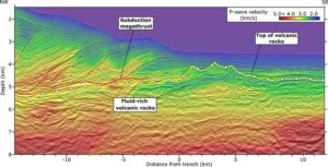
Cross section seismic profile of the Earth.A seismic image of the Hikurangi plateau reveals details about the Earth’s interior and what it’s made of. The blue-green layer under the yellow line shows water buried within rocks. Researchers at the University of Texas Institute for Geophysics think the water could be dampening earthquakes at the nearby Hikurangi subduction zone. Credit: Andrew Gase
Researchers have discovered a sea’s worth of water locked within the sediment and rock of a lost volcanic plateau that’s now deep in the Earth’s crust. Revealed by a 3D seismic image, the water lies two miles under the ocean floor off the coast of New Zealand, where it may be dampening a major earthquake fault that faces the country’s North Island.
The fault is known for producing slow-motion earthquakes, called slow slip events. These can release pent-up tectonic pressure harmlessly over days and weeks. Scientists want to know why they happen more often at some faults than others.
Many slow slip earthquakes are thought to be linked to buried water. However, until now there was no direct geologic evidence to suggest such a large water reservoir existed at this particular New Zealand fault.
“We can’t yet see deep enough to know exactly the effect on the fault, but we can see that the amount of water that’s going down here is actually much higher than normal,” said the study’s lead author, Andrew Gase, who did the work as a postdoctoral fellow at the University of Texas Institute for Geophysics (UTIG).
The research was published in the journal Science Advances and is based on seismic cruises and scientific ocean drilling led by UTIG researchers.
Gase, who is now a postdoctoral fellow at Western Washington University, is calling for deeper drilling to find where the water ends up so that researchers can determine whether it affects pressure around the fault — an important piece of information that could lead to more precise understanding of large earthquakes, he said.
The site where the researchers found the water is part of a vast volcanic province that formed when a plume of lava the size of the United States breached the Earth’s surface in the Pacific Ocean 125 million years ago. The event was one of the Earth’s largest known volcanic eruptions and rumbled on for several million years.
Gase used seismic scans to build a 3D picture of the ancient volcanic plateau in which he saw thick, layered sediments surrounding buried volcanoes. His UTIG collaborators ran lab experiments on drill core samples of the volcanic rock and found that water made up nearly half of its volume.
“Normal ocean crust, once it gets to be about 7 or 10 million years old should contain much less water,” he said. The ocean crust in the seismic scans was ten times as old, but it had remained much wetter.
Gase speculates that the shallow seas where the eruptions took place eroded some of the volcanoes into a porous, broken-up rock that stored water like an aquifer as it was buried. Over time, the rock and rock fragments transformed into clay, locking in even more water.
The finding is important because scientists think that underground water pressure may be a key ingredient in creating conditions that release tectonic stress via slow slip earthquakes. This usually happens when water-rich sediments are buried with the fault, trapping the water underground. However, the New Zealand fault contains little of this typical ocean sediment. Instead, the researchers think the ancient volcanoes and the transformed rocks — now clays — are carrying large volumes of water down as they’re swallowed by the fault.
UTIG Director Demian Saffer, a study coauthor and co-chief scientist on the scientific drilling mission, said the findings suggest that other earthquake faults around the globe could be in similar situations.
“It’s a really clear illustration of the correlation between fluids and the style of tectonic fault movement — including earthquake behavior,” he said. “This is something that we’ve hypothesized from lab experiments, and is predicted by some computer simulations, but there are very few clear field experiments to test this at the scale of a tectonic plate.”
The research was funded by the U.S. National Science Foundation and science and research agencies in New Zealand, Japan and the United Kingdom.
Reference:
Andrew C. Gase, Nathan L. Bangs, Demian M. Saffer, Shuoshuo Han, Peter K. Miller, Rebecca E. Bell, Ryuta Arai, Stuart A. Henrys, Shuichi Kodaira, Richard Davy, Laura Frahm, Daniel H. N. Barker. Subducting volcaniclastic-rich upper crust supplies fluids for shallow megathrust and slow slip. Science Advances, 2023; 9 (33) DOI: 10.1126/sciadv.adh0150
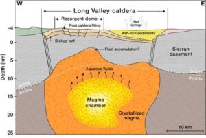
A diagram depicting the magma chamber beneath the Long Valley Caldera. The diagram was developed from tomographic imaging using seismic waves. Credit: Biondi et al. (2023)
Since the 1980s, researchers have observed significant periods of unrest in a region of California’s Eastern Sierra Nevada mountains characterized by swarms of earthquakes as well as the ground inflating and rising by almost half an inch per year during these periods. The activity is concerning because the area, called the Long Valley Caldera, sits atop a massive dormant supervolcano. Seven hundred and sixty thousand years ago, the Long Valley Caldera was formed in a violent eruption that sent 650 cubic kilometers of ash into the air — a volume that could cover the entire Los Angeles area in a layer of sediment 1 kilometer thick.
What is behind the increased activity in the last few decades? Could it be that the area is preparing to erupt again? Or could the uptick in activity actually be a sign that the risk of a massive eruption is decreasing?
To answer these questions, Caltech researchers have created the most detailed underground images to date of the Long Valley Caldera, reaching depths up to 10 kilometers within the Earth’s crust. These high-resolution images reveal the structure of the earth beneath the caldera and show that the recent seismic activity is a result of fluids and gases being released as the area cools off and settles down.
The work was conducted in the laboratory of Zhongwen Zhan (PhD ’14), professor of geophysics. A paper describing the research appears in the journal Science Advances on October 18.
“We don’t think the region is gearing up for another supervolcanic eruption, but the cooling process may release enough gas and liquid to cause earthquakes and small eruptions,” says Zhan. “For example, in May 1980, there were four magnitude 6 earthquakes in the region alone.”
The high-resolution image shows that the volcano’s magma chamber is covered by a hardened lid of crystallized rock, formed as the liquid magma cools down and solidifies.
To create underground images, the researchers infer what the subsurface environment looks like by measuring seismic waves from earthquakes. Earthquakes generate of two types of seismic waves: primary (P-waves) and secondary (S-waves). Both kinds of waves travel at different speeds through different materials — waves are slowed down by elastic materials like liquids but travel quickly through very rigid materials like rock. Using seismometers at various locations allows one to measure discrepancies in the timing of the waves and determine the characteristics of the materials — how elastic or rigid — they traveled through. In this way, researchers can create images of the subsurface environment.
Though there are several dozen seismometers placed throughout the Eastern Sierra region, Zhan’s technique utilizes fiber optic cables (like those that provide internet) to make seismic measurements in a process called distributed acoustic sensing (DAS). The 100-kilometer stretch of cable used to image the Long Valley Caldera was comparable to a stretch of 10,000 single-component seismometers. Over a year and a half, the team used the cable to measure more than 2,000 seismic events, most too small to be felt by people. A machine learning algorithm processed those measurements and developed the resulting image.
This study is the first time that such deep, high-resolution images have been created with DAS. Previous images from local tomography studies have either been confined only to the shallow subsurface environment at depths of about 5 kilometers, or covered a larger area in lower resolution.
“This is one of the first demonstrations of how DAS can change our understanding of crustal dynamics,” says Ettore Biondi, DAS scientist at Caltech and the paper’s first author. “We’re excited to apply similar technology to other regions where we are curious about the subsurface environment.”
Next, the team plans to use a 200-kilometer length of cable to image even deeper into the Earth’s crust, to around 15 to 20 kilometers deep, where the caldera’s magma chamber — its “beating heart” — is cooling.
The paper is titled “An upper-crust lid over the Long Valley magma chamber.” In addition to Biondi and Zhan, co-authors are former Caltech postdoctoral fellow Weiqiang Zhu, now of UC Berkeley; Caltech postdoctoral scholar Jiaxuan Li; and former Caltech graduate student Ethan Williams (MS ’19, PhD ’23), now of the University of Washington. Funding was provided by the National Science Foundation, the Resnick Sustainability Institute at Caltech, and the Gordon and Betty Moore Foundation.
Reference:
Ettore Biondi, Weiqiang Zhu, Jiaxuan Li, Ethan F. Williams, Zhongwen Zhan. An upper-crust lid over the Long Valley magma chamber. Science Advances, 2023; 9 (42) DOI: 10.1126/sciadv.adi9878
Coloured diamonds from the Argyle diamond mine. Image: Murray Rayner, Rio Tinto
Curtin University researchers studying diamond-rich rocks from Western Australia’s Argyle volcano have identified the missing third key ingredient needed to bring valuable pink diamonds to the Earth’s surface where they can be mined, which could greatly help in the global hunt for new deposits.
While it is known that for diamonds to form there needs to be carbon deep in the Earth, and for these diamonds to turn pink they must be subjected to forces from colliding tectonic plates, the new study has found the third ingredient needed for the presence of pink diamonds at surface level, which is continents that were ‘stretched’ during continental break-up hundreds of millions of years ago.
Lead researcher Dr Hugo Olierook, from Curtin’s John de Laeter Centre, said the ‘stretching’ of landmasses created gaps in the Earth’s crust through which diamond-carrying magma could rise to the surface.
“By using laser beams smaller than the width of a human hair on rocks supplied by Rio Tinto, we found Argyle to be 1.3 billion years old, which is 100 million years older than previously thought, meaning it would likely have formed as a result of an ancient supercontinent breaking apart,” Dr Olierook said.
“Argyle is located at the point where the Kimberley region and the rest of northern Australia smashed together many years prior, and that sort of collision creates a damaged area or ‘scar’ in the land that will never fully heal.
“While the continent that would become Australia didn’t break up, the area where Argyle is situated was stretched, including along the scar, which created gaps in the Earth’s crust for magma to shoot up through to the surface, bringing with it pink diamonds.
“As long as these three ingredients are present — deep carbon, continental collision and then stretching — then we think it will be possible to find the ‘next Argyle’, which was once the world’s largest source of natural diamonds.”
Dr Olierook said even with the knowledge of these three ingredients, finding another trove of pink diamonds will not be without its challenges.
“Most diamond deposits have been found in the middle of ancient continents because their host volcanoes tend to be exposed at the surface for explorers to find,” Dr Olierook said.
“Argyle is at the suture of two of these ancient continents, and these edges are often covered by sand and soil, leaving the possibility that similar pink diamond-bearing volcanoes still sit undiscovered, including in Australia.”
Co-author and principal geologist Murray Rayner, from Rio Tinto, said the Argyle volcano has produced more than 90 percent of the world’s pink diamonds, making it an unparalleled source of these rare and coveted gems.
“Knowing the Argyle volcano’s age, at 1.3 billion years old, and situated where some of Earth’s earliest continents fragmented, we have significant further insights into the formation of these diamonds,” Rayner said.
The authors are affiliated with the John de Laeter Centre, the Timescales of Mineral Systems Group and the Earth Dynamics Research Group, which sit within Curtin’s School of Earth and Planetary Sciences. The work was enabled by AuScope and the Australian Government via the National Collaborative Research Infrastructure Strategy.
Reference:
Hugo K. H. Olierook, Denis Fougerouse, Luc S. Doucet, Yebo Liu, Murray J. Rayner, Martin Danišík, Daniel J. Condon, Brent I. A. McInnes, A. Lynton Jaques, Noreen J. Evans, Bradley J. McDonald, Zheng-Xiang Li, Christopher L. Kirkland, Celia Mayers, Michael T. D. Wingate. Emplacement of the Argyle diamond deposit into an ancient rift zone triggered by supercontinent breakup. Nature Communications, 2023; 14 (1) DOI: 10.1038/s41467-023-40904-8
Note: The above post is reprinted from materials provided by Curtin University. Original written by Lucien Wilkinson.
Preservation of corneous β-proteins in Mesozoic feathers Photographs of fossil specimens used in this study.
Palaeontologists at University College Cork (UCC) in Ireland have discovered X-ray evidence of proteins in fossil feathers that sheds new light on feather evolution.
Previous studies suggested that ancient feathers had a different composition to the feathers of birds today. The new research, however, reveals that the protein composition of modern-day feathers was also present in the feathers of dinosaurs and early birds, confirming that the chemistry of feathers originated much earlier than previously thought.
The research, published today in Nature Ecology and Evolution, was led by palaeontologists Dr Tiffany Slater and Prof. Maria McNamara of UCC’s School of Biological, Earth, and Environmental Science, who teamed with scientists based at Linyi University (China) and the Stanford Synchrotron Radiation Lightsource (USA).
The team analysed 125-million-year-old feathers from the dinosaur Sinornithosaurus and the early bird Confuciusornis from China, plus a 50-million-year-old feather from the USA.
“It’s really exciting to discover new similarities between dinosaurs and birds,” Dr Slater says. “To do this, we developed a new method to detect traces of ancient feather proteins. Using X-rays and infrared light we found that feathers from the dinosaur Sinornithosaurus contained lots of beta-proteins, just like feathers of birds today.”
To help interpret the chemical signals preserved in the fossil feathers, the team also ran experiments to help understand how feather proteins break down during the fossilization process.
“Modern bird feathers are rich in beta-proteins that help strengthen feathers for flight,” Dr Slater says.
“Previous tests on dinosaur feathers, though, found mostly alpha-proteins. Our experiments can now explain this weird chemistry as the result of protein degradation during the fossilization process. So although some fossil feathers do preserve traces of the original beta-proteins, other fossil feathers are damaged and tell us a false narrative about feather evolution.”
This research helps answer a long-standing debate about whether feather proteins, and proteins in general, can preserve in deep time.
Prof. Maria McNamara, senior author on the study, said
“Traces of ancient biomolecules can clearly survive for millions of years, but you can’t read the fossil record literally because even seemingly well-preserved fossil tissues have been cooked and squashed during fossilization. We’re developing new tools to understand what happens during fossilization and unlock the chemical secrets of fossils. This will give us exciting new insights into the evolution of important tissues and their biomolecules. ”
Reference:
Tiffany S. Slater, Nicholas P. Edwards, Samuel M. Webb, Fucheng Zhang, Maria E. McNamara. Preservation of corneous β-proteins in Mesozoic feathers. Nature Ecology & Evolution, 2023; DOI: 10.1038/s41559-023-02177-8
Anelasticity spectra with respect to water content.
The oceanic lithosphere, which constitutes the top layer including Earth’s crust and mantle below the oceans, has long intrigued scientists due to its peculiar behavior. This layer appears to glide over a weaker region below called the asthenosphere, characterized by high seismic attenuation and low shear wave velocity. The asthenosphere has different physical properties such as lower viscosity than the lithosphere, resulting in a sharp boundary called the lithosphere-asthenosphere boundary (LAB). The exact reasons behind these distinct properties and how they enable the lithosphere to move over the asthenosphere are not clearly understood.
While partial melting occurring near mid-ocean ridges due to high temperatures can produce such anomalous conditions, it fails to account for the sharp and large drops in the velocity of seismic waves observed at the LAB far from mid-ocean ridges. Understanding the origin of this seismic wave velocity drop and attenuation at the oceanic LAB is crucial for deciphering the asthenosphere’s low viscosity and how it facilitates the movement of tectonic plates over the Earth’s surface, giving rise to mountain-building processes, earthquakes, and volcanism.
In this regard, a team of researchers from Japan, led by Professor Takashi Yoshino from the Institute for Planetary Materials at Okayama University, has recently investigated the effect of water on the seismic properties of titanium-free olivine rocks, similar to those found in the asthenosphere. Their study was published in Volume 120, Issue 32 of the journal Proceedings of the National Academy of Sciences on 31 July 2023.
“We experimentally determined the seismic wave attenuation characteristics, parameters for ascertaining the softness of the lithosphere and asthenosphere, under high temperature and pressure using our short-period oscillation generation technology,” explains Prof. Yoshino.
The team studied the anelastic properties of the olivine rocks under conditions which resemble the LAB beneath the old oceanic floor — 3 GPa pressure and temperatures ranging from 1,223 to 1,373 K. They employed in situ X-ray monitoring and subjected the olivine rocks to mechanical testing by generating forced vibrations over a wide range of seismic frequencies — 0.5 to 1,000 seconds — through their unique short-period oscillation technology.
The experiments revealed that water had a significant effect, enhancing the energy dispersion and reducing the elastic moduli of the rocks across a wide range of frequencies. Additionally, the researchers observed a seismic attenuation peak at higher frequencies of 1 to 5 seconds, which became more pronounced with increasing water content. “The presence of water induces attenuation at higher frequencies, leading to a decrease in the velocity of seismic waves. The presence of water also weakens the asthenosphere, which allows the lithosphere to move smoothly over it,” says Prof. Yoshino.
These observations suggest that the oceanic asthenosphere must contain water. This difference in water content between the two layers constituting the LAB can explain the sharp velocity drops as well as the near constant attenuation observed over a wide frequency range in the asthenosphere.
Notably, the researchers acknowledge that their conclusion assumes a negligible effect of iron on hydrogen-related defects in the rocks, indicating the need for further research to explore the anelastic properties of iron-bearing olivine rocks.
Prof. Yoshino highlights the long-term implications of their findings. “The presence of water in the asthenosphere can provide important insights into volcanic and seismic activities, thus facilitating their prediction and detection,” he speculates.
Overall, this study contributes to our understanding of tectonic plate movement, paving the way for better comprehension of various tectonic activities.
Reference:
Chao Liu, Takashi Yoshino, Daisuke Yamazaki, Noriyoshi Tsujino, Hitoshi Gomi, Moe Sakurai, Youyue Zhang, Ran Wang, Longli Guan, Kayan Lau, Yoshinori Tange, Yuji Higo. Effect of water on seismic attenuation of the upper mantle: The origin of the sharp lithosphere–asthenosphere boundary. Proceedings of the National Academy of Sciences, 2023; 120 (32) DOI: 10.1073/pnas.2221770120
A new New Zealand Journal of Geology and Geophysics paper out today describes the 266 fossil species as one of the richest and most diverse groups of three-million-year-old fauna ever found in New Zealand. At least ten previously unknown species will be described and named in future research.
Fossil treasure trove from Auckland’s Mangere Wastewater Treatment Plant
In 2020, when Auckland’s Watercare were excavating two huge vertical shafts for a major upgrade of the major pipeline that brings raw sewage for treatment from the central city they dug through an ancient shell bed. Auckland paleontologist Bruce Hayward likened it to “finding gold right on your door step.” Once they were informed of the fossil deposit’s significance, Watercare and their contractors were eager to help and a huge heap of shelly sand was dumped in a nearby paddock so that paleontologists could search through it over many months. Watercare also funded two paleontology graduate students, working under the supervision of Auckland Museum curator Dr Wilma Blom, to painstakingly sift through the heap for many weeks. As a result, it is estimated that over 300,000 fossils were examined and several thousand have been returned in the museum as a record of this “once-in-a-lifetime find.”
“Detailed identification of the fossils shows that they were deposited between 3 and 3.7 million years ago in a subtidal channel in an early version of the modern Manukau Harbour,” said Dr Hayward. “At that time, sea level was slightly higher than it is today as the world was also several degrees warmer than now. As a result, the fossils include a number of subtropical species, whose relatives today live in the warmer waters around the Kermadec and Norfolk islands. At least ten previously unknown species are present and will be described and named in future work.”
In their scientific paper that appeared this week in the New Zealand Journal of Geology and Geophysics, the five authors record 266 different fossil species, making it the richest and most diverse fauna of its age ever found in New Zealand. “What is surprising,” says lead author Dr Hayward “is that the fauna contains fossils that lived in many different environments that have been brought together in the ancient marine channel by wave action and strong tidal currents. It includes ten specimens of the iconic NZ flax snail that must have lived on the adjacent land and been washed down into the sea by storm runoff. These are by far the oldest known flax snails in the world. Most of the fossils lived on the sea floor, some in brackish estuaries, others attached to hard rocky shorelines and still more have been carried in from offshore of the exposed west coast at the time.”
“Rare finds have included isolated baleen whale vertebrae, a broken sperm whale tooth, the spine of an extinct sawshark, dental plates of eagle rays and a number of great white shark teeth.” The work has been dedicated to Dr Alan Beu, New Zealand’s leading molluscan fossil expert, who was working on the fossils when he passed away earlier this year.
Reference:
Bruce W. Hayward, Thomas F. Stolberger, Nathan Collins, Alan G. Beu, Wilma Blom. A diverse Late Pliocene fossil fauna and its paleoenvironment at Māngere, Auckland, New Zealand. New Zealand Journal of Geology and Geophysics, 2023; 1 DOI: 10.1080/00288306.2023.2243234
Three-eyed distant relative of insects. Courtesy of Professor Yu Liu, Yunnan University
A team from the University of Leicester, Yunnan Key Laboratory for Palaeobiology and the Institute of Palaeontology at Yunnan University, Chengjiang Fossil Museum, and the Natural History Museum in London, have redescribed a unique fossil animal from rocks nearly 520 million years old that fills in a gap in our understanding of the evolution of animals known as arthropods.
The animal, which has the scientific name Kylinxia, was imaged using a CT scanner which revealed its soft anatomy buried in the rock. The size of a large shrimp, its surprising features include three eyes on the head and a pair of fearsome limbs presumably used to catch prey.
The study is published this week in the high impact journal Current Biology.
Fossils of many kinds of marine animals first appear in rocks from about half a billion years ago and signal a time when complex ecosystems were developing in the world’s oceans. One of the key localities for such fossils is the area around the town of Chengjiang in southern China, where the fossils in this study were collected by the Chinese team. The fossils were recovered from the Cambrian Chengjiang biota of China’s Yunnan Province, from which over 250 species of exceptionally preserved fossil organisms have been described.
The new find is important for deciphering the history of arthropods. These are animals whose bodies are divided into segments, most of which bear a paired of jointed limbs, like crabs, lobsters, insects, and spiders.
Although there are plenty of arthropods in the fossil record — most famously the trilobites — the vast majority only preserve their hard skeletons. Because the new Chinese material is preserved nearly complete, the team were able to image the head of Kylinxia, identifying six segments: the front one bearing eyes, the second with a pair of large grasping limbs, and the other four each bearing a pair of jointed limbs.
Lead author of the study Robert O’Flynn, a PhD student at the University of Leicester School of Geography, Geology and the Environment, said: “The preservation of the fossil animal is amazing. After CT-scanning we can digitally turn it around and literally stare into the face of something that was alive over 500 million years ago. As we spun the animal around, we could see that its head possesses six segments, just as in many living arthropods.”
Professor Mark Williams, Robert’s primary supervisor at the University of Leicester, said: “Kylinxia, and the Chengjiang biota whence it came, are instrumental to building our understanding of early euarthropod evolution. I like to think that similar discoveries will continue to be made by Robert.”
Professor Yu Liu from the Yunnan Key Laboratory for Palaeobiology said: “Robert and I were examining the micro-CT data as part of his doctoral thesis in the hope of refining and correcting previous interpretation of head structures in this genus, Kylinxia. Amazingly, we found that its head is composed of six segments, as in, e.g., insects.”
Dr Greg Edgecombe from the Natural History Museum added: “Most of our theories on how the head of arthropods evolved were based on these early-branching species having fewer segments than living species. Discovering two previously undetected pairs of legs in Kylinxia suggests that living arthropods inherited a six-segmented head from an ancestor at least 518 million years ago.”
This study is supported by the Science Foundation of Yunnan Province (grant numbers: 202301AS070049; 2015HA021).
Reference:
Robert J. O’Flynn, Yu Liu, Xianguang Hou, Huijuan Mai, Mengxiao Yu, Songling Zhuang, Mark Williams, Jin Guo, Gregory D. Edgecombe. The early Cambrian Kylinxia zhangi and evolution of the arthropod head. Current Biology, 2023; DOI: 10.1016/j.cub.2023.08.022
Life reconstructions and size comparison of three rhabdodontids. From left to right: Mochlodon suessi from eastern Austria (the smallest member of the group), Rhabdodon priscus from southern France (the largest member of the group), and Transylvanosaurus platycephalus from western Romania (the most recently named member of the group). Also shown is the silhoutte of a human (1.8 m tall) for scale. Reconstruction by Peter Nickolaus
A new study published in Fossil Record brings together intriguing details about the little-known Rhabdodontidae dinosaurs of Late Cretaceous Europe. These gregarious herbivores, characterized by robust builds and beaks specialized for tough vegetation, inhabited the European archipelago. Despite being widespread and abundant, they vanished in Western Europe due to environmental changes around 69 million years ago, while surviving longer in Eastern Europe. Their fossil record offers valuable insights into their evolution and lifestyle, although its limited nature still challenges comprehensive understanding.
When you think of dinosaurs, you might automatically imagine iconic dinosaurs as Tyrannosaurus and Triceratops. But at the same time when these were stomping on the ancient coastal plains of North America, some of their very distant cousins were reigning over Europe’s lands.
During the Late Cretaceous (between 100 and 66 million years ago), Europe was an extensive archipelago with numerous small and large islands situated in a shallow tropical sea, the so-called Late Cretaceous European Archipelago. The dinosaur groups that lived on these islands were very different from those of other continents, often being much smaller than their mainland relatives. These European dinosaurs include small and medium-sized carnivorous theropods, armoured ankylosaurs, long-necked sauropods, duck-billed hadrosaurs, and rhabdodontids.
Arguably one of the most important of these European dinosaur groups is the family Rhabdodontidae, which groups together the most common medium-sized herbivores of the Late Cretaceous European Archipelago. A joint research team from the Universities of Tübingen (Germany), Budapest (Hungary) and Bucharest (Romania) recently reviewed what we know about these peculiar dinosaurs in a new paper published in the journal Fossil Record.
Generally, rhabdodontid dinosaurs were small to medium-sized animals with an overall body length of approximately 2-6 m. “They were probably habitually bipedal herbivores, characterised by a rather stocky build, with strong hind limbs, short forelimbs, a long tail, and a comparatively large, triangular skull that tapers anteriorly and ends in a narrow snout,” explains Felix Augustin, lead author of the study in Fossil Record.
“They had a relatively robust skull with strong jaws, large teeth and a pointy beak that was covered in keratin, demonstrating that these dinosaurs were well-adapted to eating tough plants.”
In some instances, fossil remains of several individuals of different ages have been found together, indicating that they were gregarious.
Although they died out well before the mass extinction in Western Europe (about 69 million years ago), potentially due to environmental changes that affected the plants they fed on, they survived much longer in Eastern Europe and were among the last non-avian dinosaurs still present before the end of the Cretaceous (66 million years ago).
Interestingly, fossils of rhabdodontids have only been found in Europe and only in rocks ranging in age from 86-66 million years ago, so they were endemic to the Late Cretaceous European Archipelago.
The group currently comprises nine different species from five European countries (France, Spain, Austria, Hungary, and Romania).
“The first rhabdodontid species was scientifically named more than 150 years ago and the last one as recently as November 2022, so, although the group looks back to a long research history, we still have much to learn about it,” says Felix Augustin.
“Generally, our portraying of the world of dinosaurs is heavily biased towards the well-known North-American and Asian dinosaur faunas,” he adds.
Dinosaur fossils from the Late Cretaceous are much rarer in Europe than in North America or Asia, and thus far no complete skeleton of a rhabdodontid has been described. Even though they were so abundant and common in the Upper Cretaceous of Europe, several key aspects about them remain poorly known, including their detailed body proportions, their posture and locomotion, as well as their feeding behaviour.
“In the past decades, a wealth of new, and often well-preserved, rhabdodontid fossils has been discovered throughout Europe, the majority of which still remains to be studied,” says Felix Augustin. “A joint research project is currently underway to study the available fossil material in order to gain new insights into the evolution and lifestyle of these fascinating yet still poorly known dinosaurs.”
Reference:
Felix J. Augustin, Attila Ősi, Zoltán Csiki-Sava. The Rhabdodontidae (Dinosauria, Ornithischia), an enigmatic dinosaur group endemic to the Late Cretaceous European Archipelago. Fossil Record, 2023; 26 (2): 171 DOI: 10.3897/fr.26.108967
A range of sea urchin spines from different periods of the Earth’s history illustrating the diversity of shapes. Photo: 2023 Wiese et al.
Right at the bottom of the deep sea, the first very simple forms of life on earth probably emerged a long time ago. Today, the deep sea is known for its bizarre fauna. Intensive research is being conducted into how the number of species living on the sea floor have changed in the meantime. Some theories say that the ecosystems of the deep sea have emerged again and again after multiple mass extinctions and oceanic upheavals. Today’s life in the deep sea would thus be comparatively young in the history of the Earth. But there is increasing evidence that parts of this world are much older than previously thought.
A research team led by the University of Göttingen has now provided the first fossil evidence for a stable colonisation of the deep sea floor by higher invertebrates for at least 104 million years. Fossil spines of irregular echinoids (sea urchins) indicate their long-standing existence since the Cretaceous period, as well as their evolution under the influence of fluctuating environmental conditions. The results have been published in the journal PLOS ONE.
The researchers examined over 1,400 sediment samples from boreholes in the Pacific, Atlantic and Southern Ocean representing former water depths of 200 to 4,700 metres. They found more than 40,000 fragments of spines, which they assigned to a group called irregular echinoids, based on their structure and shape. For comparison, the scientists recorded morphological characteristics of the spines, such as shape and length, and determined the thickness of around 170 spines from each of two time periods. As an indicator of the total mass of the sea urchins in the habitat — their biomass — they determined the amount of spiny material in the sediments.
What these fossil spines document is that the deep sea has been continuously populated by irregular echinoids since at least the early Cretaceous period about 104 million years ago. And they provide further exciting insights into the past: the devastating meteorite impact at the end of the Cretaceous period about 66 million years ago, which resulted in a worldwide mass extinction — with the dinosaurs as the most prominent victims — also caused considerable disturbances in the deep sea. This is shown by the morphological changes in the spines: they were thinner and less diverse in shape after the event than before. The researchers interpret this as the “Lilliput Effect.” This means that smaller species have a survival advantage after a mass extinction, leading to the smaller body size of a species. The cause could have been the lack of food at the bottom of the deep sea.
“We interpret the changes in the spines as an indication of the constant evolution and emergence of new species in the deep sea,” explains Dr Frank Wiese from the Department of Geobiology at the University of Göttingen, the lead author of the study. He emphasises another finding: “About 70 million years ago, the biomass of sea urchins increased. We know that the water cooled down at the same time. This relationship between biomass in the deep sea and water temperature allows us to speculate how the deep sea will change due to human-induced global warming.”
In addition to the University of Göttingen, the Universities of Heidelberg and Frankfurt as well as the Museum für Naturkunde Berlin were involved in the research project.
Reference:
Frank Wiese, Nils Schlüter, Jessica Zirkel, Jens O. Herrle, Oliver Friedrich. A 104-Ma record of deep-sea Atelostomata (Holasterioda, Spatangoida, irregular echinoids) – a story of persistence, food availability and a big bang. PLOS ONE, 2023; 18 (8): e0288046 DOI: 10.1371/journal.pone.0288046
Representative image: Two fossilized flowers next to each were discovered in shales of the Salamanca Formation in Chubut Province, Patagonia, Argentina. Credit: Nathan Jud/Provided
A new study by researchers from the University of Bath (UK) and Universidad Nacional Autónoma de México (Mexico) shows that flowering plants escaped relatively unscathed from the mass extinction that killed the dinosaurs 66 million years ago. Whilst they suffered some species loss, the devastating event helped flowering plants become the dominant type of plant today.
There have been several mass extinctions in the Earth’s history, the most famous caused by an asteroid hit 66 million years ago, which has steered the course of life on Earth profoundly.
The Cretaceous-Paleogene (K-Pg) extinction event eradicated at least 75% of all species on Earth including the dinosaurs, but until now it’s been unclear what impact it had on flowering plants.
Plants do not have skeletons or exoskeletons like most animals, meaning fossils are relatively rare compared to animals, making it very difficult to understand the timeline of evolution from fossil evidence alone.
Dr Jamie Thompson of the Milner Centre for Evolution and Dr Santiago Ramírez-Barahona of Universidad Nacional Autónoma de México analysed evolutionary trees constructed from mutations in the DNA sequences of up to 73,000 living species of flowering plants (angiosperms).
Using complex statistical methods, they fitted “birth-death” models to estimate the rates of extinction throughout geological time.
Whilst the fossil record shows that many species did disappear, the lineages to which they belong, such as families and orders, survived enough to flourish and then dominate — out of around 400,000 plant species living today, approximately 300,000 of these are flowering plants.
Molecular clock evidence suggests that the vast majority of angiosperm families around today existed before the K-Pg event: species including the ancestors of orchids, magnolia and mint all shared Earth with the dinosaurs.
Dr Jamie Thompson said: “After most of Earth’s species became extinct at K-Pg, angiosperms took the advantage, similar to the way in which mammals took over after the dinosaurs, and now pretty much all life on Earth depends on flowering plants ecologically.”
So what made them tough enough to survive despite being immobile and relying on the sun for energy?
Dr Ramírez-Barahona said: “Flowering plants have a remarkable ability to adapt: they use a variety of seed-dispersal and pollination mechanisms, some have duplicated their entire genomes and others have evolved new ways to photosynthesise.
“This ‘flower power’ is what makes them nature’s true survivors.”
Reference:
Jamie B. Thompson, Santiago Ramírez-Barahona. No phylogenetic evidence for angiosperm mass extinction at the Cretaceous–Palaeogene (K-Pg) boundary. Biology Letters, 2023; 19 (9) DOI: 10.1098/rsbl.2023.0314