Water makes up 71% of Earth’s surface, but no one knows how or when such massive quantities of water arrived on Earth.
A new study published in the journal Nature brings scientists one step closer to answering that question. Led by University of Maryland Assistant Professor of Geology Megan Newcombe, researchers analyzed melted meteorites that had been floating around in space since the solar system’s formation 4 1/2 billion years ago. They found that these meteorites had extremely low water content — in fact, they were among the driest extraterrestrial materials ever measured.
These results, which let researchers rule them out as the primary source of Earth’s water, could have important implications for the search for water — and life — on other planets. It also helps researchers understand the unlikely conditions that aligned to make Earth a habitable planet.
“We wanted to understand how our planet managed to get water because it’s not completely obvious,” Newcombe said. “Getting water and having surface oceans on a planet that is small and relatively near the sun is a challenge.”
The team of researchers analyzed seven melted, or achondrite, meteorites that crashed into Earth billions of years after splintering from at least five planetesimals — objects that collided to form the planets in our solar system. In a process known as melting, many of these planetesimals were heated up by the decay of radioactive elements in the early solar system’s history, causing them to separate into layers with a crust, mantle and core.
Because these meteorites fell to Earth only recently, this experiment was the first time anyone had ever measured their volatiles. UMD geology graduate student Liam Peterson used an electron microprobe to measure their levels of magnesium, iron, calcium and silicon, then joined Newcombe at the Carnegie Institution for Science’s Earth and Planets Laboratory to measure their water contents with a secondary ion mass spectrometry instrument.
“The challenge of analyzing water in extremely dry materials is that any terrestrial water on the sample’s surface or inside the measuring instrument can easily be detected, tainting the results,” said study co-author Conel Alexander, a scientist at the Carnegie Institution for Science.
To reduce contamination, researchers first baked their samples in a low-temperature vacuum oven to remove any surface water. Before the samples could be analyzed in the secondary ion mass spectrometer, the samples had to be dried out once again.
“I had to leave the samples under a turbo pump — a really high-quality vacuum — for more than a month to draw down the terrestrial water enough,” Newcombe said.
Some of their meteorite samples came from the inner solar system, where Earth is located and where conditions are generally assumed to have been warm and dry. Other rarer samples came from the colder, icier outer reaches of our planetary system. While it was generally thought that water came to Earth from the outer solar system, it has yet to be determined what types of objects could have carried that water across the solar system.
“We knew that plenty of outer solar system objects were differentiated, but it was sort of implicitly assumed that because they were from the outer solar system, they must also contain a lot of water,” said Sune Nielsen, a study co-author and geologist at the Woods Hole Oceanographic Institution. “Our paper shows this is definitely not the case. As soon as meteorites melt, there is no remaining water.”
After analyzing the achondrite meteorite samples, researchers discovered that water comprised less than two millionths of their mass. For comparison, the wettest meteorites — a group called carbonaceous chondrites — contain up to about 20% of water by weight, or 100,000 times more than the meteorite samples studied by Newcombe and her co-authors.
This means that the heating and melting of planetesimals leads to near-total water loss, regardless of where these planetesimals originated in the solar system and how much water they started out with. Newcombe and her co-authors discovered that, contrary to popular belief, not all outer solar system objects are rich in water. This led them to conclude that water was likely delivered to Earth via unmelted, or chondritic, meteorites.
Newcombe said their findings have applications beyond geology. Scientists of many disciplines — and especially exoplanet researchers — are interested in the origin of Earth’s water because of its deep connections with life.
“Wateris considered to be an ingredient for life to be able to flourish, so as we’re looking out into the universe and finding all of these exoplanets, we’re starting to work out which of those planetary systems could be potential hosts for life,” Newcombe said. “In order to be able to understand these other solar systems, we want to understand our own.”
Reference:
M. E. Newcombe, S. G. Nielsen, L. D. Peterson, J. Wang, C. M. O’D. Alexander, A. R. Sarafian, K. Shimizu, L. R. Nittler, A. J. Irving. Degassing of early-formed planetesimals restricted water delivery to Earth. Nature, 2023; DOI: 10.1038/s41586-023-05721-5
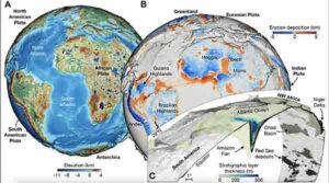
Model by Dr Tristan Salles, School of Geosciences.
Climate, tectonics and time combine to create powerful forces that craft the face of our planet. Add the gradual sculpting of the Earth’s surface by rivers and what to us seems solid as rock is constantly changing.
However, our understanding of this dynamic process has at best been patchy.
Scientists today have published new research revealing a detailed and dynamic model of the Earth’s surface over the past 100 million years.
Working with scientists in France, University of Sydney geoscientists have published this new model in the journal Science.
For the first time, it provides a high-resolution understanding of how today’s geophysical landscapes were created and how millions of tonnes of sediment have flowed to the oceans.
Lead author Dr Tristan Salles from the University of Sydney School of Geosciences, said: “To predict the future, we must understand the past. But our geological models have only provided a fragmented understanding of how our planet’s recent physical features formed.
“If you look for a continuous model of the interplay between river basins, global-scale erosion and sediment deposition at high resolution for the past 100 million years, it just doesn’t exist.
“So, this is a big advance. It’s not only a tool to help us investigate the past but will help scientists understand and predict the future, as well.”
Using a framework incorporating geodynamics, tectonic and climatic forces with surface processes, the scientific team has presented a new dynamic model of the past 100 million years at high resolution (down to 10 kilometres), broken into frames of a million years.
Second author Dr Laurent Husson from Institut des Sciences de la Terre in Grenoble, France, said: “This unprecedented high-resolution model of Earth’s recent past will equip geoscientists with a more complete and dynamic understanding of the Earth’s surface.
“Critically, it captures the dynamics of sediment transfer from the land to oceans in a way we have not previously been able to.”
Dr Salles said that understanding the flow of terrestrial sediment to marine environments is vital to comprehend present-day ocean chemistry.
“Given that ocean chemistry is changing rapidly due to human-induced climate change, having a more complete picture can assist our understanding of marine environments,” he said.
The model will allow scientists to test different theories as to how the Earth’s surface will respond to changing climate and tectonic forces.
Further, the research provides an improved model to understand how the transportation of Earth sediment regulates the planet’s carbon cycle over millions of years.
“Our findings will provide a dynamic and detailed background for scientists in other fields to prepare and test hypotheses, such as in biochemical cycles or in biological evolution.”
Authors Dr Salles, Dr Claire Mallard and PhD student Beatriz Hadler Boggiani are members of the EarthColab Group and Associate Professor Patrice Rey and Dr Sabin Zahirovic are part of the EarthByte Group. Both groups are in the School of Geosciences at the University of Sydney.
The research was undertaken in collaboration with French geoscientists from CNRS, France, Université Lyon and ENS Paris.
Reference:
Tristan Salles, Laurent Husson, Patrice Rey, Claire Mallard, Sabin Zahirovic, Beatriz Hadler Boggiani, Nicolas Coltice, Maëlis Arnould. Hundred million years of landscape dynamics from catchment to global scale. Science, 2023; 379 (6635): 918 DOI: 10.1126/science.add2541
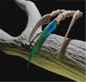
Therizinosaurs claw hooking and pulling trees Credit: Shuyang Zhou for the 3D modelling and functional scenario restoration
Dinosaur claws had many functions, but now a team from the University of Bristol and the Institute of Vertebrate Paleontology and Paleoanthropology (IVPP) in Beijing has shown some predatory dinosaurs used their claws for digging or even for display.
The study focused on two groups of theropod dinosaurs, the alvarezsaurs and therizinosaurs, that had weird claws whose function had been a mystery up to now. It turns out that alvarezsaurs used their rock-pick-like claws for digging, but their close relatives, the giant therizinosaurs, used their overdeveloped, metre-long, sickle-like claws for display.
The new work is led by Zichuan Qin, a PhD student at the University of Bristol and the IVPP. He developed a new, computational approach in biomechanics to identify functions based on detailed comparison with living animals. First, the claws were modelled in three dimensions from CT scans, then modelled for stress and strain using engineering methods, and finally matched to functions of pulling, piercing and digging by comparison with modern animals whose claw functions are known.
“Alvarezsaurs and therizinosaurs are definitely the strangest cousins among dinosaurs,” said Professor Michael Benton, one of Zichuan’s supervisors. “Alvarezsaurs were the tiniest dinosaurs ever, the size of chickens, with stubby forelimbs and robust single claws, but their closest relative, the therizinosaurs, evolved in the exact opposite path.”
“Therizinosaurus is famous for its sickle-like claws, each as long as a samurai sword: Edward Scissor-hands on speed. We all saw Therizinosaurus in ‘Jurassic World’ hitting deer and killing the giant predator Giganotosaurus. However, this is unlikely. These long, narrow claws were too weak for combat.” said Dr Chun-Chi Liao, an expert on therizinosaurs from IVPP who co-authored this study. “Our engineering simulation shows that these claws could not withstand much stress.”
“Not all therizinosaur hand claws were so useless in combat, but most other related species could use their claws as powerful hooking tools when feeding on leaves from the trees.,” Dr Chun-Chi Liao added, “so, we conclude that the largest claws of any animal ever were actually useless in mechanical function, and so must have evolved under sexual selection to be used in display. The adult Therizinosaurus I guess could wave the claws at a competitor and effectively say, ‘look at me, back off’ or wave them around in some way like a peacock can use its tail in display to attract females for mating.”
“Our previous work has shown that alvarezsaurs evolved to become the tiniest dinosaurs by the end of the Cretaceous, and these [dinosaurs] were using their punchy little claws for digging into ant hills and termite mounds. They were ant-eaters,” said Zichuan Qin.
“Our study shows that the early alvarezsaurs, like Haplocheirus from the Jurassic, had multifunctional hands, but they were not good at digging. Their much smaller descendants had the efficient digging hands so they could feast on the Late Cretaceous termites.” added Zichuan Qin.
“Science and technology cannot bring dinosaurs back to life, but advanced computing and engineering techniques can show us how extinct animals lived,” said Professor Emily Rayfield, one of Zichuan’s supervisors, and an expert of dinosaur biomechanics. “Especially for extinct animals like alvarezsaurs and therizinosaurs, they are so bizarre that we even can’t find any living animals like them. Luckily, advanced technology can help us to simulate, on a computer, the functioning of extinct animals using fundamental engineering and biomechanical principles. This study shows very well how selection for function can lead to the emergence of specific, sometime very bizarre, forms.”
Reference:
Zichuan Qin, Chun-Chi Liao, Michael J. Benton, Emily J. Rayfield. Functional space analyses reveal the function and evolution of the most bizarre theropod manual unguals. Communications Biology, 2023; 6 (1) DOI: 10.1038/s42003-023-04552-4
Compass readings that do not show the direction of true north and interference with the operations of satellites are a few of the problems caused by peculiarities of the Earth’s magnetic field.
The magnetic field radiates around the world and far into space, but it is set by processes that happen deep within the Earth’s core, where temperatures exceed 5,000-degress C.
New research from geophysicists at the University of Leeds suggests that the way this super-hot core is cooled is key to understanding the causes of the peculiarities — or anomalies, as scientists call them — of the Earth’s magnetic field.
Dynamo at the centre of the Earth
In the extremely hot temperatures found deep in the Earth, the core is a mass of swirling, molten iron which acts as a dynamo. As the molten iron moves, it generates the Earth’s global magnetic field.
Convective currents keep the dynamo turning as heat flows out of the core and into the mantle, a rock layer that extends 2900 kilometres up to the Earth’s crust.
Research by Dr Jonathan Mound and Professor Christopher Davies, from the School of Earth and Environment at Leeds, has found that this cooling process does not happen in a uniform way across the Earth — and these variations cause anomalies in the Earth’s magnetic field.
Variations in earth’s magnetic field
Seismic analysis has identified that there are regions of the mantle, under Africa and the Pacific for instance, that are particularly hot. Computer simulations by the researchers have revealed that these hot zones reduce the cooling effect on the core — and this causes regional or localised changes to the properties of the magnetic field.
For example, where the mantle is hotter, the magnetic field at the top of the core is likely to be weaker.
And this results in a weaker magnetic field which is projected into space above the South Atlantic, which causes problems for orbiting satellites.
Interference with space technology
Dr Mound, who led the study, said: “One of the things that the magnetic field in space does is deflect charged particles emitted from the sun. When the magnetic field is weaker, this protective shield is not so effective.
“So, when satellites pass over that area, these charged particles can disrupt and interfere with their operations.”
Scientists have known about the anomaly over the South Atlantic since they started monitoring and observing the magnetic field, but it is not known if it is a long-lived feature or something that has happened more recently in the history of the Earth.
As the study at Leeds has revealed, the anomalies are likely to be caused by differences in the rate at which heat is flowing from the Earth’s core into the mantle. Whereabouts in the Earth’s inner structure these heat flow differences happen is likely to dictate how long they could last.
Dr Mound added: “Processes in the mantle happen very slowly, so we can expect the temperature anomalies in the lower mantle will have stayed the same for tens of millions of years. Therefore, we would expect the properties of the magnetic field they create also to have been similar over tens of millions of years.
“But the hotter, outer core is quite a dynamic fluid region. So, the heat flows and the magnetic field properties they cause will probably fluctuate on shorter time scales, perhaps for 100’s to 1000’s of years.”
The paper — Longitudinal structure of Earth’s magnetic field controlled by lower mantle heat flow — is published in Nature Geoscience. When the embargo lifts, it can be downloaded from the Nature Geoscience website.
Reference:
Jonathan E. Mound, Christopher J. Davies. Longitudinal structure of Earth’s magnetic field controlled by lower mantle heat flow. Nature Geoscience, 2023; DOI: 10.1038/s41561-023-01148-9
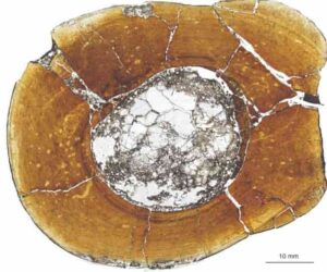
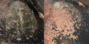
Microsphere from the meteorite: The iron oxide spherule found in the “Domaine du Météore” crater has a core composed of minerals typical for the crater environment and also contains a large number of microdiamonds. Photo: Frank Brenker, Goethe University Frankfurt
With the aim of creating an appealing brand, the name of the ‘Domaine du Météore’ winery near the town of Béziers in Southern France points to a local peculiarity: one of its vineyards lies in a round, 200-metre-wide depression that resembles an impact crater. By means of rock and soil analyses, scientists led by cosmochemist Professor Frank Brenker from Goethe University Frankfurt have now established that the crater was indeed once formed by the impact of an iron-nickel meteorite. In doing so, they have disproved a scientific opinion almost 60 years old, because of which the crater was never examined more closely from a geological perspective.
Countless meteorites have struck Earth in the past and shaped the history of our planet. It is assumed, for example, that meteorites brought with them a large part of its water. The extinction of the dinosaurs might also have been triggered by the impact of a very large meteorite.
Meteorite craters which are still visible today are rare because most traces of the celestial bodies have long since disappeared again. This is due to erosion and shifting processes in Earth’s crust, known as plate tectonics. The “Earth Impact Database” lists just 190 such craters worldwide. In the whole of Western Europe, only three were previously known: Rochechouart in Aquitaine, France, the Nördlinger Ries between the Swabian Alb and the Franconian Jura, and the Steinheim Basin near Heidenheim in Baden-Württemberg (both in Germany). Thanks to millions of years of erosion, however, for laypersons the three impact craters are hardly recognisable as such.
Geologist and cosmochemist Professor Frank Brenker from Goethe University Frankfurt is convinced: the new meteorite crater will now extend the list. While on holiday, the “Domaine du Météore” winery caught his attention. One of its vineyards lies in a round depression about 220 metres in diameter and 30 metres deep, and the proprietors use the scientific hypothesis that it is the impact crater of a meteorite — seemingly long disproved — as a marketing gag for their wine. Although this hypothesis was proposed by several geologists in the 1950s, it was dismissed by acclaimed colleagues a few years later.
Frank Brenker explains: “Craters can form in many ways, and meteorite craters are indeed very rare. However, I found the various other interpretations of how this depression could have formed unconvincing from a geological perspective.” That is why he and his wife collected rock samples for analysis in the labs at Goethe University Frankfurt — and indeed found the first signs of an impact crater. Brenker: “The microanalysis showed that dark-coloured layers in one of the shists, which usually simply comprise a larger percentage of mica, might be shock veins produced by the grinding and fracturing of the rock, which in turn could have been caused by an impact.” He also found evidence of breccia, angular rock debris held together by a kind of “cement,” which can also occur during a meteorite impact.
The following year, Brenker took his colleague Andreas Junge, Professor of Applied Geophysics at Goethe University Frankfurt, and a group of students with him to Southern France to examine the crater in detail. They discovered that Earth’s magnetic field is slightly weaker in the crater than in the surrounding area. This is typical for impact craters because the impact shatters or even melts the rock, which can thus contribute less to Earth’s magnetic field.
With the help of strong magnets attached to a plate, the researchers also found tiny iron oxide spherules of up to one millimetre in diameter. Such spherules had already been found in other impact craters. Later laboratory analysis showed that the ones here also contained nickel-bearing iron and encased a core of minerals typical for the crater environment. In addition, the researchers discovered numerous shock microdiamonds produced through the high pressure during the meteorite’s impact.
Frank Brenker explains: “Such microspheres form either through abrasion of the meteorite in the atmosphere or only upon impact, when a large part of the iron meteorite melts and then reacts with the oxygen in the air. On impact, material shattered at the point of impact might then also be encased. This, together with the lower magnetic field and the other geological and mineralogical finds, allows us to draw hardly any other conclusion: a meteorite did indeed strike here.” This makes the crater very exciting for geological laypeople too, says Brenker, because “every visitor can experience here the immense energies released upon such an impact.”
Microscopic view of a carnivorous dinosaur’s shin bone, showing growth rings that get more closely spaced towards the outside of the bone, indicating that this individual reached adulthood.
The meat-eating dinosaurs known as theropods that roamed the ancient Earth ranged in size from the bus-sized T. rex to the smaller, dog-sized Velociraptor. Scientists puzzling over how such wildly different dinosaur sizes evolved recently found — to their surprise- that smaller and larger theropod dinosaurs like these didn’t necessarily get that way merely by growing slower or faster.
In a new paper published in Science, “Developmental strategies underlying gigantism and miniaturization in non-avialan theropod dinosaurs,” researchers including Ohio University professor Patrick O’Connor and Ph.D. student Riley Sombathy discovered through examining the bones of dinosaurs that there was no relationship between growth rate and body size.
“Most animals are thought to evolve to be larger by growing faster than their ancestors, but this study shows that it’s just as likely that bigger and smaller animals grew for longer or shorter periods of time during growth spurts,” said Michael D. D’Emic, a paleontologist at Adelphi University and lead author of the study.
The bones of many animals, including dinosaurs, slowed or paused growth every year, leaving marks like tree rings that indicate the animal’s age and can be used to estimate the rate of growth. “Rings like these are called cortical growth marks,” said D’Emic. “Widely spaced rings indicate faster growth and narrowly spaced rings tell us that an animal was growing more slowly.”
D’Emic, O’Connor, Sombathy and a team of international researchers measured about 500 such growth rings in about 80 different theropod bones, the two-legged, mostly meat-eating species of dinosaurs closely related to birds.
“We found that there was no relationship between growth rate and size,” said D’Emic. “Some gigantic dinosaurs grew very slowly, slower than alligators do today. And some smaller dinosaurs grew very fast, as fast as mammals that are alive today.” This made sense to co-author Thomas Pascucci, whose graduate thesis contributed to the project: “Extinct animals like dinosaurs inspire awe because of how different they seem from our modern world, but they were animals that grew under similar constraints and environmental factors as those that exist today.”
According to O’Connor, this study opens the door to future investigations of how animals regulate their growth. “Alteration of different growth control mechanisms, at molecular or genetic levels, likely accounts for the range of developmental strategies our team observed in theropod dinosaurs. Future studies of living organisms provide an opportunity to elucidate mechanisms related to the evolution of body size in vertebrates more generally.”
Sombathy hopes to take up some of those investigations, adding “One of the things that interests me most about the results is the apparent decoupling between growth rate and body size. My Ph.D. dissertation will investigate the impacts of growth rate and body size on bone shape and function.”
“This has really important implications because changes in rate versus timing can correlate to many other things, like how many or how large your offspring are, how long you live, or how susceptible to predators you are,” D’Emic added. “Hopefully this research spurs investigations into other groups, both alive and extinct, to see what developmental mechanisms are most important in other types of animals.”
In addition to O’Connor, Sombathy, and D’Emic, the paper was co-authroed by Ignacio Cerda of Consejo Nacional de Investigaciones Científicas y Técnicas (CONICET) and Universidad Nacional de Río Negro in Argentina, David Varricchio of Montana State University; Diego Pol of CONICET-Museo Paleontológico Egidio Feruglio in Argentina, Rodolfo Coria of Museo Carmen Funes in Argentina; and Kristina A. Curry Rogers of Macalester College in Minnesota. The study was funded, in part, by the US National Science Foundation and Adelphi University.
Reference:
Michael D. D’Emic et al. Developmental strategies underlying gigantism and miniaturization in non-avialan theropod dinosaurs. Science, 2023 DOI: 10.1126/science.adc8714
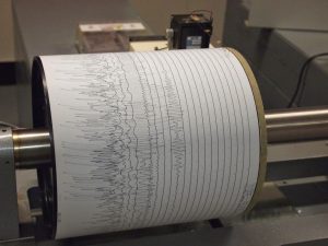
Seismogram being recorded by a seismograph at the Weston Observatory in Massachusetts, USA. Credit: Wikipedia
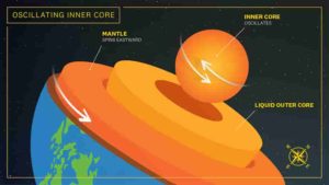
Data captured from seismic waves caused by earthquakes has shed new light on the deepest parts of Earth’s inner core, according to seismologists from The Australian National University (ANU).
By measuring the different speeds at which these waves penetrate and pass through the Earth’s inner core, the researchers believe they’ve documented evidence of a distinct layer inside Earth known as the innermost inner core — a solid “metallic ball” that sits within the centre of the inner core.
Not long ago it was thought Earth’s structure was composed of four distinct layers: the crust, the mantle, the outer core and the inner core. The findings, published in Nature Communications, confirm there is a fifth layer.
“The existence of an internal metallic ball within the inner core, the innermost inner core, was hypothesized about 20 years ago. We now provide another line of evidence to prove the hypothesis,” Dr Thanh-Son Phạm, from the ANU Research School of Earth Sciences, said.
Professor Hrvoje Tkalčić, also from ANU, said studying the deep interior of Earth’s inner core can tell us more about our planet’s past and evolution.
“This inner core is like a time capsule of Earth’s evolutionary history — it’s a fossilised record that serves as a gateway into the events of our planet’s past. Events that happened on Earth hundreds of millions to billions of years ago,” he said.
The researchers analysed seismic waves that travel directly through the Earth’s centre and “spit out” at the opposite side of the globe to where the earthquake was triggered, also known as the antipode. The waves then travel back to the source of the quake.
The ANU scientists describe this process as similar to a ping pong ball bouncing back and forth.
“By developing a technique to boost the signals recorded by densely populated seismograph networks, we observed, for the first time, seismic waves that bounce back-and-forth up to five times along the Earth’s diameter. Previous studies have documented only a single antipodal bounce,” Dr Phạm said.
“The findings are exciting because they provide a new way to probe the Earth’s inner core and its centremost region.”
One of the earthquakes the scientists studied originated in Alaska. The seismic waves triggered by this quake “bounced off” somewhere in the south Atlantic, before travelling back to Alaska.
The researchers studied the anisotropy of the iron-nickel alloy that comprises the inside of the Earth’s inner core. Anisotropy is used to describe how seismic waves speed up or slow down through the material of the Earth’s inner core depending on the direction in which they travel. It could be caused by different arrangement of iron atoms at high temperatures and pressures or preferred alignment of growing crystals.
They found the bouncing seismic waves repeatedly probed spots near the Earth’s centre from different angles. By analysing the variation of travel times of seismic waves for different earthquakes, the scientists infer the crystallised structure within the inner core’s innermost region is likely different to the outer layer.
They say it might explain why the waves speed up or slow down depending on their angle of entry as they penetrate the innermost inner core.
According to the ANU team, the findings suggest there could have been a major global event at some point during Earth’s evolutionary timeline that led to a “significant” change in the crystal structure or texture of the Earth’s inner core.
“There are still many unanswered questions about the Earth’s innermost inner core, which could hold the secrets to piecing together the mystery of our planet’s formation,” Professor Tkalčić said.
The researchers analysed data from about 200 magnitude-6 and above earthquakes from the last decade.
Reference:
Phạm, TS., Tkalčić, H. Up-to-fivefold reverberating waves through the Earth’s center and distinctly anisotropic innermost inner core. Nat Commun, 2023 DOI: 10.1038/s41467-023-36074-2
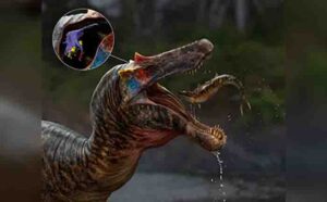
Artist’s impression of Ceratosuchops & orientation of skull endocast. Credit: Anthony Hutchings
Researchers from the University of Southampton and Ohio University have reconstructed the brains and inner ears of two British spinosaurs, helping uncover how these large predatory dinosaurs interacted with their environment.
Spinosaurs are an unusual group of theropod dinosaurs, equipped with long, crocodile-like jaws and conical teeth. These adaptations helped them live a somewhat-aquatic lifestyle that involved stalking riverbanks in quest of prey, among which were large fish. This way of life was very different from that of more familiar theropods, like Allosaurus and Tyrannosaurus.
To better understand the evolution of spinosaur brains and senses, the team scanned fossils of Baryonyx from Surrey and Ceratosuchops from the Isle of Wight. These two are the oldest spinosaurs for which braincase material is known. The huge creatures would have been roaming the planet about 125 million years ago years ago. The braincases of both specimens are well preserved, and the team digitally reconstructed the internal soft tissues that had long rotted away.
The researchers found the olfactory bulbs, which process smells, weren’t particularly developed, and the ear was probably attuned to low frequency sounds. Those parts of the brain involved in keeping the head stable and the gaze fixed on prey were possibly less developed than they were in later, more specialised spinosaurs.
Findings are due to be published in the Journal of Anatomy.
“Despite their unusual ecology, it seems the brains and senses of these early spinosaurs retained many aspects in common with other large-bodied theropods — there is no evidence that their semi-aquatic lifestyles are reflected in the way their brains are organised,” said University of Southampton PhD student Chris Barker, who led the study.
One interpretation of this evidence is that the theropod ancestors of spinosaurs already possessed brains and sensory adaptations suited for part-time fish catching, and that ‘all’ spinosaurs needed to do to become specialised for a semi-aquatic existence was evolve an unusual snout and teeth.
“Because the skulls of all spinosaurs are so specialised for fish-catching, it’s surprising to see such ‘non-specialised’ brains,” said contributing author Dr Darren Naish. “But the results are still significant. It’s exciting to get so much information on sensory abilities — on hearing, sense of smell, balance and so on — from British dinosaurs. Using cutting-edged technology, we basically obtained all the brain-related information we possibly could from these fossils,” Dr Naish said.
Over the last few years, the EvoPalaeo Lab at the University of Southampton has conducted substantial research on new spinosaurs from the Isle of Wight. Ceratosuchops itself was only announced by the team in 2021, and its discovery was followed up by the publication of another new spinosaur — the gigantic White Rock spinosaur — in 2022. The braincase of Ceratosuchops was scanned at the ?-Vis X-ray Imaging Centre at the University of Southampton, home to some of the most powerful CT scanners in the country, and a model of its brain will be on display alongside its bones at Dinosaur Isle Museum in Sandown, on the Isle of Wight.
“This new research is just the latest in what amounts to a revolution in palaeontology due to advances in CT-based imaging of fossils,” said co-author Lawrence M. Witmer, professor of anatomy at the Ohio University Heritage College of Osteopathic Medicine, who has been CT scanning dinosaurs — including Baryonyx — for over 25 years. “We’re now in a position to be able to assess the cognitive and sensory capabilities of extinct animals and explore how the brain evolved in behaviourally extreme dinosaurs like spinosaurs.”
“This new study highlights the significant role British fossils have in our constantly evolving, fast-moving understanding of dinosaurs, and shows how the UK — and the University of Southampton in particular — is at the forefront of spinosaur research,” said Dr Neil Gostling who leads the University of Southampton’s EvoPalaeoLab. “Spinosaurs themselves are one of the most controversial of all dinosaur groups, and this study is a valuable addition to ongoing discussions of their biology and evolution.”
Reference:
Chris Tijani Barker, Darren Naish, Jacob Trend, Lysanne Veerle Michels, Lawrence Witmer, Ryan Ridgley, Katy Rankin, Claire E. Clarkin, Philipp Schneider, Neil J. Gostling. Modified skulls but conservative brains? The palaeoneurology and endocranial anatomy of baryonychine dinosaurs (Theropoda: Spinosauridae). Journal of Anatomy, 2023; DOI: 10.1111/joa.13837
A new study from a University of Chicago scientist suggests there may be a layer of surprisingly fluid rock ringing the Earth, at the very bottom of the upper mantle.
The finding was made by measuring the lingering movement registered by GPS sensors on islands in the wake of a deep earthquake in the Pacific Ocean near Fiji. Published Feb. 22 in Nature, the study demonstrates a new method to measure the fluidity of the Earth’s mantle.
“Even though the mantle makes up the largest part of Earth, there’s still a lot we don’t know about it,” said Sunyoung Park, a geophysicist with the University of Chicago and the lead author on the study. “We think there’s a lot more we can learn by using these deep earthquakes as a way to probe these questions.”
Mantle mysteries
We still know surprisingly little about the Earth beneath our feet. The furthest anyone has managed to dig down is about seven and a half miles before the increasing heat literally melts the drill. Thus scientists have had to use clues like how seismic waves move to infer the different layers that make up the planet, including the crust, mantle, and core.
One thing that has stymied scientists is a precise measurement of how viscous the mantle layer is. The mantle is the layer below the crust. It’s made of rock, but at the intense temperature and pressures at that depth, the rock actually becomes viscous — flowing very slowly like honey or tar.
“We want to know exactly how fast the mantle flows, because that influences the evolution of the entire Earth — it affects how much heat the planet retains for how long, and how the Earth’s materials are cycled over time,” explained Park. “But our current understanding is very limited and includes a lot of assumptions.”
Park thought there might be a unique way to get a measurement of the mantle’s properties by studying the aftermath of very deep earthquakes.
Most of the earthquakes we hear about on the news are relatively shallow, originating in the top crust of the Earth. But occasionally, there are earthquakes that originate deep within the Earth — down to 450 miles below the surface. These earthquakes are not as well-studied as shallower ones, because they’re not as destructive to human settlements. But because they reach down into the mantle, Park thought they might offer a way to understand the behavior of the mantle.
Park and her colleagues looked at one particular such earthquake, which occurred off the coast of Fiji in 2018. The quake was magnitude 8.2, but it was so deep — 350 miles down — that it did not cause any major damage or deaths.
However, when the scientists carefully analyzed the data from GPS sensors on several nearby islands, they found the Earth kept moving — after the earthquake was over.
The data revealed that in the months following the quake, the Earth was still moving, settling in the wake of the disturbance. Even years later, Tonga is still moving slowly down at a rate of about 1 centimeter per year.
“You can think of it like a jar of honey that slowly comes back to level after you dip a spoon in it — except this takes years instead of minutes,” said Park.
This is the first solid observation of the deformation following deep quakes; the phenomenon had been observed before for shallow earthquakes, but experts thought the effect would be too small to be observable for deep earthquakes.
Park and her colleagues used this observation to infer the viscosity of the mantle.
By examining how the Earth deformed over time, they found evidence of a layer about 50-miles thick that is less viscous (that is, “runnier”) than the rest of the mantle, sitting at the bottom of the upper mantle layer. They think this layer may extend around the entire globe.
This low-viscosity layer could explain some other observations by seismologists that suggested there are “stagnant” slabs of rock that don’t move very much, located around the same depth at the bottom of the upper mantle. “It has been hard to reproduce those features with models, but the weak layer found in this study makes it easier to do so,” Park said.
It also has implications for how Earth transports heat, cycles and mixes materials between the crust, core, and mantle over time.
“We’re really excited,” Park said. “There’s a lot more to find out with this technique.”
The other co-authors on the paper were Jean-Philippe Avouac and Zhongwen Zhan of California Institute of Technology and Adriano Gualandi of Italy’s National Institute of Geophysics and Volcanology.
Reference:
Park, S., Avouac, JP., Zhan, Z. et al. Weak upper-mantle base revealed by postseismic deformation of a deep earthquake. Nature, 2023 DOI: 10.1038/s41586-022-05689-8
Image of fruit belonging to Palaeophytocrene chicoensis. The Sierra College Museum of Natural History is the permanent repository for this fossil. Credit: Brian Atkinson.
The discovery of an 80-million-year-old fossil plant pushes back the known origins of lamiids to the Cretaceous, extending the record of nearly 40,000 species of flowering plants including modern-day staple crops like coffee, tomatoes, potatoes and mint.
Brian Atkinson, assistant professor of ecology & evolutionary biology at the University of Kansas and curator of paleobotany at the KU Biodiversity Institute, recently published a study of the fossil plant, named Palaeophytocrene chicoensis, in the peer-reviewed journal Nature Plants.
“This fossil tells us a really diverse group of flowering plants evolved prior to our original understanding,” Atkinson said. “The fossil belongs to a group of lianas, which are woody vines that add structural complexity to rainforests. It shows us this group of flowering plants appeared super early in the fossil record. There’d been some hypotheses that they were around in the Cretaceous period — but no good clear evidence. This is a great indicator that structurally complex, modern-type rainforests may have been around as early as 80 million years ago.”
According to the KU researcher, the fossil fruit sheds new light on a “critical interval” in the history of life on Earth.
“It’s a time when forests are transitioning from being dominated by gymnosperms such as conifers to being dominated by flowering plants,” Atkinson said. “We know these ecological transitions occurred during the Late Cretaceous — but we still need critical pieces of evidence, like how certain ecosystems formed, such as rainforests, which today comprise over half of plant species that are alive today. This fossil shows this diverse group of plants, the lamiids, were older than previously thought, and Cretaceous ecosystems on the west coast of North America may have resembled structurally complex rainforests.”
The well-preserved fossil was unearthed in the 1990s by construction crews building housing near Granite Bay in Sacramento, California. Located in deposits of the Chico Formation tied to the Campanian (fifth of six ages of the Late Cretaceous epoch), the fossil was collected by Richard Hilton and Patrick Antuzzi of Sierra College and housed at their natural history museum.
“I spent seven years looking for these things [Cretaceous lamiids], and I couldn’t find them,” Atkinson said. “I’d been collecting and studying Cretaceous plants on the West Coast to better understand the evolution of flowering plants. Somebody said, ‘Oh, you should check out the Sierra College Museum of Natural History,’ as it wasn’t on my radar to contact them. They gladly had me over to look at their fossil plant collection, and I was just kind of blown away by the diversity of plants that these guys were able to dig up in this housing development.”
It wasn’t until Atkinson saw the fossil plant recovered decades earlier from the construction site that the specimen’s potential significance was understood.
“As I was opening this drawer, I noticed this fruit with really striking patterns on its surface,” the KU researcher said. “I immediately recognized it as belonging to this lamiid family called Icacinaceae, which is well-known in younger, post-Cretaceous deposits after the mass-extinction event. It’s all over the place. But before, there are no clear known fossils that belong to that family. And I thought, ‘Oh my God, this is it!’ You know, this family of plants have just these really striking fruits.”
To confirm his thinking about the fossil, Atkinson needed to take a closer look. He studied the fossil fruit’s structures using light microscopy, which allowed him to generate beautiful photographs of the specimen. By scrutinizing its arrangement of ridges, pits, rows and tubercles, the KU investigator could make comparisons to previously described fossils to place it correctly within its family tree. The work challenged Atkinson because he’d never described a “compression fossil” of its kind.
“I’m used to working on fossils that preserve in a different mode called ‘permineralization,'” Atkinson said. “This is my first paper on a compression fossil, and it was a little bit nerve-wracking, working in a different preservation type than you’re used to. Imaging it is a whole different process — I’m glad this turned out so well.”
After placing the fossil plant within the genus Palaeophytocrene, Atkinson named the species chicoensis after the Chico Formation where it was found.
“I just named it after the formation it was recovered from,” he said. “Part of my job is coming up with scientific names for new species that I describe, but I’m not that creative about it — usually I look up the location where it was discovered. Has that name been taken already?”
If the fossil fruit’s name is humdrum, it’s significance isn’t. The KU researcher said the findings help establish that one of the most diverse flowering plant groups survived the cataclysm that killed the dinosaurs to evolve into thousands of familiar modern species, including vital food crops for humanity.
“My research involves understanding deep time to better reconcile how modern biodiversity came to be — and potentially how it will fare in the future with climate change,” said Atkinson. “I’ve been trying to characterize these evolutionary events of flowering plants in the Cretaceous period, when the diversity of these plants just exploded. The Cretaceous record of lamiids has been hard to establish, but I knew these fossils had to be around. The West Coast of North America is under-sampled for Cretaceous plants compared to the Western Interior and East Coast of North America. By broadening our sampling geographically, we’ll come across more and more plants to help us understand Cretaceous diversification that led to modern biodiversity.”
Reference:
Brian A. Atkinson. Icacinaceae fossil provides evidence for a Cretaceous origin of the lamiids. Nature Plants, 2022; 8 (12): 1374 DOI: 10.1038/s41477-022-01275-y
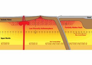
A diagram of the asthenosphere, which aids plate tectonics, where researchers at the UT Austin Jackson School of Geosciences say they detected a global layer of partial melt (shown in speckled red). Credit: Junlin Hua, UT Jackson School of Geosciences
Scientists have discovered a new layer of partly molten rock under the Earth’s crust that might help settle a long-standing debate about how tectonic plates move.
Researchers had previously identified patches of melt at a similar depth. But a new study led by The University of Texas at Austin revealed for the first time the layer’s global extent and its part in plate tectonics.
The research was published Feb. 6, 2023, in the journal Nature Geoscience.
The molten layer is located about 100 miles from the surface and is part of the asthenosphere, which sits under the Earth’s tectonic plates in the upper mantle. The asthenosphere is important for plate tectonics because it forms a relatively soft boundary that lets tectonic plates move through the mantle.
The reasons why it is soft, however, are not well understood. Scientists previously thought that molten rocks might be a factor. But this study shows that melt, in fact, does not appear to notably influence the flow of mantle rocks.
“When we think about something melting, we intuitively think that the melt must play a big role in the material’s viscosity,” said Junlin Hua, a postdoctoral fellow at UT’s Jackson School of Geosciences who led the research. “But what we found is that even where the melt fraction is quite high, its effect on mantle flow is very minor.”
According to the research, which Hua began as a graduate student at Brown University, the convection of heat and rock in the mantle are the prevailing influence on the motion of the plates. Although the Earth’s interior is largely solid, over long periods of time, rocks can shift and flow like honey.
Showing that the melt layer has no influence on plate tectonics means one less tricky variable for computer models of the Earth, said coauthor Thorsten Becker, a professor at the Jackson School.
“We can’t rule out that locally melt doesn’t matter,” said Becker, who designs geodynamic models of the Earth at the Jackson School’s University of Texas Institute for Geophysics. “But I think it drives us to see these observations of melt as a marker of what’s going on in the Earth, and not necessarily an active contribution to anything.”
The idea to look for a new layer in Earth’s interior came to Hua while studying seismic images of the mantle beneath Turkey during his doctoral research.
Intrigued by signs of partly molten rock under the crust, Hua compiled similar images from other seismic stations until he had a global map of the asthenosphere. What he and others had taken to be an anomaly was in fact commonplace around the world, appearing on seismic readings wherever the asthenosphere was hottest.
The next surprise came when he compared his melt map with seismic measurements of tectonic movement and found no correlation, despite the molten layer encompassing almost half the Earth.
“This work is important because understanding the properties of the asthenosphere and the origins of why it’s weak is fundamental to understanding plate tectonics,” said coauthor Karen Fischer, a seismologist and professor at Brown University who was Hua’s Ph.D. advisor when he began the research.
The research was funded by the U.S. National Science Foundation. Collaborating institutions included the UT Oden Institute for Computational Engineering and Sciences and Cornell University.
Reference:
Junlin Hua, Karen M. Fischer, Thorsten W. Becker, Esteban Gazel, Greg Hirth. Asthenospheric low-velocity zone consistent with globally prevalent partial melting. Nature Geoscience, 2023; DOI: 10.1038/s41561-022-01116-9
What once appeared as a fossil of the primitive animal Dickinsonia turned out to be notihng more than a decaying beehive, shown falling off the rock on the right just a couple years later. (Gregory Retallack/Joe Meert)
In 2020, amid the first pandemic lockdowns, a scientific conference scheduled to take place in India never happened.
But a group of geologists who were already on site decided to make the most of their time and visited the Bhimbetka Rock Shelters, a series of caves with ancient cave art near Bhopal, India. There, they spotted the fossil of Dickinsonia¸ a flat, elongated and primitive animal from before complex animals evolved. It marked the first-ever discovery of Dickinsonia in India.
The animal lived 550 million years ago, and the find seemed to settle once and for all the surprisingly controversial age of the rocks making up much of the Indian subcontinent. The find attracted the attention of The New York Times, The Weather Channel and the scientific journal Nature as well as many Indian newspapers.
Only, it turns out, the “fossil” was a case of mistaken identity. The true culprit? Bees.
University of Florida researchers traveled to the site last year and discovered the object had seemingly decayed significantly — quite unusual for a fossil. What’s more, giant bee’s nests populate the site, and the mark spotted by the scientists in 2020 closely resembled the remains of these large hives.
“As soon as I looked at it, I thought something’s not right here,” said Joseph Meert, a UF professor of geology and expert on the geology of the area. “The fossil was peeling off the rock.”
The erstwhile fossil was also lying nearly vertical along the walls of the caves, which didn’t make sense. Instead, Meert says, fossils in this area should only be visible flat on the floor or ceiling of the cave structures.
Meert collaborated on the investigation with his graduate students Samuel Kwafo and Ananya Singha and University of Rajasthan professor Manoj Pandit. They documented the rapid decay of the object and photographed similar remains from nearby beehives. The team published their findings of the mistaken identity Jan. 19 in the journal Gondwana Research, which previously published the report of the serendipitous Dickinsonia fossil find.
Gregory Retallack, professor emeritus at the University of Oregon and lead author of the original paper, says he and his co-authors agree with Meert’s findings that the object is really just a beehive. They are submitting a comment in support of the new paper to the journal.
This kind of self-correction is a bedrock principle of the scientific method. But the reality is that admitting errors is hard for scientists to do, and it doesn’t happen often.
“It is rare but essential for scientists to confess mistakes when new evidence is discovered,” Retallack said in an email.
Correcting the fossil record puts the age of the rocks back into contention. Because the rock formation doesn’t have any fossils from a known time period, dating it can be difficult.
Meert says the evidence continues to point to the rocks being closer to one billion years old. His team has used the radioactive decay of tiny crystals called zircons to date the rocks to that time period. And the magnetic signature of the rocks, which captures information about the Earth’s magnetic field when the rocks formed, closely matches the signatures of formations confidently dated to a billion years ago.
Other scientists have reported findings supporting a younger age. The time period is essential to understand because of its implications for the evolution of life in the area and how the Indian subcontinent formed.
“You might say, ‘Okay, well what’s the big deal if they are 550 million or a billion years old?’ Well, there are lots of implications,” Meert said. “One has to do with the paleogeography at the time, what was happening to continents, where the continents were located, how they were assembled. And it was a period when life was going through a major change, from very simple fossils to more complex fossils.”
“So trying to figure out the paleogeography at the time is very, very important. And in order to figure out the paleogeography, we have to know the age of the rocks,” he said.
Reference:
Joseph G. Meert, Manoj K. Pandit, Samuel Kwafo, Ananya Singha. Stinging News: ‘Dickinsonia’ discovered in the Upper Vindhyan of India not worth the buzz. Gondwana Research, 2023; 117: 1 DOI: 10.1016/j.gr.2023.01.003
The fossilized skull of Coccocephalus wildi, an early ray-finned fish that swam in an estuary 319 million years ago. The fish is facing to the right, with the jaws visible in the lower right portion of the fossil. The eye socket is the circular, bumpy feature above the jaws. This fish would have been 6 to 8 inches long, about the size of a bluegill. Photo credit: Jeremy Marble, University of Michigan News.
The CT-scanned skull of a 319-million-year-old fossilized fish, pulled from a coal mine in England more than a century ago, has revealed the oldest example of a well-preserved vertebrate brain.
The brain and its cranial nerves are roughly an inch long and belong to an extinct bluegill-size fish. The discovery opens a window into the neural anatomy and early evolution of the major group of fishes alive today, the ray-finned fishes, according to the authors of a University of Michigan-led study scheduled for publication Feb. 1 in Nature.
The serendipitous find also provides insights into the preservation of soft parts in fossils of backboned animals. Most of the animal fossils in museum collections were formed from hard body parts such as bones, teeth and shells.
The CT-scanned brain analyzed for the new study belongs to Coccocephalus wildi, an early ray-finned fish that swam in an estuary and likely dined on small crustaceans, aquatic insects and cephalopods, a group that today includes squid, octopuses and cuttlefish. Ray-finned fishes have backbones and fins supported by bony rods called rays.
When the fish died, the soft tissues of its brain and cranial nerves were replaced during the fossilization process with a dense mineral that preserved, in exquisite detail, their three-dimensional structure.
“An important conclusion is that these kinds of soft parts can be preserved, and they may be preserved in fossils that we’ve had for a long time — this is a fossil that’s been known for over 100 years,” said U-M paleontologist Matt Friedman, a senior author of the new study and director of the Museum of Paleontology.
The lead author is U-M doctoral student Rodrigo Figueroa, who did the work as part of his dissertation, under Friedman, in the Department of Earth and Environmental Sciences.
“Not only does this superficially unimpressive and small fossil show us the oldest example of a fossilized vertebrate brain, but it also shows that much of what we thought about brain evolution from living species alone will need reworking,” Figueroa said.
“With the widespread availability of modern imaging techniques, I would not be surprised if we find that fossil brains and other soft parts are much more common than we previously thought. From now on, our research group and others will look at fossil fish heads with a new and different perspective.”
The skull fossil from England is the only known specimen of its species, so only nondestructive techniques could be used during the U-M-led study.
The work on Coccocephalus is part of a broader effort by Friedman, Figueroa and colleagues that uses computed tomography (CT) scanning to peer inside the skulls of early ray-finned fishes. The goal of the larger study is to obtain internal anatomical details that provide insights about evolutionary relationships.
In the case of C. wildi, Friedman was not looking for a brain when he fired up his micro-CT scanner and examined the skull fossil.
“I scanned it, then I loaded the data into the software we use to visualize these scans and noticed that there was an unusual, distinct object inside the skull,” he said.
The unidentified blob was brighter on the CT image — and therefore likely denser — than the bones of the skull or the surrounding rock.
“It is common to see amorphous mineral growths in fossils, but this object had a clearly defined structure,” Friedman said.
The mystery object displayed several features found in vertebrate brains: It was bilaterally symmetrical, it contained hollow spaces similar in appearance to ventricles, and it had multiple filaments extending toward openings in the braincase, similar in appearance to cranial nerves, which travel through such canals in living species.
“It had all these features, and I said to myself, ‘Is this really a brain that I’m looking at?'” Friedman said. “So I zoomed in on that region of the skull to make a second, higher-resolution scan, and it was very clear that that’s exactly what it had to be. And it was only because this was such an unambiguous example that we decided to take it further.”
Though preserved brain tissue has rarely been found in vertebrate fossils, scientists have had better success with invertebrates. For example, the intact brain of a 310-million-year-old horseshoe crab was reported in 2021, and scans of amber-encased insects have revealed brains and other organs. There is even evidence of brains and other parts of the nervous system recorded in flattened specimens more than 500 million years old.
The preserved brain of a 300-million-year-old shark relative was reported in 2009. But sharks, rays and skates are cartilaginous fishes, which today hold relatively few species compared to the ray-finned fish lineage containing Coccocephalus. Early ray-finned fishes like Coccocephalus can tell scientists about the initial evolutionary phases of today’s most diverse fish group, which includes everything from trout to tuna, seahorses to flounder.
There are roughly 30,000 ray-finned fish species, and they account for about half of all backboned animal species. The other half is split between land vertebrates — birds, mammals, reptiles and amphibians — and less diverse fish groups like jawless fishes and cartilaginous fishes.
The Coccocephalus skull fossil is on loan to Friedman from England’s Manchester Museum. It was recovered from the roof of the Mountain Fourfoot coal mine in Lancashire and was first scientifically described in 1925. The fossil was found in a layer of soapstone adjacent to a coal seam in the mine.
Though only its skull was recovered, scientists believe that C. wildi would have been 6 to 8 inches long. Judging from its jaw shape and its teeth, it was probably a carnivore, according to Figueroa.
When the fish died, scientists suspect it was quickly buried in sediments with little oxygen present. Such environments can slow the decomposition of soft body parts.
In addition, a chemical micro-environment inside the skull’s braincase may have helped to preserve the delicate brain tissues and to replace them with a dense mineral, possibly pyrite, Figueroa said.
Evidence supporting this idea comes from the cranial nerves, which send electrical signals between the brain and the sensory organs. In the Coccocephalus fossil, the cranial nerves are intact inside the braincase but disappear as they exit the skull.
“There seems to be, inside this tightly enclosed void in the skull, a little micro-environment that is conducive to the replacement of those soft parts with some kind of mineral phase, capturing the shape of tissues that would otherwise simply decay away,” Friedman said.
Detailed analysis of the fossil, along with comparisons to the brains of modern-fish specimens from the U-M Museum of Zoology collection, revealed that the brain of Coccocephalus has a raisin-size central body with three main regions that roughly correspond to the forebrain, midbrain and hindbrain in living fishes.
Cranial nerves project from both sides of the central body. Viewed as a single unit, the central body and the cranial nerves resemble a tiny crustacean, such as a lobster or a crab, with projecting arms, legs and claws.
Notably, the brain structure of Coccocephalus indicates a more complicated pattern of fish-brain evolution than is suggested by living species alone, according to the authors.
“These features give the fossil real value in understanding patterns of brain evolution, rather than simply being a curiosity of unexpected preservation,” Figueroa said.
For example, all living ray-finned fishes have an everted brain, meaning that the brains of embryonic fish develop by folding tissues from the inside of the embryo outward, like a sock turned inside out.
All other vertebrates have evaginated brains, meaning that neural tissue in developing brains folds inward.
“Unlike all living ray-finned fishes, the brain of Coccocephalus folds inward,” Friedman said. “So, this fossil is capturing a time before that signature feature of ray-finned fish brains evolved. This provides us with some constraints on when this trait evolved — something that we did not have a good handle on before the new data on Coccocephalus.”
Comparisons to living fishes showed that the brain of Coccocephalus is most similar to the brains of sturgeons and paddlefish, which are often called “primitive” fishes because they diverged from all other living ray-finned fishes more than 300 million years ago.
Friedman and Figueroa are continuing to CT scan the skulls of ray-finned fish fossils, including several specimens that Figueroa brought to Ann Arbor on loan from institutions in his home country, Brazil. Figueroa said his doctoral dissertation was delayed by the COVID-19 pandemic but is expected to be completed in summer 2024.
The Nature study includes data produced at U-M’s Computed Tomography in Earth and Environmental Science facility, which is supported by the Department of Earth and Environmental Sciences and the College of Literature, Science, and the Arts.
The other authors of the paper are Sam Giles of London’s Natural History Museum and the University of Birmingham; Danielle Goodvin and Matthew Kolmann of the U-M Museum of Paleontology; and Michael Coates and Abigail Caron of the University of Chicago.
Friedman and Figueroa said the discovery highlights the importance of preserving specimens in paleontology and zoology museums.
“Here we’ve found remarkable preservation in a fossil examined several times before by multiple people over the past century,” Friedman said. “But because we have these new tools for looking inside of fossils, it reveals another layer of information to us.
“That’s why holding onto the physical specimens is so important. Because who knows, in 100 years, what people might be able to do with the fossils in our collections now.”
Reference:
Rodrigo T. Figueroa, Danielle Goodvin, Matthew A. Kolmann, Michael I. Coates, Abigail M. Caron, Matt Friedman, Sam Giles. Exceptional fossil preservation and evolution of the ray-finned fish brain. Nature, 2023; DOI: 10.1038/s41586-022-05666-1
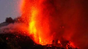
After five decades of dormancy, the Cumbre Vieja volcano on La Palma in the Canary Islands began erupting on Sept. 19, 2021. This image is from October 2021. Credit: Credit: Esteban Gazel/Provided
Cornell University researchers have unearthed precise, microscopic clues to where magma is stored, offering a way to better assess the risk of volcanic eruptions.
In recent years, scientists have used satellite imagery, earthquake data and GPS to search for ground deformation near active volcanoes, but those techniques can be inaccurate in locating the depth of magma storage.
By finding microscopic, carbon dioxide-rich fluids encased in cooled volcanic crystals, scientists can accurately determine — within one hundred meters — where magma is located.
“A fundamental question is where magma is stored in Earth’s crust and mantle,” said Esteban Gazel, professor of engineering and lead author of the study, published in Science Advances. “That location matters because you can gauge the risk of an eruption by pinpointing the specific location of magma, instead of other signals like hydrothermal system of a volcano.”
Gazel notes that speed and precision are essential. “We’re demonstrating the enormous potential of this improved technique in terms of its rapidity and unprecedented accuracy,” he said. “We can produce data within days of the samples arriving from a site, which provides better, near real-time results.”
In volcanic events, magma reaches the Earth’s surface, and it erupts as lava and — depending on how much gas it contains — could be explosive in nature. When deposited as part of the fallout of the eruption, fragmented fine-grained material — called tephra — can be collected and evaluated.
Gazel and doctoral student Kyle Dayton deduced how to use inclusions of carbon dioxide-rich fluids trapped within olivine crystals to precisely indicate depth, as the carbon dioxide density of these inclusions is controlled by pressure.
These fluids can be measured quickly using an instrument to determine — in terms of kilometers — how far down the magma was stored and the depth of the scorching reservoir.
Gazel and Dayton joined a small, elite team of international researchers to study the Cumbre Vieja volcano on La Palma in the Canary Islands. Gazel and Dayton picked through tephra to find crystals, which in turn provide data to improve eruption models and forecasts.
Reference:
Kyle Dayton, Esteban Gazel, Penny Wieser, Valentin R. Troll, Juan Carlos Carracedo, Hector La Madrid, Diana C. Roman, Jamison Ward, Meritxell Aulinas, Harri Geiger, Frances M. Deegan, Guillem Gisbert, Francisco J. Perez-Torrado. Deep magma storage during the 2021 La Palma eruption. Science Advances, 2023; 9 (6) DOI: 10.1126/sciadv.ade7641
Note: The above post is reprinted from materials provided by Cornell University. Original written by Blaine Friedlander, courtesy of the Cornell Chronicle.
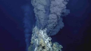
Eggs of deep-sea skates have been discovered near the hottest type of hydrothermal vents, where super-heated water emerges out of the sea floor. These vents, called black smokers, emit dark, sulphurous plumes. Credit: Ocean Exploration Trust
Hydrothermal vents have been identified as a previously undiscovered source of dissolved black carbon in the oceans, furthering the understanding of the role of oceans as a carbon sink.
The ocean is one of the largest dynamic carbon sinks in the world, and is susceptible to increased carbon emissions from human activities. There are even proposals to use the ocean to sequester carbon in an effort to reduce the carbon emissions. However, much of the processes by which the ocean functions as a carbon sink are not fully understood.
Associate Professor Youhei Yamashita and grad student Yutaro Mori at Hokkaido University, along with Professor Hiroshi Ogawa at AORI, The University of Tokyo, have revealed conclusive evidence that hydrothermal vents are a previously unknown source of dissolved black carbon in the deep ocean. Their discoveries were published in the journal Science Advances.
“One of the largest carbon pools on the Earth’s surface is the dissolved organic carbon in the ocean,” explains Ogawa. “We were interested in a portion of this pool, known as dissolved black carbon (DBC), which cannot be utilized by organisms. The source of DBC in the deep sea was unknown, although hydrothermal vents were suspected to be involved.”
The researchers analyzed the distribution of DBC in the ocean basins of the North Pacific Ocean and Eastern South Pacific Ocean, and compared the data with previously reported concentrations of a helium isotope that is associated with hydrothermal vent emissions, as well as oxygen utilization in these areas.
Their findings showed that hydrothermal vents were an important source of DBC in the Pacific Ocean. This hydrothermal DBC is most likely formed due to the mixing of the hot fluids from hydrothermal vents with cold seawater, and is transported over long distances — up to thousands of kilometers away.
“Most importantly, our research indicates that the DBC from hydrothermal vents is an important source of dissolved organic carbon in the deep ocean. In terms of DBC inputs to the ocean, hydrothermal vents may contribute up to half as much DBC as that which is formed by biomass burning or fossil fuel combustion and subsequently transported via rivers or atmospheric deposition,” concluded Yamashita. Further research is required to understand exactly how DBC is formed from hydrothermal vents.
Reference:
Youhei Yamashita, Yutaro Mori, and Hiroshi Ogawa. Hydrothermal-derived black carbon as a source of recalcitrant dissolved organic carbon in the ocean. Science Advances, 2023 DOI: 10.1126/sciadv.ade3807
Meteorites have told Imperial researchers the likely far-flung origin of Earth’s volatile chemicals, some of which form the building blocks of life.
They found that around half the Earth’s inventory of the volatile element zinc came from asteroids originating in the outer Solar System — the part beyond the asteroid belt that includes the planets Jupiter, Saturn, and Uranus. This material is also expected to have supplied other important volatiles such as water.
Volatiles are elements or compounds that change from solid or liquid state into vapour at relatively low temperatures. They include the six most common elements found in living organisms, as well as water. As such, the addition of this material will have been important for the emergence of life on Earth.
Prior to this, researchers thought that most of Earth’s volatiles came from asteroids that formed closer to the Earth. The findings reveal important clues about how Earth came to harbour the special conditions needed to sustain life.
Senior author Professor Mark Rehka?mper, of Imperial College London’s Department of Earth Science and Engineering, said: “Our data show that about half of Earth’s zinc inventory was delivered by material from the outer Solar System, beyond the orbit of Jupiter. Based on current models of early Solar System development, this was completely unexpected.”
Previous research suggested that the Earth formed almost exclusively from inner Solar System material, which researchers inferred was the predominant source of Earth’s volatile chemicals. In contrast, the new findings suggest the outer Solar System played a bigger role than previously thought.
Professor Rehka?mper added: “This contribution of outer Solar System material played a vital role in establishing the Earth’s inventory of volatile chemicals. It looks as though without the contribution of outer Solar System material, the Earth would have a much lower amount of volatiles than we know it today — making it drier and potentially unable to nourish and sustain life.”
The findings are published today in Science.
To carry out the study, the researchers examined 18 meteorites of varying origins — eleven from the inner Solar System, known as non-carbonaceous meteorites, and seven from the outer Solar System, known as carbonaceous meteorites.
For each meteorite they measured the relative abundances of the five different forms — or isotopes — of zinc. They then compared each isotopic fingerprint with Earth samples to estimate how much each of these materials contributed to the Earth’s zinc inventory. The results suggest that while the Earth only incorporated about ten per cent of its mass from carbonaceous bodies, this material supplied about half of Earth’s zinc.
The researchers say that material with a high concentration of zinc and other volatile constituents is also likely to be relatively abundant in water, giving clues about the origin of Earth’s water.
First author on the paper Rayssa Martins, PhD candidate at the Department of Earth Science and Engineering, said: “We’ve long known that some carbonaceous material was added to the Earth, but our findings suggest that this material played a key role in establishing our budget of volatile elements, some of which are essential for life to flourish.”
Next the researchers will analyse rocks from Mars, which harboured water 4.1 to 3 billion years ago before drying up, and the Moon. Professor Rehka?mper said: “The widely held theory is that the Moon formed when a huge asteroid smashed into an embryonic Earth about 4.5 billion years ago. Analysing zinc isotopes in moon rocks will help us to test this hypothesis and determine whether the colliding asteroid played an important part in delivering volatiles, including water, to the Earth.”
This work was funded by the Science and Technology Facilities Council (STFC — part of UKRI) and Rayssa Martins is funded by an Imperial College London Presidents’ PhD Scholarship.
Reference:
Rayssa Martins, Sven Kuthning, Barry J. Coles, Katharina Kreissig, Mark Rehkämper. Nucleosynthetic isotope anomalies of zinc in meteorites constrain the origin of Earth’s volatiles. Science, 2023; 379 (6630): 369 DOI: 10.1126/science.abn1021
Microscopic photograph of a lower jaw from Funcusvermis gilmorei soon after it was recovered during microscopic sorting of sediment from the Thunderstorm Ridge fossil site in the Petrified Forest National Park Paleontology Lab. Photo by Ben Kligman for Virginia Tech.
The smallest of newly found fossils can upend what paleontologists know about our history.
A team of paleontologists from Virginia Tech and the U.S. Petrified Forest National Park, among others, have discovered the first “unmistakable” Triassic-era caecilian fossil — the oldest-known caecilian fossils — thus extending the record of this small, burrowing animal by roughly 35 million years. The find also fills a gap of at least 87 million years in the known historical fossil record of the amphibian-like creature.
The fossil was first co-discovered by Ben Kligman, a doctoral student in the Department of Geosciences, part of the Virginia Tech College of Science, at Arizona’s Petrified Forest National Park during a dig in 2019. Named by Kligman as Funcusvermis gilmorei, the fossil extends the history of caecilians 35 million years back to Triassic Period, roughly 250 million to 200 million years ago.
Prior to this new study, published today in the journal Nature, only 10 fossil caecilian occurrences were known, dating back to the Early Jurassic Period, about 183 million years ago. However, previous DNA studies estimated evolutionary origins of caecilians back to the Carboniferous or Permian eras, some 370 million to 270 million years ago, according to Kligman, marking that 87-million-year gap. However, no such fossils had been found.
“The discovery of the oldest caecilian fossils highlights the crucial nature of new fossil evidence. Many of the biggest outstanding questions in paleontology and evolution cannot be resolved without fossils like this,” said Kligman, who previously discovered a 220-million-year-old species of cynodont or stem-mammal, a precursor of modern-day mammals. “Fossil caecilians are extraordinarily rare, and they are found accidentally when paleontologists are searching for the fossils of other more common animals. Our discovery of one was totally unexpected, and it transformed the trajectory of my scientific interests.”
The discovery of the fossils was made in 2019 by Kligman and Petrified Forest National Park student intern Xavier Jenkins, now a Ph.D. student at Idaho State University, while the duo was processing fossiliferous sediment from the park’s nicknamed Thunderstorm Ridge via a microscope. Funcusvermis was found in a layer of the Chinle Formation dated to approximately 220 million years ago, when Arizona was positioned near the equator at the central part of the supercontinent Pangaea, Kligman said. This region at the time was subject to a hot, humid climate. Today, Arizona is still hot, but has low humidity.
“Seeing the first jaw under the microscope, with its distinctive double row of teeth, sent chills down my back,” Kligman said. “We immediately knew it was a caecilian, the oldest caecilian fossil ever found, and a once-in-a-lifetime discovery.”
Previous to this find, the 87-million-year gap in the fossil record hid the early evolutionary history of caecilians, leading to a decades-long debate amongst scientists over the relationships of caecilians to their amphibian relatives, frogs and salamanders.
“Funcusvermis extends the humid equatorial pattern of occurrence seen in all known fossil and living caecilians, suggesting that the biogeographic history of caecilians has been guided by restriction to these ecological settings, likely due to physiological constraints linked to humidity, and constrained by the drift of continental plates into and out of the humid-equatorial zone after the fragmentation of Pangaea,” Kligman said.
Modern caecilians are limbless amphibians with cylindrical bodies with a compact, bullet-shaped skull that helps them burrow underground. Now exclusively home to South and Central America, Africa, and southern Asia, caecilians spend their lives burrowing in leaf-litter or soil searching for prey such as worms and insects. This underground existence has made studying caecilians difficult for scientists. Kligman, tongue in cheek, describes modern caecilians as an “eyeless sock puppet with the body of a worm.”
Funcusvermis actually shares skeletal features related more with early frog and salamander fossils, strengthening evidence for a shared origin and close evolutionary relationship between caecilians and these two groups. Funcusvermis also shares skeletal features with an ancient group of amphibians known to paleontologists as dissorophoid temnospondyls. Kligman adds, “Unlike living caecilians, Funcusvermis lacks many adaptations associated with burrowing underground, indicating a slower acquisition of features associated with an underground lifestyle in the early stages of caecilian evolution.”
Name that tune
Now, here’s the fun part: The genus name ‘Funcusvermis’ was inspired by the Ohio Players’ 1972 song “Funky Worm” from their album Pleasure, a favorite song of the authors that was often played while excavating fossils at Thunderstorm Ridge. ‘Funcus’ is derived from the Latinized form of the English word Funky for the upbeat, rhythmic form of dance music, while ‘vermis’ is derived from the Latin word for worm. (It’s an excellent song, by the way. Instant earworm, so to speak.)
The species name, gilmorei, honors Ned Gilmore, the collections manager at the Academy of Natural Sciences of Philadelphia’s Drexel University. (Kligman is from Philadelphia and volunteered with Gilmore’s herpetology wet collection as an undergraduate student. “He was an important mentor who helped inspire my interest in fossils and amphibians,” Kligman said.)
Co-authors on the study include Michelle Stocker, an assistant professor, and Sterling Nesbitt, an associate professor, in the Virginia Tech Department of Geosciences and members of the Global Change Center that is part of the Fralin Life Sciences Institute. Other authors include Adam Marsh, lead paleontologist; Matthew Smith, museum curator; and William Parker, chief of science and resource management, all at the Petrified Forest National Park; and Bryan Gee, postdoctoral fellow at the University of Washington’s Burke Museum and Department of Biology.
“As the eponymous song says, it’s the funkiest worm in the world,” Marsh quipped.
Stocker added, “What we collect really determines what we can say about which animals that were present, how many of them there were, and what they looked like. Without using these methods for fossil collection and analysis we would be missing out on knowing so many important aspects of this Triassic ecosystem. Now that we have a search image of what bones to look for and how to look for them, it will be exciting to see what other fossil localities preserve these early lissamphibians.”
Nesbitt said finds such as this can reset the game board on paleontology, in the best sense of the phrase. “This find clearly demonstrates that some fossils that you can barely see can greatly change our understanding of entire groups that you can see today,” he said.
What’s happened since 2019
At the Petrified Forest National Park, where the initial discovery was found in 2019, the lower jaws of at least 70 individuals of Funcusvermis have been recovered as of summer 2022, making the area “the most abundant fossil caecilian-producing bonebed ever discovered,” Kligman said.
Only a handful of bones of Funcusvermis have been found, including upper and lower jaws, a vertebra, and part of a hind-limb, Kligman said. All of the found bones were disarticulated, not as complete skeletons. Without complete skeletons, Kligman and his fellow researchers cannot exactly determine the body length of Funcusvermis, but inferences from isolated elements, such as the lower jaw being less than a quarter of an inch long, indicate that Funcusvermis was a tiny animal.
“Since its discovery in 2017, the Thunderstorm Ridge site has produced a diverse assemblage of over 60 animals ranging from freshwater sharks to dinosaurs,” Kligman said. “Several other new species discovered at this site have been recently described. Many other new species from this site are currently under study and will be published in upcoming years.”
In other words, fully expect more upending of what paleontologists know about the history of fossils.
Reference:
Ben T. Kligman, Bryan M. Gee, Adam D. Marsh, Sterling J. Nesbitt, Matthew E. Smith, William G. Parker, Michelle R. Stocker. Triassic stem caecilian supports dissorophoid origin of living amphibians. Nature, 2023; DOI: 10.1038/s41586-022-05646-5
Earth’s inner core, a hot iron ball the size of Pluto, has stopped spinning faster than the planet’s surface and might now be rotating slower than it, research suggested on Monday.
Roughly 5,000 kilometers (3,100 miles) below the surface we live on, this “planet within the planet” can spin independently because it floats in the liquid metal outer core.
Exactly how the inner core rotates has been a matter of debate between scientists—and the latest research is expected to prove controversial.
What little is known about the inner core comes from measuring the tiny differences in seismic waves—created by earthquakes or sometimes nuclear explosions—as they pass through the middle of the Earth.
Seeking to track the inner core’s movements, new research published in the journal Nature Geoscience analyzed seismic waves from repeating earthquakes over the last six decades.
“We believe the inner core rotates, relative to the Earth’s surface, back and forth, like a swing,” the study’s authors, Xiaodong Song and Yi Yang of China’s Peking University, told AFP.
“One cycle of the swing is about seven decades,” the authors said.
The inner core started rotating slightly faster than the rest of the planet in the early 1970s, the study said.
But it had been slowing down before coming in sync with Earth’s rotation around 2009, it added.
There has been a “negative trend” since, the study said, meaning the inner core is now rotating slower than the surface.
The researchers predicted the next change would occur in the mid-2040s.
They said this rotation timeline roughly lines up with changes in what is called the “length of day”—small variations in the exact time it takes Earth to rotate on its axis.
Stuck in the middle
So far there is little to indicate that what the inner core does has much effect on surface dwellers.
But the researchers said they believed there were physical links between all Earth’s layers, from the inner core to the surface.
“We hope our study can motivate some researchers to build and test models which treat the whole Earth as an integrated dynamic system,” they said.
Experts not involved in the study expressed caution about its findings, pointing to several other theories and warning that many mysteries remain about the center of the Earth.
“This is a very careful study by excellent scientists putting in a lot of data,” said John Vidale, a seismologist at the University of Southern California.
“(But) none of the models explain all the data very well in my opinion,” he added.
Vidale published research last year suggesting that the inner core oscillates far more quickly, swinging around every six years or so.
His work was based on seismic waves from two nuclear explosions in the late 1960s and early 1970s.
That timeframe is around the point when Monday’s research says the inner core was last in sync with Earth’s rotation—which Vidale called “kind of a coincidence”.
Geophysicists ‘divided’
Another theory—which Vidale said has some good evidence supporting it—is that the inner core only moved significantly between 2001 to 2013 and has stayed put since.
Hrvoje Tkalcic, a geophysicist at the Australian National University, has published research suggesting that the inner core’s cycle is every 20 to 30 years, rather than the 70 proposed in the latest study.
“These mathematical models are most likely all incorrect because they explain the observed data but are not required by the data,” Tkalcic said.
“Therefore, the geophysical community will be divided about this finding and the topic will remain controversial.”
He compared seismologists to doctors “who study the internal organs of patients’ bodies using imperfect or limited equipment”.
Lacking something like a CT scan, “our image of the inner Earth is still blurry”, he said, predicting more surprises ahead.
That could include more about a theory that the inner core might have yet another iron ball inside it—like a Russian doll.
“Something’s happening and I think we’re gonna figure it out,” Vidale said. “But it may take a decade.”
Reference:
Yi Yang et al, Multidecadal variation of the Earth’s inner-core rotation, Nature Geoscience (2023). DOI: 10.1038/s41561-022-01112-z
Rotation of the Earth’s inner core changes over decades and has come to near-halt, Nature Geoscience (2023). DOI: 10.1038/s41561-022-01113-y
Correction note (January 25, 2023): Corrects throughout story dated January 23 to say that core’s rotation has slowed compared to Earth’s surface, not changed direction.
Note: The above post is reprinted from materials provided by AFP.
The new study in Geophysical Research Letters shows a previously undiscovered change in tectonic plate thickness across the Denali Fault in Alaska impacts where it is located, shedding light on how major faults and earthquakes occur. Credit: Isabella Gama and Karen Fischer.
When the rigid plates that make up the Earth’s lithosphere brush against one another, they often form visible boundaries, known as faults, on the planet’s surface. Strike-slip faults, such as the San Andreas Fault in California or the Denali Fault in Alaska, are among the most well-known and capable of seriously powerful seismic activity.
Studying these faults can help geoscientists not only better understand the process of plate tectonics, which helped form the planet’s continents and mountains, but also better model their earthquake hazards. The problem is that most studies on these types of faults are (quite literally) shallow, looking only at the upper layer of the Earth’s crust where the faults form.
New research led by Brown University seismologists digs deeper into the Earth, analyzing how the part of the fault that’s near the surface connects to the base of the tectonic plate in the mantle. The scientists found that changes in how thick the plate is and how strong it is deep into the Earth play a key role in the location of Alaska’s Denali Fault, one of the world’s major strike-slip faults.
The findings begin to fill major gaps in understanding about how geological faults behave and appear as they deepen, and they could eventually help lead future researchers to develop better earthquake models on strike-slip faults, regions with frequent and major earthquakes.
“That means when geoscientists model earthquake cycles, they’ll have new information on the strength of the deeper rocks that would be useful for understanding the dynamics of these faults, how stress will build up on them, and how they might rupture in the future,” said Karen M. Fischer, a study author and geophysics professor at Brown.
The study, published in Geophysical Research Letters, was led by Brown alumna Isabella Gama, who completed the work last year while she was a Ph.D. student in the University’s Department of Earth, Environmental and Planetary Sciences. The paper focuses primarily on the Denali Fault, a 1,200-mile-long fault that arcs across most of Alaska and some of Western Canada. In 2002, it was the site of a magnitude 7.9 earthquake that sloshed lakes as far away as Seattle, Texas and New Orleans.
The researchers used new data from a cutting-edge network of seismic stations to create a new 3D model of seismic wave velocities throughout Alaska. With this innovative tool, the researchers discovered changes in the thickness and internal strength of the tectonic plate that Alaska sits on. The model shows how these changes in plate strength, that extend as deeply as about 80 kilometers, feed back into the mechanics of where the Denali fault line is produced.
Geoscientists have known that the Earth’s crust that is south of the Denali Fault is thicker, while north of the fault, the crust is thinner. What’s been less clear is data on changes in the deeper, mantle portion of the plate.
In the new study, the researchers documented for what is believed to be the first time that the Denali Fault forms because of an increase in strength on the northern side of the fault that goes all the way through the upper plate.
They found that when they looked at the base of the plate or lithosphere, the lithosphere is stronger and thicker on the northern side of the fault vs. being much thinner and weaker on the southern side. The deeper part of the plate to the north can act almost as a backstop, they describe in the paper. They conclude that the fault at the surface formed and stayed at the edge of this thicker, stronger lithosphere.
“There has been this controversy that faults in the shallower brittle crust wouldn’t connect to structures in the deepest part of the plate, but here we show that they do,” Gama said. “And this could mean a variety of things. For example, it means that we could expect earthquakes occurring deeper than previously thought for strike-slip faults such as the Denali fault, and that plate motions could occur on clear boundaries that extend from shallow faults all the way to the base of the plate.”
The scientists’ avenue of research opened up when IRIS, a research consortium funded by the National Science Foundation and dedicated to exploring the Earth’s interior, deployed the EarthScope Transportable Array in Alaska from 2014 to 2021. The advanced technology — a large collection of seismographs installed temporarily at sites across the U.S. — gave researchers like Gama and Fischer the capability to measure properties of the deeper crust and mantle that hadn’t been possible before.
The researchers next plan to look closer at other strike-slip fault lines around the world to see if they can find similar variations in the structure of tectonic plates the deeper they go. Other well-known strike-slip fault lines include the San Andreas Fault in California and the Anatolian Fault in Turkey, both of which have caused major earthquakes in the past. The San Andreas Fault, for instance, caused the earthquake of 1906 in San Francisco that killed thousands.
“We hope that projects such as the EarthScope Transportable Array will continue to receive support so that we can obtain higher-resolution images of the Earth’s interior from anywhere on the planet,” Gama said. “We hope to gain a better understanding of plate tectonics by using these images and will begin by investigating how other strike-slip faults appear and behave, looking for parallels with Alaska. This information could then be fed back into improving models for how earthquakes occur.”
This research was supported by the NSF EarthScope Program.
Reference:
Isabella Gama, Karen M. Fischer, Colleen A. Dalton, Zachary Eilon. Variations in Lithospheric Thickness Across the Denali Fault and in Northern Alaska. Geophysical Research Letters, 2022; 49 (24) DOI: 10.1029/2022GL101256
A view of Kīlauea’s summit lava lake. The lava lake is contained within a crater, which is set within the larger Halema‘uma‘u Crater. New research aims to understand the activity that led to the eruption in 2018 in Kīlauea’s lower East Rift Zone. Credit: USGS
In 2015, a submarine volcano in the South Pacific erupted, forming the Hunga Tonga Hunga Ha’apai island, destined to a short, seven-year life. A research team led by the University of Colorado Boulder and Cooperative Institute for Research in Environmental Sciences (CIRES) jumped on the rare opportunity to study the early microbial colonizers of a newly formed landmass and to their surprise, the researchers discovered a unique microbial community that metabolizes sulfur and atmospheric gases, similar to organisms found in deep sea vents or hot springs.
“These types of volcanic eruptions happen all over the world, but they don’t usually produce islands. We had an incredibly unique opportunity,” said Nick Dragone, CIRES PhD student and lead author of the study published this month in mBio. “No one had ever comprehensively studied the microorganisms on this type of island system at such an early stage before.”
“Studying the microbes that first colonize islands provides a glimpse into the earliest stage of ecosystem development — before even plants and animals arrive,” said Noah Fierer, CIRES fellow, professor of ecology and evolutionary biology at CU Boulder and corresponding author on the study.
A multi-institutional team of researchers on the ground collected soil samples from the island, then shipped them to CU Boulder’s campus. Dragone and Fierer could then extract and sequence DNA samples from the samples.
“We didn’t see what we were expecting,” said Dragone. “We thought we’d see organisms you find when a glacier retreats, or cyanobacteria, more typical early colonizer species — but instead we found a unique group of bacteria that metabolize sulfur and atmospheric gases.”
And that wasn’t the only unexpected twist in this work: On January 15, 2022, seven years after it formed, the volcano erupted again, obliterating the entire landmass in the largest volcanic explosion of the 21st century. The eruption completely wiped out the island and eliminated the option for the team to continue monitoring their site.
“We were all expecting the island to stay,” said Dragone. “In fact, the week before the island exploded we were starting to plan a return trip.”
However, the same fickle nature of the Hunga Tonga Hunga Ha’apai (HTHH) that made it explode also explains why the team found such a unique set of microbes on the island. Hunga Tonga was volcanically formed, like Hawaii.
“One of the reasons why we think we see these unique microbes is because of the properties associated with volcanic eruptions: lots of sulfur and hydrogen sulfide gas, which are likely fueling the unique taxa we found,” Dragone said. “The microbes were most similar to those found in hydrothermal vents, hot springs like Yellowstone, and other volcanic systems. Our best guess is the microbes came from those types of sources.”
The expedition to HTHH required close collaboration with members of the government of the Kingdom of Tonga, who were willing to work with researchers to collect samples from land normally not visited by international guests. Coordination took years of work by collaborators at the Sea Education Association and NASA: a Tongan observer must approve and oversee any sample collection that takes place within the Kingdom.
“This work brought in so many people from around the world, and we learned so much. We are of course disappointed that the island is gone, but now we have a lot of predictions about what happens when islands form,” said Dragone. “So if something formed again, we would love to go there and collect more data. We would have a game plan of how to study it.”
Reference:
Nicholas B. Dragone, Kerry Whittaker, Olivia M. Lord, Emily A. Burke, Helen Dufel, Emily Hite, Farley Miller, Gabrielle Page, Dan Slayback, Noah Fierer. The Early Microbial Colonizers of a Short-Lived Volcanic Island in the Kingdom of Tonga. mBio, 2023; DOI: 10.1128/mbio.03313-22