back to top
27.8 C
New York
Monday, April 21, 2025
Home Blog Page 17

Researchers discover previously unknown mineralogy of the deep Earth

Earth, core, mantle
Earth’s Interior

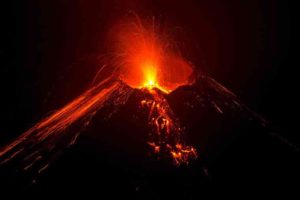
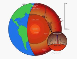
What is the structure of the Earth? For starters, it consists of several layers: the crust, the upper and lower mantle, and the core. The mantle makes up most of our planet’s volume—84%. The lower mantle represents 55% of the Earth’s volume—it is also hotter and denser than the upper mantle.

The lower mantle has played an important role in the Earth’s evolution, including how Earth has cooled over billions of years, how materials have been circulated, and how water is stored and transported from/to the deep interior over a geologic time scale.

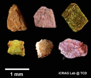
For more than seven decades, the mineralogy of the lower mantle has been studied extensively. The decades of studies, including laboratory experiments, computational simulations, and the study of inclusions in deep diamonds, led to the conclusion that the lower mantle consists of three main minerals: bridgmanite, ferropericlase, and davemaoite.

In a study recently published in Nature, a team of scientists—including Byeongkwan Ko, former Ph.D. student at ASU, now a postdoctoral researcher at Michigan State University, and Sang-Heon Dan Shim, Professor at the School of Earth and Space Exploration and a Navrotsky Professor of Materials Research at ASU have completed a new high-pressure experiment employing some different styles of heating to reveal an additional mineral residing in the lower mantle.

Among these three main minerals, two minerals bridgmanite and davemaoite have both so-called perovskite-type crystal structures. This structure is also widely known in physics, chemistry, and materials engineering, as some materials with the perovskite-type structure have shown superconductivity.

At shallow depths, minerals with similar crystal structures often merge and become single minerals, typically under a high-temperature environment. For example, mineral diopside has both calcium and magnesium, and is stable in the crust. Despite the structural similarity, however, existing studies have shown that davemaoite, rich in calcium, and bridgmanite, rich in magnesium, remain separate throughout the lower mantle.

“Why davemaoite and bridgmanite do not merge to one despite the fact that they have very similar atomic-scale structures? This question has fascinated researchers over two decades,” said Shim. “Many attempts have been made to find conditions where these two minerals merge, yet the answer from experiments has been consistently two separate minerals. This where we felt we need some fresh new ideas in experiments.”

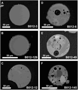
The new experiment was an opportunity for the research group to try various heating techniques to compare methods. Instead of increasing temperature slowly in conventional high-pressure experiments, they increased temperature very fast to the high temperature related to the lower mantle, reaching 3000–3500 F within a second. The reason for this was that once two perovskite-structured minerals form it becomes very difficult for them to merge even if they enter into temperature conditions where a single perovskite mineral should be stable.

By heating the samples fast to target temperatures, Ko and Shim were able to avoid formation of two perovskite-structured minerals at low temperatures. Once they reach the temperature of the lower mantle, they monitor what minerals form for 15–30 min using X-ray beams at the Advanced Photon Source. They found that only single perovskite mineral forms, unexpected from the previous experiments. They found that at sufficiently high temperatures greater than 3500 F, davemaoite and bridgmanite become a single mineral in the perovskite-type structure.

“It has been believed that a large size difference between calcium and magnesium, the major cations of davemaoite and bridgmanite, respectively, should hinder these two minerals from merging,” said Ko. “But our study shows that they can overcome such difference in hot environments.”

The experiments suggest that the deeper lower mantle with sufficiently high temperature should have a mineralogy different from the shallower lower mantle. Because the mantle was much warmer in early Earth, the group’s new results indicate that most of the lower mantle had a single perovskite-structured mineral then, which means the mineralogy differed from the present-day lower mantle.

This new observation has a range of substantial impacts on our understanding of the deep Earth. Many seismic observations have shown that the deeper lower mantle properties are different from the shallower lower mantle. The changes are reported to be gradual. The merge of bridgmanite and davemaoite is shown to be gradual in the research group’s experiments.

Also, the properties of a rock with three main minerals, bridgmanite, ferropericlase, and davemaoite, does not match well with the properties of the deeper lower mantle. Ko and collaborators predict that these unresolved problems can be explained by a merge of bridgmanite and davemaoite to a new single perovskite-structured mineral.

Reference:
Byeongkwan Ko et al, Calcium dissolution in bridgmanite in the Earth’s deep mantle, Nature (2022). DOI: 10.1038/s41586-022-05237-4

Note: The above post is reprinted from materials provided by Arizona State University

How old is California’s Yosemite Valley?

In 2010, two of the study's authors—David Shuster of UC Berkeley (left) and Yosemite Park geologist Greg Stock (right)—collected rock samples from the rim of Yosemite Valley, where the granite has eroded only slowly over the last 50 million years. In the distance is the upper Merced River valley. Former UC Berkeley graduate student Johnny Webb is at center. Credit: Kurt Cuffey, UC Berkeley
In 2010, two of the study’s authors—David Shuster of UC Berkeley (left) and Yosemite Park geologist Greg Stock (right)—collected rock samples from the rim of Yosemite Valley, where the granite has eroded only slowly over the last 50 million years. In the distance is the upper Merced River valley. Former UC Berkeley graduate student Johnny Webb is at center. Credit: Kurt Cuffey, UC Berkeley

First-time visitors to Yosemite Valley gape in awe at the sheer granite wall of El Capitan and the neatly sliced face of Half Dome, aware, perhaps vaguely, that rain and glaciers must have taken a long time to cut and sculpt that landscape. But how long?

Did it all start 50 million years ago, when the granite through which the valley cuts was first exposed to the elements? Was it 30 million years ago, when data suggest canyons in the southern Sierra Nevada began to form? Did the valley only begin to form after the Sierra tilted toward the west some 5 million years ago, or was it mostly due to glaciers that formed in a cooling climate 2 to 3 million years ago?

Geologists from the University of California, Berkeley, employed a novel technique of rock analysis to get a more precise answer, and concluded that much of Yosemite Valley’s impressive depth was carved since 10 million years ago, and most likely even more recently — over the past 5 million years. This shaves about 40 million years off the oldest estimates.

Rivers performed the initial carving in a preexisting shallow valley, they determined, and then both rivers and ice contributed recently.

While the scientists are unable to be more precise, the new estimate is the first to be based on an experimental study of the granite rocks in and near Yosemite, rather than on inferences based on what was going on elsewhere in the Sierra Nevada.

“Yosemite Valley is one of the most famous topographic features on the planet,” said glaciologist Kurt Cuffey, UC Berkeley professor of geography and of earth and planetary science. “And of course, if you go to Yosemite Park and read the signage, they will give you numbers for when it became a deep canyon. But up until this project, every single claim about how old this valley is, when it formed a deep canyon, was just based on assumptions and speculation.”

Yosemite National Park geologist Greg Stock admits that the story told about the origin of the park’s iconic granite topography has been a little vague, because geologists still do not agree about what has happened since the Sierra’s signature granite formed underground between about 80 and 100 million years ago, up to 10 kilometers (6 miles) under a mountain range that looked a lot different than it does today.

“We know that the Sierra was a high mountain range 100 million years ago, when the granite was forming at depth. It was a chain of volcanoes that might have looked a bit like the Andes Mountains in South America,” Stock said. “The question really is whether the elevation has just been coming down through erosion since that time or whether it came down some and then was uplifted again more recently. At this point, based on studies I’ve done for most of my career and supported by this study, I see a lot of evidence for recent uplift happening sometime in the last 5 million years.”

That uplift, which happened at the same time that earthquake faulting in the eastern Sierra Nevada created an escarpment several kilometers high, steepened the western slopes and rivers, causing them to incise valleys more quickly.

Cuffey, UC Berkeley geochemist David Shuster and their colleagues, including Stock, published the findings this week in the journal Geological Society of America Bulletin.

Rock cooldown

Shuster, a professor of earth and planetary science, developed a technique 15 years ago that he thought at the time might shed light on the origins of the valley, something that has fascinated both him and Cuffey since they first saw Yosemite as kids. Shuster, a California native, has visited it since early childhood. Cuffey, from central Pennsylvania, made his first trip to the park at the age of 15.

Much of what they remember learning is that the valley was carved by glaciers, giving short shrift to what happened before Ice Age glaciers arrived in the Pleistocene some 2.5 million years ago.

“What I learned from the signage in the valley when I was a kid wasn’t quite right, given what the scientific literature said at the time. Nevertheless, the topography has been interpreted to be significantly modified by ice,” Shuster said. “How to quantify that with geochronological tools, rather than just make up a story about it based on geomorphology, is one thing we were trying to do here.”

Shuster’s technique, called helium-4/helium-3 thermochronometry, reconstructs the temperature history of a sample of rock based on the spatial distribution of natural helium-4 in minerals, which is measured by comparison to an artificially-produced uniform distribution of helium-3. Because temperature increases with depth underground, the temperature history can tell when a rock was uncovered as the landscape eroded.

“The temperature of the rock is a function of the surface lowering down into it,” Shuster said. “It’s very analogous to removing a down comforter — the rock beneath it progressively gets colder. This progression through time with the rock cooling is what we get from the geochemistry and thermochronometry.”

The expectation is that granite bedrock exposed on the broad uplands of the Sierra should show a long history of cool surface temperatures, since they’ve been exposed for tens of millions of years longer than bedrock more recently exposed on the floor of Tenaya Canyon, which feeds into Yosemite Valley from the northeast.

The experiments, conducted at the Berkeley Geochronology Center, indicated that, while rock from the uplands has been close to the surface for about 50 million years, bedrock at the bottom of Tenaya Canyon has been exposed much more recently. The temperature history of the rock obtained from the bottom of Tenaya Canyon — from an exposed area of bedrock at the base of Half Dome — indicates that it was more than a kilometer underground 10 million years ago, and most likely only 5 million years ago. This means that a kilometer of rock was eroded away since that time.

“This upland surface that people are familiar with from parts of the Tioga Road and Tuolumne Meadows — that’s a very old landscape,” said Cuffey, who is the Martin Distinguished Chair in Ocean, Earth and Climate Science. “The question is: What about the deep canyon? Is that also very old, or is it relatively young? And what we found in our study, our big contribution, is that it’s fairly young. The best guess for the timing is in the last 3 to 4 million years, but maybe as far back as 10 million years for the start of the rapid incision.”

Bedrock studies

The geologists collected samples of granite bedrock from nearby highlands and the bottom of Tenaya Canyon, but not from the bedrock bottom of Yosemite Valley itself, which lies buried under about 500 meters (1/3 mile) of sediment that today forms the valley floor. But since the two formed at the same time, one can infer the timing of the formation of Yosemite Valley from the time of the scouring of Tenaya Canyon.

“The brief history of Yosemite Valley would be that there was some kind of valley in place for tens of millions of years — a river-carved canyon associated with the ancient Sierra Nevada. And then, in the last 5 million years or so, renewed uplift of the range through westward tilting caused rivers to steepen and deepen the canyons that they were in,” Stock said. “So, that probably carved out more of Yosemite Valley and may have started forming Tenaya Canyon. And then in the last 2 to 3 million years, as the climate cooled and glaciers came down through Tenaya Canyon and into Yosemite Valley, they further sculpted the rock, deepening those valleys. And in the case of Yosemite Valley, widening it out considerably. So, there’s some component of an old Yosemite Valley. But I think this recent work shows that much more of that topography is younger, rather than older.”

Stock, who has held the position of park geologist for 17 years and is the park’s first geologist, said the new study will revise how the park tells the geological history of Yosemite Valley.

“The timing of this new study is perfect in the sense that, over the next several years, we’re hoping to completely redo the Geology Hut displays at Glacier Point. I’m very excited to include these new results in those displays,” he said. “It’s a perfect place to tell that story, because there’s a view straight up Tenaya Canyon.”

Reference:
Kurt M. Cuffey, Alka Tripathy-Lang, Matthew Fox, Greg M. Stock, David L. Shuster. Late Cenozoic deepening of Yosemite Valley, USA. GSA Bulletin, 2022; DOI: 10.1130/B36497.1

Note: The above post is reprinted from materials provided by University of California – Berkeley. Original written by Robert Sanders.

Calcium content determines the peak intensity ratio due to iron ions at Mössbauer spectra in pyroxene

Using Mössbauer spectroscopy, Osaka Metropolitan University scientists investigate the iron ion status of pyroxenes, a major group of rock-forming silicate minerals. Their study revealed that in pyroxene crystals consisting of roughly 50% calcium, the tensor that determines the ratios of iron ions at the Mössbauer spectral peaks is independent of the iron content but dependent on the calcium content. Credit: Shinoda, OMU

Pyroxenes are a major group of rock-forming silicate minerals that generally contain calcium, magnesium, and iron. Given their abundance, elucidating the physical properties of pyroxenes is deemed vital in the study of rocks and minerals.

A research group led by Professor Keiji Shinoda from the Graduate School of Science at Osaka Metropolitan University investigated the status of iron ions in monoclinic pyroxenes, a type of calcium-rich pyroxenes, using Mössbauer spectroscopy on thin sections of single crystals. Their study revealed that in pyroxene crystals consisting of roughly 50% calcium, the tensor that determines the ratios of iron ions at the Mössbauer spectral peaks in the M1 sites — one of two types of cation positions in the pyroxene crystal structure — is independent of the iron content but dependent on the calcium content.

The results of this research have clarified one of the physical properties of pyroxenes. These findings might facilitate detailed future analysis of iron using Mössbauer spectroscopy on mineral flakes.

“We had expected that the tensor that determines the ratios at the Mössbauer spectral peaks would change if the iron solid solution component changed,” explained Professor Shinoda. “However, we were surprised to find that the tensor properties actually varied according to the content of calcium, rather than that of iron. This study’s findings provide practical data for researchers who are conducting detailed analysis of iron by Mössbauer spectroscopy on mineral flakes.”

Reference:
Daiki Fukuyama, Keiji Shinoda, Daigo Takagi, Yasuhiro Kobayashi. Compositional dependence of intensity and electric field gradient tensors for Fe2+ at the M1 site in Ca–rich pyroxene by single crystal Mössbauer spectroscopy. Journal of Mineralogical and Petrological Sciences, 2022; 117 (1) DOI: 10.2465/jmps.220506

Note: The above post is reprinted from materials provided by Osaka Metropolitan University.

Research reveals magma activity beneath Mount Edgecumbe

Mount Edgecumbe rises in the foreground with Crater Ridge behind and to the north on May 19, 2022. Photo by Max Kaufman/Alaska Volcano Observatory

Magma beneath long-dormant Mount Edgecumbe volcano in Southeast Alaska has been moving upward through Earth’s crust, according to research the Alaska Volcano Observatory rapidly produced using a new method.

The new approach at the observatory could lead to earlier detection of volcanic unrest in Alaska.

At Mount Edgecumbe, computer modeling based on satellite imagery shows magma is rising to about 6 miles from a depth of about 12 miles and has caused earthquakes and significant surface deformation.

“That’s the fastest rate of volcanic deformation that we currently have in Alaska,” said the research paper’s lead author, Ronni Grapenthin, a University of Alaska Fairbanks associate professor of geodesy.

“And while it is not uncommon for volcanoes to deform, the activity at Edgecumbe is unusual because reactivation of dormant volcanic systems is rarely observed,” he said.

An eruption is not imminent, Grapenthin said.

The findings by researchers at the UAF Geophysical Institute and the U.S. Geological Survey were published Oct. 10 in the journal Geophysical Research Letters.

The Alaska Volcano Observatory collaborated with the Alaska Satellite Facility, another Geophysical Institute unit, to process data in the cloud — a first for the volcano team.

Cloud computing uses remote servers to store data and provide computing services so a researcher does not have to download and sort data to process it, something that can take weeks or months.

The research team began its work as soon as a swarm of earthquakes was noticed at Mount Edgecumbe on April 11, 2022. Researchers analyzed the previous 7 1/2 years of ground deformation detected in satellite radar data.

Four days later, on April 15, the team had a preliminary result: An intrusion of new magma was causing the earthquakes. A small number of earthquakes began under Edgecumbe in 2020, but the cause was ambiguous until the deformation results were produced.

Additional data processing confirmed the preliminary finding. The Alaska Volcano Observatory informed the public on April 22, less than two weeks after the latest batch of Edgecumbe earthquakes was reported.

“We’ve done these kinds of analyses before, but new streamlined cloud-based workflows cut weeks or months of analysis down to just days,” said David Fee, the Alaska Volcano Observatory’s coordinating scientist at the Geophysical Institute.

Mount Edgecumbe, at 3,200 feet, is on Kruzof Island on the west side of Sitka Sound. It is part of the Mount Edgecumbe Volcanic Field, which includes the domes and crater of adjacent Crater Ridge.

Most striking for the researchers was an area of ground uplift on southern Kruzof Island 10.5 miles in diameter and centered 1.5 miles east of the volcano. The upward deformation began abruptly in August 2018 and continued at a rate of 3.4 inches annually, for a total of 10.6 inches through early 2022.

Subsequent computer modeling indicated the cause was the intrusion of new magma.

The new deformation-based analysis will allow for earlier detection of volcanic unrest, because ground deformation is one of its earliest indicators. Deformation can occur without accompanying seismic activity, making ground uplift a key symptom to watch.

The volcano observatory is applying the new approach to other volcanoes in Alaska, including Trident Volcano, about 30 miles north of Katmai Bay. The volcano is showing signs of elevated unrest.

Mount Edgecumbe isn’t showing signs of an imminent eruption, Grapenthin said.

“This magma intrusion has been going on for three-plus years now,” he said. “Prior to an eruption we expect more signs of unrest: more seismicity, more deformation, and — importantly — changes in the patterns of seismicity and deformation.”

The researchers say the magma is likely reaching an upper chamber through a near-vertical conduit. But they also believe the magma is precluded from moving further upward by thick magma already in the upper chamber.

The new magma is forcing the entire surface up instead.

Mount Edgecumbe is 15 miles west of Sitka, which has a population of about 8,500 residents.

The volcano last erupted 800 to 900 years ago, as cited in Lingít oral history handed down by Herman Kitka. A group of Tlingits in four canoes had camped on the coast about 15 or 20 miles south of some large smoke plumes, according to the account. A scouting party in a canoe was sent to investigate the smoke and reported “a mountain blinking, spouting fire and smoke.”

Others involved in the research include Franz Meyer, chief scientist of the Alaska Satellite Facility; UAF graduate students Yitian Cheng, Mario Angarita and Darren Tan; and Aaron Wech of the U.S. Geological Survey.

The Alaska Volcano Observatory is a joint program of the Geophysical Institute, U.S. Geological Survey and the Alaska Division of Geological and Geophysical Surveys.

Reference:
Ronni Grapenthin, Yitian Cheng, Mario Angarita, Darren Tan, Franz J. Meyer, David Fee, Aaron Wech. Return from Dormancy: Rapid inflation and seismic unrest driven by transcrustal magma transfer at Mt. Edgecumbe (L’úx Shaa) Volcano, Alaska. Geophysical Research Letters, 2022; DOI: 10.1029/2022GL099464

Note: The above post is reprinted from materials provided by University of Alaska Fairbanks. Original written by Rod Boyce.

The largest meteorite impacts on Earth

 A depiction of an asteroid heading toward Earth, with the moon in the background. (Image credit: Juan Gartner via Getty Images)
A depiction of an asteroid heading toward Earth, with the moon in the background. (Image credit: Juan Gartner via Getty Images)

A Curtin-led research team has found asteroid impacts on the Moon millions of years ago coincided precisely with some of the largest meteorite impacts on Earth, such as the one that wiped out the dinosaurs.

The study also found that major impact events on Earth were not stand-alone events, but were accompanied by a series of smaller impacts, shedding new light on asteroid dynamics in the inner solar system, including the likelihood of potentially devastating Earth-bound asteroids.

The international research team studied microscopic glass beads aged up to two billion years old that were found in lunar soil brought back to Earth in December 2020 as part of the Chinese National Space Agency’s Chang’e-5 Lunar mission. The heat and pressure of meteorite impacts created the glass beads and so their age distribution should mimic the impacts, revealing a timeline of bombardments.

Textural range of Chang’e-5 glass beads. (A) Homogeneous (type 1a) glass with no clasts, schlieren, vesicles, or metal. Slight adhering regolith. (B) Sphere of homogeneous (type 1a) glass with metal around the rim. (C and D) Type 2 spheres with increasing proportion of schlieren, metal, and vesicles. (E and F) Type 3 spheres with partially digested clasts, schlieren, metal, and vesicles.
Textural range of Chang’e-5 glass beads.
(A) Homogeneous (type 1a) glass with no clasts, schlieren, vesicles, or metal. Slight adhering regolith. (B) Sphere of homogeneous (type 1a) glass with metal around the rim. (C and D) Type 2 spheres with increasing proportion of schlieren, metal, and vesicles. (E and F) Type 3 spheres with partially digested clasts, schlieren, metal, and vesicles.

Lead author Professor Alexander Nemchin, from Curtin University’s Space Science and Technology Centre (SSTC) in the School of Earth and Planetary Sciences, said the findings imply that the timing and frequency of asteroid impacts on the Moon may have been mirrored on Earth, telling us more about the history of evolution of our own planet.

“We combined a wide range of microscopic analytical techniques, numerical modelling, and geological surveys to determine how these microscopic glass beads from the Moon were formed and when,” Professor Nemchin said.

“We found that some of the age groups of the lunar glass beads coincide precisely with the ages of some of the largest terrestrial impact crater events, including the Chicxulub impact crater responsible for the dinosaur extinction event.

“The study also found that large impact events on Earth such as the Chicxulub crater 66 million years ago could have been accompanied by a number of smaller impacts. If this is correct, it suggests that the age-frequency distributions of impacts on the Moon might provide valuable information about the impacts on the Earth or inner solar system.”

Co-author Associate Professor Katarina Miljkovic, also from Curtin’s SSTC, said future comparative studies could give further insight into the geological history of the Moon.

“The next step would be to compare the data gleaned from these Chang’e-5 samples with other lunar soils and crater ages to be able to uncover other significant Moon-wide impact events which might in turn reveal new evidence about what impacts may have affected life on Earth,” Associate Professor Miljkovic said.

The international collaboration was supported by the Australian Research Council and involved researchers from Australia, China, USA, UK and Sweden including co-authors Dr Marc Norman from the Australian National University, Dr Tao Long from the Beijing SHRIMP Center at the Chinese Academy of Geological Sciences and PhD student Yuqi Qian from the China University of Geosciences.

Reference:
Tao Long, Yuqi Qian, Marc D. Norman, Katarina Miljkovic, Carolyn Crow, James W. Head, Xiaochao Che, Romain Tartèse, Nicolle Zellner, Xuefeng Yu, Shiwen Xie, Martin Whitehouse, Katherine H. Joy, Clive R. Neal, Joshua F. Snape, Guisheng Zhou, Shoujie Liu, Chun Yang, Zhiqing Yang, Chen Wang, Long Xiao, Dunyi Liu, Alexander Nemchin. Constraining the formation and transport of lunar impact glasses using the ages and chemical compositions of Chang’e-5 glass beads. Science Advances, 2022; 8 (39) DOI: 10.1126/sciadv.abq2542

Note: The above post is reprinted from materials provided by Curtin University.

New field of research: Crystal traces in fossil leaves

Calcium oxalate crystals - In living plants, calcium oxalate crystals can take on bizarre shapes (from left: hornbeam, button mangrove, Australian nettle) Credit: © Mahdieh Malekhosseini / University of Bonn
Calcium oxalate crystals – In living plants, calcium oxalate crystals can take on bizarre shapes (from left: hornbeam, button mangrove, Australian nettle)
Credit: © Mahdieh Malekhosseini / University of Bonn

Fossil specimen Ro-59.9 is littered with microscopic cavities. Some of them look as if tiny raspberries had once slumbered inside them, each of them just two hundredths of a millimeter in size. The fossilized leaf comes from the Rott fossil site near Bonn and is more than 20 million years old. At the moment, it is not possible to say to which plant species it belongs.

Perhaps that will change soon. Because the position and shape of the cavities are like a kind of fingerprint: they can be used to identify fossil plant remains. “Until now, it was not known how these cavities were formed,” explains Mahdieh Malekhosseini from the Institute of Geosciences at the University of Bonn. “For example, it was believed that they came from algae or pollen from other plants that somehow got onto the leaf during fossilization. But after analyzing hundreds of these structures, we can rule that out. Instead, we were able to show that calcium oxalate crystals are responsible for the depressions.”

Microlenses for better photosynthesis?

Calcium oxalate is formed by very many living plants; it is considered one of the most common biominerals. What functions it fulfills has not yet been conclusively clarified. However, it is suspected that the crystals serve as calcium stores. In addition, because they are formed in the leaf but often penetrate the leaf surface as they grow, they probably repel pests. “Many insects have an aversion to calcium oxalate — they don’t like to walk on it,” explains Prof. Dr. Jes Rust, who supervised the study. “Some plants also seem to use the crystals as microlenses to use sunlight more efficiently for photosynthesis.”

The crystals are very sensitive to acid. They therefore dissolve during fossilization and can no longer be detected in the millions of years old finds. Often, however, imprints remain in the places where they have sat (in biology one speaks of “druses”). Sometimes organic material or other minerals also accumulate in these depressions, which then sit like tiny beads in the fossil leaf.

“We studied the microstructure of the pits and their distribution on fossil leaves whose species affiliation we knew,” Malekhosseini explains. “In addition, we looked at calcium oxalate crystals in the leaves of present-day plants. We found clear parallels in closely related species. For example, the crystal imprints in a fossil ginkgo leaf strongly resemble the calcium oxalate deposits of a present-day ginkgo in distribution and structure.”

Important insights into evolution

It was already known from the fossils of bare-seeded plants such as firs or pines that they sometimes show imprints of calcium oxalate crystals. However, this was not known of angiosperms — which are most flowers and deciduous trees. “This is a completely new field of research,” explains Jes Rust. “Among other things, we now want to investigate how the ability to form calcium oxalate crystals has developed over the course of evolution.” In doing so, the researchers want to focus on periods when environmental conditions changed rapidly — such as temperature or the intensity of UV radiation. “If the distribution of the drusen also changes after such incisions, then we can draw conclusions about the biological function of the crystals,” says Rust.

Reference:
Mahdieh Malekhosseini, Hans-Jürgen Ensikat, Victoria E. McCoy, Torsten Wappler, Maximilian Weigend, Lutz Kunzmann, Jes Rust. Traces of calcium oxalate biomineralization in fossil leaves from late Oligocene maar deposits from Germany. Scientific Reports, 2022; 12 (1) DOI: 10.1038/s41598-022-20144-4

Note: The above post is reprinted from materials provided by University of Bonn.

Triassic specimen found to be early relative of pterosaurs a century after its discovery

Scleromochlus taylori. Credit: Gabriel Ugueto

A new study of a tiny Triassic fossil reptile first discovered over 100 years ago in the north east of Scotland has revealed it to be a close relative of the species that would become pterosaurs — iconic flying reptiles of the age of the dinosaurs.

The research, published in Nature, was carried out by a team of scientists led by Dr Davide Foffa, Research Associate at National Museums Scotland, and now a Research Fellow at the University of Birmingham. Working together with colleagues at Virginia Tech, the team used Computed Tomography (CT) to provide the first accurate whole skeleton reconstruction of Scleromochlus taylori.

The results reveal new anatomical details that conclusively identify it as a close pterosaur relative. It falls within a group known as Pterosauromorpha, comprising an extinct group of reptiles called lagerpetids together with pterosaurs.

Living approximately 240 -210 million years ago, lagerpetids were a group of relatively small (cat or small dog-sized) active reptiles. Schleromochlus was smaller still at under 20 centimetres in length. The results support the hypothesis that the first flying reptiles evolved from small, likely bipedal ancestors.

The finding settles a century-long debate. There had previously been disagreement as to whether the reptile, Scleromochlus, represented an evolutionary step in the direction of pterosaurs, dinosaurs or else some other reptilian offshoot.

The fossil of Scleromochlus is poorly preserved in a block of sandstone, which has made it difficult to study in sufficient detail to properly identify its anatomical features. The fossil is one of a group known as the Elgin Reptiles, comprising Triassic and Permian specimens found in the sandstone of the Morayshire region of north east Scotland around the town of Elgin.

The specimens are held mostly in the collections of National Museums Scotland, Elgin Museum and the Natural History Museum. The latter holds Scleromochlus, which was originally found at Lossiemouth.

Dr Foffa said: “It’s exciting to be able to resolve a debate that’s been going on for over a century, but it is far more amazing to be able to see and understand an animal which lived 230 million years ago and its relationship with the first animals ever to have flown. This is another discovery which highlights Scotland’s important place in the global fossil record, and also the importance of museum collections that preserve such specimens, allowing us to use new techniques and technologies to continue to learn from them long after their discovery.”

Professor Paul Barrett at the Natural History Museum said: “The Elgin reptiles aren’t preserved as the pristine, complete skeletons that we often see in museum displays. They’re mainly represented by natural moulds of their bone in sandstone and — until fairly recently — the only way to study them was to use wax or latex to fill these moulds and make casts of the bones that once occupied them. However, the use of CT scanning has revolutionized the study of these difficult specimens and has enabled us to produce far more detailed, accurate and useful reconstructions of these animals from our deep past.”

Professor Sterling Nesbitt at Virgina Tech said: “Pterosaurs were the first vertebrates to evolve powered flight and for nearly two centuries, we did not know their closest relatives. Now we can start filling in their evolutionary history with the discovery of tiny close relatives that enhance our knowledge about how they lived and where they came from”

In additional to National Museums Scotland, the Natural History Museum and Virginia Tech, the study also involved the Universities of Birmingham, Bristol and Edinburgh as well as the Chinese Academy of Sciences.

Reference:
Davide Foffa, Emma M. Dunne, Sterling J. Nesbitt, Richard J. Butler, Nicholas C. Fraser, Stephen L. Brusatte, Alexander Farnsworth, Daniel J. Lunt, Paul J. Valdes, Stig Walsh, Paul M. Barrett. Scleromochlus and the early evolution of Pterosauromorpha. Nature, 2022; DOI: 10.1038/s41586-022-05284-x

Note: The above post is reprinted from materials provided by University of Birmingham.

Dinosaur-killing asteroid triggered global tsunami that scoured seafloor thousands of miles from impact site

Asteroid impact earth
Representative Image: Asteroid impact earth

The miles-wide asteroid that struck Earth 66 million years ago wiped out nearly all the dinosaurs and roughly three-quarters of the planet’s plant and animal species.

It also triggered a monstrous tsunami with mile-high waves that scoured the ocean floor thousands of miles from the impact site on Mexico’s Yucatan Peninsula, according to a new University of Michigan-led study.

The study, scheduled for online publication Oct. 4 in the journal AGU Advances, presents the first global simulation of the Chicxulub impact tsunami to be published in a peer-reviewed scientific journal. In addition, U-M researchers reviewed the geological record at more than 100 sites worldwide and found evidence that supports their models’ predictions about the tsunami’s path and power.

“This tsunami was strong enough to disturb and erode sediments in ocean basins halfway around the globe, leaving either a gap in the sedimentary records or a jumble of older sediments,” said lead author Molly Range, who conducted the modeling study for a master’s thesis under U-M physical oceanographer and study co-author Brian Arbic and U-M paleoceanographer and study co-author Ted Moore.

The review of the geological record focused on “boundary sections,” marine sediments deposited just before or just after the asteroid impact and the subsequent K-Pg mass extinction, which closed the Cretaceous Period.

“The distribution of the erosion and hiatuses that we observed in the uppermost Cretaceous marine sediments are consistent with our model results, which gives us more confidence in the model predictions,” said Range, who started the project as an undergraduate in Arbic’s lab in the Department of Earth and Environmental Sciences.

The study authors calculated that the initial energy in the impact tsunami was up to 30,000 times larger than the energy in the December 2004 Indian Ocean earthquake tsunami, which killed more than 230,000 people and is one of the largest tsunamis in the modern record.

The team’s simulations show that the impact tsunami radiated mainly to the east and northeast into the North Atlantic Ocean, and to the southwest through the Central American Seaway (which used to separate North America and South America) into the South Pacific Ocean.

In those basins and in some adjacent areas, underwater current speeds likely exceeded 20 centimeters per second (0.4 mph), a velocity that is strong enough to erode fine-grained sediments on the seafloor.

In contrast, the South Atlantic, the North Pacific, the Indian Ocean and the region that is today the Mediterranean were largely shielded from the strongest effects of the tsunami, according to the team’s simulation. In those places, the modeled current speeds were likely less than the 20 cm/sec threshold.

For the review of the geological record, U-M’s Moore analyzed published records of 165 marine boundary sections and was able to obtain usable information from 120 of them. Most of the sediments came from cores collected during scientific ocean-drilling projects.

The North Atlantic and South Pacific had the fewest sites with complete, uninterrupted K-Pg boundary sediments. In contrast, the largest number of complete K-Pg boundary sections were found in the South Atlantic, the North Pacific, the Indian Ocean and the Mediterranean.

“We found corroboration in the geological record for the predicted areas of maximal impact in the open ocean,” said Arbic, professor of earth and environmental sciences who oversaw the project. “The geological evidence definitely strengthens the paper.”

Of special significance, according to the authors, are outcrops of the K-Pg boundary on the eastern shores of New Zealand’s north and south islands, which are more than 12,000 kilometers (7,500 miles) from the Yucatan impact site.

The heavily disturbed and incomplete New Zealand sediments, called olistostromal deposits, were originally thought to be the result of local tectonic activity. But given the age of the deposits and their location directly in the modeled pathway of the Chicxulub impact tsunami, the U-M-led research team suspects a different origin.

“We feel these deposits are recording the effects of the impact tsunami, and this is perhaps the most telling confirmation of the global significance of this event,” Range said.

The modeling portion of the study used a two-stage strategy. First, a large computer program called a hydrocode simulated the chaotic first 10 minutes of the event, which included the impact, crater formation and initiation of the tsunami. That work was conducted by co-author Brandon Johnson of Purdue University.

Based on the findings of previous studies, the researchers modeled an asteroid that was 14 kilometers (8.7 miles) in diameter, moving at 12 kilometers per second (27,000 mph). It struck granitic crust overlain by thick sediments and shallow ocean waters, blasting a roughly 100-kilometer-wide (62-mile-wide) crater and ejecting dense clouds of soot and dust into the atmosphere.

Two and a half minutes after the asteroid struck, a curtain of ejected material pushed a wall of water outward from the impact site, briefly forming a 4.5-kilometer-high (2.8-mile-high) wave that subsided as the ejecta fell back to Earth.

Ten minutes after the projectile hit the Yucatan, and 220 kilometers (137 miles) from the point of impact, a 1.5-kilometer-high (0.93-mile-high) tsunami wave — ring-shaped and outward-propagating — began sweeping across the ocean in all directions, according to the U-M simulation.

At the 10-minute mark, the results of Johnson’s iSALE hydrocode simulations were entered into two tsunami-propagation models, MOM6 and MOST, to track the giant waves across the ocean. MOM6 has been used to model tsunamis in the deep ocean, and NOAA uses the MOST model operationally for tsunami forecasts at its Tsunami Warning Centers.

“The big result here is that two global models with differing formulations gave almost identical results, and the geologic data on complete and incomplete sections are consistent with those results,” said Moore, professor emeritus of earth and environmental sciences. “The models and the verification data match nicely.”

According to the team’s simulation:

  • One hour after impact, the tsunami had spread outside the Gulf of Mexico and into the North Atlantic.
  • Four hours after impact, the waves had passed through the Central American Seaway and into the Pacific.
  • Twenty-four hours after impact, the waves had crossed most of the Pacific from the east and most of the Atlantic from the west and entered the Indian Ocean from both sides.
  • By 48 hours after impact, significant tsunami waves had reached most of the world’s coastlines.

For the current study, the researchers did not attempt to estimate the extent of coastal flooding caused by the tsunami.

However, their models indicate that open-ocean wave heights in the Gulf of Mexico would have exceeded 100 meters (328 feet), with wave heights of more than 10 meters (32.8 feet) as the tsunami approached North Atlantic coastal regions and parts of South America’s Pacific coast.

As the tsunami neared those shorelines and encountered shallow bottom waters, wave heights would have increased dramatically through a process called shoaling. Current speeds would have exceeded the 20 centimeters per second threshold for most coastal areas worldwide.

“Depending on the geometries of the coast and the advancing waves, most coastal regions would be inundated and eroded to some extent,” according to the study authors. “Any historically documented tsunamis pale in comparison with such global impact.”

Video: https://youtu.be/hy6wfjqFBE0

A follow-up study is planned to model the extent of coastal inundation worldwide, Arbic said. That study will be led by Vasily Titov of the National Oceanic and Atmospheric Administration’s Pacific Marine Environmental Lab, who is a co-author of the AGU Advances paper.

In addition to Range, Arbic, Moore, Johnson and Titov, the study authors are Alistair Adcroft of Princeton University, Joseph Ansong of the University of Ghana, Christopher Hollis of Victoria University of Wellington, Christopher Scotese of the PALEOMAP Project, and He Wang of NOAA’s Geophysical Fluid Dynamics Laboratory and the University Corporation for Atmospheric Research.

Funding was provided by the National Science Foundation and the University of Michigan Associate Professor Support Fund, which is supported by the Margaret and Herman Sokol Faculty Awards. The MOM6 simulations were carried out on the Flux supercomputer provided by the University of Michigan Advanced Research Computing Technical Services.

Reference:
Molly M. Range, Brian K. Arbic, Brandon C. Johnson, Theodore C. Moore, Vasily Titov, Alistair J. Adcroft, Joseph K. Ansong, Christopher J. Hollis, Jeroen Ritsema, Christopher R. Scotese, He Wang. The Chicxulub Impact Produced a Powerful Global Tsunami. AGU Advances, 2022; 3 (5) DOI: 10.1029/2021AV000627

Note: The above post is reprinted from materials provided by University of Michigan.

Jurassic ichthyosaurs divided food resources to co-exist, researchers find

The skull of Ichthyosaurs Hauffiopteryx typicus from the Strawberry Bank Lagerstätt, one of the specimens that were the subject of this study  Credit: Bath Royal Literary and Scientific Institution Collections
The skull of Ichthyosaurs Hauffiopteryx typicus from the Strawberry Bank Lagerstätt, one of the specimens that were the subject of this study
Credit: Bath Royal Literary and Scientific Institution Collections

Early Jurassic ichthyosaur juveniles show predatory specialisations, scientists at the University of Bristol have revealed.

Their findings, published today in Journal of Anatomy, suggest that physical differences in their snouts show they evolved to have different diets and were not competing for the same resource.

Ichthyosaurs, the classic ‘sea dragons’, were dolphin-shaped marine predators that fed on fish and squid-like swimming shellfish. The ichthyosaurs of the Lower Jurassic, some 185 million years ago, are renowned because the first specimens were found over 200 years ago at Lyme Regis in southern England, by the celebrated fossil collector and palaeontologist Mary Anning. Some of her specimens have long, slender snouts and others have short, broad snouts.

“Functional studies need excellent three-dimensional specimens,” said Matt Williams of Bath Royal Literary and Scientific Institution, “and the Lower Jurassic ichthyosaur fossils from Strawberry Bank in Ilminster are just that. Mary Anning’s fossils are amazing, but they are mostly squashed flat.”

“Our idea was to CT scan the specimens,” said Dr Ben Moon, of Bristol’s School of Earth Sciences and a supervisor of the study. “The scans allow us to make a detailed, 3D model of the skull in the computer, and it can then be tested for the likely forces experienced during biting.”

“After we had the models, we could stress test them,” said supervisor Andre Rowe. “We tested and confirmed the hypothesis that the slender-snouted ichthyosaur had a quick but weak bite, and the broad-snouted ichthyosaur had a slow but powerful bite.”

“Confirming the supposition was important,” added author Professor Michael Benton. “It’s important we apply rigorous scientific approaches such as these engineering analyses. The two species of ichthyosaur presumably chased fast-moving prey (the fast biter) and slower, tough-shelled prey (the slow, powerful biter).

Sarah Jamison-Todd, who completed the work as part of her MSc in Palaeobiology said: “I learned about CT scanning, model construction, and biomechanical testing using standard engineering software that is used to test how buildings and large structures bend.”

Prof Benton concluded: “Modern predators like sharks and killer whales tend to eat anything they can, so it is exciting to be able to show that in the Jurassic there were definite specialisations. The work can be extended to explore other marine reptiles such as plesiosaurs and crocodiles, so we get a detailed picture of these amazing and alien worlds of the Jurassic oceans.”

Reference:
Sarah Jamison‐Todd, Benjamin C. Moon, Andre J. Rowe, Matt Williams, Michael J. Benton. Dietary niche partitioning in Early Jurassic ichthyosaurs from Strawberry Bank. Journal of Anatomy, 2022; DOI: 10.1111/joa.13744

Note: The above post is reprinted from materials provided by University of Bristol.

An ocean inside Earth? Water hundreds of kilometers down

The diamond from Botswana revealed to the scientists that considerable amounts of water are stored in the rock at a depth of more than 600 kilometres. Photo: Tingting Gu, Gemological Institute of America, New York, NY, USA

The transition zone (TZ) is the name given to the boundary layer that separates the Earth’s upper mantle and the lower mantle. It is located at a depth of 410 to 660 kilometres. The immense pressure of up to 23,000 bar in the TZ causes the olive-green mineral olivine, which constitutes around 70 percent of the Earth’s upper mantle and is also called peridot, to alter its crystalline structure. At the upper boundary of the transition zone, at a depth of about 410 kilometres, it is converted into denser wadsleyite; at 520 kilometres it then metamorphoses into even denser ringwoodite.

“These mineral transformations greatly hinder the movements of rock in the mantle,” explains Prof. Frank Brenker from the Institute for Geosciences at Goethe University in Frankfurt. For example, mantle plumes — rising columns of hot rock from the deep mantle — sometimes stop directly below the transition zone. The movement of mass in the opposite direction also comes to standstill. Brenker says, “Subducting plates often have difficulty in breaking through the entire transition zone. So there is a whole graveyard of such plates in this zone underneath Europe.”

However, until now it was not known what the long-term effects of “sucking” material into the transition zone were on its geochemical composition and whether larger quantities of water existed there. Brenker explains: “The subducting slabs also carry deep-sea sediments piggy-back into the Earth’s interior. These sediments can hold large quantities of water and CO2. But until now it was unclear just how much enters the transition zone in the form of more stable, hydrous minerals and carbonates — and it was therefore also unclear whether large quantities of water really are stored there.”

The prevailing conditions would certainly be conducive to that. The dense minerals wadsleyite and ringwoodite can (unlike the olivine at lesser depths) store large quantities of water- in fact so large that the transition zone would theoretically be able to absorb six times the amount of water in our oceans. “So we knew that the boundary layer has an enormous capacity for storing water,” Brenker says. “However, we didn’t know whether it actually did so.”

An international study in which the Frankfurt geoscientist was involved has now supplied the answer. The research team analysed a diamond from Botswana, Africa. It was formed at a depth of 660 kilometres, right at the interface between the transition zone and the lower mantle, where ringwoodite is the prevailing mineral. Diamonds from this region are very rare, even among the rare diamonds of super-deep origin, which account for only one percent of diamonds. The analyses revealed that the stone contains numerous ringwoodite inclusions — which exhibit a high water content. Furthermore, the research group was able to determine the chemical composition of the stone. It was almost exactly the same as that of virtually every fragment of mantle rock found in basalts anywhere in the world. This showed that the diamond definitely came from a normal piece of the Earth’s mantle. “In this study we have demonstrated that the transition zone is not a dry sponge, but holds considerable quantities of water,” Brenker says, adding: “This also brings us one step closer to Jules Verne’s idea of an ocean inside the Earth.” The difference is that there is no ocean down there, but hydrous rock which, according to Brenker, would neither feel wet nor drip water.

Hydrous ringwoodite was first detected in a diamond from the transition zone as early as 2014. Brenker was involved in that study, too. However, it was not possible to determine the precise chemical composition of the stone because it was too small. It therefore remained unclear how representative the first study was of the mantle in general, as the water content of that diamond could also have resulted from an exotic chemical environment. By contrast, the inclusions in the 1.5 centimetre diamond from Botswana, which the research team investigated in the present study, were large enough to allow the precise chemical composition to be determined, and this supplied final confirmation of the preliminary results from 2014.

The transition zone’s high water content has far-reaching consequences for the dynamic situation inside the Earth. What this leads to can be seen, for example, in the hot mantle plumes coming from below, which get stuck in the transition zone. There, they heat up the water-rich transition zone, which in turn leads to the formation of new smaller mantle plumes that absorb the water stored in the transition zone. If these smaller water-rich mantle plumes now migrate further upwards and break through the boundary to the upper mantle, the following happens: The water contained in the mantle plumes is released, which lowers the melting point of the emerging material. It therefore melts immediately and not just before it reaches the surface, as usually happens. As a result, the rock masses in this part of the Earth’s mantle are no longer as tough overall, which gives the mass movements more dynamism. The transition zone, which otherwise acts as a barrier to the dynamics there, suddenly becomes a driver of the global material circulation.

Reference:
Tingting Gu, Martha G. Pamato, Davide Novella, Matteo Alvaro, John Fournelle, Frank E. Brenker, Wuyi Wang, Fabrizio Nestola. Hydrous peridotitic fragments of Earth’s mantle 660 km discontinuity sampled by a diamond. Nature Geoscience, 2022; DOI: 10.1038/s41561-022-01024-y

Note: The above post is reprinted from materials provided by Goethe University Frankfurt.

Elusive atmospheric wave detected during 2022 Tonga volcanic eruption

GOES-West satellite image of Tonga volcanic eruption, 2022. Credit: NASA Worldview, NOAA / NESDIS / STAR

The catastrophic eruption of the Hunga Tonga-Hunga Ha’apai volcano in 2022 triggered a special atmospheric wave that has eluded detection for the past 85 years. Researchers from the University of Hawai’i (UH) at Manoa, Japan Agency for Marine-Earth Science and Technology (JAMSTEC), and Kyoto University relied on state-of-the-art observational data and computer simulations to discover the existence of Pekeris waves — fluctuations in air pressure that were theorized in 1937 but never proven to occur in nature, until now.

The eruption in the South Pacific earlier this year released what was likely the most powerful explosion the world has experienced since the famous 1883 eruption of Mt. Krakatau in Indonesia. The rapid release of energy excited pressure waves in the atmosphere that quickly spread around the world.

The atmospheric wave pattern close to the eruption was quite complicated, but thousands of miles away the disturbances were led by an isolated wave front traveling horizontally at over 650 miles an hour as it spread outward. The air pressure perturbations associated with the initial wave front was seen clearly on thousands of barometer records throughout the world.

“The same behavior was observed after the Krakatau eruption and in the early 20th century a physical theory for this wave was developed by the English scientist Horace Lamb,” said Kevin Hamilton, emeritus professor of atmospheric science at the UH Manoa School of Ocean and Earth Science and Technology. “These motions are now known as Lamb waves. In 1937, the American-Israeli mathematician and geophysicist Chaim Pekeris expanded Lamb’s theoretical treatment and concluded that a second wave solution with a slower horizontal speed should also be possible. Pekeris tried to find evidence for his slower wave in the pressure observations after the Krakatau eruption but failed to produce a convincing case.”

In the recent study, published in the Journal of the Atmospheric Sciences, the team of scientists applied a broad range of tools now available including geostationary satellite observations, computer simulations and extremely dense networks of air pressure observations to successfully identify the Pekeris wave in the atmosphere following the Tonga eruption.

Lead author, Shingo Watanabe, deputy director of the JAMSTEC Research Center for Environmental Modeling, performed computer simulations of the response to the Tonga eruption.

“When we investigated the computer simulated and observed pulses over the entire Pacific basin, we found that the slower wave front could be seen over broad regions and that its properties matched those predicted by Pekeris almost a century ago,” said Hamilton.

Once the Pekeris wave was identified in the post-eruption aftermath the researchers realized that this result had more general implications for the motions in the atmosphere. Specifically, they predicted that there should be set of corresponding global oscillations or modes of the atmosphere on times scales of several hours to days. Analysis of long records of atmospheric pressure by study co-author Takatoshi Sakazaki, associate professor in the Graduate School of Science of Kyoto University, revealed the presence of the predicted set of oscillations.

“In our paper we propose a standard terminology of Lamb wave and Pekeris wave for the two solutions,” said Hamilton. “Chaim Pekeris later became world famous and is today regarded as ‘the father of Israeli geophysics’, but he did his calculation of the volcanic wave response as a very young researcher at MIT where he was known for his admiration for the earlier work of Lamb. It is fitting that our discovery and our proposed nomenclature would permanently connect Chaim Pekeris with his scientific hero, Horace Lamb.”

Reference:
Shingo Watanabe, Kevin Hamilton, Takatoshi Sakazaki, Masuo Nakano. First Detection of the Pekeris Internal Global Atmospheric Resonance: Evidence from the 2022 Tonga Eruption and from Global Reanalysis Data. Journal of the Atmospheric Sciences, 2022; DOI: 10.1175/JAS-D-22-0078.1

Note: The above post is reprinted from materials provided by University of Hawaii at Manoa. Original written by Marcie Grabowski.

Japan’s Next Great Earthquake

Seismogram
Representative Image: Seismogram

Scientists who drilled deeper into an undersea earthquake fault than ever before have found that the tectonic stress in Japan’s Nankai subduction zone is less than expected, according to a study from researchers at The University of Texas at Austin and University of Washington.

The findings, published in the journal Geology, are a puzzle because the fault produces a great earthquake almost every century and was thought to be building for another big one.

“This is the heart of the subduction zone, right above where the fault is locked, where the expectation was that the system should be storing energy between earthquakes,” said Demian Saffer, director of the University of Texas Institute for Geophysics (UTIG) who co-led the research and scientific mission that drilled the fault. “It changes the way we’re thinking about stress in these systems.”

Although the Nankai fault has been stuck for decades, the study shows that it is not yet showing major signs of pent-up tectonic stress. According to Saffer, that doesn’t alter the long-term outlook for the fault, which last ruptured in 1946 — when it caused a tsunami that killed thousands — and is expected to do so again during the next 50 years.

Instead, the findings will help scientists home in on the link between tectonic forces and the earthquake cycle and potentially lead to better earthquake forecasts, both at Nankai and other megathrust faults such as Cascadia in the Pacific Northwest.

“Right now, we have no way of knowing if the big one for Cascadia — a magnitude 9 scale earthquake and tsunami — will happen this afternoon or 200 years from now,” said Harold Tobin, a researcher at the University of Washington who is the first author of the paper. “But I have some optimism that with more and more direct observations like this, we can start to recognize when something anomalous is occurring and that the risk of an earthquake is heightened in a way that could help people prepare.”

Megathrust faults such as Nankai, and the tsunamis they generate, are among the most powerful and damaging on the globe, but scientists say they currently have no reliable way of knowing when and where the next big one will hit.

The hope is that by directly measuring the force felt between tectonic plates pushing on each other — tectonic stress — scientists can learn when a great earthquake is ready to happen.

However, the nature of tectonics means that the great earthquake faults are found in deep ocean, miles under the seafloor, making them incredibly challenging to measure directly. Saffer and Tobin’s drilling expedition is the closest scientists have come.

Their record-breaking attempt took place in 2018 aboard a Japanese scientific drilling ship, the Chikyu, which drilled 2 miles into the tectonic plate before the borehole got too unstable to continue, a mile short of the fault.

Nevertheless, the researchers gathered invaluable data about subsurface conditions near the fault, including stress. To do that, they measured how much the borehole changed shape as the Earth squeezed it from the sides, then pumped water to see what it took to force its walls back out. That told them the direction and strength of horizontal stress felt by the plate pushing on the fault.

Contrary to predictions, the horizontal stress expected to have built since the most recent great earthquake was close to zero, as if it had already released its pent-up energy.

The researchers suggested several explanations: It could be that the fault simply needs less pent-up energy than thought to slip in a big earthquake, or that the stresses are lurking nearer to the fault than the drilling reached. Or it could be that the tectonic push will come suddenly in the coming years. Either way, the researchers said the drilling showed the need for further investigation and long-term monitoring of the fault.

The research was funded by the Integrated Ocean Drilling Program and the Japan Agency for Marine-Earth Science and Technology. UTIG is a research unit of UT Austin’s Jackson School of Geosciences.

Reference:
Harold J. Tobin, Demian M. Saffer, David A. Castillo, Takehiro Hirose. Direct constraints on in situ stress state from deep drilling into the Nankai subduction zone, Japan. Geology, 2022; DOI: 10.1130/G49639.1

Note: The above post is reprinted from materials provided by University of Texas at Austin.

Discovery and naming of Africa’s oldest known dinosaur

Artistic reconstruction of Mbiresaurus raathi (in the foreground) with the rest of the Zimbabwean animal assemblage in the background. It includes two rhynchosaurs (at front right), an aetosaur (at left), and a herrerasaurid dinosaur chasing a cynodont (at back right). Illustration courtesy of Andrey Atuchin.

An international team of paleontologists led by Virginia Tech has discovered and named a new, early dinosaur. The skeleton — incredibly, mostly intact — was first found by a graduate student in the Virginia Tech Department of Geosciences and other paleontologists over the course of two digs, in 2017 and 2019.

The findings of this new sauropodomorph — a long-necked dinosaur — newly named Mbiresaurus raathi were been published today in the journal Nature. The skeleton is, thus far, the oldest dinosaur skeleton ever found in Africa. The animal is estimated to have been 6 feet long with a long tail. It weighed anywhere from 20 to 65 pounds.The skeleton, missing only some of the hand and portions of the skull, was found in northern Zimbabwe.

“The discovery of Mbiresaurus raathi fills in a critical geographic gap in the fossil record of the oldest dinosaurs and shows the power of hypothesis-driven fieldwork for testing predictions about the ancient past,” said Christopher Griffin, who graduated in 2020 with a Ph.D. in geosciences from the Virginia Tech College of Science.

Griffin added, “These are Africa’s oldest-known definitive dinosaurs, roughly equivalent in age to the oldest dinosaurs found anywhere in the world. The oldest known dinosaurs — from roughly 230 million years ago, the Carnian Stage of the Late Triassic period — are extremely rare and have been recovered from only a few places worldwide, mainly northern Argentina, southern Brazil, and India.”

Sterling Nesbitt, associate professor of geosciences, also is an author on the study. “Early dinosaurs like Mbiresaurus raathi show that the early evolution of dinosaurs is still being written with each new find and the rise of dinosaurs was far more complicated than previously predicted,” he said.

The international team at the heart of this discovery include paleontologists fromtheNational Museums and Monuments of Zimbabwe, the Natural History Museum of Zimbabwe, and Universidade de São Paulo, São Paulo, Brazil.

Finding Mbiresaurus raathi and other fossils

Found alongside Mbiresaurus were an assortment of Carnian-aged fossils, including a herrerasaurid dinosaur, early mammal relatives such as cynodonts, armored crocodylian relatives such as aetosaurs, and, in Griffin’s description, “bizarre, archaic reptiles” known as rhynchosaurs, again typically found in South America and India from this same time period.

(Mbiresaurus is derived from Shona and ancient Greek roots. “Mbire” is the name of the district where the animal was found and also is the name of an historic Shona dynasty that ruled the region. The name “raathi” is in honor of Michael Raath, a paleontologist who first reported fossils in northern Zimbabwe.)

From their findings, Mbiresaurus stood on two legs and its head was relatively small head like its dinosaur relatives. It sported small, serrated, triangle-shaped teeth, suggesting that it was an herbivore or potentially omnivore.

Part of the 2019 expedition team in Harare, capital of Zimbabwe, before fieldwork. Left to right: Kudzie Madzana, Edward Mbambo, Sterling Nesbitt, George Malunga, Christopher Griffin, Darlington Munyikwa.

“We never expected to find such a complete and well-preserved dinosaur skeleton,” said Griffin, now a post-doctorate researcher at Yale University. “When I found the femur of Mbiresaurus, I immediately recognized it as belonging to a dinosaur and I knew I was holding the oldest dinosaur ever found in Africa. When I kept digging and found the left hip bone right next to the left thigh bone, I had to stop and take a breath — I knew that a lot of the skeleton was probably there, still articulated together in life position.”

Nesbitt, who is a member of the Virginia Tech Global Change Center, part of the Fralin Life Sciences Institute, added, “Chris did an outstanding job figuring out a place to test his ideas about early dinosaur evolution, went there, found incredible fossils, and put it all together in a fantastic collaboration that he initiated.”

A theory on dinosaur dispersal

In addition to the discovery of Mbiresaurus, the group of researchers also have a new theory on dinosaur migration, including the when and where.

Africa, like all continents, was once part of the supercontinent called Pangea. The climate across Pangea is thought to have been divided into strong humid and arid latitudinal belts, with more temperate belts spanning higher latitudes and intense deserts across the lower tropics of Pangea. Scientists previously believed that these climate belts influenced and constrained animal distribution across Pangea, said Griffin.

“Because dinosaurs initially dispersed under this climatic pattern, the early dispersal of dinosaurs should therefore have been controlled by latitude,” Griffin said. “The oldest dinosaurs are known from roughly the same ancient latitudes along the southern temperate climate belt what was at the time, approximately 50 degrees south.”

Griffin and others from the Paleobiology and Geobiology Research Group at Virginia Tech purposefully targeted northern Zimbabwe as the country fell along this same climate belt, bridging a geographic gap between southern Brazil and India during the Late Triassic Age.

More so, these earliest dinosaurs were restricted by climatic bands to southern Pangea, and only later in their history dispersed worldwide. To bolster this claim, the research team developed a novel data method of testing this hypothesis of climatic dispersal barriers based on ancient geography and the dinosaurian family tree. The breakdown of these barriers, and a wave of northward dispersal, coincided with a period of intense worldwide humidity, or the Carnian Pluvial Event.

After this, barriers returned, mooring the now-worldwide dinosaurs in their distinct provinces across Pangea for the remainder of the Triassic Period, according to the team. “This two-pronged approach combines hypothesis-driven predictive fieldwork with statistical methods to independently support the hypothesis that the earliest dinosaurs were restricted by climate to just a few areas of the globe,” Griffin said.

Brenen Wynd, also a doctoral graduate of the Department of Geosciences, helped build the data model. “The early history of dinosaurs was a critical group for this kind of problem. Not only do we have a multitude of physical data from fossils, but also geochemical data that previously gave a really good idea of when major deserts were present,” he said. “This is the first time where those geochemical and fossil data have been supported using only evolutionary history and the relationships between different dinosaur species, which is very exciting.”

A boon for Zimbabwe and Virginia Tech paleontology

The unearthing of one of the earliest dinosaurs ever found — and most of it fully intact — is a major win for the Natural History Museum of Zimbabwe. “The discovery of the Mbiresaurus is an exciting and special find for Zimbabwe and the entire paleontological field,” said Michel Zondo,a curator and fossil preparer at the museum. “The fact that the Mbiresaurus skeleton is almost complete, makes it a perfect reference material for further finds. It is the first sauropodomorph find of its size from Zimbabwe, otherwise most of our sauropodomorph finds from here are usually of medium- to large-sized animals.”

Darlington Munyikwa, deputy executive director of the National Museums and Monuments of Zimbabwe, added,”The unfolding fossil assemblage from the Pebbly Arkose Formation in the Cabora Bassa Basin, which was hitherto known for paucity of animal fossils, is exciting. A number of fossil sites [are] waiting for future exploration were recorded, highlighting the potential of the area to add more valuable scientific material.”

Much of the Mbiresaurus specimen is being kept in Virginia Tech’s Derring Hall as the skeleton is cleaned and studied. All of the Mbiresaurus skeleton and the additional found fossilswill be permanently kept at Natural History Museum of Zimbabwe in Bulawayo, Zimbabwe.

“This is such an exciting and important dinosaur find for Zimbabwe, and we have been watching the scientific process unfold with great pride,”saidMoira Fitzpatrick, the museum’s director. She was not involved in the study. “It has been a pleasure to work with Dr. Griffin,and we hope the relationship will continue well into the future.”

The discovery of Mbiresaurus also marks another highpoint for the Paleobiology and Geobiology Research Group. In 2019, Nesbitt authored a paper detailing the newly named tyrannosauroid dinosaur Suskityrannus hazelae. Incredibly, Nesbitt discovered the fossil at age 16 as a high school student participating in a dig expedition in New Mexico in 1998.

“Our group seeks out equal partnerships and collaborations all over the world and this project demonstrates a highly successful and valued collaboration,” Nesbitt said. “We will continue studying the many fossils from the same areas as where the new dinosaur came from and explore the fossil beds further.”

Funding for the dig and follow-up research came from several sources, including National Geographic Society, the U.S. National Science Foundation, Geological Society of America, Paleontological Society, Virginia Tech Graduate School, Virginia Tech Department of Geosciences, and the Fundação de Amparo à Pesquisa do Estado de São Paulo in Brazil.

Reference:
Christopher T. Griffin, Brenen M. Wynd, Darlington Munyikwa, Tim J. Broderick, Michel Zondo, Stephen Tolan, Max C. Langer, Sterling J. Nesbitt, Hazel R. Taruvinga. Africa’s oldest dinosaurs reveal early suppression of dinosaur distribution. Nature, 2022; DOI: 10.1038/s41586-022-05133-x

Note: The above post is reprinted from materials provided by Virginia Tech.

What killed dinosaurs and other life on Earth?

Anak Krakatau in Lampung, Indonesia, in 2018
Volatile elements in magma, primarily water, drive explosive volcanic eruptions, like this eruption of Anak Krakatau in Lampung, Indonesia, in 2018. Experimental geochemists from Washington University in St. Louis have discovered compelling evidence that magmas may be wetter than once thought. Credit: Shutterstock

Determining what killed the dinosaurs 66 million years ago at the end of the Cretaceous Period has long been the topic of debate, as scientists set out to determine what caused the five mass extinction events that reshaped life on planet Earth in a geological instant. Some scientists argue that comets or asteroids that crashed into Earth were the most likely agents of mass destruction, while others argue that large volcanic eruptions were the cause. A new Dartmouth-led study published in the Proceedings of the National Academy of Sciences (PNAS) reports that volcanic activity appears to have been the key driver of mass extinctions.

The findings provide the most compelling quantitative evidence so far that the link between major volcanic eruptions and wholesale species turnover is not simply a matter of chance.

Four of the five mass extinctions are contemporaneous with a type of volcanic outpouring called a flood basalt, the researchers say. These eruptions flood vast areas — even an entire continent — with lava in the blink of a geological eye, a mere million years. They leave behind giant fingerprints as evidence — extensive regions of step-like, igneous rock (solidified from the erupted lava) that geologists call “large igneous provinces.”

To count as “large,” a large igneous province must contain at least 100,000 cubic kilometers of magma. For context, the 1980 eruption of Mount St. Helens involved less than one cubic kilometer of magma. The researchers say that most of the volcanoes represented in the study erupted on the order of a million times more lava than that.

The team drew on three well-established datasets on geologic time scale, paleobiology, and large igneous provinces to examine the temporal connection between mass extinction and large igneous provinces.

“The large step-like areas of igneous rock from these big volcanic eruptions seem to line up in time with mass extinctions and other significant climatic and environmental events,”says lead author Theodore Green ’21, who conducted this research as part of the Senior Fellowship program at Dartmouth and is now a graduate student at Princeton.

In fact, a series of eruptions in present-day Siberia triggered the most destructive of the mass extinctions about 252 million years ago, releasing a gigantic pulse of carbon dioxide into the atmosphere and nearly choking off all life. Bearing witness are the Siberian Traps, a large region of volcanic rock roughly the size of Australia.

Volcanic eruptions also rocked the Indian subcontinent around the time of the great dinosaur die-off, creating what is known today as the Deccan plateau. This, much like the asteroid strike, would have had far-reaching global effects, blanketing the atmosphere in dust and toxic fumes, asphyxiating dinosaurs and other life in addition to altering the climate on long time scales.

On the other hand, the researchers say, the theories in favor of annihilation by asteroid impact hinge upon the Chicxulub impactor, a space rock that crash-landed into Mexico’s Yucatan Peninsula around the same time that the dinosaurs went extinct.

“All other theories that attempted to explain what killed the dinosaurs, including volcanism, got steamrolled when the Chicxulub impact crater was discovered,” says co-author Brenhin Keller, an assistant professor of earth sciences at Dartmouth. But there’s very little evidence of similar impact events that coincide with the other mass extinctions despite decades of exploration, he points out.

At Dartmouth, Green set out to find a way to quantify the apparent link between eruptions and extinctions and test whether the coincidence was just chance or whether there was evidence of a causal relationship between the two. Working with Keller and co-author Paul Renne, professor-in-residence of earth and planetary science at University of California, Berkeley and director of the Berkeley Geochronology Center, Green recruited the supercomputers at the Dartmouth Discovery Cluster to crunch the numbers.

The researchers compared the best available estimates of flood basalt eruptions with periods of drastic species kill-off in the geological timescale, including but not limited to the five mass extinctions. To prove that the timing was more than a random chance, they examined whether the eruptions would line up just as well with a randomly generated pattern and repeated the exercise with a 100 million such patterns. They found that the agreement with extinction periods was far greater than random chance.

“While it is difficult to determine if a particular volcanic outburst caused one particular mass extinction, our results make it hard to ignore the role of volcanism in extinction,” says Keller. If a causal link were to be found between volcanic flood basalts and mass extinctions, scientists expect that larger eruptions would entail more severe extinctions, but such a correlation has not been observed.

Rather than considering the absolute magnitude of eruptions, the research team ordered the volcanic events by the rate at which they spewed lava. They found that the volcanic events with the highest eruptive rates did indeed cause the most destruction, producing more severe extinctions up to the mass extinctions.

“Our results indicate that in all likelihood there would have been a mass extinction at the Cretaceous tertiary boundary of some significant magnitude, regardless of whether there was an impact or not, which can be shown more quantitatively now,” says Renne. “The fact that there was an impact undoubtedly made things worse.”

The researchers ran the numbers for asteroids too. The coincidence of impacts with periods of species turnover was significantly weaker, and dramatically worsened when the Chicxulub impactor was not considered, suggesting that other smaller known impactors did not cause significant extinctions.

The eruption rate of the Deccan Traps in India suggests that the stage was set for widespread extinction even without the asteroid, says Green. The impact was the double whammy that loudly sounded the death knell for the dinosaurs, he adds.

Flood basalt eruptions aren’t common in the geologic record, says Green. The last one of comparable but significantly smaller scale happened about 16 million years ago in the Pacific Northwest.

“While the total amount of carbon dioxide being released into the atmosphere in modern climate change is still very much smaller than the amount emitted by a large igneous province, thankfully,” says Keller, “we’re emitting it very fast, which is reason to be concerned.” Green says that carbon dioxide emissions are uncomfortably similar to the rate of the environmentally impactful flood basalts they studied. This places climate change in the framework of historical periods of environmental catastrophe, he says.

Reference:
Theodore Green, Paul R. Renne and C. Brenhin Keller. Continental flood basalts drive Phanerozoic extinctions. PNAS, 2022 DOI: 10.1073/pnas.2120441119

Note: The above post is reprinted from materials provided by Dartmouth College. Original written by Harini Barath.

Researchers create synthetic rocks to better understand how increasingly sought-after rare earth elements form

A selection of some of the rare earth artificial rocks produced by the team. Picture taken at the iCRAG Lab at Trinity College Dublin. Credit: Trinity College Dublin

Researchers from Trinity College Dublin have shed new light on the formation of increasingly precious rare earth elements (REEs) by creating synthetic rocks and testing their responses to varying environmental conditions. REEs are used in electronic devices and green energy technologies, from smartphones to e-cars.

The findings, just published in the journal Global Challenges, have implications for recycling REEs from electronic waste, designing materials with advanced functional properties, and even for finding new REE deposits hidden around the globe.

Dr Juan Diego Rodriguez-Blanco, Associate Professor in Nanomineralogy at Trinity and an iCRAG (SFI Research Centre in Applied Geosciences) Funded Investigator, was the principal investigator of the work. He said:

“As both the global population and the fight against carbon emissions grow in the wake of global climate change, the demand for REEs simultaneously increases, which is why this research is so important. By growing our understanding of REE formation, we hope to pave the way to a more sustainable future.

“The genesis of rare earth deposits is one of the most complex problems in Earth sciences, but our approach is shedding new light on the mechanisms by which rocks containing rare earths form. This knowledge is critical for the energy transition, as rare earths are key manufacturing ingredients in the renewable energy economy.”

Many countries are currently searching for more REE deposits with minable concentrations, but the extraction processes are often challenging, and the separation methods are expensive and environmentally aggressive.

One of the main sources of REEs are REE-carbonate deposits. The biggest known deposit is Bayan-Obo in China, which supplies over 60% of the global REEs need.

What have the researchers discovered?

Their study has revealed that fluids containing REEs replace common limestone — and this happens via complex reactions even at ambient temperature. Some of these reactions are extremely fast, taking place in the same time it takes to brew a cup of coffee.

This knowledge allows the team to better understand the basic mineral reactions that are also involved in industrial separation processes, which will help improve extraction methods and separate REEs from fluids.

The team’s research aims to understand the complex processes of REE-carbonate deposit formation. But instead of studying natural samples, they synthesise their own minerals and rare earth carbonate rocks (similar to Bastnasite, the key mineral from which REEs can be extracted from carbonatite rocks). They then mimic natural reactions to learn how REE mineralisations form.

This also allows them to assess how changes in the main environmental factors promote their formation. This can help us understand the origin of mineralisations on untapped carbonatite resources, which are not only in China but also in other areas of the world, such as Brazil, Australia, USA, India, Vietnam, South Africa and Greenland.

“As REEs are playing a critical role in a technology-filled and sustainable future, it is necessary to understand the behaviour of REEs in the geochemical cycle and in basic chemical reactions,” explains Adrienn Maria Szucs, PhD candidate in Geochemistry in Trinity’s School of Natural Sciences, and lead author of this study.

This research was funded by Science Foundation Ireland, the Geological Survey of Ireland and the Environmental Protection Agency under the SFI Frontiers for the Future Programme. Adrienn was also supported via a Provost PhD Award at Trinity.

A copy of the paper is available on request.

Reference:
Adrienn Maria Szucs, Melanie Maddin, Daniel Brien, Paul Christopher Guyett, Juan Diego Rodriguez‐Blanco. Targeted Crystallization of Rare Earth Carbonate Polymorphs at Hydrothermal Conditions via Mineral Replacement Reactions. Global Challenges, 2022; 2200085 DOI: 10.1002/gch2.202200085

Note: The above post is reprinted from materials provided by Trinity College Dublin.

380-million-year-old heart discovered

The Gogo fish fossil where the 380-million-year-old, 3D preserved heart was discovered by researchers. Pictured at the WA Museum. Credit: Yasmine Phillips, Curtin University

Researchers have discovered a 380-million-year-old heart — the oldest ever found — alongside a separate fossilised stomach, intestine and liver in an ancient jawed fish, shedding new light on the evolution of our own bodies.

The new research, published today in Science, found that the position of the organs in the body of arthrodires — an extinct class of armoured fishes that flourished through the Devonian period from 419.2 million years ago to 358.9 million years ago — is similar to modern shark anatomy, offering vital new evolutionary clues.

Lead researcher John Curtin Distinguished Professor Kate Trinajstic, from Curtin’s School of Molecular and Life Sciences and the Western Australian Museum, said the discovery was remarkable given that soft tissues of ancient species were rarely preserved and it was even rarer to find 3D preservation.

“As a palaeontologist who has studied fossils for more than 20 years, I was truly amazed to find a 3D and beautifully preserved heart in a 380-million-year-old ancestor,” Professor Trinajstic said.

“Evolution is often thought of as a series of small steps, but these ancient fossils suggest there was a larger leap between jawless and jawed vertebrates. These fish literally have their hearts in their mouths and under their gills — just like sharks today.”

This research presents — for the first time — the 3D model of a complex s-shaped heart in an arthrodire that is made up of two chambers with the smaller chamber sitting on top.

Professor Trinajstic said these features were advanced in such early vertebrates, offering a unique window into how the head and neck region began to change to accommodate jaws, a critical stage in the evolution of our own bodies.

“For the first time, we can see all the organs together in a primitive jawed fish, and we were especially surprised to learn that they were not so different from us,” Professor Trinajstic said.

“However, there was one critical difference — the liver was large and enabled the fish to remain buoyant, just like sharks today. Some of today’s bony fish such as lungfish and birchers have lungs that evolved from swim bladders but it was significant that we found no evidence of lungs in any of the extinct armoured fishes we examined, which suggests that they evolved independently in the bony fishes at a later date.”

The Gogo Formation, in the Kimberley region of Western Australia where the fossils were collected, was originally a large reef.

Enlisting the help of scientists at the Australian Nuclear Science and Technology Organisation in Sydney and the European Synchrotron Radiation Facility in France, researchers used neutron beams and synchrotron x-rays to scan the specimens, still embedded in the limestone concretions, and constructed three-dimensional images of the soft tissues inside them based on the different densities of minerals deposited by the bacteria and the surrounding rock matrix.

This new discovery of mineralised organs, in addition to previous finds of muscles and embryos, makes the Gogo arthrodires the most fully understood of all jawed stem vertebrates and clarifies an evolutionary transition on the line to living jawed vertebrates, which includes the mammals and humans.

Co-author Professor John Long, from Flinders University, said: “These new discoveries of soft organs in these ancient fishes are truly the stuff of palaeontologists’ dreams, for without doubt these fossils are the best preserved in the world for this age. They show the value of the Gogo fossils for understanding the big steps in our distant evolution. Gogo has given us world firsts, from the origins of sex to the oldest vertebrate heart, and is now one of the most significant fossil sites in the world. It’s time the site was seriously considered for world heritage status.”

Co-author Professor Per Ahlberg, from Uppsala University, said: “What’s really exceptional about the Gogo fishes is that their soft tissues are preserved in three dimensions. Most cases of soft-tissue preservation are found in flattened fossils, where the soft anatomy is little more than a stain on the rock. We are also very fortunate in that modern scanning techniques allow us to study these fragile soft tissues without destroying them. A couple of decades ago, the project would have been impossible.”

The Curtin-led research was a collaboration with Flinders University, the Western Australian Museum, the European Synchrotron Radiation Facility in France, the Australian Nuclear Science and Technology Organisation’s nuclear reactor, Uppsala University, Monash University’s Australian Regenerative Medicine Institute and the South Australian Museum.

Reference:
Kate Trinajstic, John A. Long, Sophie Sanchez, Catherine A. Boisvert, Daniel Snitting, Paul Tafforeau, Vincent Dupret, Alice M. Clement, Peter D. Currie, Brett Roelofs, Joseph J. Bevitt, Michael S. Y. Lee, Per E. Ahlberg. Exceptional preservation of organs in Devonian placoderms from the Gogo lagerstätte. Science, 2022; 377 (6612): 1311 DOI: 10.1126/science.abf3289

Note: The above post is reprinted from materials provided by Curtin University.

Discovery of extinct prehistoric reptile that lived among dinosaurs

Fossil of Opisthiamimus gregori  Fossil skeleton of the new lizard-like reptile Opisthiamimus gregori. The fossil was discovered in the Morrison Formation of the Bighorn Basin, north-central Wyoming, and dates to the Late Jurassic Period, approximately 150 million years ago. Credit: David DeMar for the Smithsonian Institution.
Fossil of Opisthiamimus gregori
Fossil skeleton of the new lizard-like reptile Opisthiamimus gregori. The fossil was discovered in the Morrison Formation of the Bighorn Basin, north-central Wyoming, and dates to the Late Jurassic Period, approximately 150 million years ago.
Credit: David DeMar for the Smithsonian Institution.

Smithsonian researchers have discovered a new extinct species of lizard-like reptile that belongs to the same ancient lineage as New Zealand’s living tuatara. A team of scientists, including the National Museum of Natural History’s curator of Dinosauria Matthew Carrano and research associate David DeMar Jr. as well as University College London and Natural History Museum, London scientific associate Marc Jones, describe the new species Opisthiamimus gregori, which once inhabited Jurassic North America about 150 million years ago alongside dinosaurs like Stegosaurus and Allosaurus, in a paper published today in the Journal of Systematic Palaeontology. In life, this prehistoric reptile would have been about 16 centimeters (about 6 inches) from nose to tail — and would fit curled up in the palm of an adult human hand — and likely survived on a diet of insects and other invertebrates.

“What’s important about the tuatara is that it represents this enormous evolutionary story that we are lucky enough to catch in what is likely its closing act,” Carrano said. “Even though it looks like a relatively simple lizard, it embodies an entire evolutionary epic going back more than 200 million years.”

The discovery comes from a handful of specimens including an extraordinarily complete and well-preserved fossil skeleton excavated from a site centered around an Allosaurus nest in northern Wyoming’s Morrison Formation. Further study of the find could help reveal why this animal’s ancient order of reptiles were winnowed down from being diverse and numerous in the Jurassic to just New Zealand’s tuatara surviving today.

The tuatara looks a bit like a particularly stout iguana, but the tuatara and its newly discovered relative are in fact not lizards at all. They are actually rhynchocephalians, an order that diverged from lizards at least 230 million years ago, Carrano said.

In their Jurassic heyday, rhynchocephalians were found nearly worldwide, came in sizes large and small, and filled ecological roles ranging from aquatic fish hunters to bulky plant munchers. But for reasons that still are not fully understood, rhynchocephalians all but disappeared as lizards and snakes grew to be the more common and more diverse reptiles across the globe.

This evolutionary chasm between lizards and rhynchocephalians helps explain the tuatara’s odd features such as teeth fused to the jaw bone, a unique chewing motion that slides the lower jaw back and forth like a saw blade, a 100-year-plus lifespan and a tolerance for colder climates.

Following O. gregori’s formal description, Carrano said the fossil has been added to the museum’s collections where it will remain available for future study, perhaps one day helping researchers figure out why the tuatara is all that remains of the rhynchocephalians, while lizards are now found across the globe.

“These animals may have disappeared partly because of competition from lizards but perhaps also due to global shifts in climate and changing habitats,” Carrano said. “It’s fascinating when you have the dominance of one group giving way to another group over evolutionary time, and we still need more evidence to explain exactly what happened, but fossils like this one are how we will put it together.”

The researchers named the new species after museum volunteer Joseph Gregor who spent hundreds of hours meticulously scraping and chiseling the bones from a block of stone that first caught museum fossil preparator Pete Kroehler’s eye back in 2010.

“Pete is one of those people who has a kind of X-ray vision for this sort of thing,” Carrano said. “He noticed two tiny specks of bone on the side of this block and marked it to be brought back with no real idea what was in it. As it turns out, he hit the jackpot.”

The fossil is almost entirely complete, with the exception of the tail and parts of the hind legs. Carrano said that such a complete skeleton is rare for small prehistoric creatures like this because their frail bones were often destroyed either before they fossilized or as they emerge from an eroding rock formation in the present day. As a result, rhynchocephalians are mostly known to paleontologists from small fragments of their jaws and teeth.

After Kroehler, Gregor and others had freed as much of the tiny fossil from the rock as was practical given its fragility, the team, led by DeMar, set about scanning the fossil with high-resolution computerized tomography (CT), a method that uses multiple X-ray images from different angles to create a 3D representation of the specimen. The team used three separate CT scanning facilities, including one housed at the National Museum of Natural History, to capture everything they possibly could about the fossil.

Once the fossil’s bones had been digitally rendered with accuracy smaller than a millimeter, DeMar set about reassembling the digitized bones of the skull, some of which were crushed, out of place or missing on one side, using software to eventually create a nearly complete 3D reconstruction. The reconstructed 3D skull now provides researchers an unprecedented look at this Jurassic-age reptile’s head.

Given Opisthiamimus’s diminutive size, tooth shape and rigid skull, it likely ate insects, said DeMar, adding that prey with harder shells such as beetles or water bugs might have also been on the menu. Broadly speaking, the new species looks quite a bit like a miniaturized version of its only surviving relative (tuataras are about five times longer).

“Such a complete specimen has huge potential for making comparisons with fossils collected in the future and for identifying or reclassifying specimens already sitting in a museum drawer somewhere,” DeMar said. “With the 3D models we have, at some point we could also do studies that use software to look at this critter’s jaw mechanics.”

Funding and support for this research were provided by the Smithsonian and the Australian Research Council.

Reference:
David G. DeMar, Marc E. H. Jones, Matthew T. Carrano. A nearly complete skeleton of a new eusphenodontian from the Upper Jurassic Morrison Formation, Wyoming, USA, provides insight into the evolution and diversity of Rhynchocephalia (Reptilia: Lepidosauria). Journal of Systematic Palaeontology, 2022; 20 (1) DOI: 10.1080/14772019.2022.2093139

Note: The above post is reprinted from materials provided by Smithsonian.

Diamonds and rust at Earth’s core-mantle boundary

The iron-carbon alloy reacted with water at high pressure and high temperature conditions related to the Earth’s deep mantle in a diamond-anvil cell.

Steel rusts by water and air on the Earth’s surface. But what about deep inside the Earth’s interior?

The Earth’s core is the largest carbon storage on Earth — roughly 90% is buried there. Scientists have shown that the oceanic crust that sits on top of tectonic plates and falls into the interior, through subduction, contains hydrous minerals and can sometimes descend all the way to the core-mantle boundary. The temperature at the core-mantle boundary is at least twice as hot as lava, and high enough that water can be released from the hydrous minerals. Therefore, a chemical reaction similar to rusting steel could occur at Earth’s core-mantle boundary.

Byeongkwan Ko, a recent Arizona State University PhD graduate, and his collaborators published their findings on the core-mantle boundary in Geophysical Research Letters. They conducted experiments at the Advanced Photon Source at Argonne National Laboratory, where they compressed iron-carbon alloy and water together to the pressure and temperature expected at the Earth’s core-mantle boundary, melting the iron-carbon alloy.

The researchers found that water and metal react and make iron oxides and iron hydroxides, just like what happens with rusting at Earth’s surface. However, they found that for the conditions of the core-mantle boundary carbon comes out of the liquid iron-metal alloy and forms diamond.

“Temperature at the boundary between the silicate mantle and the metallic core at 3,000 km depth reaches to roughly 7,000 F, which is sufficiently high for most minerals to lose H2O captured in their atomic scale structures,” said Dan Shim, professor at ASU’s School of Earth and Space Exploration. “In fact, the temperature is high enough that some minerals should melt at such conditions.”

Because carbon is an iron loving element, significant carbon is expected to exist in the core, while the mantle is thought to have relatively low carbon. However, scientists have found that much more carbon exists in the mantle than expected.

“At the pressures expected for the Earth’s core-mantle boundary, hydrogen alloying with iron metal liquid appears to reduce solubility of other light elements in the core,” said Shim. “Therefore, solubility of carbon, which likely exists in the Earth’s core, decreases locally where hydrogen enters into the core from the mantle (through dehydration). The stable form of carbon at the pressure-temperature conditions of Earth’s core-mantle boundary is diamond. So the carbon escaping from the liquid outer core would become diamond when it enters into the mantle.”

“Carbon is an essential element for life and plays an important role in many geological processes,” said Ko. “The new discovery of a carbon transfer mechanism from the core to the mantle will shed light on the understanding of the carbon cycle in the Earth’s deep interior. This is even more exciting given that the diamond formation at the core-mantle boundary might have been going on for billions of years since the initiation of subduction on the planet.”

Ko’s new study shows that carbon leaking from the core into the mantle by this diamond formation process may supply enough carbon to explain the elevated carbon amounts in the mantle. Ko and his collaborators also predicted that diamond rich structures can exist at the core-mantle boundary and that seismic studies might detect the structures because seismic waves should travel unusually fast for the structures.

“The reason that seismic waves should propagate exceptionally fast through diamond-rich structures at the core-mantle boundary is because diamond is extremely incompressible and less dense than other materials at the core-mantle boundary,” said Shim.

Ko and team will continue investigating how the reaction can also change the concentration of other light elements in the core, such as silicon, sulfur and oxygen, and how such changes can impact the mineralogy of the deep mantle.

Reference:
Byeongkwan Ko, Stella Chariton, Vitali Prakapenka, Bin Chen, Edward J. Garnero, Mingming Li, Sang‐Heon Shim. Water‐Induced Diamond Formation at Earth’s Core‐Mantle Boundary. Geophysical Research Letters, 2022; 49 (16) DOI: 10.1029/2022GL098271

Note: The above post is reprinted from materials provided by Arizona State University. Original written by Andrea Chatwood.

Early gibbon fossil found in southwest China: Discovery fills evolutionary history gap of apes

The upper jaw of the infant of Yuanmoupithecus. Image courtesy of Terry Harrison, NYU's Department of Anthropology.
The upper jaw of the infant of Yuanmoupithecus. Image courtesy of Terry Harrison, NYU’s Department of Anthropology.

A team of scientists has discovered the earliest gibbon fossil, a find that helps fill a long-elusive evolutionary gap in the history of apes.

The work, reported in the Journal of Human Evolution, centers on hylobatids, a family of apes that includes 20 species of living gibbons, which are found throughout tropical Asia from northeastern India to Indonesia.

“Hylobatids fossil remains are very rare, and most specimens are isolated teeth and fragmentary jaw bones found in cave sites in southern China and southeast Asia dating back no more than 2 million years ago,” explains Terry Harrison, a professor of anthropology at New York University and one of the paper’s authors. “This new find extends the fossil record of hylobatids back to 7 to 8 million years ago and, more specifically, enhances our understanding of the evolution of this family of apes.”

The fossil, discovered in the Yuanmou area of Yunnan Province in southwestern China, is of a small ape called Yuanmoupithecus xiaoyuan. The analysis, which included Xueping Ji of the Kunming Institute of Zoology and the lead author of the study, focused on the teeth and cranial specimens of Yuanmoupithecus, including an upper jaw of an infant that was less than 2 years old when it died.

Using the size of the molar teeth as a guide, the scientists estimate that Yuanmoupithecus was similar in size to today’s gibbons, with a body weight of about 6 kilograms — or about 13 pounds.

“The teeth and the lower face of Yuanmoupithecus are very similar to those of modern-day gibbons, but in a few features the fossil species was more primitive and points to it being the ancestor of all the living species,” observes Harrison, part of NYU’s Center for the Study of Human Origins.

Ji found the infant upper jaw during his field survey and identified it as a hylobatid by comparing it with modern gibbon skulls in the Kunming Institute of Zoology. In 2018, he invited Harrison and other colleagues to work on the specimens stored in the Yunnan Institute of Cultural Relics and Archaeology and the Yuanmou Man Museum that had been collected over the past 30 years.

“The remains of Yuanmoupithecus are extremely rare, but with diligence it has been possible to recover enough specimens to establish that the Yuanmou fossil ape is indeed a close relative of the living hylobatids,” notes Harrison.

The Journal of Human Evolution study also found that Kapi ramnagarensis, which has been claimed to be an earlier species of hylobatid, based on a single isolated fossil molar from India, is not a hylobatid after all, but a member of a more primitive group of primates that are not closely related to modern-day apes.

“Genetic studies indicate that the hylobatids diverged from the lineage leading to the great apes and humans about 17 to 22 million years ago, so there is still a 10-million-year gap in the fossil record that needs to be filled,” Harrison cautions. “With continued exploration of promising fossil sites in China and elsewhere in Asia, it is hoped that additional discoveries will help fill these critical gaps in the evolutionary history of hylobatids.”

The researchers also received access to skeletal and paleontological collections at the American Museum of Natural History in New York and the Smithsonian Institution’s National Museum of Natural History in Washington D.C., among others, in conducting their study.

Reference:
Xueping Ji, Terry Harrison, Yingqi Zhang, Yun Wu, Chunxia Zhang, Jinming Hu, Dongdong Wu, Yemao Hou, Song Li, Guofu Wang, Zhenzhen Wang. The earliest hylobatid from the Late Miocene of China. Journal of Human Evolution, 2022; 171: 103251 DOI: 10.1016/j.jhevol.2022.103251

Note: The above post is reprinted from materials provided by New York University.

Wave created by Tonga volcano eruption reached 90 meters — nine times taller than 2011 Japan tsunami

The eruption created an initial wave 90 metres high – almost the height of the Statue of Liberty

The initial tsunami wave created by the eruption of the underwater Hunga Tonga Ha’apai volcano in Tonga in January 2022 reached 90 metres in height, around nine times taller than that from the highly destructive 2011 Japan tsunami, new research has found.

An international research team says the eruption should serve as a wake-up call for international groups looking to protect people from similar events in future, claiming that detection and monitoring systems for volcano-based tsunamis are ’30 years behind’ comparable tools used to detect earthquake-based events.

Dr Mohammad Heidarzadeh, Secretary-General of the International Tsunami Commission and a senior lecturer in the University of Bath’s Department of Architecture & Civil Engineering, authored the research alongside colleagues based in Japan, New Zealand, the UK and Croatia.

By comparison, the largest tsunami waves due to earthquakes before the Tonga event were recorded following the Tōhoku earthquake near Japan in 2011 and the 1960 Chilean earthquake, reached 10 metres in initial height. Those were more destructive as they happened closer to land, with waves that were wider.

Dr Heidarzadeh says the Tonga tsunami should serve as a wake-up call for more preparedness and understanding of the causes and signs of tsunamis cause by volcanic eruptions. He says: “The Tongan tsunami tragically killed five people and caused large scale destruction, but its effects could have been even greater had the volcano been located closer to human communities. The volcano is located approximately 70 km from the Tongan capital Nuku’alofa — this distance significantly minimized its destructive power.

“This was a gigantic, unique event and one that highlights that internationally we must invest in improving systems to detect volcanic tsunamis as these are currently around 30 years behind the systems we used to monitor for earthquakes. We are under-prepared for volcanic tsunamis.”

The research was carried out by analysing ocean observation data recordings of atmospheric pressure changes and sea level oscillations, in combination with computer simulations validated with real-world data.

The research team found that the tsunami was unique as the waves were created not only by the water displaced by the volcano’s eruption, but also by huge atmospheric pressure waves, which circled around the globe multiple times. This ‘dual mechanism’ created a two-part tsunami — where initial ocean waves created by the atmospheric pressure waves were followed more than one hour later by a second surge created by the eruption’s water displacement.

This combination meant tsunami warning centres did not detect the initial wave as they are programmed to detect tsunamis based on water displacements rather than atmospheric pressure waves.

The research team also found that the January event was among very few tsunamis powerful enough to travel around the globe — it was recorded in all world’s oceans and large seas from Japan and the United States’ western seaboard in the North Pacific Ocean to the coasts within the Mediterranean Sea.

The paper, co-authored by colleagues from New Zealand’s GNS Science, the Association for the Development of Earthquake Prediction in Japan, the University of Split in Croatia and at London’s Brunel University, was published this week in Ocean Engineering.

Dr Aditya Gusman, Tsunami Modeller at the New Zealand-based geoscience service, says: “The 2018 Anak Krakatau volcano and 2022 Hunga Tonga-Hunga Ha’apai volcano eruptions clearly showed us that coastal areas surrounding volcano islands are at risk of being hit by destructive tsunamis. Although it may be preferable to have low-lying coastal areas completely clear from residential buildings, such a policy may not be practical for some places as volcanic tsunamis can be considered infrequent events.”

Co-author Dr Jadranka Šepić, from the University of Split, Croatia, adds: “What is important is to have efficient warning systems, which include both real-time warnings and education on what to do in a case of a tsunami or warning — such systems save lives. In addition, at volcanic areas, monitoring of volcanic activity should be organized, and more high-quality research into volcanic eruptions and areas at hazard is always a good idea.”

Separate research led by the University of Bath atmospheric physicist Dr Corwin Wright published in June found that the Tonga eruption triggered atmospheric gravity waves that reached the edge of space.

Reference:
Mohammad Heidarzadeh, Aditya Riadi Gusman, Takeo Ishibe, Ramtin Sabeti, Jadranka Šepić. Estimating the eruption-induced water displacement source of the 15 January 2022 Tonga volcanic tsunami from tsunami spectra and numerical modelling. Ocean Engineering, 2022; 261: 112165 DOI: 10.1016/j.oceaneng.2022.112165

Note: The above post is reprinted from materials provided by University of Bath.

Related Articles