back to top
27.8 C
New York
Monday, April 21, 2025
Home Blog Page 19

The Earth moves far under our feet: A new study shows the inner core oscillates

inner core (USC Graphic/Edward Sotelo)

USC scientists have found evidence that the Earth’s inner core oscillates, contradicting previously accepted models that suggested it consistently rotates at a faster rate than the planet’s surface.

Their study, published today in Science Advances, shows that the inner core changed direction in the six-year period from 1969-74, according to the analysis of seismic data. The scientists say their model of inner core movement also explains the variation in the length of day, which has been shown to oscillate persistently for the past several decades.

“From our findings, we can see the Earth’s surface shifts compared to its inner core, as people have asserted for 20 years,” said John E. Vidale, co-author of the study and Dean’s Professor of Earth Sciences at USC Dornsife College of Letters, Arts and Sciences. “However, our latest observations show that the inner core spun slightly slower from 1969-71 and then moved the other direction from 1971-74. We also note that the length of day grew and shrank as would be predicted.

“The coincidence of those two observations makes oscillation the likely interpretation.”

Analysis of atomic tests pinpoints rotation rate and direction

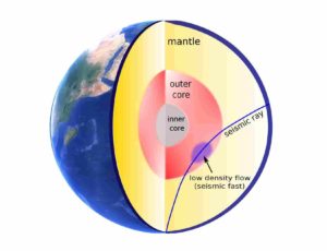
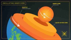
Our understanding of the inner core has expanded dramatically in the past 30 years. The inner core — a hot, dense ball of solid iron the size of Pluto — has been shown to move and/or change over decades. It’s also impossible to observe directly, meaning researchers struggle through indirect measurements to explain the pattern, speed and cause of the movement and changes.

Research published in 1996 was the first to propose the inner core rotates faster than the rest of the planet — also known as super-rotation — at roughly 1 degree per year. Subsequent findings from Vidale reinforced the idea that the inner core super-rotates, albeit at a slower rate.

Utilizing data from the Large Aperture Seismic Array (LASA), a U.S. Air Force facility in Montana, researcher Wei Wang and Vidale found the inner core rotated slower than previously predicted, approximately 0.1 degrees per year. The study analyzed waves generated from Soviet underground nuclear bomb tests from 1971-74 in the Arctic archipelago Novaya Zemlya using a novel beamforming technique developed by Vidale.

The new findings emerged when Wang and Vidale applied the same methodology to a pair of earlier atomic tests beneath Amchitka Island at the tip of the Alaskan archipelago — Milrow in 1969 and Cannikin in 1971. Measuring the compressional waves resulting from the nuclear explosions, they discovered the inner core had reversed direction, sub-rotating at least a tenth of a degree per year.

This latest study marked the first time the well-known six-year oscillation had been indicated through direct seismological observation.

“The idea the inner core oscillates was a model that was out there, but the community has been split on whether it was viable,” Vidale says. “We went into this expecting to see the same rotation direction and rate in the earlier pair of atomic tests, but instead we saw the opposite. We were quite surprised to find that it was moving in the other direction.”

Future research to dig deeper into why inner core formed

Vidale and Wang both noted future research would depend on finding sufficiently precise observations to compare against these results. By using seismological data from atomic tests in previous studies, they have been able to pinpoint the exact location and time of the very simple seismic event, says Wang. However, the Montana LASA closed in 1978 and the era of U.S. underground atomic testing is over, meaning that the researchers would need to rely on comparatively imprecise earthquake data, even with recent advances in instrumentation.

The study does support the speculation that the inner core oscillates based on variations in the length of day — plus or minus 0.2 seconds over six years — and geomagnetic fields, both of which match the theory in both amplitude and phase. Vidale says the findings provide a compelling theory for many questions posed by the research community.

“The inner core is not fixed — it’s moving under our feet, and it seems to going back and forth a couple of kilometers every six years,” Vidale said. “One of the questions we tried to answer is, does the inner core progressively move or is it mostly locked compared to everything else in the long term? We’re trying to understand how the inner core formed and how it moves over time — this is an important step in better understanding this process.”

Reference:
Wei Wang, John E. Vidale. Seismological observation of Earth’s oscillating inner core. Science Advances, 2022; 8 (23) DOI: 10.1126/sciadv.abm9916

Note: The above post is reprinted from materials provided by University of Southern California. Original written by Paul McQuiston.

Yellowstone’s history of hydrothermal explosions over the past 14,000 years

Yellowstone National Park

While much of public attention on Yellowstone focuses on its potential to produce large supereruptions, the hazards that are much more likely to occur are smaller, violent hydrothermal explosions. Hydrothermal explosions occur when near-boiling water suddenly flashes into steam, releasing large amounts of energy. The energy release fractures the rock downward, often leaving behind a crater. The same sources that can produce these explosions are what give Yellowstone its well-known hot springs, geysers, and fumaroles.

The Yellowstone Lake area in Yellowstone National Park hosts at least eight large craters produced by hydrothermal explosions, including three of the largest hydrothermal explosion craters known on Earth. Compared to other areas of interest within Yellowstone, hydrothermal explosion craters have not been as thoroughly studied. In a new study published on Tuesday in GSA Bulletin, researchers evaluated the history of hydrothermal explosions at Yellowstone Lake over the past 14,000.

“The hydrothermal system in Yellowstone is the largest in the world and is driven by high heat flow over a large area, by high precipitation rates, and by active seismicity and deformation. Over 10,000 hydrothermal features are present in Yellowstone,” said Lisa Morgan, lead author of the study. “For this study, we wanted to know more about the recent geologic history of Yellowstone Lake and what role hydrothermal activity has had in the lake, especially the role of hydrothermal explosions and their triggering mechanisms.”

The research team collected sediment cores from across the northern portion of Yellowstone Lake and correlated them with cores that were previously collected in the vicinity, with the goal of characterizing their chemical and physical attributes and identifying hydrothermal explosion deposits in the cores.

“Hydrothermal explosion sediments deposited underwater had never been described in published literature. In analyzing the cores, we made a lot of discoveries and had several surprises. Number one was how different the explosion deposits found in the cores looked from explosion deposits on land. That was to be expected since one was deposited through a water column and one was deposited on land,” said Morgan.

The researchers found evidence for at least 16 deposits in the cores that were produced by hydrothermal explosions. While 14 of the deposits represented more localized explosion events, two of the deposits were associated with two of Yellowstone’s largest hydrothermal explosion craters: the Mary Bay and Elliott’s craters.

The Mary Bay hydrothermal explosion occurred 13,000 years ago and resulted in a 2.5-km (1.5-mi) wide crater, which is partly submerged under the lake. While deposits from the Mary Bay explosion exposed on land had been previously studied, the sediment cores from the lake demonstrated that the extent of its deposits was larger than previously thought and that the lake level must have been lower at the time of the explosion.

The researchers concluded that the Mary Bay explosion was triggered by a sudden 14-m (46-ft) drop in lake level caused by a seismic event and a tsunami that eroded the outlet waterway of Yellowstone Lake.

The Elliott’s Crater explosion occurred 8,000 years ago and produced a 700-m (2,300-ft) wide crater. The crater is fully submerged underwater, and no deposits from the explosion are exposed on land. Based on records in the cores, the deposits from Elliott’s Crater were also more broadly distributed than previously thought.

Differing from how the Mary Bay Crater likely formed, the researchers determined that Elliott’s Crater formed when a seismic event fractured the dome cap of the hydrothermal system. In Yellowstone Lake, hydrothermal domes form when underlying pockets of gas or gas-charged fluids cause overlying sediments to arch upwards. Rupturing this dome would result in a sudden loss of pressure, triggering a hydrothermal explosion.

Many of the smaller deposits in the sediment cores were from previously unknown younger hydrothermal explosions. As has been consistent with previous studies of the explosion craters, there appears to be no relation between them and volcanic eruptions at Yellowstone.

“Given what we see from Yellowstone Lake and elsewhere in Yellowstone, hydrothermal explosions of various scales will continue to occur,” said Morgan.

Reference:
L.A. Morgan, W.C.P. Shanks, K.L. Pierce, N. Iverson, C.M. Schiller, S.R. Brown, P. Zahajska, R. Cartier, R.W. Cash, J.L. Best, C. Whitlock, S. Fritz, W. Benzel, H. Lowers, D.A. Lovalvo, J.M. Licciardi. The dynamic floor of Yellowstone Lake, Wyoming, USA: The last 14 k.y. of hydrothermal explosions, venting, doming, and faulting. GSA Bulletin, 2022; DOI: 10.1130/B36190.1

Note: The above post is reprinted from materials provided by Geological Society of America.

Bizarre meat-eating dinosaur joins ‘Rogues’ Gallery’ of giant predators from classic fossil site in Egypt’s Sahara Desert

Andrew McAfee, Carnegie Museum of Natural History

An Egyptian-American team of researchers has announced the discovery of a new kind of large-bodied meat-eating dinosaur, or theropod, from a celebrated fossil site in Egypt’s Sahara Desert. The fossil of a still-unnamed species provides the first known record of the abelisaurid group of theropods from a middle Cretaceous-aged (approximately 98 million years old) rock unit known as the Bahariya Formation, which is exposed in the Bahariya Oasis of the Western Desert of Egypt.

In the early 20th century, this locality famously yielded the original specimens of a host of remarkable dinosaurs — including the colossal sail-backed fish-eater Spinosaurus — which were then destroyed in World War II. Abelisaurid fossils had previously been found in Europe and in many of today’s Southern Hemisphere continents, but never before from the Bahariya Formation. The team describes the Bahariya abelisaurid discovery in a paper published today in Royal Society Open Science.

The study was led by Ohio University graduate student Belal Salem, based on work he initiated while a member of the Mansoura University Vertebrate Paleontology Center (MUVP) in Mansoura, Egypt. The research team also included Ohio University Heritage College of Osteopathic Medicine professor of biomedical sciences Patrick O’Connor; Matt Lamanna, associate curator of vertebrate paleontology at Carnegie Museum of Natural History; Sanaa El-Sayed, a doctoral student at the University of Michigan and the MUVP’s former vice director; Hesham Sallam, a professor at the American University in Cairo (AUC) and Mansoura University and the founding director of the MUVP; and additional colleagues from Benha University and the Egyptian Environmental Affairs Agency.

The fossil in question, a well-preserved vertebra from the base of the neck, was recovered by a 2016 MUVP expedition to the Bahariya Oasis. The vertebra belongs to an abelisaurid, a kind of bulldog-faced, small-toothed, tiny-armed theropod that is estimated to have been roughly six meters (20 feet) in body length. Abelisaurids — most notably represented by the horned, demonic-looking Patagonian form Carnotaurus of Jurassic World and Prehistoric Planet fame — were among the most diverse and geographically widespread large predatory dinosaurs in the southern landmasses during the Cretaceous Period, the final time period of the Age of Dinosaurs. Along with Spinosaurus and two other giant theropods (Carcharodontosaurus and Bahariasaurus), the new abelisaurid fossil adds yet another species to the cadre of large predatory dinosaurs that roamed what is now the Egyptian Sahara roughly 98 million years ago.

“During the mid-Cretaceous, the Bahariya Oasis would’ve been one of the most terrifying places on the planet,” says Salem, a new student in the biological sciences graduate program at Ohio University. “How all these huge predators managed to coexist remains a mystery, though it’s probably related to their having eaten different things, their having adapted to hunt different prey.”

The new vertebra holds implications for the biodiversity of Cretaceous dinosaurs in Egypt and the entire northern region of Africa. It is the oldest known fossil of Abelisauridae from northeastern Africa, and shows that, during the mid-Cretaceous, these carnivorous dinosaurs ranged across much of the northern part of the continent, east to west from present day Egypt to Morocco, to as far south as Niger and potentially beyond. Spinosaurus and Carcharodontosaurus are also known from Niger and Morocco, and a close relative of Bahariasaurus has been found in the latter nation as well, suggesting that this fauna of large to gigantic theropods coexisted throughout much of northern Africa at this time.

How can the discovery of a single neck vertebra lead researchers to conclude that the fossil belongs to a member of Abelisauridae, a kind of carnivorous dinosaur that has never been found in the Bahariya Formation before? The answer is remarkably simple: it is virtually identical to the same bone in other, better-known abelisaurids such as Carnotaurus from Argentina and Majungasaurus from Madagascar. As coauthor and Salem’s graduate advisor Patrick O’Connor, who in 2007 published an exhaustive study of the vertebral anatomy of Majungasaurus,explains, “I’ve examined abelisaur skeletons from Patagonia to Madagascar. My first glimpse of this specimen from photos left no doubt about its identity. Abelisaurid neck bones are so distinctive.”

The Site

The Bahariya Oasis is renowned within paleontological circles for having yielded the type specimens (the original, first-discovered, name-bearing fossils) of several extraordinary dinosaurs during the early 20th century, including, most famously, Spinosaurus. Unfortunately, all Bahariya dinosaur fossils collected prior to World War II were destroyed during an Allied bombing of Munich in 1944.

As a graduate student in the early 2000s, study coauthor Matt Lamanna helped make the first dinosaur discoveries from the oasis since the infamous 1944 air raid, including the gargantuan sauropod (long-necked plant-eating dinosaur) Paralititan. “The Bahariya Oasis has taken on near-legendary status among paleontologists for having produced the first-known fossils of some of the world’s most amazing dinosaurs,” says Lamanna, “but for more than three quarters of a century, those fossils have existed only as pictures in old books.” Thankfully, discoveries made during recent expeditions led by researchers from AUC and MUVP — such as the new abelisaurid vertebra — are helping to restore the paleontological legacy of this classic site. These expeditions have recovered a wealth of additional fossils that the researchers plan to unveil in the near future.

As team member Sanaa El-Sayed, who co-led the 2016 expedition that collected the abelisaurid vertebra, explains, “This bone is just the first of many important new dinosaur fossils from the Bahariya Oasis.”

The Bahariya Formation holds promise to shed further light on mid-Cretaceous African dinosaurs and the vanished ecosystems in which they once lived. Unlike more thoroughly explored rocks of the same age in Morocco that tend to yield isolated bones, the Bahariya Formation appears to preserve partial skeletons of dinosaurs and other land-living animals with a relatively high degree of frequency. The more bones that are preserved within the skeleton of a given fossil backboned species, the more paleontologists can generally learn about it. The propensity of the Bahariya Oasis for producing associated partial skeletons suggests that much remains to be learned from this historic locality.

“In terms of Egyptian dinosaurs, we’ve really just scratched the surface,” notes study coauthor Hesham Sallam. “Who knows what else might be out there?” Recent efforts by Professor Sallam and his collaborators from around the planet are putting students from Egypt in lead roles in the research process. Both the field expedition that recovered the new abelisaurid fossil and the follow-up laboratory work were led by MUVP-based student researchers and contributing authors on the paper. “Working with MUVP and its faculty and students, like Belal Salem, continues to inspire me, as I see the next generation of paleontologists taking a prominent role in sharing their views on the history of our planet,” adds O’Connor.

Research on the new abelisaurid vertebra was supported by a field research grant to Matt Lamanna from the National Geographic Society’s Committee for Research and Exploration, grants to Hesham Sallam from Mansoura University and the American University in Cairo intramural grant program, and a grant to Patrick O’Connor from the National Science Foundation (EAR-1525915).

Reference:
Belal S. Salem, Matthew C. Lamanna, Patrick M. O’Connor, Gamal M. El-Qot, Fatma Shaker, Wael A. Thabet, Sanaa El-Sayed, Hesham M. Sallam. First definitive record of Abelisauridae (Theropoda: Ceratosauria) from the Cretaceous Bahariya Formation, Bahariya Oasis, Western Desert of Egypt. Royal Society Open Science, 2022; 9 (6) DOI: 10.1098/rsos.220106

Note: The above post is reprinted from materials provided by Ohio University.

Hot-blooded T. rex and cold-blooded Stegosaurus: Chemical clues reveal dinosaur metabolisms

Hot-blooded T. rex and cold-blooded Stegosaurus

For decades, paleontologists have debated whether dinosaurs were warm-blooded, like modern mammals and birds, or cold-blooded, like modern reptiles. Knowing whether dinosaurs were warm- or cold-blooded could give us hints about how active they were and what their everyday lives were like, but the methods to determine their warm- or cold-bloodedness — how quickly their metabolisms could turn oxygen into energy — were inconclusive. But in a new paper in Nature, scientists are unveiling a new method for studying dinosaurs’ metabolic rates, using clues in their bones that indicated how much the individual animals breathed in their last hour of life.

“This is really exciting for us as paleontologists — the question of whether dinosaurs were warm- or cold-blooded is one of the oldest questions in paleontology, and now we think we have a consensus, that most dinosaurs were warm-blooded,” says Jasmina Wiemann, the paper’s lead author and a postdoctoral researcher at the California Institute of Technology.

“The new proxy developed by Jasmina Wiemann allows us to directly infer metabolism in extinct organisms, something that we were only dreaming about just a few years ago. We also found different metabolic rates characterizing different groups, which was previously suggested based on other methods, but never directly tested,” says Matteo Fabbri, a postdoctoral researcher at the Field Museum in Chicago and one of the study’s authors.

People sometimes talk about metabolism in terms of how easy it is for someone to stay in shape, but at its core, “metabolism is how effectively we convert the oxygen that we breathe into chemical energy that fuels our body,” says Wiemann, who is affiliated with Yale University and the Natural History Museum of Los Angeles County.

Animals with a high metabolic rate are endothermic, or warm-blooded; warm-blooded animals like birds and mammals take in lots of oxygen and have to burn a lot of calories in order to maintain their body temperature and stay active. Cold-blooded, or ectothermic, animals like reptiles breathe less and eat less. Their lifestyle is less energetically expensive than a hot-blooded animal’s, but it comes at a price: cold-blooded animals are reliant on the outside world to keep their bodies at the right temperature to function (like a lizard basking in the sun), and they tend to be less active than warm-blooded creatures.

With birds being warm-blooded and reptiles being cold-blooded, dinosaurs were caught in the middle of a debate. Birds are the only dinosaurs that survived the mass extinction at the end of the Cretaceous, but dinosaurs (and by extension, birds) are technically reptiles — outside of birds, their closest living relatives are crocodiles and alligators. So would that make dinosaurs warm-blooded, or cold-blooded?

Scientists have tried to glean dinosaurs’ metabolic rates from chemical and osteohistological analyses of their bones. “In the past, people have looked at dinosaur bones with isotope geochemistry that basically works like a paleo-thermometer,” says Wiemann — researchers examine the minerals in a fossil and determine what temperatures those minerals would form in. “It’s a really cool approach and it was really revolutionary when it came out, and it continues to provide very exciting insights into the physiology of extinct animals. But we’ve realized that we don’t really understand yet how fossilization processes change the isotope signals that we pick up, so it is hard to unambiguously compare the data from fossils to modern animals.”

Another method for studying metabolism is growth rate. “If you look at a cross section of dinosaur bone tissue, you can see a series of lines, like tree rings, that correspond to years of growth,” says Fabbri. “You can count the lines of growth and the space between them to see how fast the dinosaur grew. The limit relies on how you transform growth rate estimates into metabolism: growing faster or slower can have more to do with the animal’s stage in life than with its metabolism, like how we grow faster when we’re young and slower when we’re older.”

The new method proposed by Wiemann, Fabbri, and their colleagues doesn’t look at the minerals present in bone or how quickly the dinosaur grew. Instead, they look at one of the most basic hallmarks of metabolism: oxygen use. When animals breathe, side products form that react with proteins, sugars, and lipids, leaving behind molecular “waste.” This waste is extremely stable and water-insoluble, so it’s preserved during the fossilization process. It leaves behind a record of how much oxygen a dinosaur was breathing in, and thus, its metabolic rate.

The researchers looked for these bits of molecular waste in dark-colored fossil femurs, because those dark colors indicate that lots of organic matter are preserved. They examined the fossils using Raman and Fourier-transform infrared spectroscopy — “these methods work like laser microscopes, we can basically quantify the abundance of these molecular markers that tell us about the metabolic rate,” says Wiemann. “It is a particularly attractive method to paleontologists, because it is non-destructive.”

The team analyzed the femurs of 55 different groups of animals, including dinosaurs, their flying cousins the pterosaurs, their more distant marine relatives the plesiosaurs, and modern birds, mammals, and lizards. They compared the amount of breathing-related molecular byproducts with the known metabolic rates of the living animals and used those data to infer the metabolic rates of the extinct ones.

The team found that dinosaurs’ metabolic rates were generally high. There are two big groups of dinosaurs, the saurischians and the ornithischians — lizard hips and bird hips. The bird-hipped dinosaurs, like Triceratops and Stegosaurus, had low metabolic rates comparable to those of cold-blooded modern animals. The lizard-hipped dinosaurs, including theropods and the sauropods — the two-legged, more bird-like predatory dinosaurs like Velociraptor and T. rex and the giant, long-necked herbivores like Brachiosaurus — were warm- or even hot-blooded. The researchers were surprised to find that some of these dinosaurs weren’t just warm-blooded — they had metabolic rates comparable to modern birds, much higher than mammals. These results complement previous independent observations that hinted at such trends but could not provide direct evidence, because of the lack of a direct proxy to infer metabolism.

These findings, the researchers say, can give us fundamentally new insights into what dinosaurs’ lives were like.

“Dinosaurs with lower metabolic rates would have been, to some extent, dependent on external temperatures,” says Wiemann. “Lizards and turtles sit in the sun and bask, and we may have to consider similar ‘behavioral’ thermoregulation in ornithischians with exceptionally low metabolic rates. Cold-blooded dinosaurs also might have had to migrate to warmer climates during the cold season, and climate may have been a selective factor for where some of these dinosaurs could live.”

On the other hand, she says, the hot-blooded dinosaurs would have been more active and would have needed to eat a lot. “The hot-blooded giant sauropods were herbivores, and it would take a lot of plant matter to feed this metabolic system. They had very efficient digestive systems, and since they were so big, it probably was more of a problem for them to cool down than to heat up.” Meanwhile, the theropod dinosaurs — the group that contains birds — developed high metabolisms even before some of their members evolved flight.

“Reconstructing the biology and physiology of extinct animals is one of the hardest things to do in paleontology. This new study adds a fundamental piece of the puzzle in understanding the evolution of physiology in deep time and complements previous proxies used to investigate these questions. We can now infer body temperature through isotopes, growth strategies through osteohistology, and metabolic rates through chemical proxies,” says Fabbri.

In addition to giving us insights into what dinosaurs were like, this study also helps us better understand the world around us today. Dinosaurs, with the exception of birds, died out in a mass extinction 65 million years ago when an asteroid struck the Earth. “Having a high metabolic rate has generally been suggested as one of the key advantages when it comes to surviving mass extinctions and successfully radiating afterwards,” says Wiemann — some scientists have proposed that birds survived while the non-avian dinosaurs died because of the birds’ increased metabolic capacity. But this study, Wiemann says, helps to show that this isn’t true: many dinosaurs with bird-like, exceptional metabolic capacities went extinct.

“We are living in the sixth mass extinction,” says Wiemann, “so it is important for us to understand how modern and extinct animals physiologically responded to previous climate change and environmental perturbations, so that the past can inform biodiversity conservation in the present and inform our future actions.”

Reference:
Jasmina Wiemann, Iris Menéndez, Jason M. Crawford, Matteo Fabbri, Jacques A. Gauthier, Pincelli M. Hull, Mark A. Norell, Derek E. G. Briggs. Fossil biomolecules reveal an avian metabolism in the ancestral dinosaur. Nature, 2022; DOI: 10.1038/s41586-022-04770-6

Note: The above post is reprinted from materials provided by Field Museum.

Seismic waves from earthquakes reveal changes in the Earth’s outer core

The blue path illustrates a core-penetrating seismic wave moving through a region in the outer core, where the seismic speed has increased because a low-density flow has moved into the region. Credit: Ying Zhou

In May 1997, a large earthquake shook the Kermadec Islands region in the South Pacific Ocean. A little over 20 years later, in September 2018, a second big earthquake hit the same location, its waves of seismic energy emanating from the same region.

Though the earthquakes occurred two decades apart, because they occurred in the same region, they’d be expected to send seismic waves through the Earth’s layers at the same speed, said Ying Zhou, a geoscientist with the Department of Geosciences in the Virginia Tech College of Science.

But in data recorded at four of more than 150 Global Seismographic Network stations that log seismic vibrations in real time, Zhou found an anomaly among the twin events: During the 2018 earthquake, a set of seismic waves known as SKS waves traveled about one second faster than their counterparts had in 1997.

According to Zhou, whose findings were recently published in Communications Earth & Environment, that one-second discrepancy in SKS wave travel time gives us an important and unprecedented glimpse of what’s happening deeper in the Earth’s interior, in its outer core.

What’s inside counts

The outer core is sandwiched between the mantle, the thick layer of rock underneath the Earth’s crust, and the inner core, the planet’s deepest interior layer. It’s composed mainly of liquid iron that undergoes convection, or fluid flow, as the Earth cools. This resulting swirling of liquid metal produces electrical currents responsible for generating the Earth’s magnetic field, which protects the planet and all life on it from harmful radiation and solar winds.

Without its magnetic field, the Earth could not sustain life, and without the moving flows of liquid metal in the outer core, the magnetic field wouldn’t work. But scientific understanding of this dynamic is based on simulations, said Zhou, an associate professor. “We only know that in theory, if you have convection in the outer core, you’ll be able to generate the magnetic field,” she said.

Scientists also have only been able to speculate about the source of gradual changes in strength and direction of the magnetic field that have been observed, which likely involves changing flows in the outer core.

“If you look at the north geomagnetic pole, it’s currently moving at a speed of about 50 kilometers [31 miles] per year,” Zhou said. “It’s moving away from Canada and toward Siberia. The magnetic field is not the same every day. It’s changing. Since it’s changing, we also speculate that convection in the outer core is changing with time, but there’s no direct evidence. We’ve never seen it.”

Zhou set out to find that evidence. The changes happening in the outer core aren’t dramatic, she said, but they’re worth confirming and fundamentally understanding. In seismic waves and their changes in speed on a decade time scale, Zhou saw a means for “direct sampling” of the outer core. That’s because the SKS waves she studied pass right through it.

“SKS” represents three phases of the wave: First it goes through the mantle as an S wave, or shear wave; then into the outer core as a compressional wave; then back out through the mantle as an S wave. How fast these waves travel depend in part on the density of the outer core that’s in their path. If the density is lower in a region of the outer core as the wave penetrates it, the wave will travel faster, just as the anomalous SKS waves did in 2018.

“Something has changed along the path of that wave, so it can go faster now,” Zhou said.

To Zhou, the difference in wave speed points to low-density regions forming in the outer core in the 20 years since the 1997 earthquake. That higher SKS wave speed during the 2018 earthquake can be attributed to the release of light elements such as hydrogen, carbon, and oxygen in the outer core during convection that takes place as the Earth cools, she said.

“The material that was there 20 years ago is no longer there,” Zhou said. “This is new material, and it’s lighter. These light elements will move upward and change the density in the region where they’re located.”

To Zhou, it’s evidence that movement really is happening in the core, and it’s changing over time, as scientists have theorized. “We’re able to see it now,” she said. “If we’re able to see it from seismic waves, in the future, we could set up seismic stations and monitor that flow.”

What’s next

That’s Zhou’s next effort. Using a method of wave measurement known as interferometry, her team plans to analyze continuous seismic recordings from two seismic stations, one of which will serve as a “virtual” earthquake source, she said.

“We can use earthquakes, but the limitation of relying on earthquake data is that we can’t really control the locations of the earthquakes,” Zhou said. “But we can control the locations of seismic stations. We can put the stations anywhere we want them to be, with the wave path from one station to the other station going through the outer core. If we monitor that over time, then we can see how core-penetrating seismic waves between those two stations change. With that, we will be better able to see the movement of fluid in the outer core with time.”

Note: The above post is reprinted from materials provided by Virginia Tech.

How plesiosaurs swam underwater

Representative Image: Plesiosaur attack, artwork.

Plesiosaurs, which lived about 210 million years ago, adapted to life underwater in a unique way: their front and hind legs evolved in the course of evolution to form four uniform, wing-like flippers. In her thesis supervised at Ruhr-Universität Bochum and the University of Bonn, Dr. Anna Krahl investigated how they used these to move through the water. Partly by using the finite element method, which is widely used in engineering, she was able to show that it was necessary to twist the flippers in order to travel forward. She was able to reconstruct the movement sequence using bones, models and reconstructions of the muscles.

Plesiosaurs belong to a group of saurians called Sauropterygia, or paddle lizards, that re-adapted to living in the oceans. They evolved in the late Triassic 210 million years ago, lived at the same time as the dinosaurs, and became extinct at the end of the Cretaceous period. Plesiosaurs are characterized by an often extremely elongated neck with a small head — the elasmosaurs even have the longest neck of all vertebrates. But there were also large predatory forms with a rather short neck and huge skulls. In all plesiosaurs, the neck is attached to a teardrop-shaped, hydrodynamically well adapted body with a markedly shortened tail.

Researchers have puzzled for 120 years how plesiosaurs swam

The second feature that makes plesiosaurs so unusual are their four uniform wing-like flippers. “Having the front legs transformed into wing-like flippers is relatively common in evolution, for instance in sea turtles. Never again, however, did the hind legs evolve into an almost identical-looking airfoil-like wing,” explains Anna Krahl, whose doctoral thesis was supervised by Professor P. Martin Sander (Bonn) and Professor Ulrich Witzel (Bochum). Sea turtles and penguins, for example, have webbed feet. For more than 120 years, researchers in vertebrate paleontology have puzzled over how plesiosaurs might have swum with these four wings. Did they row like freshwater turtles or ducks? Did they fly underwater like sea turtles and penguins? Or did they combine underwater flight and rowing like modern-day sea lions or the pig-nosed turtle? It is also unclear whether the front and rear flippers were flapped in unison, in opposition, or out of phase.

Anna Krahl has been studying the body structure of plesiosaurs for several years. She examined the bones of the shoulder and pelvic girdle, the front and hind flippers, and the shoulder joint surfaces of the plesiosaur Cryptoclidus eurymerus from the Middle Jurassic period (about 160 million years ago) on a complete skeleton displayed in the Goldfuß Museum of the University of Bonn. Plesiosaurs have stiffened elbow, knee, hand, and ankle joints, but functioning shoulder, hip, and finger joints. “Analysis comparing them to modern-day sea turtles, and based on what is known about their swimming process, indicated that plesiosaurs were probably not able to rotate their flippers as much as would be necessary for rowing,” concludes Krahl, summarizing one of her preliminary papers. Rowing is primarily a back-and-forth motion that uses water resistance to move forward. The preferred direction of flipper movement in plesiosaurs, on the other hand, was up-and-down, as used by underwater fliers to generate propulsion.

The question remained how plesiosaurs could ultimately twist their flippers to place them in a hydrodynamically favorable position and produce lift without rotating the upper arm and thigh around the longitudinal axis. “This could work by means of twisting the flippers around their long axis,” says Anna Krahl. “Other vertebrates, such as the leatherback turtle, have also been shown to use this movement to generate propulsion through lift.” Twisting, for example, involves bending the first finger far downward and the last finger far upward. The remaining fingers bridge these extreme positions so that the flipper tip is almost vertical without requiring any real rotation in the shoulder or wrist.

A reconstruction of the muscles of the fore- and hind flippers for Cryptoclidus using reptiles alive today showed that plesiosaurs could actively enable such flipper twisting. In addition to classical models, the researchers also made computer tomographies of the humerus and femur of Cryptoclidus and used them to create virtual 3D models. “These digital models were the basis for calculating the forces using a method we borrowed from engineering: the finite element method, or FE,” explains Anna Krahl. All the muscles and their angles of attachment on the humerus and femur were virtually reproduced in an FE computer program that can simulate physiological functional loads, for example on construction components but also on prostheses. Based on muscle force assumptions from a similar study on sea turtles, the team was able to calculate and visualize the loading on each bone.

Twisting of the flippers can be proven indirectly

During a movement cycle, the limb bones are loaded by compression, tension, bending and torsion. “The FE analyses showed that the humerus and femur in the flippers are functionally loaded mainly by compression and to a much lesser extent by tensile stress,” Anna Krahl explains. “This means that the plesiosaur built its bones by using as little material as necessary.” This natural state can only be maintained if the muscles that twist the flippers and the muscles that wrap around the bone are included. “We can therefore indirectly prove that plesiosaurs twisted their flippers in order to swim efficiently,” Anna Krahl sums up.

The team was also able to calculate forces for the individual muscles that generated the upstroke and downstroke. For instance, it transpired that the downstroke of both pairs of flippers was more powerful than the upstroke. This is comparable to our sea turtles today and different from today’s penguins, which move forward the same distance with the upstroke as with the downstroke. “Plesiosaurs adapted to life in water in a very different way than whales, for example,” notes Anna Krahl, who now works at the Eberhard Karls University in Tübingen, Germany. “This unique path of evolution exemplifies the importance of paleontological research because it’s the only way we can appreciate the full range of what evolution can bring about.”

Reference:
Anna Krahl, Andreas Lipphaus, P. Martin Sander, Ulrich Witzel. Determination of muscle strength and function in plesiosaur limbs: finite element structural analyses of Cryptoclidus eurymerus humerus and femur. PeerJ, 2022; 10: e13342 DOI: 10.7717/peerj.13342

Note: The above post is reprinted from materials provided by Ruhr-University Bochum. Original written by Meike Drießen.

First Australians ate giant eggs of huge flightless birds, ancient proteins confirm

  Genyornis eggshell recently exposed by wind erosion of sand dune in which it was buried, South Australia. Credit: Gifford Miller
Genyornis eggshell recently exposed by wind erosion of sand dune in which it was buried, South Australia. Credit: Gifford Miller

Proteins extracted from fragments of prehistoric eggshell found in the Australian sands confirm that the continent’s earliest humans consumed the eggs of a two-metre tall bird that disappeared into extinction over 47,000 years ago.

Burn marks discovered on scraps of ancient shell several years ago suggested the first Australians cooked and ate large eggs from a long-extinct bird – leading to fierce debate over the species that laid them.

Now, an international team led by scientists from the universities of Cambridge and Turin have placed the animal on the evolutionary tree by comparing the protein sequences from powdered egg fossils to those encoded in the genomes of living avian species.

“Time, temperature and the chemistry of a fossil all dictate how much information we can glean,” said senior co-author Prof Matthew Collins from the University of Cambridge’s Department of Archaeology.

“Eggshells are made of mineral crystals that can tightly trap some proteins, preserving this biological data in the harshest of environments – potentially for millions of years.”

According to findings published in the journal Proceedings of the National Academy of Sciences, the ancient eggs came from Genyornis: a huge flightless “mihirung” – or ‘Thunder Bird’ – with tiny wings and massive legs that roamed prehistoric Australia, possibly in flocks.

Fossil records show that Genyornis stood over two metres tall, weighed between 220-240 kilograms, and laid melon-sized eggs of around 1.5 kg. It was among the Australian “mega-fauna” to vanish a few thousand years after humans arrived, suggesting people played a role in its extinction.

The earliest “robust” date for the arrival of humans to Australia is some 65,000 years ago. Burnt eggshells from the previously unconfirmed species all date to around 50 to 55 thousand years ago – not long before Genyornis is thought to have gone extinct – by which time humans had spread across most of the continent.

“There is no evidence of Genyornis butchery in the archaeological record. However, eggshell fragments with unique burn patterns consistent with human activity have been found at different places across the continent,” said senior co-author Prof Gifford Miller from the University of Colorado.

“This implies that the first humans did not necessarily hunt these enormous birds, but did routinely raid nests and steal their giant eggs for food,” he said. “Overexploitation of the eggs by humans may well have contributed to Genyornis extinction.”

While Genyornis was always a contender for the mystery egg-layer, some scientists argued that – due to shell shape and thickness – a more likely candidate was the Progura or ‘giant malleefowl’: another extinct bird, much smaller, weighing around 5-7 kg and akin to a large turkey.

The initial ambition was to put the debate to bed by pulling ancient DNA from pieces of shell, but genetic material had not sufficiently survived the hot Australian climate.

Miller turned to researchers at Cambridge and Turin to explore a relatively new technique for extracting a different type of “biomolecule”: protein.

While not as rich in hereditary data, the scientists were able to compare the sequences in ancient proteins to those of living species using a vast new database of biological material: the Bird 10,000 Genomes (B10K) project.

“The Progura was related to today’s megapodes, a group of birds in the galliform lineage, which also contains ground-feeders such as chickens and turkeys,” said study first author Prof Beatrice Demarchi from the University of Turin.

“We found that the bird responsible for the mystery eggs emerged prior to the galliform lineage, enabling us to rule out the Progura hypothesis. This supports the implication that the eggs eaten by early Australians were laid by Genyornis.”

The 50,000-year-old eggshell tested for the study came from the archaeological site of Wood Point in South Australia, but Prof Miller has previously shown that similar burnt shells can be found at hundreds of sites on the far western Ningaloo coast.

The researchers point out that the Genyornis egg exploitation behaviour of the first Australians likely mirrors that of early humans with ostrich eggs, the shells of which have been unearthed at archaeological sites across Africa dating back at least 100,000 years.

Prof Collins added: “While ostriches and humans have co-existed throughout prehistory, the levels of exploitation of Genyornis eggs by early Australians may have ultimately proved more than the reproductive strategies of these extraordinary birds could bear.”

Reference:
Beatrice Demarchi, Josefin Stiller, Alicia Grealy, Meaghan Mackie, Yuan Deng, Tom Gilbert, Julia Clarke, Lucas J. Legendre, Rosa Boano, Thomas Sicheritz-Pontén, John Magee, Guojie Zhang, Michael Bunce, Matthew James Collins, Gifford Miller. Ancient proteins resolve controversy over the identity of Genyornis eggshell. Proceedings of the National Academy of Sciences, 2022; DOI: 10.1073/pnas.2109326119

Note: The above post is reprinted from materials provided by University of Cambridge. Original written by Fred Lewsey.

Great white sharks may have contributed to megalodon extinction

 Tooth size comparison between extinct Early Pliocene Otodus megalodon tooth and a modern great white shark. © MPI for Evolutionary Anthropology

Tooth size comparison between extinct Early Pliocene Otodus megalodon tooth and a modern great white shark.
© MPI for Evolutionary Anthropology

The diet of fossil extinct animals can hold clues to their lifestyle, behaviour, evolution and ultimately extinction. However, studying an animal’s diet after millions of years is difficult due to the poor preservation of chemical dietary indicators in organic material on these timescales. An international team of scientists led by the Max Planck Institute for Evolutionary Anthropology in Leipzig, Germany, applied a new method to investigate the diet of the largest shark to have ever existed, the iconic Otodus megalodon. This new method investigates the zinc isotope composition of the highly mineralised part of teeth and proves to be particularly helpful to decipher the diet of these extinct animals.

Megatooth sharks like, Otodus megalodon, more commonly known as megalodon, lived between 23 and 3.6 million years ago in oceans around the globe and possibly reached as large as 20 metres in length. For comparison, the largest great white sharks today reach a total length of only six metres. Many factors have been discussed to explain the gigantism and extinction of megalodon, with its diet and dietary competition often being thought of as key factors.

In this study, researchers analysed zinc stable isotope ratios in modern and fossil shark teeth from around the globe, including teeth of megalodon and modern and fossil great white sharks. This new method allows scientists to investigate an animal’s trophic level, which indicates how far up the food chain an animal feeds. Zinc stable isotope analysis of tooth enameloid, the highly mineralised part of teeth, is comparable to much more established nitrogen isotope analysis of tooth collagen, the organic tissue in tooth dentine, which is used to assess the degree of animal matter consumption. However, “on the timescales we investigate, collagen is not preserved, and traditional nitrogen isotope analysis is therefore not possible,” explains lead author Jeremy McCormack, a researcher at the Max Planck Institute for Evolutionary Anthropology and the Goethe-University Frankfurt. “Here, we demonstrate, for the first time, that diet-related zinc isotope signatures are preserved in the highly mineralised enameloid crown of fossil shark teeth,” adds Thomas Tütken, professor at the Johannes Gutenberg University’s Institute of Geosciences.

Comparison of zinc isotope signals in fossil and modern sharks

Using this new method, the team compared the tooth zinc isotope signature of multiple extinct Early Miocene (20.4 to 16.0 million years ago) and Early Pliocene (5.3 to 3.6 million years ago) species with those of modern sharks. “We noticed a coherence of zinc isotope signals in fossil and modern analogue taxa, which boosts our confidence in the method and suggests that there may be minimal differences in zinc isotope values at the base of marine food webs, a confounding factor for nitrogen isotope studies,” explains Sora Kim, a professor from the University of California Merced.

Subsequently, the researchers analysed the zinc isotope ratios in megalodon teeth from the Early Pliocene and those in earlier megatooth sharks, Otodus chubutensis, from the Early Miocene as well as contemporaneous and modern great white sharks to investigate the impact these iconic species had on past ecosystems and each other. “Our results show, that both megalodon and its ancestor were indeed apex predators, feeding high up their respective food chains,” says Michael Griffiths, professor at the William Paterson University. “But what was truly remarkable is that zinc isotope values from Early Pliocene shark teeth from North Carolina, suggest largely overlapping trophic levels of early great white sharks with the much larger megalodon.”

Dietary competition of megalodon with great white sharks

“These results likely imply at least some overlap in prey hunted by both shark species,” notes Kenshu Shimada, professor at DePaul University, Chicago. “While additional research is needed, our results appear to support the possibility for dietary competition of megalodon with Early Pliocene great white sharks.”

New isotope methods such as zinc provide a unique window into the past. “Our research illustrates the feasibility of using zinc isotopes to investigate the diet and trophic ecology of extinct animals over millions of years, a method that can also be applied to other groups of fossil animals including our own ancestors,” concludes McCormack.

Reference:
Jeremy McCormack, Michael L. Griffiths, Sora L. Kim, Kenshu Shimada, Molly Karnes, Harry Maisch, Sarah Pederzani, Nicolas Bourgon, Klervia Jaouen, Martin A. Becker, Niels Jöns, Guy Sisma-Ventura, Nicolas Straube, Jürgen Pollerspöck, Jean-Jacques Hublin, Robert A. Eagle, Thomas Tütken. Trophic position of Otodus megalodon and great white sharks through time revealed by zinc isotopes. Nature Communications, 2022; 13 (1) DOI: 10.1038/s41467-022-30528-9

Note: The above post is reprinted from materials provided by Max Planck Institute for Evolutionary Anthropology.

Earth’s core: Unexpected flow behavior in liquid metals

Earth
Credit: Naeblys

Some metals are in liquid form, the prime example being mercury. But there are also enormous quantities of liquid metal in the Earth’s core, where temperatures are so high that part of the iron is molten and undergoes complex flows. A team at the Helmholtz-Zentrum Dresden-Rossendorf (HZDR) has now simulated a similar process in the laboratory and made a surprising discovery: Under certain circumstances, the flow of liquid metal is far more turbulent than expected — and this has a significant impact on heat transport, presents the group in the journal Physical Review Letters.

Temperatures deep inside the Earth are so high that part of its iron core is liquid. This liquid iron is in constant motion, continuously churning and circulating. It acts like a dynamo, causing our planet’s magnetic field to be generated. One driving force for this complex flow behavior of iron is the Earth’s rotation, another is what is referred to as “convection,” driven by temperature differences: Similar to the way warm air rises above a radiator, where it displaces cooler air, relatively hot iron in the Earth’s core flows to cooler areas, resulting in heat transfer. As yet, however, little is known about how these processes take place in detail. To better understand them, experts have to rely on theoretical calculations and computer simulations, as well as experiments that simulate what is happening — at least to some extent — on a laboratory scale.

One such experiment was conducted recently at the HZDR’s Institute of Fluid Dynamics. “We took two cylindrical vessels — a relatively small one about the size of a bucket and the other one shaped like a barrel with a volume of 60 liters,” explained project leader Dr. Tobias Vogt. “We filled these vessels with a metallic alloy of indium, gallium and tin, which is liquid at room temperature.” The experts heated the bottom of the vessels whilst cooling the top, creating a temperature difference of up to 50 degrees Celsius between the higher and lower layers.

Ultrasound provides in-depth view

This substantial temperature difference caused the liquid metal inside the vessels to churn: Driven by convection, locally warmer flow areas such as columns rose and mixed with the cooler parts — similar to a lava lamp. Since the metal alloy used by the team is opaque, however, they had to resort to a special analytical technique: “It is an ultrasound method used in medicine,” explained Dr. Sven Eckert, Head of Department Magnetohydrodynamics at the HZDR. “We fitted around 20 ultrasonic sensors to the vessels, enabling us to detect how liquid metal flows inside them.”

When analyzing the data, the research group made a surprising discovery. During the experiments, the experts had expected to find the clustering of individual flow areas to form a greater, more extensive structure, known as large-scale circulation. “This is comparable to a thermal wind, which is able to transport heat very effectively between the top and the bottom,” reported Vogt. “We were indeed able to observe this thermal wind in the smaller vessel — but with the larger vessel, the barrel, large temperature differences led to an almost complete breakdown of the wind.” This meant that heat was not transported as effectively as would have been expected. “We believe the cause of this to be the formation of much smaller-scale turbulence rather than a few large swirls, which makes heat transport less effective,” stated Vogt.

Implications for battery technology

These new findings could have implications for what happens in the Earth’s core: “To understand what is happening, experts are attempting to extrapolate the results of laboratory experiments to the scale of the Earth,” explained Sven Eckert. “But we have now shown that heat is transported less effectively under certain conditions than previous experiments had suggested.” This means that predictions for the Earth will likely also produce different values. “However, the real-life processes in the Earth’s core are many times more complex than in our laboratory experiments,” Tobias Vogt added. “For example, the flow of liquid iron is also influenced by the Earth’s magnetic field and rotation — ultimately, we know very little about these flow processes.”

In fact, the new findings could also prove relevant for technology, especially in areas involving liquid metals. For example, liquid metals are used in some types of batteries as well as for future solar power plants, and cool fusion reactors. To be able to take an even closer look at heat transport in liquid metals, the HZDR team are currently working on an advanced analytical technique. “Special induction sensors are expected to record flows in even greater detail than before and produce true 3D images,” remarked Sven Eckert. “Our initial measurements are very promising.”

Reference:
Felix Schindler, Sven Eckert, Till Zürner, Jörg Schumacher, Tobias Vogt. Collapse of Coherent Large Scale Flow in Strongly Turbulent Liquid Metal Convection. Physical Review Letters, 2022; 128 (16) DOI: 10.1103/PhysRevLett.128.164501

Note: The above post is reprinted from materials provided by Helmholtz-Zentrum Dresden-Rossendorf.

Scientists have discovered a new type of fossilization

Middle: Microscopic plankton cell-wall coverings preserved as “ghost” fossil impressions, pressed into the surface of ancient organic matter (183 million years old). Th
Middle: Microscopic plankton cell-wall coverings preserved as “ghost” fossil impressions, pressed into the surface of ancient organic matter (183 million years old). The images show the impressions of a collapsed cell-wall covering (a coccosphere) on the surface of a fragment of ancient organic matter (left) with the individual plates (coccoliths) enlarged to show the exquisite preservation of sub-micron-scale structures (right). The blue image is inverted to give a virtual fossil cast, i.e., to show the original three-dimensional form. The original plates have been removed from the sediment by dissolution, leaving behind only the ghost imprints. S.M. Slater, P. Bown et al / Science journal

An international team of scientists from UCL (University College London), the Swedish Museum of Natural History, Natural History Museum (London) and the University of Florence have found a remarkable type of fossilisation that has remained almost entirely overlooked until now.

The fossils are microscopic imprints, or “ghosts,” of single-celled plankton, called coccolithophores, that lived in the seas millions of years ago, and their discovery is changing our understanding of how plankton in the oceans are affected by climate change.

Coccolithophores are important in today’s oceans, providing much of the oxygen we breathe, supporting marine food webs, and locking carbon away in seafloor sediments. They are a type of microscopic plankton that surround their cells with hard calcareous plates, called coccoliths, and these are what normally fossilize in rocks.

Declines in the abundance of these fossils have been documented from multiple past global warming events, suggesting that these plankton were severely affected by climate change and ocean acidification. However, a study published today in the journal Science presents new global records of abundant ghost fossils from three Jurassic and Cretaceous warming events (94, 120 and 183 million years ago), suggesting that coccolithophores were more resilient to past climate change than was previously thought.

“The discovery of these beautiful ghost fossils was completely unexpected,” says Dr. Sam Slater from the Swedish Museum of Natural History. “We initially found them preserved on the surfaces of fossilized pollen, and it quickly became apparent that they were abundant during intervals where normal coccolithophore fossils were rare or absent — this was a total surprise!”

Despite their microscopic size, coccolithophores can be hugely abundant in the present ocean, being visible from space as cloud-like blooms. After death, their calcareous exoskeletons sink to the seafloor, accumulating in vast numbers, forming rocks such as chalk.

“The preservation of these ghost nannofossils is truly remarkable,” says Professor Paul Bown (UCL). “The ghost fossils are extremely small — their length is approximately five thousandths of a millimetre, 15 times narrower than the width of a human hair — but the detail of the original plates is still perfectly visible, pressed into the surfaces of ancient organic matter, even though the plates themselves have dissolved away.”

The ghost fossils formed while the sediments at the seafloor were being buried and turned into rock. As more mud was gradually deposited on top, the resulting pressure squashed the coccolith plates and other organic remains together, and the hard coccoliths were pressed into the surfaces of pollen, spores and other soft organic matter. Later, acidic waters within spaces in the rock dissolved away the coccoliths, leaving behind just their impressions — the ghosts.

“Normally, palaeontologists only search for the fossil coccoliths themselves, and if they don’t find any then they often assume that these ancient plankton communities collapsed,” explains Professor Vivi Vajda (Swedish Museum of Natural History). “These ghost fossils show us that sometimes the fossil record plays tricks on us and there are other ways that these calcareous nannoplankton may be preserved, which need to be taken into account when trying to understand responses to past climate change.”

Professor Silvia Danise (University of Florence) says: “Ghost nannofossils are likely common in the fossil record, but they have been overlooked due to their tiny size and cryptic mode of preservation. We think that this peculiar type of fossilization will be useful in the future, particularly when studying geological intervals where the original coccoliths are missing from the fossil record.”

The study focused on the Toarcian Oceanic Anoxic Event (T-OAE), an interval of rapid global warming in the Early Jurassic (183 million years ago), caused by an increase in CO2-levels in the atmosphere from massive volcanism in the Southern Hemisphere. The researchers found ghost nannofossils associated with the T-OAE from the UK, Germany, Japan and New Zealand, but also from two similar global warming events in the Cretaceous: Oceanic Anoxic Event 1a (120 million years ago) from Sweden, and Oceanic Anoxic Event 2 (94 million years ago) from Italy.

“The ghost fossils show that nannoplankton were abundant, diverse and thriving during past warming events in the Jurassic and Cretaceous, where previous records have assumed that plankton collapsed due to ocean acidification,” explains Professor Richard Twitchett (Natural History Museum, London). “These fossils are rewriting our understanding of how the calcareous nannoplankton respond to warming events.”

Finally, Dr. Sam Slater explains: “Our study shows that algal plankton were abundant during these past warming events and contributed to the expansion of marine dead zones, where seafloor oxygen-levels were too low for most species to survive. These conditions, with plankton blooms and dead zones, may become more widespread across our globally warming oceans.”

Reference:
Sam M. Slater, Paul Bown, Richard J. Twitchett, Silvia Danise, Vivi Vajda. Global record of “ghost” nannofossils reveals plankton resilience to high CO 2 and warming. Science, 2022; 376 (6595): 853 DOI: 10.1126/science.abm7330

Note: The above post is reprinted from materials provided by University College London.

Puzzling features deep in Earth’s interior illuminated

Molten lava from a Hawaiian volcano. Image: Willyam/Adobe

Molten lava from a Hawaiian volcano. Image: Willyam/Adobe

New research led by the University of Cambridge is the first to take a detailed image of an unusual pocket of rock at the boundary layer with Earth’s core, some three thousand kilometres beneath the surface.

The enigmatic area of rock, which is located almost directly beneath the Hawaiian Islands, is one of several ultra-low velocity zones — so-called because earthquake waves slow to a crawl as they pass through them.

The research, published today in Nature Communications, is the first to reveal the complex internal variability of one of these pockets in detail, shedding light on the landscape of Earth’s deep interior and the processes operating within it.

“Of all Earth’s deep interior features, these are the most fascinating and complex. We’ve now got the first solid evidence to show their internal structure — it’s a real milestone in deep earth seismology,” said lead author Zhi Li, PhD student at Cambridge’s Department of Earth Sciences.

Earth’s interior is layered like an onion: at the centre sits the iron-nickel core, surrounded by a thick layer known as the mantle, and on top of that a thin outer shell — the crust we live on. Although the mantle is solid rock, it is hot enough to flow extremely slowly. These internal convection currents feed heat to the surface, driving the movement of tectonic plates and fuelling volcanic eruptions.

Scientists use seismic waves from earthquakes to see beneath Earth’s surface — the echoes and shadows of these waves revealing radar-like images of deep interior topography. But until recently, images of the structures at the core-mantle boundary, an area of key interest for studying our planet’s internal heat flow, have been grainy and difficult to interpret.

The researchers used the latest numerical modelling methods to reveal kilometre-scale structures at the core-mantle boundary. According to co-author Dr Kuangdai Leng, who developed the methods while at the University of Oxford, “We are really pushing the limits of modern high-performance computing for elastodynamic simulations, taking advantage of wave symmetries unnoticed or unused before.” Leng, who is currently based at the Science and Technology Facilities Council, said that this means they can improve the resolution of the images by an order of magnitude compared to previous work.

They observed a 40% reduction in the speed of seismic waves travelling at the base of the ultra-low velocity zone beneath Hawaii. According to the authors, this supports existing proposals that the zone contains much more iron than the surrounding rocks — meaning it is denser and more sluggish. “It’s possible that this iron-rich material is a remnant of ancient rocks from Earth’s early history or even that iron might be leaking from the core by an unknown means,” said project lead, Dr Sanne Cottaar from Cambridge Earth Sciences.

The new research could also help scientists understand what sits beneath and gives rise to volcanic chains like the Hawaiian Islands. Scientists have started to notice a correlation between the location of the descriptively-named hotspot volcanoes, which include Hawaii and Iceland, and the ultra-low velocity zones at the base of the mantle. The origin of hotspot volcanoes has been widely debated, but the most popular theory suggests that plume-like structures bring hot mantle material all the way from the core-mantle boundary to the surface.

With images of the ultra-low velocity zone beneath Hawaii now in hand, the team can also gather rare physical evidence from what is likely the root of the plume feeding Hawaii. Their observation of dense, iron-rich rock beneath Hawaii would support surface observations, “Basalts erupting from Hawaii have anomalous isotope signatures which could either point to either an early-Earth origin or core leaking, it means some of this dense material piled up at the base must be dragged to the surface,” said Cottaar.

More of the core-mantle boundary now needs to be imaged to understand if all surface hotspots have a pocket of dense material at the base. Where and how the core-mantle boundary can be targeted does depend on where earthquakes occur, and where seismometers are installed to record the waves.

The team’s observations add to a growing body of evidence that Earth’s deep interior is just as variable as it’s surface. “These low velocity zones are one of the most intricate features we see at extreme depths — if we expand our search we are likely to see ever-increasing levels of complexity, both structural and chemical, at the core-mantle boundary,” said Li.

They now plan to apply their techniques to enhance the resolution of imaging of other pockets at the core-mantle boundary, as well as mapping new zones. Eventually they hope to map the geological landscape across the core-mantle boundary and understand its relationship with the dynamics and evolutionary history of our planet.

Reference:
Zhi Li, Kuangdai Leng, Jennifer Jenkins, Sanne Cottaar. Kilometer-scale structure on the core–mantle boundary near Hawaii. Nature Communications, 2022; 13 (1) DOI: 10.1038/s41467-022-30502-5

Note: The above post is reprinted from materials provided by University of Cambridge. The original text of this story is licensed under a Creative Commons License.

Which forces control the elevation of mountains?

 Puna Plateau (© Mitchall d'Arcy)
Puna Plateau (© Mitchall d’Arcy)

Scientists have come up with a new classification scheme for mountain belts that uses just a single number to describe whether the elevation of the mountain belt is controlled mainly by weathering and erosion or by properties of the Earth’s crust, i.e., the lithospheric strength: the “Beaumont number” (Bm). It’s named after Chris Beaumont, a scientist who, together with his team, developed coupled models of surface processes and tectonic forces. The scientists report about their findings in the current issue of Nature.

A Beaumont number between 0.4 and 0.5 means that the mountains are in a so-called flux steady state in which the controlling factors of mountain growth are tectonic forces and the lithospheric strength, balanced by weathering processes as, for example, in Taiwan. With a Bm value lower than 0.4, mountains are also in a flux steady state but with erosion as controlling factor like the Southern Alps of New Zealand. A Beaumont number above 0.5 means that the mountains still grow (non-steady state) with lithospheric strength controlling the process. Examples for this type are the Himalaya-Tibet mountains and the Central Andes.

This classification is resolving a long-standing question whether tectonic forces and strength of the Earth’s crust are the controlling factors of mountain elevation or weathering processes. The new study says it can be one or the other — depending on geographic location, climate and underground properties.

The team of scientists led by Sebastian G. Wolf of Bergen University in Norway used a new coupled surface process and mantle-scale tectonic model for their study by combining the thermomechanical tectonic model FANTOM with the landscape evolution model FastScape. Thus, they were able to reconcile high erosion rates in some active orogens with long-term survival of mountain belts for hundreds of millions of years.

Jean Braun of the GFZ German Research Centre for Geosciences, who co-authored the paper, says: “With our Beaumont number we can determine to which proportion tectonics, climate, and crustal strength control the height of mountain belts. And, for most mountain belts, this can be done without complex measurements or assumptions; all that is needed is a knowledge of the rate of convergence obtained from present-day plate velocities or plate reconstructions, the height of the mountain obtained from a topographic map and the widening rate obtained from the geological record. In a nutshell: Whether a mountain is short or tall is the product of slow or fast convergence, wet or dry climate, or strong or weak crust.” The Beaumont number shows which of these three factors is dominating.

Reference:
Sebastian G. Wolf, Ritske S. Huismans, Jean Braun, Xiaoping Yuan. Topography of mountain belts controlled by rheology and surface processes. Nature, 2022; DOI: 10.1038/s41586-022-04700-6

Note: The above post is reprinted from materials provided by GFZ GeoForschungsZentrum Potsdam, Helmholtz Centre.

Arc volcanoes are wetter than previously thought, with scientific and economic implications

volcanoes
volcanoes

The percentage of water in arc volcanoes, which form above subduction zones, may be far more than many previous studies have calculated.

This increased amount of water has broad implications for understanding how Earth’s lower crust forms, how magma erupts through the crust, and how economically important mineral ore deposits form, according to a new paper led by authors from the Woods Hole Oceanographic Institution (WHOI), “High water content of arc magmas recorded in cumulates from subduction zone lower crust,” published in Nature Geoscience.

The estimated water concentrations in primitive arc magmas from this study are more variable and significantly higher than the average of about four weight percent of water found in other studies, according to the paper. The results show that primitive arc H2O after extensive crystal fractionation in the lower arc crust, the paper adds.

“The big picture here is that water is essentially the lubricant of plate tectonics. The water content is going to affect all sorts of different parameters involved in how tectonic plates move,” says lead author Benjamin Urann, who was a doctoral student in the Massachusetts Institute of Technology (MIT) — WHOI Joint Program in Oceanography/Applied Ocean Science and Engineering at the time of the study.

“Being able to get some idea of what the actual water content of the arc magmas is, which is what we did in this study, can help refine estimates of how much water is being subducted deep into the mantle globally; quantify different water reservoirs on Earth, including surface and deep water reservoirs; and better understand the transport between these different reservoirs,” says Urann, who is currently a National Science Foundation Ocean Sciences Postdoctoral Research Fellow at the University of Wyoming. Urann added that the paper also discusses the implications of water content for forming economically important ore deposits, such as porphyry copper deposits. These deposits make up about 60% of the world’s source of copper, according to the U.S. Geological Survey.

Many earlier studies have relied on techniques such as measuring melt inclusions — which are tiny droplets of magma that have been trapped by a crystals that grows around them — and measuring lava and other volcanic deposits that have erupted to the Earth’s surface. “However, these methods have inherent limitations that obfuscate the full range of H20 in arc magmas,” the paper states.

Urann and his Ph.D. supervisor, Véronique Le Roux, who is a co-author of the paper, developed methods with the Secondary Ion Mass Spectrometry instrument located at WHOI to measure water content in minerals, with their work building on other efforts that suggested that arc magmas should contain significantly more H20 than inferred from melt-inclusion measurements.

The researchers determined that instead of examining lava samples that have erupted to the Earth’s surface, it would be fruitful to examine deep crustal magmas that have not lost too much of their water content.

“Although you can’t retrieve the liquid magma at these depths, what you may be able to sample is a cumulate: it is magma that has solidified at depth in the crust. We’re lucky enough that sometimes with plate tectonics, some of those really deep crusts are exhumed at the surface,” says Le Roux, associate scientist in the Geology and Geophysics department at WHOI, and Faculty member of the MIT-WHOI Joint Program. The researchers used cumulates that the paper’s co-authors had collected from the Kohistan paleo-arc terrane in the Himalaya Mountain range in northwestern Pakistan.

Instead of examining surface rocks that travel far up through the crust as magma, and lose much of their water content in the process, the researchers examined magma — lower crustal cumulates — that had crystallized deep down in the crust at a high enough pressure to retain their original water content signature.

Le Roux says that “analyzing water in cumulate minerals is a new promising approach to access the deep levels of the crust in subduction zones.”

The researchers calculated that the magma they analyzed contained between 10-20 weight percent of water depending on the magma’s composition. “While this weight percent of water had been predicted experimentally as being possible, it had never been shown on natural samples,” Le Roux said.

“The bottom line is that arc magmas can be wetter than we thought,” said Urann.

This study was supported by NSF awards to Le Roux, Behn, and Chin, funding from the Woods Hole Oceanographic Institution Ocean Venture Fund and from the National Science Foundation’s (NSF, USA) Division of Ocean Sciences Post-doctoral Research Fellow grant to Urann;; and support from the Visiting Scholar at SCIENCE programme at the University of Copenhagen, Denmark, to Le Roux.

Reference:
B. M. Urann, V. Le Roux, O. Jagoutz, O. Müntener, M. D. Behn, E. J. Chin. High water content of arc magmas recorded in cumulates from subduction zone lower crust. Nature Geoscience, 2022; DOI: 10.1038/s41561-022-00947-w

Note: The above post is reprinted from materials provided by Woods Hole Oceanographic Institution.

Research shows how Gulf of Mexico escaped ancient mass extinction

Examples of radiolarians, a type of microplankton. These tiny lifeforms need normal salinity seawater with plenty of nutrients including silica to grow and maintain their glassy shells. Researchers at the University of Texas Institute for Geophysics found fossilized radiolarians in geologic samples dating back 56 million years, proving that life persisted in the Gulf of Mexico despite global warming that left many oceans barren. Credit: U.S. Geological Survey

An ancient bout of global warming 56 million years ago that acidified oceans and wiped-out marine life had a milder effect in the Gulf of Mexico, where life was sheltered by the basin’s unique geology — according to research by the University of Texas Institute for Geophysics (UTIG).

Published in the journal Marine and Petroleum Geology, the findings not only shed light on an ancient mass extinction, but could also help scientists determine how current climate change will affect marine life and aid in efforts to find deposits of oil and gas.

And although the Gulf of Mexico is very different today, UTIG geochemist Bob Cunningham, who led the research, said that valuable lessons can be drawn about climate change today from how the Gulf was impacted in the past.

“This event known as the Paleocene-Eocene Thermal Maximum or PETM is very important to understand because it’s pointing towards a very powerful, albeit brief, injection of carbon into the atmosphere that’s akin to what’s happening now,” he said.

Cunningham and his collaborators investigated the ancient period of global warming and its impact on marine life and chemistry by studying a group of mud, sand, and limestone deposits found across the Gulf.

They sifted through rock chips brought up during oil and gas drilling and found an abundance of microfossils from radiolarians — a type of plankton — that had surprisingly thrived in the Gulf during the ancient global warming. They concluded that a steady supply of river sediments and circulating ocean waters had helped radiolarians and other microorganisms survive even while Earth’s warming climate became more hostile to life.

“In a lot of places, the ocean was absolutely uninhabitable for anything,” said UTIG biostratigrapher Marcie Purkey Phillips. “But we just don’t seem to see as severe an effect in the Gulf of Mexico as has been seen elsewhere.”

The reasons for that go back to geologic forces reshaping North America at the time. About 20 million years before the ancient global warming, the rise of the Rocky Mountains had redirected rivers into the northwest Gulf of Mexico — a tectonic shift known as the Laramide uplift — sending much of the continent’s rivers through what is now Texas and Louisiana into the Gulf’s deeper waters.

When global warming hit and North America became hotter and wetter, the rain-filled rivers fire-hosed nutrients and sediments into the basin, providing plenty of nutrients for phytoplankton and other food sources for the radiolarians.

The findings also confirm that the Gulf of Mexico remained connected to the Atlantic Ocean and the salinity of its waters never reached extremes — a question that until now had remained open. According to Phillips, the presence of radiolarians alone — which only thrive in nutrient-rich water that’s no saltier than seawater today — confirmed that the Gulf’s waters did not become too salty. Cunningham added that the organic content of sediments decreased farther from the coast, a sign that deep currents driven by the Atlantic Ocean were sweeping the basin floor.

The research accurately dates closely related geologic layers in the Wilcox Group (a set of rock layers that house an important petroleum system), a feat that can aid in efforts to find undiscovered oil and gas reserves in formations that are the same age. At the same time, the findings are important for researchers investigating the effects of today’s global warming because they show how the water and ecology of the Gulf changed during a very similar period of climate change long ago.

The study compiled geologic samples from 36 industry wells dotted across the Gulf of Mexico, plus a handful of scientific drilling expeditions including the 2016 UT Austin-led investigation of the Chicxulub asteroid impact, which led to the extinction of non-avian dinosaurs.

For John Snedden, a study coauthor and senior research scientist at UTIG, the study is a perfect example of industry data being used to address important scientific questions.

“The Gulf of Mexico is a tremendous natural archive of geologic history that’s also very closely surveyed,” he said. “We’ve used this very robust database to examine one of the highest thermal events in the geologic record, and I think it’s given us a very nuanced view of a very important time in Earth’s history.”

Snedden is also program director of UT’s Gulf Basin Depositional Synthesis, an industry-funded project to map the geologic history of the entire Gulf basin, including the current research. UTIG is a research unit of UT Jackson School of Geosciences.

Reference:
Robert Cunningham, Marcie Purkey Phillips, John W. Snedden, Ian O. Norton, Christopher M. Lowery, Jon W. Virdell, Craig D. Barrie, Aaron Avery. Productivity and organic carbon trends through the Wilcox Group in the deep Gulf of Mexico: Evidence for ventilation during the Paleocene-Eocene Thermal Maximum. Marine and Petroleum Geology, 2022; 140: 105634 DOI: 10.1016/j.marpetgeo.2022.105634

Note: The above post is reprinted from materials provided by University of Texas at Austin.

Ancient ocean floors could help in the search for critical minerals

Examining ocean floors key to minerals needed for renewable energy. Image: Supplied

Studying ancient ocean floors could help discover minerals needed to produce electric cars and solar panels.

Researchers at The University of Queensland led a collaborative study that examined the remnants of ocean floors in eastern Australia and central Asia and applied a method to date the age of calcite trapped inside.

Dr Renjie Zhou from UQ’s School of Earth and Environmental Sciences said the findings could make it easier to source critical minerals used in renewable and clean technologies.

“Calcite and other hydrothermal minerals are often observed in critical mineral deposits and form under mineralising fluid activities,” Dr Zhou said.

“Our work shows that we can trace the history of fluids in the Earth’s crust and see when and what mineral resources they might generate.”

The renewable energy sector is continuing to grow rapidly with increasing demand for technologies like wind turbines, solar panels, electric vehicles and batteries.

“These often require large quantities of critical minerals,” he said.

“Electric vehicles need up to four times more copper than conventional cars and a single wind turbine uses several tonnes of permanent magnets made of rare earth metals.”

Dr Zhou said being able to study and discover these minerals was going to become increasingly important.

“Researchers across many institutions are doing excellent work in this field, including UQ’s Centre for Geoanalytical Mass Spectrometry,” Dr Zhou said.

“Our hope is to expand our collaboration with industry and academia to increase the understanding and discovery of critical minerals in the future.”

References:

  • Johannes Rembe, Renjie Zhou, Edward R. Sobel, Jonas Kley, Jie Chen, Jian-Xin Zhao, Yuexing Feng, Daryl L. Howard. Calcite U–Pb dating of altered ancient oceanic crust in the North Pamir, Central Asia. Geochronology, 2022; 4 (1): 227 DOI: 10.5194/gchron-4-227-2022
  • Goran Andjić, Renjie Zhou, David M. Buchs, Jonathan C. Aitchison, Jianxin Zhao. Paleozoic ocean plate stratigraphy unraveled by calcite U-Pb dating of basalt and biostratigraphy. Communications Earth & Environment, 2022; 3 (1) DOI: 10.1038/s43247-022-00446-1

Note: The above post is reprinted from materials provided by University of Queensland.

The link between temperature, dehydration and tectonic tremors in Alaska

Tectonic map of the Alaska subduction zone
The thick blue solid line outlines the Yakutat terrane. The white circle indicates the epicentre of the low-frequency tectonic tremors, and the light blue dashed line shows the area where the tectonic tremors occurred, which is used in Figures 2 to 4. The area inside the pink dashed box is the model region used in this study, and the pink dashed line down the center of the box divides the model region into northeast and southwest areas, and represents the boundary between the subducted Yakutat terrane and the subducted Pacific plate in the model. The black lines indicate the isodepth contours of the upper surface of the subducted oceanic plate (with a contour interval of 20 km), red arrows show the plate motion velocity in the Aleutian Trench, and the red triangles indicate volcanoes.

A Kobe University research group has shed light on how low-frequency tectonic tremors occur; these findings will contribute towards better predictions of future megathrust earthquakes.

In addition to the subducting Pacific plate, the Alaska subduction zone is also characterized by a subducting oceanic plateau called the Yakutat terrane. Low-frequency tectonic tremors, which are a type of slow earthquake, have only been detected in the subducted Yakutat terrane area. However, the mechanism by which these events occur is not well understood.

Researchers at Kobe University performed a 3D numerical thermomechanical simulation of thermal convection in the Alaska subduction zone with the aim of revealing the mechanism behind these low-frequency tremors. Based on the 3D thermal structure obtained from the simulation, and the indications of hydrous minerals contained in the slab, the researchers calculated the water content distribution and compared the results of these calculations in the area where the tremors occur.

The results revealed high levels of dehydration in the marine sediment layers and ocean crust in the earthquake region. The researchers believe that the reason the tremors only occur in the Yakutat terrane is because the marine sediment layers and ocean crust are thicker there, which means that the level of dehydration is higher than in the western adjacent Pacific plate (where tectonic tremors don’t occur).

The Kobe University research group consisted of 2nd year Master’s student IWAMOTO Kaya (Department of Planetology, Graduate School of Science), Academic Researcher SUENAGA Nobuaki and Professor YOSHIDA Shoichi (both of the Research Center for Urban Safety and Security).

These results were published in the British online scientific journal ‘Scientific Reports’ (Nature Publishing Group) on April 14, 2022.

Main Points

  • Elucidating the mechanism by which low-frequency tremors occur is important for understanding the plate subduction process. It is believed that this will also help illuminate how shallower megathrust earthquakes occur.
  • In this study, the research group constructed a 3D thermomechanical model of the Alaska subduction zone and calculated the subducting plate’s maximum water content and level of dehydration.
  • The dehydration levels from the subducting plate’s marine sediment layers and ocean crust were highest in the region where low-frequency tremors occur. Therefore, it is thought that the water expelled from the subducted plate contributes towards the occurrence of these tectonic tremors.

Research Background

An oceanic plateau called the Yakutat terrane is subducting in the Alaska subduction zone. Low-frequency tectonic tremors occur at this subducting plateau. The region where slow earthquakes (such as low-frequency tectonic tremors) occur is deeper and adjacent to the area where megathrust earthquakes occur, which suggests a connection between the two. Revealing the mechanism behind how low-frequency tectonic tremors occur is therefore important for understanding the occurrence of various earthquake events in subduction zones. This research group constructed a 3D thermomechanical model of the Alaska subduction zone so that they could investigate the temperature and level of dehydration in the areas near where low- frequency tremors occur.

Research Methodology

The researchers performed a 3D numerical thermomechanical simulation in accordance with the subduction of the Yakutat terrane and Pacific plate in the Alaska subduction zone. It is thought that as the Pacific plate subducts, it brings the hydrous minerals in the slab into the deep high temperature and high pressure regions, and these conditions cause a dehydration reaction where water is expelled from the hydrous minerals. Based on the 3D thermal structure obtained from the numerical simulation, the researchers determined dehydration levels of the hydrous minerals in the slab. From these results, it was understood that in the region where low- frequency tremors occur, a large amount of water is expelled due to the high temperature and high pressure conditions that cause the dehydration degradation reactions. It is thought that low frequency earthquakes don’t occur in the Pacific plate because it has thin layers and therefore experiences little dehydration. On the other hand, the Yakutat terrane’s ocean crust and marine sediment layers are comparatively thicker, meaning that it experiences high levels of dehydration. The researchers concluded that this is why low-frequency tectonic tremors only occur in the Yakutat terrane.

Further Research

In 1964, a megathrust earthquake occurred in Alaska. This is the biggest earthquake that has occurred in the Alaska subduction zone and the second most powerful earthquake recorded in world history. The low-frequency tectonic tremors that were the subject of this research occur close to the epicenter of the 1964 earthquake, at the downdip of the plate interface. Next, the research group will continue to make thermomechanical models of various subduction zones to search for universal and regional characteristics of the causal mechanisms behind undersea megathrust earthquakes and slow earthquakes. This research will contribute towards improving understanding of how earthquakes occur and our ability to predict future megathrust earthquakes.

Glossary

1. Low-frequency tectonic tremors: A seismic event that is characterized by lower-frequency seismic waves than a regular earthquake.
2. Slow earthquake: A phenomenon where a fault slips at a slower speed than in a regular earthquake.
3. Oceanic plateau: A comparatively flat area of the seabed.
4. Slab: refers to the subducted plate.
5. Hydrous mineral: Minerals that contain OH groups in their crystal structure.
6. Dehydration degradation reaction: As the plate subducts, the resulting temperature and pressure causes phase transformations of hydrous minerals and they expel water.

Reference:
Kaya Iwamoto, Nobuaki Suenaga, Shoichi Yoshioka. Relationship between tectonic tremors and 3-D distributions of thermal structure and dehydration in the Alaska subduction zone. Scientific Reports, 2022; 12 (1) DOI: 10.1038/s41598-022-10113-2

Note: The above post is reprinted from materials provided by Kobe University.

A new 225-million-year-old reptile from Brazil

Partial skull of Maehary bonapartei (CAPPA/UFSM 0300), left side, highlighting the maxilla. Photo: Rodrigo Temp Müller.

In a new study published in PeerJ — Reassessment of Faxinalipterus minimus, a purported Triassic pterosaur from southern Brazil resulted in the description of a new taxon — researchers present Maehary bonapartei a small reptile that is considered to be the most basal of the evolutionary lineage that gave rise to pterosaurs. The study also demonstrates that Faxinalipterus minimus is not a winged reptile, contrary to what was previously supposed.

Maehary bonapartei represents a small reptile that is considered to be the most basal of the evolutionary lineage that gave rise to pterosaurs. The study also demonstrates that Faxinalipterus minimus is not a winged reptile, contrary to what was previously supposed.

Researchers from the National Museum/UFRJ, the Federal University of Santa Maria, the Catalan Institute of Paleontology, the Regional University of Cariri, the Federal University of Pampa, the Federal University of Rio Grande do Sul and COPPE/UFRJ presented a review of a small reptile named Faxinalipterus minimus, from Triassic rocks (about 225 million years ago) in Rio Grande do Sul. Faxinalipterus was described more than a decade ago (2010), being assigned to the Pterosauria, a group which includes the first vertebrates to develop active flight. The original fossil of Faxinalipterus was composed by bones from the postcranial sleleton and a part of the skull (an upper jaw with several teeth), found separately in two field expeditions, carried out in 2002 and 2005, at the Linha São Luiz fossil site, located in the municipality of Faxinal do Soturno. Thus, it was not possible to say with certainty whether all parts belonged to the same type of animal and species. Despite this, it was assumed at the time that all the bones belonged to a single species, named Faxinalipterus minimus.

The new study of Faxinalipterus established that there were two distinct species, with the isolated jaw representing another animal. This was possible based on the comparison with a new fossil recently found at the same site (Linha São Luiz). The new material is composed of an incomplete skull, whose maxilla exhibits the same features of the maxilla attributed to Faxinalipterus. In addition, there are parts of the mandible, scapula and some vertebrae. The maxilla of Faxinalipterus can therefore be incorporated into the description of the new fossil, that was named Maehary bonapartei.

“There was always a great doubt whether the two specimens attributed to Faxinalipterus represented the same species, and whether this was a flying reptile,” commented Alexander Kellner, a specialist in pterosaurs who currently directs the Museu Nacional/UFRJ. Having examined the specimen shortly after publication in 2010, he saw that several bones could be misidentified and the lack of diagnostic features of pterosaurs, including the absence of specific features on the humerus (forelimb bone), such as a large and projected deltopectoral crest, which is typical of pterosaurs. Borja Holgado, also a specialist in pterosaurs from the Catalan Institute of Paleontology and currently a researcher at the Regional University of Cariri (Ceará), analyzed the material and agreed with the initial conclusions. “It was clear to me that this is a primitive reptile that did not belong to pterosaurs, as it did not present any unequivocal features of this lineage” explained Holgado and pointed out: “But the present knowledge of the faunas at the end of the Triassic indicates that the disparity of animals at that time was so great that animals that might resemble pterosaurs at first glance, but really they are not flying reptiles. This is what happened to Faxinalipterus and Maehary.”

“The material on which Faxinalipterus is based is very fragile and very incomplete. In addition, parts of the bones were covered by rock matrix, which required a more detailed preparation” commented Cesar Schultz, from UFRGS and one of the authors of the 2010 work and of the new research that has just been published.

The preparation of the original material required a lot of experience and was carried out at the National Museum. “Fortunately, we were able to photograph the entire specimen in detail,” said Orlando Grillo, who took care to reproduce in the form of drawings each anatomical detail of the bones of Faxinalipterus.

It was with the help of a CT scanner that the enigma was revealed. “Computed tomography has been an increasingly used tool in paleontological studies” highlights Ricardo Lopes from COPPE/UFRJ. “It is a non-destructive analysis that allows the visualization of anatomical details still covered by the sedimentary rock where the fossil is preserved” adds Olga Araújo, also from COPPE.

“In the original work from 2010, we found that the teeth present in the maxilla of Faxinalipterus were very closely spaced, which is a characteristic of early Triassic pterosaurs. However, tomography of the maxilla showed that the teeth were not as separated as initially thought, since many teeth had been lost during the fossilization process. As a result, the dentition pattern and the close-spacing between the alveoli (cavities where the teeth are inserted) were not consistent with pterosaurs,” highlights Marina Soares.

After these studies, there was still a doubt about who, after all, Faxinalipterus was. The solution came from the finding of a new specimen that had been collected in the same region where the specimens of Faxinalipterus came from. “Systematic collections have been carried out by CAPPA (Support Center for Paleontological Research of the Fourth Colony), from UFSM, revealing a series of new fossil species for the Triassic of Rio Grande do Sul” commented Flávio Pretto. At the Linha de São Luiz fossil site, in the municipality of Faxinal do Soturno, several fossils have already been found, such as close relatives of mammals, dinosaurs and other reptiles. The region where the excavations were carried out is located in the territory of the Quatro Colônia — that is seeking to become an UNESCO Geopark.

“When we had access to the study that was being developed by the National Museum team, it became clear that the maxilla, until then referred to Faxinalipterus, was very similar to the material we were studying,” added Leonardo Kerber. “They were definitely not examples of a pterosaur,” reinforced Felipe Pinheiro, from UNIPAMPA, a researcher who is also an expert in winged reptiles.

Using an anatomical database, the team established that Faxinalipterus would be closely related to lagerpetids, a branch considered to be a sister group to Pterosauria in more recent studies. Together, lagerpetids and pterosaurs form a broader group called Pterosauromorpha. In this context, the new species Maehary bonapartei was positioned as the most primitive member within Pterosauromorpha. “That is, Faxinalipterus and Maehary are not pterosaurs, but are related to them. Especially Maehary is configured as a key element in the elucidation of how the anatomical characteristics evolved along the lineage of pterosauromorphs to the pterosaurs themselves, fully adapted to the flight,” points out Rodrigo Müller. “These species, with an estimated length of 30 cm for Faxinalipterus and 40 cm for Maehary, demonstrate the importance of continuing to collect fossils in this region.”

The genus name of the new species comes from Ma’ehary, an expression of the original Guarani-Kaiowa people, which means “who looks at the sky” in allusion to its position in the evolutionary line of reptiles, being the most primitive of the Pterosauromorpha, group which includes the fascinating pterosaurs. The specific name is a fitting tribute to the main researcher of fossil vertebrates in Argentina, José Fernando Bonaparte (1928-2020), who died recently, and who worked actively together with Brazilian paleontologists in outcrops of Rio Grande do Sul, in the collection and description of many extinct vertebrates that lived during the Triassic period, including Faxinalipterus.

Now researchers are looking for new findings that help to understand how the first forms of this fascinating group of pterosaurs came to be.

Reference:
Alexander W.A. Kellner, Borja Holgado, Orlando Grillo, Flávio Augusto Pretto, Leonardo Kerber, Felipe Lima Pinheiro, Marina Bento Soares, Cesar Leandro Schultz, Ricardo Tadeu Lopes, Olga Araújo, Rodrigo Temp Müller. Reassessment of Faxinalipterus minimus, a purported Triassic pterosaur from southern Brazil with the description of a new taxon. PeerJ, 2022; 10: e13276 DOI: 10.7717/peerj.13276

Note: The above post is reprinted from materials provided by PeerJ.

Volcanoes at fault if the Earth slips

One of the strombolian explosions that have occurred at Stromboli about every 10 minutes for at least 2000 years. © UNIGE, Luca Caricchi

The 2016 Kumamoto earthquakes shocked inhabitants of the western island of Kyushu, causing hundreds of casualties and serious damage to vital infrastructure. The epicenter of the quake was traced to the Futagawa fault in a region neighboring Mount Aso, an active volcano in Kumamoto Prefecture that last erupted in October 2021.

An investigation of earth displaced by the series of quakes has offered potentially new clues into seismic activity in regions close to volcanoes. The study has also attributed the root cause of the 7.3-magnitude mainshock to specific geological damage.

The Futagawa strike-slip fault is a vertical break in the ground tracing a line southwest originating from Mount Aso, where the two sides of the fault point straight down and brush against each other side to side during an earthquake.

The research team had anticipated that any rupturing would occur exclusively near the strike-slip fault system. But as Weiren Lin of KyotoU’s Graduate School of Engineering says, ”Our discovery of a relatively large dip-slipdisplacement at the site was unexpected.”

As part of the team’s exploration around the epicenter of the 2016 quakes, scientists drilled a series of bore holes, including one that measured more than 600 meters deep. By extracting and analyzing the types of rocks present in these cores, they were able to reconstruct the different layers of earth around the fault.

Surprisingly, at two boreholes 80 meters apart, the scientists noticed that the same layer of rock sediment was appearing at different depths and separated by more than 200 meters vertically. This large gap could only be explained by the current strike-slip motion, where the two sides of the fault move up and down with respect to each other.

The team has attributed this dramatic change in the fault slip mode to eruption activity of Aso occurring around this time. Such observations from the Aso volcanic region could apply more broadly to similar volcanic areas near other subduction zones.

Lin concludes, ”Until about 87,000 years ago, this fault was moving in a completely different way. We hope that our results increase understanding of interactions between faulting and volcanic activities in other regions of the world.”

Reference:
Susumu Shibutani, Weiren Lin, Koichiro Sado, Akihiro Aizawa, Katsuaki Koike. An Ancient >200 m Cumulative Normal Faulting Displacement Along the Futagawa Fault Dextrally Ruptured During the 2016 Kumamoto, Japan, Earthquake Identified by a Multiborehole Drilling Program. Geochemistry, Geophysics, Geosystems, 2022; 23 (1) DOI: 10.1029/2021GC009966

Note: The above post is reprinted from materials provided by Kyoto University.

Researchers discover overlooked Jurassic Park of lizards

The fossil of Jurassic lizard Eichstaettisaurus. Credit: Jorge Herrera Flores

New research published today in eLife by researchers from the Institut Català de Paleontologia Miquel Crusafont (ICP) and the University of Bristol (UB) moves back the moment of the radiation of squamates — the group of reptiles that includes lizards, snakes and worm lizards — to the Jurassic, a long time before current estimates.

The Squamata is the largest order of reptiles, including lizards, snakes and worm lizards. Squamates are all cold-blooded, and their skins are covered by horny scales. They are key parts of modern terrestrial faunas, especially in warmer climates, with an astonishing diversity of more than 10,000 species. However, understanding the evolutionary paths that forged their success are still poorly understood.

There is consensus that all the main squamate groups had arisen before the event that wiped out dinosaurs and other groups of reptiles at the end of the Mesozoic era. Before that global catastrophic event, through the Cretaceous, many terrestrial tetrapod groups like mammals, lizards and birds, apparently underwent a great diversification during the so-called Cretaceous Terrestrial Revolution, triggered by the rise of flowering plants. The scarcity of fossil remains of squamates through the Jurassic suggested that the main burst of squamate evolution happened in the Cretaceous (between 145 and 66 Myr.), when their fossil record dramatically improves.

Now, a new paper published in eLife, led by Arnau Bolet, paleontologist at the Institut Català de Paleontologia Miquel Crusafont and the University of Bristol, however, challenges this view by suggesting a much earlier radiation of squamates. Along with colleagues from the University of Bristol Michael Benton, Tom Stubbs and Jorge Herrera-Flores, their research concludes that this group of reptiles probably achieved a diverse array of adaptations in the Jurassic (between 201 and 145 Myr.), long before previously thought. “Even though Jurassic squamates are rare, reconstructed evolutionary trees show that all the main specializations of squamates evolved then, and it’s possible to distinguish adaptations of geckoes, iguanas, skinks, worm lizards, and snakes some 50 million years earlier than had been thought,” explains Michael Benton, co-author of the research.

But how could the scarce Jurassic fossils suggest an early burst in evolution? The key is in their anatomy. The few Jurassic squamates do not show primitive morphologies as would be expected, but they relate directly to the diverse modern groups. “Instead of finding a suite of generalized lizards on the stem of the squamate tree, what we found in the Jurassic were the first representatives of many modern groups, showing advanced morphological features,” says Arnau Bolet, lead author of the article.

The observed times of divergence, morphospace plots and evolutionary rates, all suggest that the Jurassic was a time of innovation in squamate evolution, during which the bases of the success of the group were established. According to these results, the apparent sudden increase in diversity observed in the Cretaceous could be related to an improved fossil record, capable of recording a larger number of species, or to a burst of origins of new species related to the new kinds of forests and insects.

Establishing the timing and mode of radiation of squamates is key for not only understanding the dynamics of terrestrial ecosystems in the Mesozoic, but also for deciphering how the group achieved an astonishing diversity of more than 10,000 species, only rivalled by birds among tetrapods.

Reference:
Arnau Bolet, Thomas L Stubbs, Jorge A Herrera-Flores, Michael J Benton. The Jurassic rise of squamates as supported by lepidosaur disparity and evolutionary rates. eLife, 2022; 11 DOI: 10.7554/eLife.66511

Note: The above post is reprinted from materials provided by University of Bristol.

Dinosaur extinction changed plant evolution

The large, woody fruits of the Manicaria saccifera palm that depend on large animals for their dispersal. (Picture: John Dransfield, Royal Botanic Gardens, Kew)

With the extinction of large, non-flying dinosaurs 66 million years ago, large herbivores were missing on Earth for the subsequent 25 million years. Since plants and herbivorous animals influence each other, the question arises whether, and how this very long absence and the later return of the so-called “megaherbivores” affected the evolution of the plant world.

To answer this question, a research team led by iDiv and Leipzig University analysed fossil and living palms today. Genetic analyses enabled the researchers to trace the evolutionary developments of plants during and after the absence of megaherbivores. Thus, they first confirmed the common scientific assumption that many palm species at the time of the dinosaurs bore large fruits and were covered with spines and thorns on their trunks and leaves.

However, the research team found that the “evolutionary speed” with which new palm species with small fruits arose during the megaherbivore gap decreased, whereas the evolutionary speed of those with large fruits remained almost constant. The size of the fruits themselves, however, also increased. So, there were palms with large fruits even after the extinction of the dinosaurs. Apparently, much smaller animals could also eat large fruits and spread the seeds with their excretions. “We were thus able to refute the previous scientific assumption that the presence of large palm fruits depended exclusively on megaherbivores,” says the study’s first author Dr Renske Onstein from iDiv and Leipzig University. “We therefore assume that the lack of influence of large herbivores led to denser vegetations in which plants with larger seeds and fruits had an evolutionary advantage.”

However, the defence traits of the plants; spines and thorns on leaves and stems, showed a different picture: the number of palm species with defence traits decreased during the megaherbivore gap. “Defence traits without predators apparently no longer offered evolutionary advantages,” says Onstein, who heads the junior research group Evolution and Adaptation at iDiv. “However, they returned in most palm species when new megaherbivores evolved, in contrast to the changes in fruits, which persisted.”

With their work, the researchers shed new light on evolution and adaptation during one of the most enigmatic and unique periods in the history of plant evolution, during and after megaherbivore extinctions. Understanding how megaherbivore extinctions affected plant evolution in the past can also help predict future ecological developments. For example, the authors have noted the loss of traits during the megaherbivore gap. This loss can affect important ecosystem functions and processes, such as seed dispersal or herbivory. The ongoing extinction of large animals due to human hunting and climate change may thus also affect trait variation in plant communities and ecosystems today and in the foreseeable future.

Reference:
Renske E. Onstein, W. Daniel Kissling, H. Peter Linder. The megaherbivore gap after the non-avian dinosaur extinctions modified trait evolution and diversification of tropical palms. Proceedings of the Royal Society B: Biological Sciences, 2022; 289 (1972) DOI: 10.1098/rspb.2021.2633

Note: The above post is reprinted from materials provided by German Centre for Integrative Biodiversity Research (iDiv) Halle-Jena-Leipzig. Original written by Urs Moesenfechtel.

Related Articles