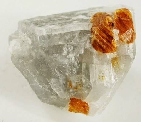
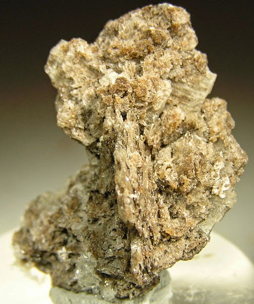
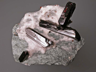
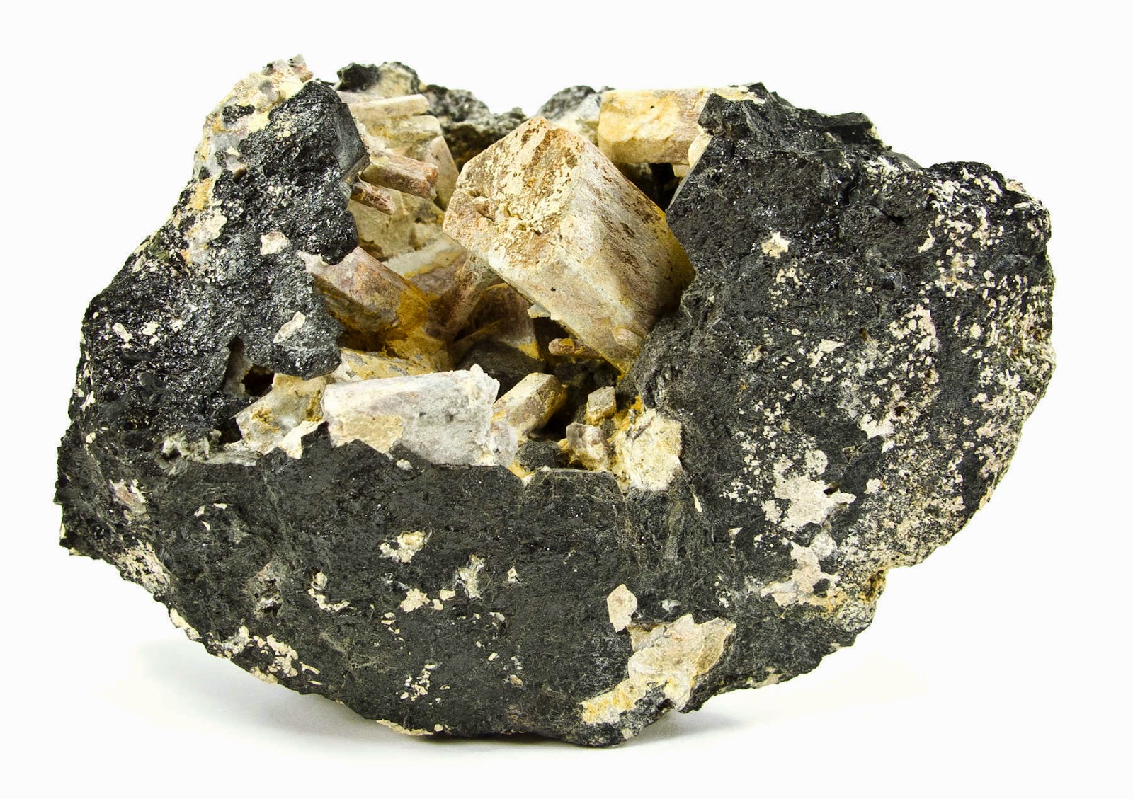
Chemical Formula: Na3Mg(CO3)2Cl Locality: Searles Lake, San Bernardino Co., California. Name Origin: Named after C. H. Northup (b.1861), grocer, of San Jose, California, who found the first specimen.
Northupite is an uncommon evaporite mineral, with the chemical formula Na3Mg(CO3)2Cl. It occurs as colourless to dark grey or brown octahedral crystals and as globular masses. In synthetic material it forms a series with tychite (Na6Mg2(CO3)4SO4).
It was discovered in 1895 at Searles Lake, San Bernardino County, California by C. H. Northup (born 1861) from San Jose, California, for whom Northupite is named.
It occurs associated with tychite, pirssonite at Searles Lake and with shortite, trona, pirssonite, gaylussite, labuntsovite, searlesite, norsethite, loughlinite, pyrite and quartz in the Green River Formation of Wyoming.
History
Discovery date : 1895 Town of Origin : SEARLES LAKE, BORAX LAKE, SAN BERNARDINO CO., CALIFORNIE Country of Origin: USA
Optical properties
Optical and misc. Properties : Transparent Refractive Inde : 1,51
Physical Properties
Cleavage: None Color: Brownish, Colorless, Gray, Gray brown, Yellow. Density: 2.38 Diaphaneity: Transparent to translucent Fracture: Brittle – Conchoidal – Very brittle fracture producing small, conchoidal fragments. Hardness: 3.5-4 – Copper Penny-Fluorite Luminescence: Fluorescent and Phosphorescent, Long UV=bright cream white. Luster: Vitreous (Glassy) Magnetism: Nonmagnetic Streak: white
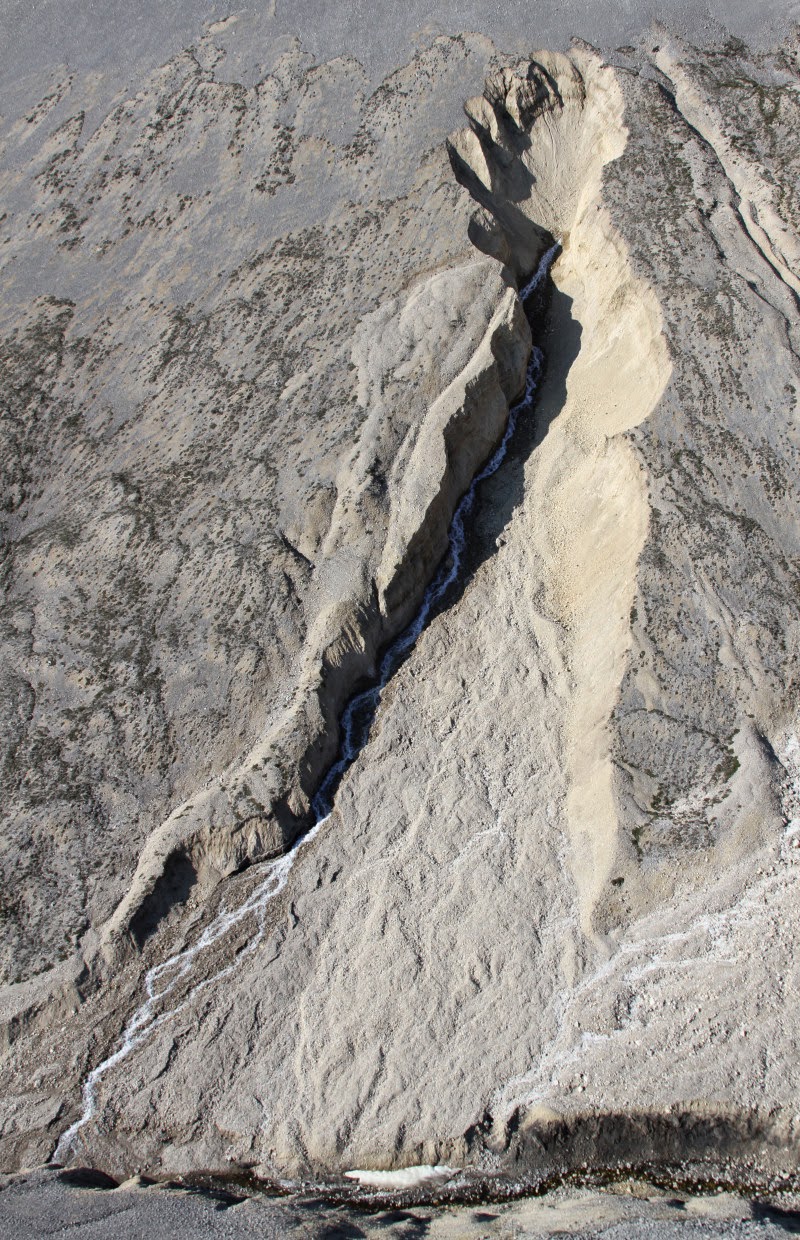
View looking north at the Ice River spring, the highest latitude perennial spring known. Located in the polar desert of northern Ellesmere Island, Nunavut, the high discharge spring carves a gully remarkable similar to those observed on Mars. Credit: Photo by Stephen Grasby
A Canadian team lead by Stephen Grasby reports the discovery of the highest latitude perennial spring known in the world. This high-volume spring demonstrates that deep groundwater circulation through the cryosphere occurs, and can form gullies in a region of extreme low temperatures and with morphology remarkably similar to those on Mars. The 2009 discovery raises many new questions because it remains uncertain how such a high-volume spring can originate in a polar desert environment.
Grasby and colleagues encountered the northernmost perennial spring in the world, which they have dubbed the Ice River Spring, on Ellesmere Island, Nunavut, Canadian High Arctic. The specific study area is north of Otto Fiord in a mountainous region underlain by carbonates of the Nansen Formation. The spring discharges at 300 m elevation from colluvium on a south-facing (21° incline) mountain slope. The unnamed mountain rises 800 m above sea level. Detailed recordings show that this spring flows year-round, even during 24 hours of darkness in the winter months, when air temperatures are as low as minus 50 degrees Celsius.
Detailed geochemistry shows that the waters originate from the surface and circulate down as deep as 3 km before returning through thick permafrost as a spring. This points to a much more active hydrogeological system in polar regions than previously thought possible, which is perhaps driven by glacial meltwater.
Another intriguing feature of the Ice River site is the remarkable similarity to mid-latitude gullies observed on Mars. The discovery of these features on Mars has led to suggestions that recent groundwater discharge has occurred from confined aquifers.
Note : The above story is based on materials provided by Geological Society of America.
Climate change is unlikely to lead to more days of extreme cold, similar to those that gripped the United States in a deep freeze last winter, new research has shown.
The Arctic amplification phenomenon refers to the faster rate of warming in the Arctic compared to places further south. It is this phenomenon that has been linked to a spike in the number of severe cold spells experienced in recent years over Europe and North America.
However, new research by University of Exeter expert Dr James Screen has shown that Arctic amplification has actually reduced the risk of cold extremes across large swathes of the Northern Hemisphere.
The intriguing new study, published in the scientific journal Nature Climate Change, questions growing fears that parts of Europe and North America will experience a greater number, or more severe, extreme cold days over the course of the next century.
Dr Screen, a Mathematics Research Fellow at the University of Exeter, said: “Autumn and winter days are becoming warmer on average, and less variable from day-to-day. Both factors reduce the chance of extremely cold days.”
The idea that there was a link between Arctic amplification and extreme weather conditions became prevalent during the severe winter weather that plagued large areas of the United States in January 2014, leading to major transport disruption, power cuts and crop damage.
In his study, Dr Screen examined detailed climate records to show that autumn and winter temperature variability has significantly decreased over the mid-to-high latitude Northern Hemisphere in recent decades.
He found that this has occurred mainly because northerly winds and associated cold days are warming more rapidly than southerly winds and warm days.
Dr Screen said: “Cold days tend to occur when the wind is blowing from the north, bringing Arctic air south into the mid-latitudes. Because the Arctic air is warming so rapidly these cold days are now less cold than they were in the past.”
Using the latest mathematical climate modelling, Dr Screen has also been able to show that these changes will continue in to the future, with projected future decreases in temperature variability in all seasons, except summer.
Note : The above story is based on materials provided by University of Exeter.
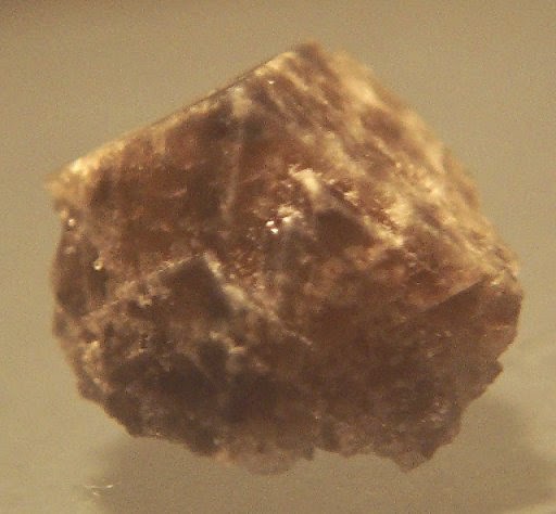
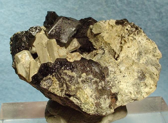
Chemical Formula: Mg3(SiO4)(F,OH)2 Locality: Ostanmosoa iron mine, Norberg, Vastmanland, Sweden. Name Origin: Named after its locality.
Norbergite is a nesosilicate mineral with formula Mg3(SiO4)(F,OH)2. It is a member of the humite group.
It was first described in 1926 for an occurrence in the Ostanmosoa iron mine in Norberg, Västmanland, Sweden, for which it is named. It occurs in contact metamorphic zones in carbonate rocks intruded by plutonic rocks or pegmatites supplying the fluorine. Associated minerals include dolomite, calcite, tremolite, grossular, wollastonite, forsterite, monticellite, cuspidine, fluoborite, ludwigite, fluorite and phlogopite.
History
Discovery date : 1926 Town of Origin : NORBERG Country of Origin : SUEDE
Optical properties
Optical and misc. Properties: Transparent – Translucide – fluorescent Refractive Index: from 1,56 to 1,59 Axial angle 2V: 44-50°
Physical Properties
Cleavage: Distinct Color: White, Yellow, Brown, Red. Density: 3.1 – 3.2, Average = 3.15 Diaphaneity: Transparent to translucent Fracture: Sub Conchoidal – Fractures developed in brittle materials characterized by semi-curving surfaces. Hardness: 6-6.5 – Orthoclase-Pyrite Luminescence: Fluorescent, Short UV=bright yellow. Luster: Vitreous – Resinous Streak: white
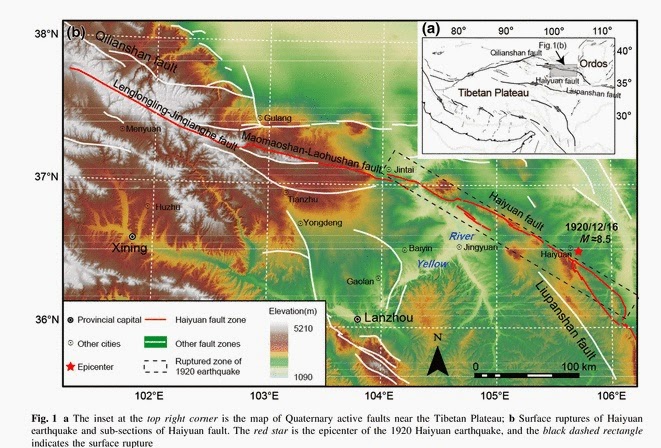
Chinese and American scientists collaborating in the study of an active seismic fault that produced one of China’s most deadly earthquakes say their deployment of an airborne LiDAR system, which uses pulses of laser light to calculate distances and chart terrain features, has helped them produce the most precise topographical measurements ever of the fault zone.
“Light detection and ranging (LiDAR) presents a new approach to build detailed topographic maps effectively,” they report. They add that these high-precision three-dimensional models can be used to illustrate not only land surface changes following past quakes, but also features of past ruptures that could point to the possibility of future temblors.
Experts at the State Key Laboratory of Earthquake Dynamics and at the National Earthquake Infrastructure Service in Beijing, working with a colleague at the United States Geological Survey (USGS) in Pasadena, California, mounted a Leica ALS-60 LiDAR system aboard a Chinese Yun Five aircraft and then began scanning the Haiyuan fault zone in a series of flights over the course of a week. The fault zone is similar to the San Andreas fault in California, which has similarly been scanned and studied as a comparison.
“During the past century,” they explain in a new study, “the Haiyuan fault zone produced two great earthquakes: the M 8.5 Haiyuan earthquake in 1920, along the eastern Haiyuan fault, and the M 8–8.3 Gulang earthquake in 1927.”
“The Haiyuan earthquake of 16 December 1920 is one of the largest intra- continental earthquakes ever documented in history,” they add, “and ruptured about a 237-kilometer-long ground surface, with a maximum left-lateral slip of 10.2 m, and claimed over 220,000 lives.”
In the new study, “Quantitative study of tectonic geomorphology along the Haiyuan fault based on airborne LiDAR,” lead scientist Jing Liu and her colleagues at the Earthquake Dynamics Lab, part of the China Earthquake Administration in Beijing, state their experiments with the LiDAR scanning system and related building of a high-resolution topographical model provide “an example of how LiDAR data may be used to improve the study of active faults and the risk assessment of related hazards.”
Sections of the 3D digital model generated with the LiDAR data are “intensively analyzed to demonstrate tectonic geomorphic feature identification and displacement measurement,” they state. The LiDAR data are also used, for example, to calculate horizontal and vertical coseismic offsets in one section of the fault zone.
LiDAR data can be used to verify measurements made during fieldwork on offsets of tectonic landform features, state co-authors Tao Chen, Pei Zhen Zhang, Jing Liu, Chuan You Li, and Zhi Kun Ren, along with Ken Hudnut at the USGS, who visited the China Earthquake Administration to participate in this study. “The offset landforms are visualized on an office computer workstation easily, and specialized software may be used to obtain fault displacement measurements quantitatively,” they explain.
With LiDAR-generated digital models of the topography across fault zones, the “link between fault activity and large earthquakes is better recognized, as well as the potential risk for future earthquake hazards,” says the team of scientists.
More precise measurements of the active fault zone made possible by the LiDAR system, and their depiction in sophisticated three-dimensional maps, are helping scientists not only in basic research, but also in terms of calculating the probability of a seismic shock recurring, say the co-authors of the new study, which was published online in the journal Chinese Science Bulletin by Science China Press and Springer-Verlag.
Airborne laser swath mapping helps scientists to virtually remove the vegetation covering from topographical models; this “bare earth” representation provides for more accurate identification of tectonic features and changes following a quake.
A LiDAR airborne scanning system of the Earth’s terrain was deployed over the section of the southwestern Chinese province of Sichuan that was the epicenter of a Mw7.9 earthquake that struck in May of 2008; LiDAR data were used to map the scale of landslides and ultimately to develop rescue schemes.
In the new study, the Chinese and American scientists say that digital models created using LiDAR data from the Haiyuan fault zone “have a much higher resolution than existing topographic data and most aerial photographs, allowing us to map the locations of fault traces more accurately than ever.”
The high level of precision of the digital models constructed with information from the LiDAR laser scans of the topography in this fault zone will encourage future “site-specific fault activity studies,” state the scientists.
“In the future,” they predict, “we can expect that more and more concepts or models of fault activity would benefit from this unprecedented survey technique.”
Along the Haiyuan fault zone in the western Chinese province of Gansu, LiDAR scans and related digital models have already been used to identify 600 channels and other linear geomorphic features slated for more comprehensive analysis.
“The next step is to measure the displacements along the whole Haiyuan fault and analyze the principle of the slip distribution,” states the team of scientists, “which would help people better understand the fundamental link between fault activity and large earthquakes and assess potential risk for future earthquake hazards.”
In places where slip during past earthquakes was less pronounced, it is possible that future earthquakes could have greater slip in order to accommodate and equalize motions along the fault system. Alternatively, slip may be large repeatedly in some places and small elsewhere. Such variations in slip may help to assess future hazards, so observations of this kind are very important to answer unresolved questions that are central to research on hazards of earthquake fault zones around the world. More information:
Chinese Science Bulletin July 2014, Volume 59, Issue 20, pp 2396-2409. link.springer.com/article/10.1… %2Fs11434-014-0199-4
Note : The above story is based on materials provided by Science China Press
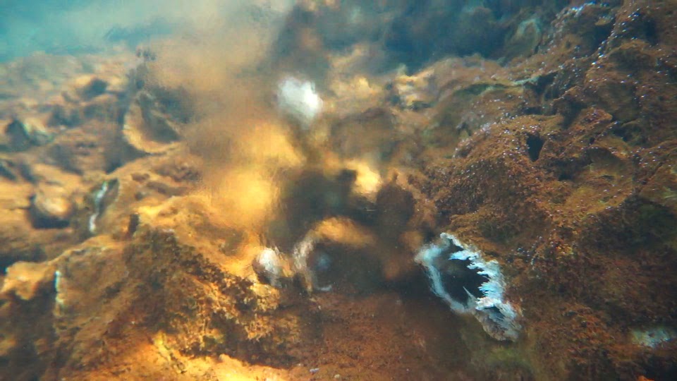
Roy Price first heard about the hydrothermal vents in New Caledonia’s Bay of Prony a decade ago. Being a scuba diver and a geologist, he was fascinated by the pictures of a 38-meter-high calcite “chimney” that had precipitated out of the highly-alkaline vent fluid.
His attraction to this South Pacific site intensified over the years, as it was later revealed that the geochemistry of the hydrothermal fluids discharging in the Bay of Prony resemble that of the mid-Atlantic’s “Lost City,” one of the most spectacular of all hydrothermal vent systems. The unique chemical and biological conditions at the Lost City has led some scientists to speculate that the origin of life may have occurred around similar sorts of vents in the Earth’s distant past.
“The site in New Caledonia is very similar to the Lost City in many ways,” Price said.
Like the Lost City, the water that bubbles out of the Prony vents has an extremely alkaline pH of around 11. Temperatures reach up to 40° C (104° F) in some places, and fluids are highly enriched in dissolved hydrogen (H2) and methane (CH4). Calcium dissolved in the fluids reacts with bicarbonate in seawater, which leads to the formation of tall, monolithic calcite chimneys that look like ruins from an ancient civilization.
Besides having many geochemical similarities, Prony and the Lost City also have similar microbiology, as demonstrated by recent work from the “HYDROPRONY” research group, an interdisciplinary research team affiliated with the Mediterranean Institute of Oceanography (MIO) and the French Institute of Research for Development (IRD).
One big difference, however, is that the Lost City is nearly a kilometer underwater, whereas the main Prony chimney, called “the Needle of Prony” or “l’Aiguille” in French, nearly breaches the water surface, making the site accessible to divers.
Price, who is now a researcher at the School of Marine and Atmospheric Sciences, State University of New York, Stony Brook, asked the HYDROPRONY group for permission to join them on a field expedition in April 2014. His motivation was to test whether the Prony vents can produce organic compounds abiotically, without any biological influence.
“The abiotic production of hydrocarbons and other simple organic compounds in places such as these may have led or at least contributed to abiogenesis—the [long-ago] switch from abiotic chemical reactions to biologically-mediated reactions probably similar to today’s microbial metabolisms,” Price said.
With funding from a NASA Early Career Collaboration award, Price flew to New Caledonia to test whether the chemical precursors of this ancient switch can be found in Prony Bay.
Early Earth analog
As soon as he arrived on New Caledonia, Price was struck by the red soil that covers the southern part of the main island. This soil comes from the erosion of ultramafic rock, which is a rare type of iron-rich, silica-poor rock, only found in a few places on earth today.
Ultramafic rocks give rise to the hydrothermal vents in both Prony Bay and the Lost City. When exposed to water, ultramafic rocks go through a chemical weathering process called serpentinization. Specifically, the iron in the rock oxidizes, producing hydrogen gas (H2), as well as heat. The hydrogen reacts with carbon dioxide in the water to produce one of the simplest organic molecules, methane (CH4).
“This is a key point—an organic compound produced without any biological interactions whatsoever,” Price explained. “Other slightly more complex organic molecules can also be produced abiotically.”
Ultramafic rocks are not very common on the Earth’s surface now, so it’s rare to find areas with ongoing serpentinization. But billions of years ago when life was getting its start, “ultramafic rocks may have been much more abundant,” Price said. The Earth was much hotter back then, allowing more iron-rich (ultramafic-producing) lava to flow up from the mantle to the crust.
One might imagine, then, that the first precursors to life took advantage of the conditions around these types of hydrothermal vents, co-opting the geochemical reactions to form their own “biological serpentinization” that extracted energy from the reduction of carbon dioxide with hydrogen, forming methane in the process.
Price’s experiments in New Caledonia could provide some ground truth for these origin-of-life speculations. The methane and hydrogen in the hydrothermal fluids from Prony will be analyzed in the lab to determine their carbon and hydrogen isotopic abundances. If the vent’s methane is enriched in carbon-13 and depleted in deuterium (heavy hydrogen), that could be evidence of abiotic production.
“If the methane is produced abiotically, then we will have in the Prony hydrothermal site an early Earth analog which may help us understand the complex sequence of events which led to the origin of life,” Price said.
Fielding an answer
In the days leading up to his first dive, Price spoke with several IRD researchers, including Bernard Pelletier and Claude Payri, the investigators who recently ‘rediscovered’ the hydrothermal cones in the Bay of Prony.
On April 16, Price met the diving leader, Eric Folcher of IRD, who drove him out to the boat launch on the bay. They were joined in the field by two members of the HYDROPRONY group—microbiologists Gaël Erauso of the Mediterranean Institute of Oceanography (University of Marseille) and Mylène Hugoni of the University Blaise Pascal. They are studying the genetic make-up of the microbes and viruses that inhabit the vent environments.
“The weather was particularly good this day, lacking the nearly constant wind the island experiences,” Price recounted. “This not only meant a very smooth ride out to the Needle, but also hinted that there would be very good visibility during the dive.”
When the team’s boat pulled into position, Price caught his first glimpse of the Needle, with its mineral-crusted dome clearly visible about 3 meters below the surface.
Price prepared his sampling equipment, which included several gas-tight syringes to syphon fluids discharging from the vents. When he and Folcher dived in the water, they were immediately surprised by a swarm of moon jellyfish.
“Within my field of view at the surface, I could see dozens of these stinging medusa,” Price said.
The top of the Needle has no active venting, so the divers swam down the side of the chimney to a depth of about 12 meters (39 feet), where they began to see white-tipped, cone-like structures out of which hydrothermal fluids flow.
The water coming out of the vents is fresh, not salty, causing it to shimmer when it mixes with the surrounding seawater. The vent fluid is fresh because it originates from rainwater, which percolates down through the rocks on the island. This water then reacts with the rocks by the serpentinization reactions described earlier, and finally drains down beneath the bay before discharging at the Needle and other areas in and around the bay.
This freshwater distinguishes the Prony hydrothermal field from other sites such as Lost City, which are fed with saltwater. Another unique feature of Prony is that it is in the photic zone, where sunlight can reach the microbial communities, as it does in terrestrial hot springs.
“All this suggests that Prony is a hybrid vent system, with geochemical and microbial characteristics similar to both terrestrial and marine systems,” Price said.
The divers approached a striking cone-like structure at approximately 16 meters (52 feet) deep to obtain samples. A temperature reading showed that the exiting fluids were about 33° C (91° F), which is 8 to 9°C higher than the ambient seawater. The fluids are heated by the serpentinization process, rather than the volcanic processes that power other vents.
The venting is very slow, so it took Price about 10 minutes to fill just one of his 50-milliliter syringes with vent fluid while preventing seawater from being sucked in as well. Maintaining position in the water during this filling procedure was one of the main challenges on this diving expedition.
“We cannot touch the cone, for fear of breaking it or crushing some of the reef organisms,” he said. “For a scuba diver, having the ability to hang in the water column like this takes a lot of practice, and it is not so easy. I use my breathing to maintain my position. If I’m dropping a little too low, I’ll take a slightly deeper breath. The air in my lungs then raises me a little. Too much and I breath out, which drops me back into position.”
With an hour of dive time, Price managed to collect five syringes of hydrothermal fluids. Back on the boat, he “fixed” the samples so that their geochemical properties wouldn’t begin evolving inside the sample tubes. He measured a pH of 10.1 in the samples, which is one of the highest values obtained for these submarine vents. Full analysis will occur later in the lab.
Spring loading
In addition to the syringe samples, the researchers also needed to collect larger volume samples in order to ‘capture’ organisms living in this unique environment. Erauso and Hugoni plan to do a thorough DNA survey in order to catalogue the diversity of species, and perhaps cultivate unidentified microorganisms, including Archaea, who thrive in these very alkaline environments.
For this biological research, the team collected mineral precipitates, where these vent organisms might be living. Underwater, the divers also installed a funnel above one vent in order to concentrate the discharge into a large plastic bag. The goal was to collect around 40 liters of fluid, which could then be filtered to remove microbes and viruses. However, the low flow rate posed a problem in filling the large bags.
The team had better luck at two nearby hot springs, the Bain des Japonais Spring and the Rivière des Kaoris Spring. Both of these sites are intertidal, located right on the coast of the Bay of Prony, where they get covered by seawater in high tide.
The Japonais site consists of a handful of outcroppings, which are shorter versions of the chimneys found in the middle of bay. At low tide, hydrothermal fluid discharges from the depths without much mixing with seawater. The team found that this ‘pristine’ fluid had a temperature 41° C (106° F) and a pH of 11.2, giving some indication of the geochemical characteristics of the subsurface fluids.
The Kaoris Spring is at the mouth of a stream that empties into Prony Bay. It consists of a large terrace, where warm hydrothermal fluid helps to support a variety of microbial biofilms. The researchers collected 40 liters of the fluids along with some slices of these biofilms.
Primordial soup kitchens
The samples from the Needle and the two intertidal hot springs are currently being analyzed, and Price plans to use the results in an upcoming NASA Exobiology proposal, which aims to give the first detailed carbon cycling geochemistry from the Prony hydrothermal field.
“The more I think about it, the more I wonder about systems like this on the early Earth,” Price said. “Today, groundwater that reacts with underlying rocks can be seen discharging along the coastlines everywhere around the world. This phenomenon must have occurred on the early Earth, but [back then] many of the rocks would have been ultramafic.”
Hybrid, Prony-like systems may therefore have been very common during our planet’s beginnings, Price said. They may also have existed on Mars and other planetary bodies in our solar system.
“Based on our current understanding of the early Earth, these types of transitional environments could have been highly important for origin of life scenarios,” Price said.
Note : The above story is based on materials provided by Astrobio.net
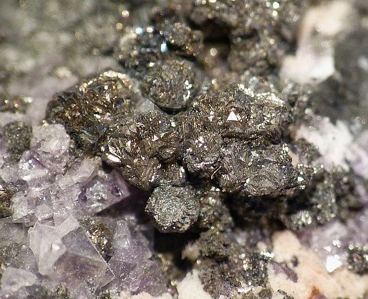
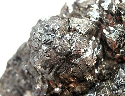
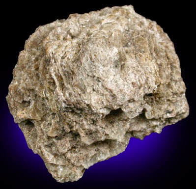
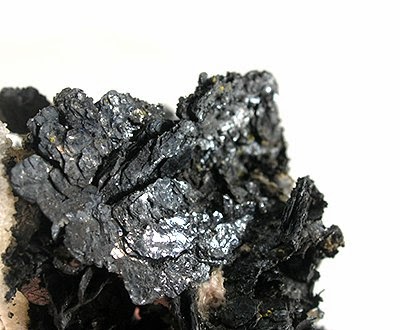
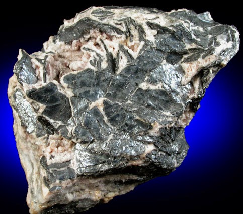
Chemical Formula: (Ni,Co)As3-x Locality: Schneeberg, Saxony, Germany. Name Origin: Named as the nickel-rich version of skutterudite.
Skutterudite is a cobalt arsenide mineral that has variable amounts of nickel and iron substituting for cobalt with a general formula: (Co,Ni,Fe)As3. Some references give the arsenic a variable formula subscript of 2-3. High nickel varieties are referred to as nickel-skutterudite, previously chloanthite. It is a hydrothermal ore mineral found in moderate to high temperature veins with other Ni-Co minerals. Associated minerals are arsenopyrite, native silver, erythrite, annabergite, nickeline, cobaltite, silver sulfosalts, native bismuth, calcite, siderite, barite and quartz. It is mined as an ore of cobalt and nickel with a by-product of arsenic.
The crystal structure of this mineral has been found to have important technological uses for several compounds isostructural with the mineral.
The mineral has a bright metallic luster, and is tin white or light steel gray in color with a black streak. The specific gravity is 6.5 and the hardness is 5.5-6. Its crystal structure is isometric with cube and octahedron forms similar to that of pyrite. The arsenic content gives a garlic odor when heated or crushed.
It was discovered in Skuterud Mines, Modum, Buskerud, Norway, in 1845. Smaltite is a synonym for the mineral. Notable occurrences include Cobalt, Ontario, Skuterud, Norway, and Franklin, New Jersey in the United States. The rare arsenide minerals are classified in Dana’s sulfide mineral group, even though it contains no sulfur.
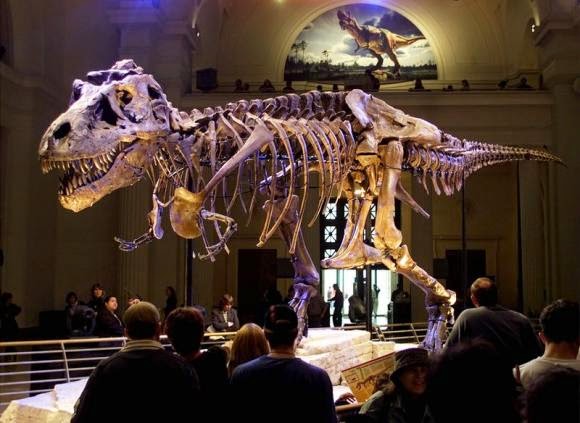
The dinosaur named ”Sue,” a 41-foot-long Tyrannosaurus rex, is shown on display at the Field Museum in Chicago, Illinois in this May 17, 2000 file photo. Credit: Reuters/Sue Ogrocki/Files
The hot question of whether dinosaurs were warm-blooded like birds and mammals or cold blooded like reptiles, fish and amphibians finally has a good answer.
Dinosaurs, for eons Earth’s dominant land animals until being wiped out by an asteroid 65 million years ago, were in fact somewhere in between.
Scientists said on Thursday they evaluated the metabolism of numerous dinosaurs using a formula based on their body mass as revealed by the bulk of their thigh bones and their growth rates as shown by growth rings in fossil bones akin to those in trees.
The study, published in the journal Science, assessed 21 species of dinosaurs including super predators Tyrannosaurus and Allosaurus, long-necked Apatosaurus, duckbilled Tenontosaurus and bird-like Troodon as well as a range of mammals, birds, bony fish, sharks, lizards, snakes and crocodiles.
“Our results showed that dinosaurs had growth and metabolic rates that were actually not characteristic of warm-blooded or even cold-blooded organisms. They did not act like mammals or birds nor did they act like reptiles or fish,” said University of Arizona evolutionary biologist and ecologist Brian Enquist.
“Instead, they had growth rates and metabolisms intermediate to warm-blooded and cold-blooded organisms of today. In short, they had physiologies that are not common in today’s world.”
There has been a long-standing debate about whether dinosaurs were slow, lumbering cold-blooded animals – as scientists first proposed in the 19th century – or had a uniquely advanced, more warm-blooded physiology.
As scientists unearthed remains of more and more fast-looking dinosaurs like Velociraptor, some championed the idea dinosaurs were as active and warm–blooded as mammals and birds. The realization that birds arose from small feathered dinosaurs seemed to support that view.
University of New Mexico biologist John Grady said the idea that creatures must be either warm-blooded or cold-blooded is too simplistic when looking over the vast expanse of time. Like dinosaurs, some animals alive today like the great white shark, leatherback sea turtle and tuna do not fit easily into either category, Grady added.
“A better answer would be ‘in the middle.’ By examining animal growth and rates of energy use, we were able to reconstruct a metabolic continuum, and place dinosaurs along that continuum. Somewhat surprisingly, dinosaurs fell right in the middle,” Grady said.
The researchers called creatures with this medium-powered metabolism mesotherms, as contrasted to ectotherms (cold–blooded animals with low metabolic rates that do not produce much heat and bask in the sun to warm up) and endotherms (warm–blooded animals that use heat from metabolic reactions to maintain a high, stable body temperature).
Grady said an intermediate metabolism may have allowed dinosaurs to get much bigger than any mammal ever could. Warm–blooded animals need to eat a lot so they are frequently hunting or munching on plants. “It is doubtful that a lion the size of T. rex could eat enough to survive,” Grady said.
Note : The above story is based on materials provided by Will Dunham; Editing by Marguerita Choy “Reuters”
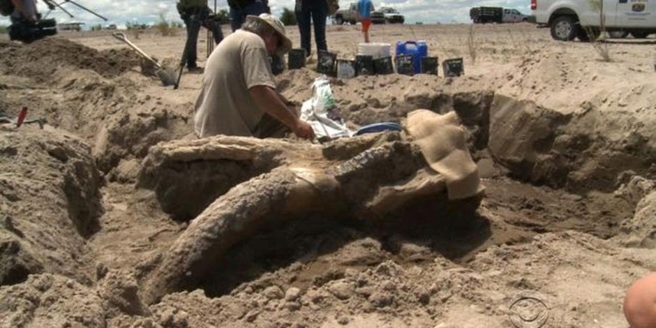
A group of men attending a bachelor party stumbled across a rare fossil of a mastodon skull, complete with its tusks, in sand at a lakeshore in a New Mexico state park, a museum spokesman said on Thursday.
Randall Gann of the New Mexico Museum of Natural History and Science said the partygoers discovered the fossil earlier this week in Elephant Butte State Park, an area of arid hills surrounding a reservoir about 155 miles (250 km) south of Albuquerque.
He said the museum’s head paleontologist was amazed by the find, calling it “the most complete mastodon skull with attached tusks he has seen in 20 years.”
Mastodons were Ice Age relatives of the elephant that stood 10 feet (3 meters) tall and migrated to North America some 15 million years ago. They ranged across the continent with saber tooth tigers, giant sloths and American camels, before becoming extinct about 10,000 years ago.
The revelers who made the discovery first contacted a professor at the University of New Mexico, who then put them in touch with the museum’s head paleontologist Gary Morgan.
Gann said scientists from the museum planned to act quickly.
“Because it is in sand and not buried in rock, Dr. Morgan feels he can excavate the skull, cast it, and remove it today,” the spokesman said.Shannon Parill, an employee of Elephant Butte State Park, said it was surprising the fossil was found in such a popular area, which attracts thousands of outdoor enthusiasts every year with its boating, hiking, fishing and camping opportunities.
Beth Wojahn, spokeswoman for New Mexico’s Energy, Minerals and Natural Resources Department, praised the group involved.
“What is noteworthy is the men who found the skull did not disturb it and called the right people,” Wojahn said.
Note : The above story is based on materials provided by Daniel Wallis and Will Dunham ” Reuters “
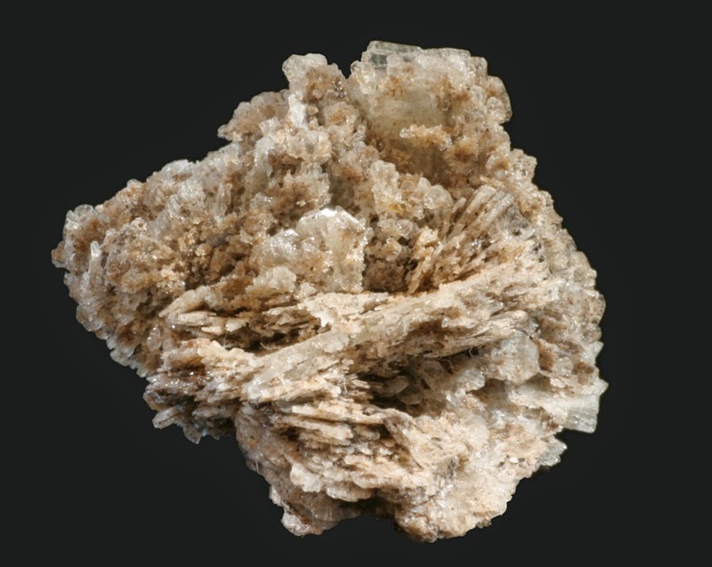
Chemical Formula: Mg(HPO4)·3H2O Locality: Skipton lava tube caves, 40 km southwest of Ballarat, Victoria, Australia. Name Origin: Named for James Cosmo Newbery (1843-1895), geologist, Melbourne, Australia, who initially found the mineral.
History
Discovery date : 1879 Town of Origin: GROTTES DE SKIPTON, BALLARAT, VICTORIA Country of Origin: AUSTRALIE
Optical properties
Optical and misc. Properties : Fragile, cassant – Transparent Refractive Index: from 1,51 to 1,53 Axial angle 2V : 45°
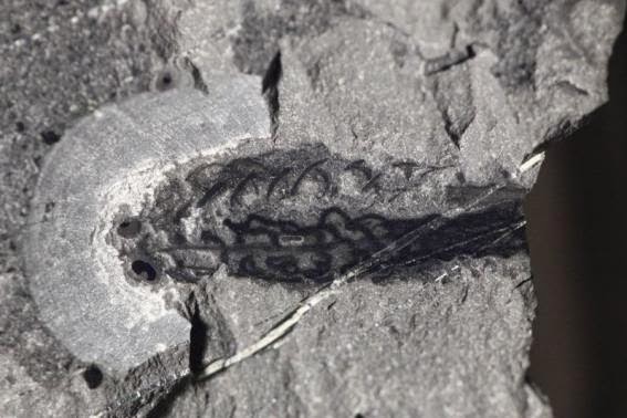
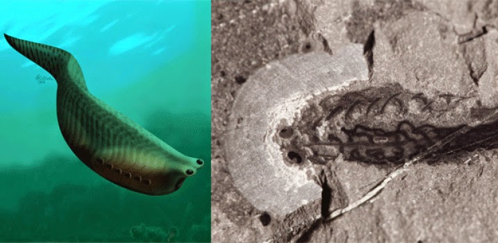
Metasprigina fossil from Marble Canyon, which lived about 514 to 505 million years ago during the Cambrian period is shown in this handout image. Credit: Reuters/Jean-Bernard Caron/ROM/Handout via Reuters
This is certainly not just another fish tale.
A tiny jawless fish that lived more than half a billion years ago is providing scientists with a treasure trove of information about the very dawn of vertebrate life on Earth.
Researchers on Wednesday described about 100 fossil specimens of the fish unearthed at the Burgess Shale site in the Canadian Rockies and other locales, many exquisitely preserved showing the primitive body structures that would later evolve into jaws.
The fish, Metaspriggina, lived about 515 to 500 million years ago amid the astonishing flourishing of complex life during the Cambrian Period. While two fragmentary specimens had been found previously, the new ones revealed unprecedented detail about one of the earliest known vertebrates.
Creatures like Metaspriggina began the lineage of vertebrates – animals with backbones – that later would include the whole range of jawed fishes, amphibians, reptiles, birds and mammals including people.
“It allows an understanding of where we come from and what our most distant relatives might have looked like,” said Jean-Bernard Caron, a paleontologist at the Royal Ontario Museum in Toronto. “Because of its great age – more than half a billion year old – Metaspriggina provides a deep down view at the origins of the vertebrates.”
Metaspriggina was a soft-bodied jawless fish no bigger than a person’s thumb – about 2-1/2 inches (6 cm) long, with a small head, a narrow, tapering body, a pair of large eyes atop the head and a pair of small nasal sacs.
It did not have bones but possessed a skull possibly made of cartilage as well as precursors to vertebrae and a skeletal rod called a “notochord” that provided body support like backbones would do in later vertebrates. It is unclear if it had fins.
The scientists were especially excited about the gill structure of the fish because of the preview it gives to the anatomy of later vertebrates – paving the way for the jaws that would open a world of possibilities for so many later creatures.
Metaspriggina boasted seven pairs of rod-like structures called gill arches, or branchial arches, that functioned for both filtration of food particles and respiration. The first pair of these gill arches was more robust than the others and presaged the first step in the evolution of jaws, Caron said.
Scientists have known about the importance of these arches in the evolution of vertebrates but had never before been able to see such an early example.
“Metaspriggina is important because it both fills an important gap in our understanding of the early evolution of the group to which we belong, but in particular shows with remarkable clarity the arrangement of the so-called branchial arches,” University of Cambridge paleontologist Simon Conway Morris said.
Part of the jaw bones eventually evolved into tiny middle ear bones in mammals, Caron added, noting that the evolution of these arches “had a profound impact on how vertebrates look, live and function today.”
The study was published in the journal Nature.
Note : The above story is based on materials provided by Will Dunham; Editing by Tom Brown ” Reuters”
Three-quarters of the Earth’s water may be locked deep underground in a layer of rock, scientists say. Photograph: Blue Line Pictures/Getty Images
After decades of searching scientists have discovered that a vast reservoir of water, enough to fill the Earth’s oceans three times over, may be trapped hundreds of miles beneath the surface, potentially transforming our understanding of how the planet was formed.
The water is locked up in a mineral called ringwoodite about 660km (400 miles) beneath the crust of the Earth, researchers say. Geophysicist Steve Jacobsen from Northwestern University in the US co-authored the study published in the journal Science and said the discovery suggested Earth’s water may have come from within, driven to the surface by geological activity, rather than being deposited by icy comets hitting the forming planet as held by the prevailing theories.
“Geological processes on the Earth’s surface, such as earthquakes or erupting volcanoes, are an expression of what is going on inside the Earth, out of our sight,” Jacobsen said.
“I think we are finally seeing evidence for a whole-Earth water cycle, which may help explain the vast amount of liquid water on the surface of our habitable planet. Scientists have been looking for this missing deep water for decades.”
Jacobsen and his colleagues are the first to provide direct evidence that there may be water in an area of the Earth’s mantle known as the transition zone. They based their findings on a study of a vast underground region extending across most of the interior of the US.
Ringwoodite acts like a sponge due to a crystal structure that makes it attract hydrogen and trap water.
If just 1% of the weight of mantle rock located in the transition zone was water it would be equivalent to nearly three times the amount of water in our oceans, Jacobsen said.
The study used data from the USArray, a network of seismometers across the US that measure the vibrations of earthquakes, combined with Jacobsen’s lab experiments on rocks simulating the high pressures found more than 600km underground.
It produced evidence that melting and movement of rock in the transition zone – hundreds of kilometres down, between the upper and lower mantles – led to a process where water could become fused and trapped in the rock.
The discovery is remarkable because most melting in the mantle was previously thought to occur at a much shallower distance, about 80km below the Earth’s surface.
Jacobsen told the New Scientist that the hidden water might also act as a buffer for the oceans on the surface, explaining why they have stayed the same size for millions of years. “If [the stored water] wasn’t there, it would be on the surface of the Earth, and mountaintops would be the only land poking out,” he said.
Note : The above story is based on materials provided by Melissa Davey For The Guardian
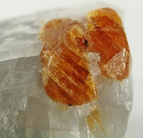
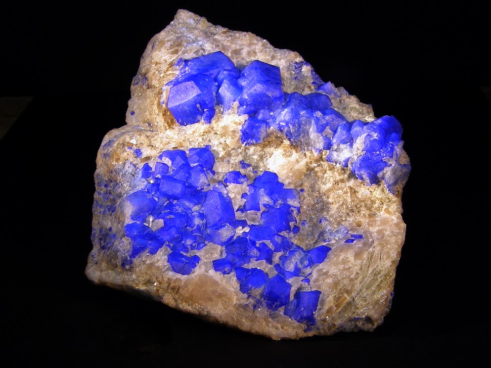
Chemical Formula: Na2KLi(Fe2+,Mn2+)2Ti2(Si8O24) Locality: Benitoite mine, San Benito, Co., California, USA. Name Origin: Named for Neptune, the Roman god of the sea, because it was found with aegirine, named for the Scandinavian god of the sea.
Neptunite is a silicate mineral with the formula Na2KLi(Fe2+,Mn2+)2Ti2(Si8O24). With increasing manganese it forms a series with mangan-neptunite. Watatsumiite is the variety with vanadium replacing the titanium in the formula.
It was first described in 1893 for an occurrence in the Narssârssuk pegmatite of West Greenland. It is also found within natrolite veins in glaucophane schist within serpentinite in San Benito County, California, USA. It also occurs in Mont Saint-Hilaire, Quebec and in the Kola Peninsula of Russia.
The mineral is named for Neptune, Roman god of the sea because of its association with aegirine from Àgir, the Scandinavian sea-god.
The Gemological Institute of America (GIA) identified an 11.78-carat faceted specimen as neptunite based on Raman spectroscopy.
History
Discovery date : 1893 Town of Origin : NARNARSUK Country of Origin: GROENLAND
Optical properties
Optical and misc. Properties: Translucide – Opaque Refractive Index: from 1,69 to 1,73 Axial angle 2V : ~40°
Physical Properties
Cleavage: {110} Good Color: Black, Red. Density: 3.23 Diaphaneity: Translucent Fracture: Conchoidal – Fractures developed in brittle materials characterized by smoothly curving surfaces, (e.g. quartz). Hardness: 5-6 – Between Apatite and Orthoclase Luminescence: Non-fluorescent. Luster: Vitreous (Glassy) Streak: brown
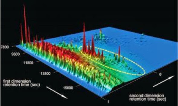
Researchers used comprehensive two-dimensional gas chromatography (GCxGC) in their oil spill forensics to measure levels of degradation in biomarkers. THe biomarkers here are shown inside the dotted line. Credit: Christoph Aeppli, Bigelow Laboratory for Ocean Sciences
Years after the 2010 Deepwater Horizon Oil spill, oil continues to wash ashore as oil-soaked “sand patties,” persists in salt marshes abutting the Gulf of Mexico, and questions remain about how much oil has been deposited on the seafloor. Scientists from Woods Hole Oceanographic Institution and Bigelow Laboratory for Ocean Sciences have developed a unique way to fingerprint oil, even after most of it has degraded, and to assess how it changes over time. Researchers refined methods typically used to identify the source of oil spills and adapted them for application on a longer time frame to successfully identify Macondo Well oil, years after the spill.
“We were looking at two questions: how could we identify the oil on shore, now four years after the spill, and how the oil from the spill was weathering over time,” explained Christoph Aeppli, Senior Research Scientist at Bigelow Laboratory for Ocean Sciences in East Boothbay, Maine, and lead author of the study reported in Environmental Science & Technology. Aeppli worked with his then-colleagues at Woods Hole Oceanographic Institution, and University of California, Santa Barbara on the investigation and report.
Researchers used comprehensive two-dimensional gas chromatography (GCxGC) in their oil spill forensics to measure levels of degradation in biomarkers. Biomarkers are molecular fossils. Each reservoir has specific amounts of different biomarkers, so oil biomarkers serve as identifiers much like human fingerprints. Biomarkers are usually recalcitrant in reservoirs, but when exposed for a long time to the environment, some are altered due to natural processes. Oil consists of tens of thousands of compounds, and many of them can be degraded by bacteria or broken down by sunlight. This research was designed to determine the resiliency of specific biomarkers and to see how they held up when exposed to environmental conditions on shore.
“We found that some biomarkers — homohopanes and triaromoatic steroids (TAS), specifically — degraded within a few years following the Deepwater Horizon spill,” said Chris Reddy, a scientist at Woods Hole Oceanographic Institution and co-author of the paper. “These biomarkers are not as resilient as once thought and they may provide a future window into determining how much, and how quickly, these oil components may linger in the environment when exposed to air, sunlight, and the elements.”
Researchers sought to determine the specific source of the biomarkers degradation. Through analysis of oil-soaked “sand patties” collected along the Gulf shore over a 28-month period, they found that most biomarker compounds were recalcitrant and could be used to identify DWH oil. Some biomarkers, however, degraded. “This knowledge is helping us improve our oil spill forensics. It is providing a foundation for better, longer-term identification techniques that account for exposure of oil to wind, waves, sunlight, and microbial degradation over long times,” added Aeppli.
Aeppli, Reddy and colleague Dave Valentine from UC Santa Barbara will apply this new oil fingerprinting technique to process tens of thousands of samples collected shortly after the DWH spill.
Note : The above story is based on materials provided by Bigelow Laboratory for Ocean Sciences.
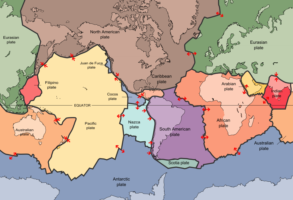
The tectonic plates of the world were mapped in the second half of the 20th century. usgs
Two studies show that the movement rate of plates carrying Earth’s crust may not be constant over time. This could provide a new explanation for the patterns observed in the speed of evolution and has implications for the interpretation of climate models. The work is presented today at Goldschmidt 2014, the premier geochemistry conference taking place in Sacramento, California, USA.
Earth’s continental crust can be thought of as an archive of Earth’s history, containing information on rock formation, the atmosphere and the fossil record. However, it is not clear when and how regularly crust formed since the beginning of Earth history, 4.5 billion years ago.
Researchers led by Professor Peter Cawood, from the University of St. Andrews, UK, examined several measures of continental movement and geologic processes from a number of previous studies. They found that, from 1.7 to 0.75 billion years ago (termed Earth’s middle age), Earth appears to have been very stable in terms of its environment, with little in the way of crust building activity, no major fluctuations in atmospheric composition and few major developments seen in the fossil record. This contrasts markedly with the time periods either side of this, which contained major ice ages and changes in oxygen levels. Earth’s middle age also coincides with the formation of a supercontinent called Rodinia, which appears to have been stable throughout this time.
Professor Cawood suggests this stability may have been due to the gradual cooling of Earth’s crust over time. “Before 1.7 billion years ago, the Earth’s crust would have been substantially hotter, meaning that continental plate movement may have been governed by different rules to those that operate today,” said Professor Cawood. “0.75 billion years ago, the crust reached a point where it had cooled sufficiently to allow modern day plate tectonics to start working, in particular allowing subduction zones to form (where one plate of the crust moves under another). This increase in activity could have kick-started a myriad of changes including the break-up of Rodinia and changes to levels of key elements in the atmosphere and seas, which in turn may have induced evolutionary changes in the life forms present.”
This view is backed up by work from Professor Kent Condie from New Mexico Tech, USA, which suggests the movement rate of Earth’s crust is not constant but may be speeding up over time. Professor Condie examined how supercontinents assemble and break up. “Our results challenge the view that the rate of plate movement is stable over time,” said Professor Condie. “The interpretation of data from many other disciplines such as stable isotope geochemistry, palaeontology and paleoclimatology in part rely on the assumption that the movement rate of the Earth’s crust is constant.”
Results from these fields may now need to be re-examined in light of Condie’s findings. “We now urgently need to collect further data on critical time periods to understand more about the constraints on plate speeds and the frequency of collision between continental blocks,” concluded Professor Condie.
Note : The above story is based on materials provided by European Association of Geochemistry.
Chemical Formula: (Na,K)AlSiO4 Locality: Magnet Cove, Magnet Cove, Ouachita Mountains, Hot Spring County, Arkansas, USA. Name Origin: From the Greek nephele, “cloud,” because it becomes clouded when put in strong acid.
Nepheline, is a feldspathoid: a silica-undersaturated aluminosilicate, Na3KAl4Si4O16, that occurs in intrusive and volcanic rocks with low silica, and in their associated pegmatites.
Nepheline crystals are rare and belong to the hexagonal system, usually having the form of a short, six-sided prism terminated by the basal plane. The unsymmetrical etched figures produced artificially on the prism faces indicate, however, that the crystals are hemimorphic and tetartohedral, the only element of symmetry being a polar hexad axis. It is found in compact, granular aggregates, and can be white, yellow, gray, green, or even reddish (in the eleolite variety). The hardness is 5.5 – 6, and the specific gravity 2.56 – 2.66. It is often translucent with a greasy luster.
History
Discovery date : 1801 Town of Origin : MONTE SOMMA, MT. VESUVE (VOLCAN), NAPLES, CAMPANIE Country of Origin : ITALIE
Optical properties
Optical and misc. Properties: Transparent – Opaque – Translucide Refractive Index: from 1,52 to 1,54
Physical Properties
Cleavage: {1010} Poor Color: White, Gray, Brown, Brownish gray, Reddish white. Density: 2.55 – 2.65, Average = 2.59 Diaphaneity: Transparent to translucent to opaque Fracture: Sub Conchoidal – Fractures developed in brittle materials characterized by semi-curving surfaces. Hardness: 6 – Orthoclase Luminescence: Non-fluorescent. Luster: Vitreous – Greasy Streak: white
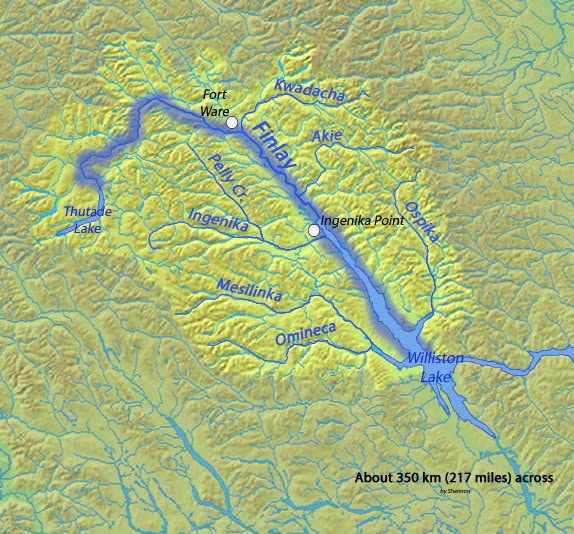
The Finlay River is a 402 km long river in north-central British Columbia flowing north and thence south from Thutade Lake in the Omineca Mountains to Williston Lake, the impounded waters of the Peace River formed by the completion of the W.A.C. Bennett Dam in 1968. Prior to this, the Finlay joined with the Parsnip River to form the Peace. The headwaters of the Finlay at Thutade Lake are considered the ultimate source of the Mackenzie River. Deserters Canyon is located just north of Williston Lake.
The Finlay drains an area of 43,000 square kilometres and discharges at a mean rate of 600 cubic metres per second. Major tributaries of the Finlay include the Ospika, Ingenika, Warneford, Fox, Toodoggone, and Firesteel Rivers (the Ospika now enters Lake Williston directly, however). Located in a remote part of the province, there are no population centres along the river, however, there is a small First Nations community, Fort Ware, located at the junction of the Finlay and Warneford. Tatlatui Provincial Park protects the area of the Tatlatui Range, where Thutade Lake is located.
Map of the Stikine Territory. The line of the Finlay River is the southeast boundary of the territory, which was absorbed into the Colony of British Columbia in 1863.
The Finlay River is named for the explorer John Finlay, who travelled a short way up the river in 1797. The first European to journey its length to its source was the fur trader and explorer Samuel Black in 1824. The river was the eastern half of the northern boundary of the Colony of British Columbia at the time of its creation in 1858, north of which was the North-Western Territory; the western half of the boundary was the Nass River and from 1862 to 1863 it was briefly the southern boundary of the Stickeen Territories (Stikine Territory) which had been formed from the North-Western Territory in response to the Peace and Stikine Gold Rushes and which was amalgamated with the Colony of British Columbia in the following year.
Note : The above story is based on materials provided by Wikipedia
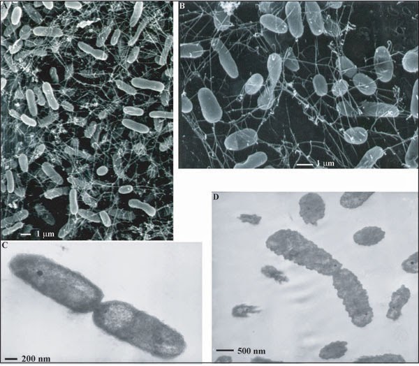
Photomicrographs of a subseafloor thermophile isolated from deep-sea hydrothermal vent fluids. This organism eats sulfur and hydrogen and fixes its own carbon from carbon dioxide. (A, B) Scanning electron micrographs, and (C, D) transmission electron micrographs thin sections. Image courtesy of Julie Huber.
The subseafloor is home to over 1/3 of the bacteria on the planet, but up until recently it was unclear if this huge microbial biosphere was alive and dividing. Now the same group that demonstrated this activity has shown that bacteria from the hostile sea-floor environment have adapted by over-activating stress response and DNA-repair mechanisms, to cope with the harsh conditions.
Subseafloor sediment contains Earth’s largest habitat for microbial life — over 1/3 of all the planets microbial biomass. By drilling deep into the sea floor and taking samples, it can be proven that the subseafloor contains a variety of microbial lifeforms, but it’s only in the last year that researchers have proven that sea floor microbes are actually active in in their natural sea-bed situation — it is difficult to analyse lifeforms which live hundreds of metres below the sea surface because of their low activity levels. A group of researchers at Woods Hole Oceanographic Institute and University of Delaware developed techniques to analyse the messenger
RNA (mRNA) molecules produced by subseafloor microbes. Unlike DNA, which is a fairly robust molecule that can survive intact for thousands of years under certain conditions, mRNA (messenger RNA) has a short half-life. It is produced by cells, which are “turning on” genes, so it is an indication that genes are active. This means that mRNA can be used as evidence (a proxy) for present biological activity.
Lead researcher William Orsi said: “This is the largest microbial biosphere on Earth, composed of cells living deep beneath the surface. We have recently shown for the first time that these cells, the “deep biosphere,” are actually dividing and not in a dormant state. This means that the deep biosphere is active and due to its sheer size likely plays an important role in global elemental cycles over geological timescales.” Now in a presentation to the Goldschmidt conference in Sacramento, California, Dr Orsi will detail just how these seabed bacteria had managed to survive in such an inhospitable environment.
“It’s a really difficult environment to study, so understanding how microbes survive there has been a puzzle” he said, “but we have discovered that they ramp-up some coping mechanisms which have helped them adapt to this stressful environment, where they exist under high pressure and are starved of nutrients.”
The group sampled drill cores from the continental shelf off the coast of Peru. They compared gene expression at several depths spanning 5-159 meters below the seafloor. They found that the expression of DNA repair genes, such as recA, increases with the amount of time the microbes have been buried in the seafloor.
Dr Orsi continued: “Subseafloor microbes have adapted to live in especially harsh conditions. We found that they significantly overexpress genes involved in cellular stress responses like recA. This gene is a central to the bacterial “SOS response,” which is a way bacteria cope with many different environmental stressors including antibiotics. We have found that subseafloor microbes increasingly express this gene with time after they become “buried alive” in the subseafloor.”
“High-throughput omics techniques are proving to have a range of applications in sedimentary systems. For example, marine sedimentary paleogenomics is a new field, which is opening windows into the past effects of climate on marine life. Dr Marco Coolen is the leader of this new field, and we worked together to analyse ancient plankton DNA from the Black Sea. We showed that it opened to the oceans around 9,600 years ago and that historical large-scale climate changes had a significant effect on marine plankton. These techniques are difficult, but they can tell us how biology responds to climate changes over geological timescales. Looking into the past can help us predict the future effects of climate change on marine life.”
Note : The above story is based on materials provided by European Association of Geochemistry.
Chemical Formula: Pb5Au(Te,Sb)4S5-8 Locality: Nagyag mine (now Sacaramb), Romania. Name Origin: Named after the locality.
Nagyágite (Pb5Au(Te,Sb)4S5-8) is a rare sulfide mineral with known occurrence associated with gold ores. Nagyágite crystals are opaque, monoclinic and dark grey to black coloured.
It was first described in 1845 for an occurrence at the type locality of the Nagyág mine, Săcărâmb, Hunedoara County, Romania.
It occurs in gold–tellurium epithermal hydrothermal veins. Minerals associated with nagyágite include: altaite, petzite, stutzite, sylvanite, tellurantimony, coloradoite, krennerite, native arsenic, native gold, proustite, rhodochrosite, arsenopyrite, sphalerite, tetrahedrite, calaverite, tellurobismuthite, galena and pyrite.
History
Discovery date : 1845 Town of Origin: SACARAMB (NAGYAG), COMTE DE HUNEDOARA, TRANSYLVANIE Country of Origin: ROUMANIE
Optical properties
Optical and misc. Properties : Opaque Reflective Power: 37,5-41,5% (580)
A major fossil discovery in Canada sheds new light on the development of the earliest vertebrates, including the origin of jaws, the first time this feature has been seen so early in the fossil record.
A key piece in the puzzle of the evolution of vertebrates has been identified, after the discovery of fossilised fish specimens, dating from the Cambrian period (around 505 million years old), in the Canadian Rockies. The fish, known as Metaspriggina, shows pairs of exceptionally well-preserved arches near the front of its body. The first of these pairs, closest to the head, eventually led to the evolution of jaws in vertebrates, the first time this feature has been seen so early in the fossil record.
Fish fossils from the Cambrian period are very rare and usually poorly preserved. This new discovery shows in unprecedented detail how some of the earliest vertebrates developed — the starting point of a story which led to animals such as later fish species, but also dinosaurs and mammals such as horses and even ourselves. The findings are published in the 11 June edition of the journal Nature.
Fossils of Metaspriggina were recovered from several locations including the Burgess Shale site in Canada’s Rocky Mountains, one of the richest Cambrian fossil deposits in the world. These fossils shed new light on the Cambrian ‘explosion’, a period of rapid evolution starting around 540 million years ago, when most major animal phyla originated.
Previously, only two incomplete specimens of Metaspriggina had been identified. During expeditions conducted by the Royal Ontario Museum in 2012, 44 new Burgess Shale fossils were collected near Marble Canyon in Kootenay National Park in British Columbia, which provide the basis for this study. Researchers from the University of Cambridge and the Royal Ontario Museum/University of Toronto used these fossils, along with several more specimens from the eastern United States, to reclassify Metaspriggina as one of the first vertebrates.
The fossils, which date from 505 million years ago, also show clearly for the first time how a series of rod-like structures, known as the gill or branchial arches, were arranged in the earliest vertebrates. These arches have long been known to have played a key role in the evolution of vertebrates, including the origin of jaws, and some of the tiny bones in the ear which transmit sound in mammals. Until now, however, a lack of quality fossils has meant that the arrangement of these arches in the first vertebrates had been hypothetical.
Vertebrates first appear in the fossil record slightly earlier than these finds, but pinpointing exactly how they developed is difficult. This is because fossils of such animals are rare, incomplete and open to varying interpretations, as they show soft tissues which are difficult to identify with complete certainty.
The new fossils of Metaspriggina are remarkably well-preserved. The arrangement of the muscles shows these fish were active swimmers, not unlike a trout, and the animals saw the world through a pair of large eyes and sensed their surrounding environment with nasal structures.
“The detail in this Metaspriggina fossil is stunning,” said lead author Professor Simon Conway Morris of Cambridge’s Department of Earth Sciences. “Even the eyes are beautifully preserved and clearly evident.”
But it is the branchial arches which makes this discovery so important. Previously, they were thought to exist as a series of single arches, but Metaspriggina now shows that they in fact existed in pairs. The anteriormost pair of arches is also slightly thicker than the remainder, and this subtle distinction may be the very first step in an evolutionary transformation that in due course led to the appearance of the jaw. “Once the jaws have developed, the whole world opens,” said Professor Conway Morris. “Having a hypothetical model swim into the fossil record like this is incredibly gratifying.”
Reference:
Simon Conway Morris, Jean-Bernard Caron. A primitive fish from the Cambrian of North America. Nature, 2014; DOI: 10.1038/nature13414
Note : The above story is based on materials provided by University of Cambridge.