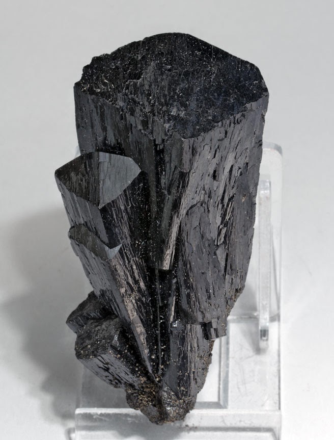
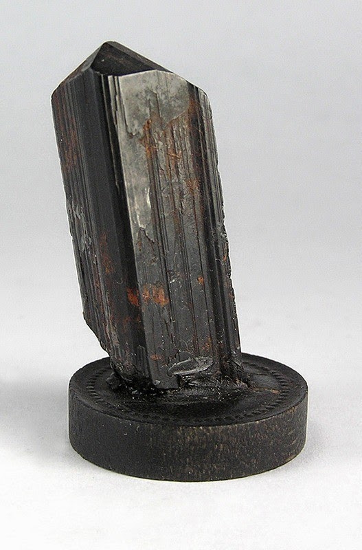
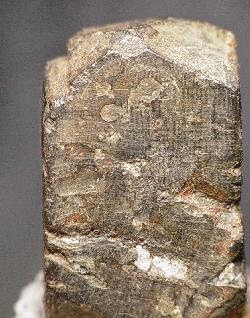
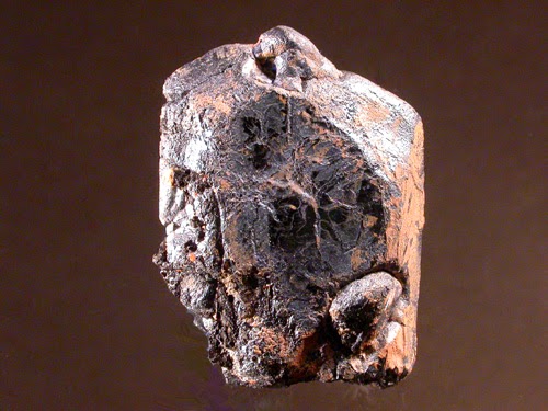
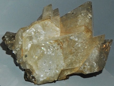
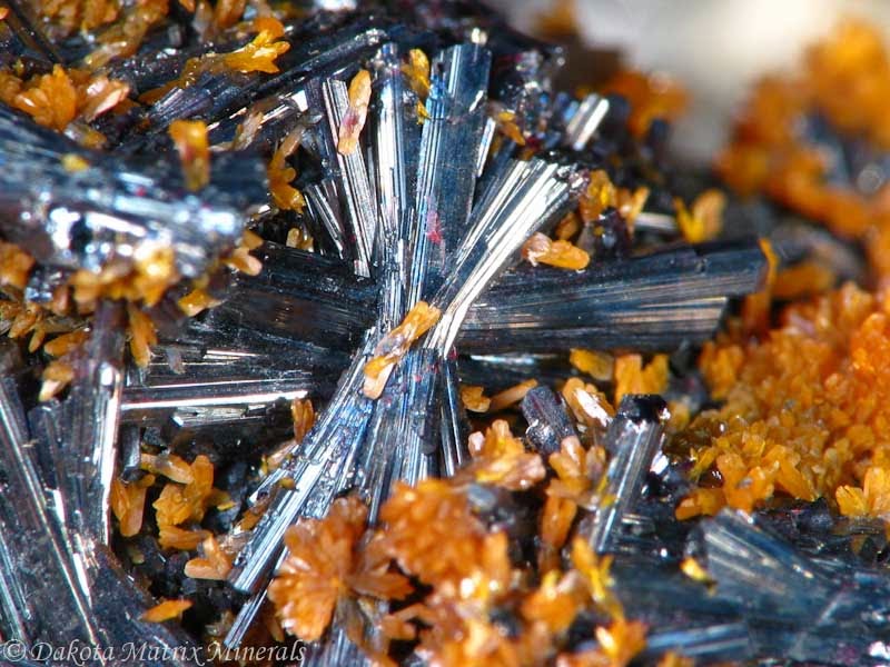
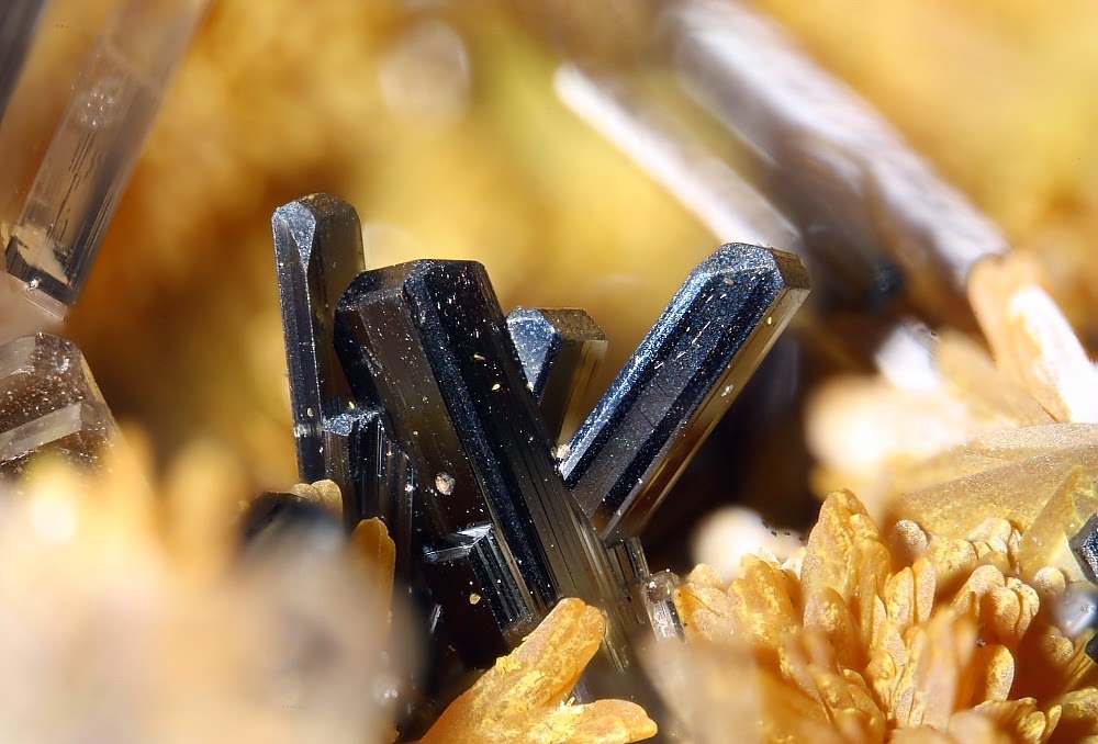
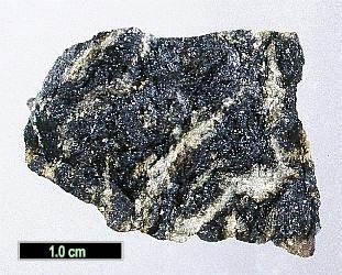
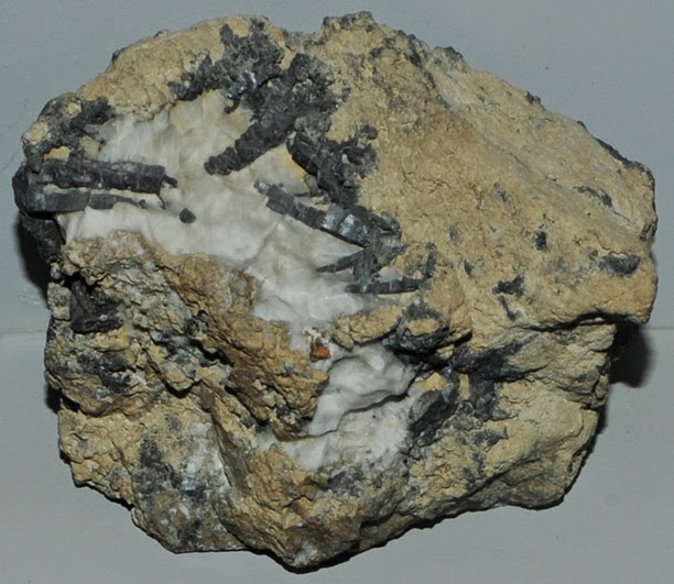
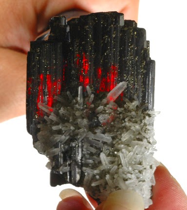
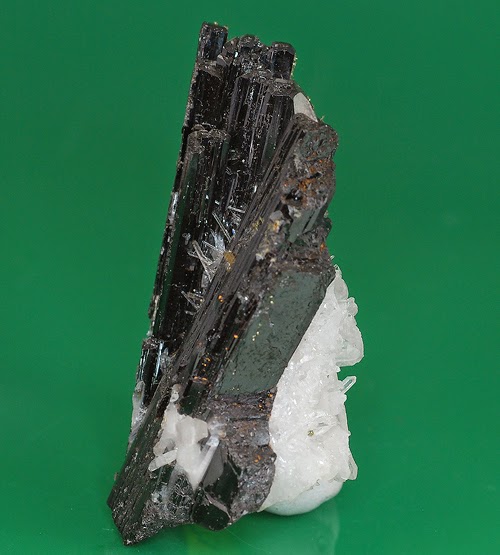
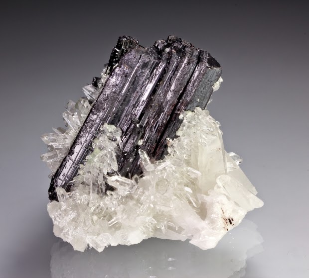
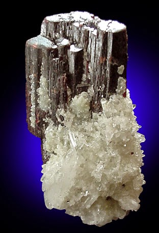
Chemical Formula: CaFe2+2Fe3+(Si2O7)O(OH) Locality: Capo Calamita, on Elba. Name Origin: Named ilvaite from the Latin name of the island of Elba.
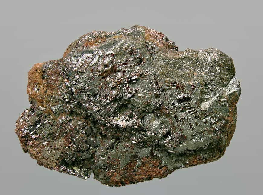
Ilvaite is a sorosilicate of iron and calcium with formula: CaFe2+2Fe3+(Si2O7)O(OH). Both manganese and magnesium substitute in the structure. Ilvaite crystallizes in the orthorhombic system in black prismatic crystals and columnar masses. It is black to brownish black to gray and opaque. It has a Mohs hardness of 5.5 to 6 and a specific gravity of 3.8 to 4.1. Ilvaite is structurally related to lawsonite.
It occurs in contact metamorphic rocks and skarn ore deposits. It also occurs less commonly in syenites.
Ilvaite was first described in 1811 on the island of Elba and the name ilvaite from the Latin name ilva of the island. Sometimes referred to as yenite.
Physical Properties
Cleavage: {010} Distinct, {001} Distinct Color: Iron black, Dark grayish black. Density: 3.99 – 4.05, Average = 4.01 Diaphaneity: Opaque Fracture: Uneven – Flat surfaces (not cleavage) fractured in an uneven pattern. Hardness: 5.5-6 – Knife Blade-Orthoclase Luminescence: Non-fluorescent. Luster: Sub Metallic Streak: brownish black
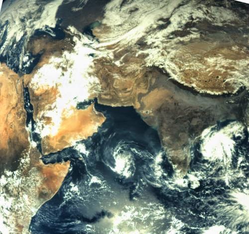
First image taken by the Mars Color Camera aboard India’s Mars Orbiter Mission (MOM) spacecraft while orbiting Earth and before the Trans Mars Insertion firing on Dec. 1, 2013. Image is focused on the Indian subcontinent. Credit: ISRO
While astronomers are trying to figure out which planets they find are habitable, there are a range of things to consider. How close are they to their parent star? What are their atmospheres made of? And once those answers are figured out, here’s something else to wonder about: how many minerals are on the planet’s surface?
In a talk today, the Carnegie Institution of Washington’s Robert Hazen outlined his findings showing that two-thirds of minerals on Earth could have arisen from life itself. The concept is not new—he and his team first published on that in 2008—but his findings came before the plethora of exoplanets discovered by the Kepler space telescope.
As more information is learned about these distant worlds, it will be interesting to see if it’s possible to apply his findings—if we could detect the minerals from afar in the first place.
“We live on a planet of remarkable beauty, and when you look at it from the proximity of our moon, you see what is obviously a very dynamic planet,” Hazen told delegates at “Habitable Worlds Across Time and Space”, a spring symposium from the Space Telescope Science Institute that is being webcast this week (April 28-May 1).
His point was that planets don’t necessarily start out that way, but he said in his talk that he’d invite comments and questions on his work for alternative processes. His team believes that minerals and life co-evolved: life became more complex and the number of minerals increased over time.
The first mineral in the cosmos was likely diamonds, which were formed in supernovas. These star explosions are where the heavier elements in our cosmos were created, making the universe more rich than its initial soup of hydrogen and helium.
There are in fact 10 elements that were key in the Earth’s formation, Hazen said, as well as that of other planets in our solar system (which also means that presumably these would apply to exoplanets). These were carbon, nitrogen, oxygen, magnesium, silicon, carbon, titanium, iron and nitrogen,which formed about a dozen minerals on the early Earth.
Here’s the thing, though. Today there are more than 4,900 minerals on Earth that are formed from 72 essential elements. Quite a change.
Hazen’s group proposes 10 stages of evolution:
Primary chondrite minerals (4.56 billion years ago) – what was around as the solar nebula that formed our solar system cooled. 60 mineral species at this time.
Planetesimals—or protoplanets—changed by impacts (4.56 BYA to 4.55 BYA). Here is where feldspars, micas, clays and quartz arose. 250 mineral species.
Planet formation (4.55 BYA to 3.5 BYA). On a “dry” planet like Mercury, evolution stopped at about 300 mineral species, while “wetter” planets like Mars would have seen about 420 mineral species that includes hydroxides and clays produced from processes such as volcanism and ices.
Granite formation (more than 3.5 BYA). 1,000 mineral species including beryl and tantalite.
Plate tectonics (more than 3 BYA). 1,500 mineral species. Increases produced from changes such as new types of volcanism and high-pressure metamorphic changes inside the Earth.
These stages above are about as far as you would get on a planet without life, Hazen said. As for the remaining stages on Earth, here they are:
Anoxic biosphere (4 to 2.5 BYA), again with about 1,500 mineral species existing in the early atmosphere. Here was the rise of chemolithoautotrophs, or life that obtains energy from oxidizing inorganic compounds.
Paleoproterozoic oxidation (2.5 to 1.5 BYA)—a huge rise in mineral species to 4,500 as oxygen becomes a dominant player in the atmosphere. “We’re trying to understand if this is really true for every other planet, or if there is alternative pathways,” Hazen said.
It should be noted here that oxygen does not necessarily indicate there is complex life. Fellow speaker David Catling from the University of Washington, however, noted that oxygen rose in the atmosphere about 2.4 billion years ago, coincident with the emergence of complex life.
Animals as we understand them could have been “impossible for most of Earth’s history because they couldn’t breathe,” he noted. But more study will be needed on this point. After all, we’ve only found life on one planet: Earth.
Note : The above story is based on materials provided by Universe Today
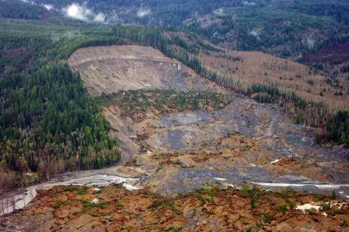
The U.S. Geological Survey captured the upper parts of the landslide in Oso, Wash., in an aerial survey taken five days after this natural disaster killed 41 people. “Active” search and rescue efforts were suspended this week as the community turned its attention to debris removal. Credit: Jonathan Godt, USGS
Mudslides. Landslides. Volcanic debris flows. Avalanches. Falling rocks. They can come along so suddenly that people, homes, roads and even towns are buried or destroyed without much warning. Recently, we’ve had dramatic reminders of this, such as the mudslide in Oso, Wash., where 41 people died; an avalanche on Mt. Everest that killed 13 experienced Sherpas and another landslide event in Jackson, Wyo. And as much as ancient Pompeii serves as the most dramatic, historic reminder of the incredible element of surprise these events can wield, what seems extraordinarily incalculable is becoming…well, calculable.
Maybe that doesn’t seem so surprising on the surface as one reminisces about math story problems of long ago, such as, “if an avalanche flow is moving at a rate of 50 meters per second, how long will it take to swallow up a village located 30 kilometers away?” Unfortunately, for geologists and others involved in these issues, the particulars make the solution far from simple algebra.
Earthen, volcanic and snowy materials—all of which can move quickly downhill—do so at varying rates depending on their composition, the composition of the geological features over which they flow, and the weather. The benefit to building forecasting models—showing how the earthen materials are prone to move and where they might go post-volcano or during a particularly wet spring—is that they can assist policymaking, urban planning, insurance risk assessment and, most importantly, public safety risk reduction.
One National Science Foundation (NSF)-funded mathematician, E. Bruce Pitman from the University of Buffalo, has been modeling the dynamics of flowing granular materials since 2001 when engineering and geology colleagues came together to start estimating volcanic flow.
“You see these wonderful volcanic eruptions with the plumes, but gravity currents are going down the mountain even as all this stuff is going up into the air,” Pitman said. “It can be very deadly. And depending on the mountain—if there’s snow on the mountain—then you have this muddy sort of muck, so it can go even faster downhill.”
Volcanic flows and mudslides are examples of what geoscientists call “gravity currents.”
According to the Centers for Disease Control and Prevention, “landslides and debris flows result in 25 to 50 deaths each year” in the United States. The U.S. Geological Survey (USGS) reports that “all 50 states and the U.S. territories experience landslides and other ground-failure problems,” including 36 states with “moderate to highly severe landslide hazards,” which include the Appalachian and Rocky Mountains, Pacific Coast regions and Puerto Rico.
USGS notes that areas denuded because of wildfires or overdevelopment are particularly vulnerable to the whims of what’s termed generally as “ground failures.”
Pitman has spent the past 13 years studying the flows of the Soufrière Hills volcano on Montserrat, the Colima volcano west of Mexico City and the Ruapehu volcano in New Zealand, among other sites. Working with an engineer whose expertise is in high performance computing, statisticians and several geologists, Pitman studies geophysical mass flows, specifically volcanic avalanches and pyroclastic (hot gas and rock) flows, which are “dry” flows.
“We started modeling volcanic flows as dry volcanic flows, so the equation described the material as each particle frictionally sliding over the next particle,” Pitman said. “However, we knew it wasn’t only solid particles. There could be air or water too, so we developed another model. This naturally makes the analysis harder. In mudslides, you have to factor in mud, which is a viscoplastic fluid—partly like a fluid but also able to deform like a plastic material and never rebound. In wet or dry materials, you can make some reasonable predictions because flow is more or less the same. It is much harder to do that with mud.”
Pitman explained the way a mathematician works to develop a predictive model of a landslide.
“There are three questions,” he said. “First, is something going to happen? That is notoriously difficult—what’s going on under the ground? Where’s the water table? How much moisture is in the soil? What’s the structure of the soil? Since we can’t look under the ground, we have to make all kinds of assumptions about the ground, which poses difficulties.
“Secondly, if a slide were to occur, what areas are at risk? That’s something that with a math model you can hope to explain. OK, is the east, west, north or south slope going to slip? How large a flow? Which areas downstream are at risk?
“Lastly, you have to ask what part of the model do you most care about. This helps you to simplify the modeling. Then you run the what-if scenarios to determine the greatest risk. Is it an area at risk and do mudslides happen regularly?”
According to Michael Steuerwalt, an NSF Division of Mathematical Sciences program director, many would be inclined to think that lava flows are far more complicated to model because of the issues of heat and explosive force. However, a mix of dramatically different particle sizes and shapes—which range from dirt grains to people, cars, houses, boulders and trees—can considerably complicate a slide model.
“If you’re trying to deduce, for example, where under this mudslide is the house that used to be way up there (along with its inhabitants), then the model is very complicated indeed,” Steuerwalt said. “Math won’t solve this problem alone, either. But with topographic data, soil data and predictions of precipitation, one could make assessments of where not to build and estimates of risk. This really is an opportunity for mathematicians coupled not only with statisticians, but also with geographers, geoscientists and engineers.”
Ultimately, the process needs good data. But it is also about understanding where the model has simplified the equation and created “errors.”
“This may sound odd, but it’s not about developing the perfect model,” Pitman said. “All models have errors in them because we make simplifications to wrap our brains around the physical processes at work. The key is quantifying those errors.”
So, essentially the mathematician has to know where to simplify the equation, and that too comes with his collaborative approach and working with other experts, such as volcanologists, and then interfacing with public safety officials.
For a guy who “hated” math in the fifth grade and majored in physics initially in college, this work has turned into something he loves, but also something where he feels he makes a difference.
“I love how this work stretches me and my ability to understand other fields,” he said. “I get to explore what interests them and what just might be the little hook that allows me to pry apart a problem.”
Note : The above story is based on materials provided by National Science Foundation
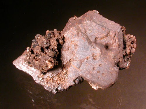
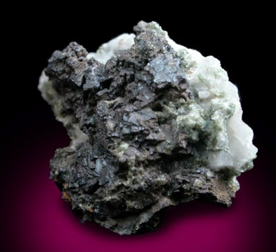
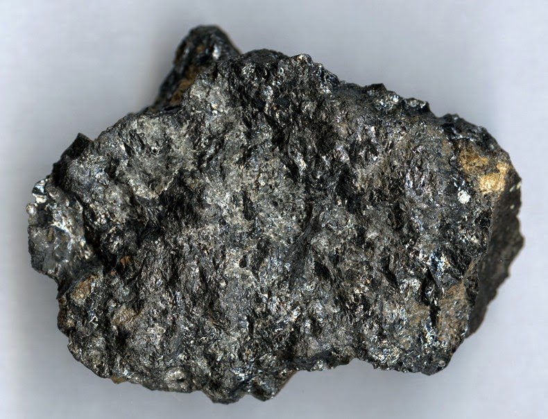
Chemical Formula:FeTiO
3 Locality: Ilmen Mountains, southern Urals, of the Russia. Name Origin: Named after It’s locality.
Ilmenite is the titanium-iron oxide mineral with the idealized formula FeTiO
3. It is a weakly magnetic black or steel-gray solid. From the commercial perspective, ilmenite is the most important ore of titanium.
Structure and properties
Ilmenite crystallizes in the trigonal system. The ilmenite crystal structure consists of an ordered derivative of the corundum structure; in corundum all cations are identical but in ilmenite Fe2+ and Ti4+ ions occupy alternating layers perpendicular to the trigonal c axis. Containing high spin ferrous centers, ilmenite is paramagnetic.
Ilmenite is commonly recognized in altered igneous rocks by the presence of a white alteration product, the pseudo-mineral leucoxene. Often ilmenites are rimmed with leucoxene, which allows ilmenite to be distinguished from magnetite and other iron-titanium oxides. The example shown in the image at right is typical of leucoxene-rimmed ilmenite.
In reflected light it may be distinguished from magnetite by more pronounced reflection pleochroism and a brown-pink tinge.
Samples of ilmenite exhibit a weak response to a hand magnet.
Physical Properties
Cleavage: None Color: Iron black, Black. Density: 4.72 Diaphaneity: Opaque Fracture: Conchoidal – Fractures developed in brittle materials characterized by smoothly curving surfaces, (e.g. quartz). Hardness: 5-5.5 – Apatite-Knife Blade Luminescence: Non-fluorescent. Luster: Sub Metallic Magnetism: Naturally weak Streak: brownish black
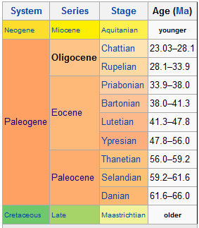
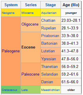
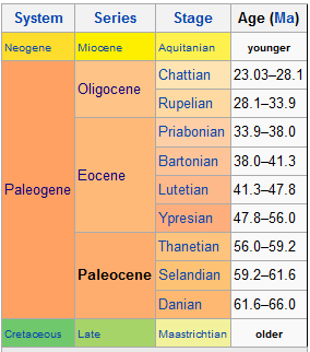
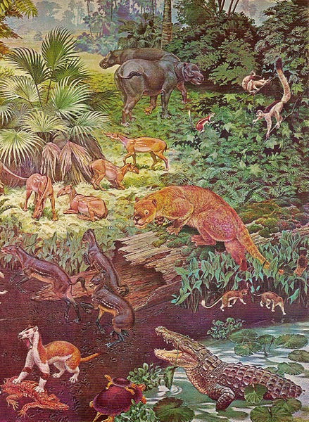
The Oligocene is a geologic epoch of the Paleogene period and extends from about 33.9 million to 23 million years before the present (33.9±0.1 to 23.03±0.05 Ma). As with other older geologic periods, the rock beds that define the period are well identified but the exact dates of the start and end of the period are slightly uncertain. The name Oligocene comes from the Greek ὀλίγος (oligos, few) and καινός (kainos, new), and refers to the sparsity of additional modern mammalian species of fauna after a burst of evolution during the Eocene. The Oligocene is preceded by the Eocene epoch and is followed by the Miocene epoch. The Oligocene is the third and final epoch of the Paleogene period.
The Oligocene is often considered an important time of transition, a link between the archaic world of the tropical Eocene and the more modern ecosystems of the Miocene. Major changes during the Oligocene included a global expansion of grasslands, and a regression of tropical broad leaf forests to the equatorial belt.
The start of the Oligocene is marked by a notable extinction event called the Grande Coupure; it featured the replacement of European fauna with Asian fauna, except for the endemic rodent and marsupial families. By contrast, the Oligocene–Miocene boundary is not set at an easily identified worldwide event but rather at regional boundaries between the warmer late Oligocene and the relatively cooler Miocene.
Subdivisions
Oligocene faunal stages from youngest to oldest are:
Chattian or Late Oligocene (28.1 – 23.03 mya)
Rupelian or Early Oligocene (33.9 – 28.1 mya)
Climate
The Paleogene period general temperature decline is interrupted by an Oligocene 7 million year stepwise climate change. A deeper 8.2 °C, 400,000 year temperature depression leads the 2 °C, 7 million year stepwise climate change 33.5 Ma (Million years ago). The stepwise climate change began 32.5Ma and lasted through to 25.5Ma, as depicted in the PaleoTemps chart. The Oligocene climate change was a global increase in ice volume and a 55 M (181 feet) decrease in sea level (35.7-33.5 Ma) with a closely related (25.5–32.5 Ma) temperature depression. The 7 million year depression abruptly terminated within 1–2 million years of the La Garita Caldera eruption at 28-26 Ma. A deep 400,000 year glaciated Oligocene Miocene boundary event is recorded at McMurdo Sound and King George Island.
This shows estimates of global average surface air temperature over the ~540 My of the Phanerozoic
Paleogeography
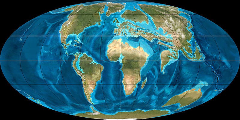
During this period, the continents continued to drift toward their present positions. Antarctica became more isolated and finally developed an ice cap.(Haines)
Mountain building in western North America continued, and the Alps started to rise in Europe as the African plate continued to push north into the Eurasian plate, isolating the remnants of the Tethys Sea. A brief marine incursion marks the early Oligocene in Europe. Marine fossils from the Oligocene are rare in North America. There appears to have been a land bridge in the early Oligocene between North America and Europe, since the faunas of the two regions are very similar. Sometime during the Oligocene, South America was finally detached from Antarctica and drifted north towards North America. It also allowed the Antarctic Circumpolar Current to flow, rapidly cooling the Antarctic continent.
Flora
Angiosperms continued their expansion throughout the world as tropical and sub-tropical forests were replaced by temperate deciduous forests. Open plains and deserts became more common and grasses expanded from their water-bank habitat in the Eocene moving out into open tracts. However, even at the end of the period grass was not quite common enough for modern savannas.(Haines)
In North America, subtropical species dominated with cashews and lychee trees present, and temperate trees such as roses, beeches, and pines were common. The legumes spread, while sedges, bulrushes, and ferns continued their ascent.
Fauna
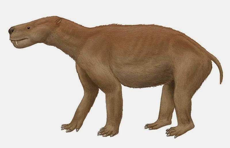
Important Oligocene land fauna are found on all continents at this time. Even more open landscapes allowed animals to grow to larger sizes than they had earlier in the Paleogene. Marine faunas became fairly modern, as did terrestrial vertebrate fauna on the northern continents. This was probably more as a result of older forms dying out than as a result of more modern forms evolving. Many groups, such as horses, entelodonts, rhinoceroses, oreodonts, and camels, became more able to run during this time, adapting to the plains that were spreading as the Eocene rainforests receded. The first felid, Proailurus, originated in Asia during the late Oligocene and spread to Europe.
South America was isolated from the other continents and evolved a quite distinct fauna during the Oligocene. The South American continent became home to strange animals such as pyrotheres and astrapotheres, as well as litopterns and notoungulates. Sebecosuchian crocodiles, terror birds, and carnivorous marsupials, like the borhyaenids remained the dominant predators. Brontotheres died out in the Earliest Oligocene, and creodonts died out outside Africa and the Middle East at the end of the period. Multituberculates, an ancient lineage of primitive mammals, also went extinct in the Oligocene. The Oligocene was home to a wide variety of strange mammals. A good example of this would be in the White River Badlands of North America, which were formerly a semi-arid prairie home to many different types of endemic mammals, including entelodonts like Archaeotherium, camels (such as Poebrotherium), running rhinos, three-toed horses (such as Mesohippus), nimravids, protoceratids, and early dogs like Hesperocyon. Oreodonts, an endemic American group, were very diverse during this time. In Asia during the Oligocene, a group of running rhinos gave rise to the indricotheres, like Indricotherium, which were the largest land mammals ever to walk the Earth.
The marine animals of Oligocene oceans resembled today’s fauna, such as the bivalves. Calcareous cirratulids appeared in the Oligocene. The fossil record of marine mammals is a little spotty during this time, and not as well known as the Eocene or Miocene, but some fossils have been found. The baleen and toothed cetaceans, or whales, had just appeared, and their ancestors, the archaeocete cetaceans began to decrease in diversity due to their lack of echolocation, which was very useful as the water became colder and cloudier. Other factors to their decline could include climate changes and competition with today’s modern cetaceans and the carcharhinid sharks, which also appeared in this epoch. Early desmostylians, like Behemotops, are known from the Oligocene. Pinnipeds probably appeared near the end of the epoch from a bear-like or otter-like ancestor.
Oceans
The Oligocene sees the beginnings of modern ocean circulation, with tectonic shifts causing the opening and closing of ocean gateways. Cooling of the oceans had already commenced by the Eocene/Oligocene boundary, and they continued to cool as the Oligocene progressed. The formation of permanent Antarctic ice sheets during the early Oligocene and possible glacial activity in the Arctic may have influenced this oceanic cooling, though the extent of this influence is still a matter of some significant dispute.
The effects of oceanic gateways on circulation
The opening and closing of ocean gateways: the opening of the Drake Passage; the opening of the Tasmanian Gateway and the closing of the Tethys seaway; along with the final formation of the Greenland–Iceland–Faroes sill; played vital parts in reshaping oceanic currents during the Oligocene. As the continents shifted to a more modern configuration, so too did ocean circulation.
The Drake Passage
The Drake Passage is located between South America and Antarctica. Once the Tasmanian Gateway between Australia and Antarctica opened, all that kept Antarctica from being completely isolated by the Southern Ocean was its connection to South America. As the South American continent moved north, the Drake Passage opened and enabled the formation of the Antarctic Circumpolar Current (ACC), which would have kept the cold waters of Antarctica circulating around that continent and strengthened the formation of Antarctic Bottom Water (ABW). With the cold water concentrated around Antarctica, sea surface temperatures and, consequently, continental temperatures would have dropped. The onset of Antarctic glaciation occurred during the early Oligocene, and the effect of the Drake Passage opening on this glaciation has been the subject of much research. However, some controversy still exists as to the exact timing of the passage opening, whether it occurred at the start of the Oligocene or nearer the end. Even so, many theories agree that at the Eocene/Oligocene (E/O) boundary, a yet shallow flow existed between South America and Antarctica, permitting the start of an Antarctic Circumpolar Current.
Stemming from the issue of when the opening of the Drake Passage took place, is the dispute over how great of an influence the opening of the Drake Passage had on the global climate. While early researchers concluded that the advent of the ACC was highly important, perhaps even the trigger, for Antarctic glaciation and subsequent global cooling, other studies have suggested that the δ18O signature is too strong for glaciation to be the main trigger for cooling. Through study of Pacific ocean sediments, other researchers have shown that the transition from warm Eocene ocean temperatures to cool Oligocene ocean temperatures took only 300,000 years, which strongly implies that feedbacks and factors other than the ACC were integral to the rapid cooling.
The Late Oligocene opening of the Drake Passage
The latest hypothesized time for the opening of the Drake Passage is during the early Miocene. Despite the shallow flow between South America and Antarctica, there was not enough of a deep water opening to allow for significant flow to create a true Antarctic Circumpolar Current. If the opening occurred as late as hypothesized, then the Antarctic Circumpolar Current could not have had much of an effect on early Oligocene cooling, as it would not have existed.
The Early Oligocene opening of the Drake Passage
The earliest hypothesized time for the opening of the Drake Passage is around 30 Ma. One of the possible issues with this timing was the continental debris cluttering up the seaway between the two plates in question. This debris, along with what is known as the Shackleton Fracture Zone, has been shown in a recent study to be fairly young, only about 8 million years old. The study concludes that the Drake Passage would be free to allow significant deep water flow by around 31 Ma. This would have facilitated an earlier onset of the Antarctic Circumpolar Current.
Currently, an opening of the Drake Passage during the Early Oligocene is favored.
The opening of the Tasman Gateway
The other major oceanic gateway opening during this time was the Tasman, or Tasmanian, depending on the paper, gateway between Australia and Antarctica. The time frame for this opening is less disputed than the Drake Passage and is largely considered to have occurred around 34 Ma. As the gateway widened, the Antarctic Circumpolar Current strengthened.
The Tethys Seaway closing
Though the Tethys was not a gateway, but rather a sea in its own right. Its closing during the Oligocene had significant impact on both ocean circulation and climate. The collisions of the African plate with the European plate and of the Indian subcontinent with the Asian plate, cut off the Tethys seaway that had provided a low-latitude ocean circulation. The closure of Tethys built some new mountains (the Zagros range) and drew down more carbon dioxide from the atmosphere, contributing to global cooling.
Greenland–Iceland–Faroes
The gradual separation of the clump of continental crust and the deepening of tectonic sill in the North Atlantic that would become Greenland, Iceland, and the Faroe Islands helped to increase the deep water flow in that area. More information about the evolution of North Atlantic Deep Water will be given a few sections down.
Ocean cooling
Evidence for ocean-wide cooling during the Oligocene exists mostly in isotopic proxies. Patterns of extinction and patterns of species migration can also be studied to gain insight into ocean conditions. For a while, it was thought that the glaciation of Antarctica may have significantly contributed to the cooling of the ocean, however, recent evidence tends to deny this.
Deep water
Isotopic evidence suggests that during the early Oligocene, the main source of deep water was the North Pacific and the Southern Ocean. As the Greenland-Iceland-Faroe sill deepened and thereby connected the Norwegian–Greenland sea with the Atlantic Ocean, the deep water of the North Atlantic began to come into play as well. Computer models suggest that once this occurred, a more modern in appearance thermo-haline circulation started.
North Atlantic deep water
Evidence for the early Oligocene onset of chilled North Atlantic deep water lies in the beginnings of sediment drift deposition in the North Atlantic, such as the Feni and Southeast Faroe drifts
South Ocean deep water
The chilling of the South Ocean deep water began in earnest once the Tasmanian Gateway and the Drake Passage opened fully. Regardless of the time at which the opening of the Drake Passage occurred, the effect on the cooling of the Southern Ocean would have been the same.
Impact events
Recorded extraterrestrial impacts:
Nunavut, Canada (23 Ma, crater 24 km (15 mi) diameter,)
Supervolcanic explosions
La Garita Caldera (28 through 26 million years ago, VEI=9.2)The above story is based on materials provided by Wikipedia
The Eocene epoch, lasting from 56 to 33.9 million years ago, is a major division of the geologic timescale and the second epoch of the Paleogene Period in the Cenozoic Era. The Eocene spans the time from the end of the Palaeocene Epoch to the beginning of the Oligocene Epoch. The start of the Eocene is marked by a brief period in which the concentration of the carbon isotope 13C in the atmosphere was exceptionally low in comparison with the more common isotope 12C. The end is set at a major extinction event called the Grande Coupure (the “Great Break” in continuity) or the Eocene–Oligocene extinction event, which may be related to the impact of one or more large bolides in Siberia and in what is now Chesapeake Bay. As with other geologic periods, the strata that define the start and end of the epoch are well identified, though their exact dates are slightly uncertain.
The name Eocene comes from the Greek ἠώς (eos, dawn) and καινός (kainos, new) and refers to the “dawn” of modern (‘new’) fauna that appeared during the epoch.
Subdivisions
The Eocene epoch is usually broken into Early and Late, or—more usually—Early, Middle, and Late subdivisions. The corresponding rocks are referred to as Lower, Middle, and Upper Eocene. Of the stages shown above, the Ypresian and occasionally the Lutetian constitute the Early, the Priabonian and sometimes the Bartonian the Late state; alternatively, the Lutetian and Bartonian are united as the Middle Eocene.
Climate
The Eocene Epoch contained a wide variety of different climate conditions that includes the warmest climate in the Cenozoic Era and ends in an icehouse climate. The evolution of the Eocene climate began with warming after the end of the Palaeocene-Eocene Thermal Maximum (PETM) at 56 million years ago to a maximum during the Eocene Optimum at around 49 million years ago. During this period of time, little to no ice was present on Earth with a smaller difference in temperature from the equator to the poles. Following the maximum was a descent into an icehouse climate from the Eocene Optimum to the Eocene-Oligocene transition at 34 million years ago. During this decrease ice began to reappear at the poles, and the Eocene-Oligocene transition is the period of time where the Antarctic ice sheet began to rapidly expand.
Atmospheric greenhouse gas evolution
Greenhouse gases, in particular carbon dioxide and methane, played a significant role during the Eocene in controlling the surface temperature. The end of the PETM was met with a very large sequestration of carbon dioxide in the form of methane clathrate, coal, and crude oil at the bottom of the Arctic Ocean, that reduced the atmospheric carbon dioxide. This event was similar in magnitude to the massive release of greenhouse gasses at the beginning of the PETM, and it is hypothesized that the sequestration was mainly due to organic carbon burial and weathering of silicates. For the early Eocene there is much discussion on how much carbon dioxide is in the atmosphere. This is due to numerous proxies representing different atmospheric carbon dioxide content. For example, diverse geochemical and paleontological proxies indicate that at the maximum of global warmth the atmospheric carbon dioxide values were at 700 – 900 ppm while other proxies such as pedogenic (soil building) carbonate and marine boron isotopes indicate large changes of carbon dioxide of over 2,000 ppm over periods of time of less than 1 million years. Sources for this large influx of carbon dioxide could be attributed to volcanic out-gassing due to North Atlantic rifting or oxidation of methane stored in large reservoirs deposited from the PETM event in the sea floor or wetland environments. For contrast, today the carbon dioxide levels are at 400 ppm or .04%.
During the early Eocene, methane was another greenhouse gas that had a drastic effect on the climate. In comparison to carbon dioxide, methane has much higher consequences with regards to temperature as methane has ~23 times more effect per molecule than carbon dioxide on a 100-year scale (it has a higher global warming potential). The majority of the methane released to the atmosphere during this period of time would have been from wetlands, swamps, and forests. The atmospheric methane concentration today is 0.000179% or 1.79 ppmv. Due to the warmer climate and sea level rise associated with the early Eocene, more wetlands, more forests, and more coal deposits would be available for methane release. Comparing the early Eocene production of methane to current levels of atmospheric methane, the early Eocene would be able to produce triple the amount of current methane production. The warm temperatures during the early Eocene could have increased methane production rates, and methane that is released into the atmosphere would in turn warm the troposphere, cool the stratosphere, and produce water vapor and carbon dioxide through oxidation. Biogenic production of methane produces carbon dioxide and water vapor along with the methane, as well as yielding infrared radiation. The breakdown of methane in an oxygen atmosphere produces carbon monoxide, water vapor and infrared radiation. The carbon monoxide is not stable so it eventually becomes carbon dioxide and in doing so releases yet more infrared radiation. Water vapor, traps more infrared than does carbon dioxide.
The middle to late Eocene marks not only the switch from warming to cooling, but also the change in carbon dioxide from increasing to decreasing. At the end of the Eocene Optimum, carbon dioxide began decreasing due to increased siliceous plankton productivity and marine carbon burial. At the beginning of the middle Eocene an event that may have triggered or helped with the draw down of carbon dioxide was the Azolla event at around 49 million years ago. With the equable climate during the early Eocene, warm temperatures in the arctic allowed for the growth of azolla, which is a floating aquatic fern, on the Arctic Ocean. Compared to current carbon dioxide levels, these azolla grew rapidly in the enhanced carbon dioxide levels found in the early Eocene. As these azolla sank into the Arctic Ocean, they became buried and sequestered their carbon into the seabed. This event could have led to a draw down of atmospheric carbon dioxide of up to 470 ppm. Assuming the carbon dioxide concentrations were at 900 ppmv prior to the Azolla Event they would have dropped to 430 ppmv, or 40 ppmv more than they are today, after the Azolla Event. Another event during the middle Eocene that was a sudden and temporary reversal of the cooling conditions was the Middle Eocene Climatic Optimum. At around 41.5 million years ago, stable isotopic analysis of samples from Southern Ocean drilling sites indicated a warming event for 600 thousand years. A sharp increase in atmospheric carbon dioxide was observed with a maximum of 4000 ppm: the highest amount of atmospheric carbon dioxide detected during the Eocene. The main hypothesis for such a radical transition was due to the continental drift and collision of the India continent with the Asia continent and the resulting formation of the Himalayas. Another hypothesis involves extensive sea floor rifting and metamorphic decarbonation reactions releasing considerable amounts of carbon dioxide to the atmosphere.
At the end of the Middle Eocene Climatic Optimum, cooling and the carbon dioxide drawdown continued through the late Eocene and into the Eocene-Oligocene transition around 34 million years ago. Multiple proxies, such as oxygen isotopes and alkenones, indicate that at the Eocene-Oligocene transition, the atmospheric carbon dioxide concentration had decreased to around 750-800 ppm, approximately twice that of present levels.
Early Eocene and the equable climate problem
One of the unique features of the Eocene’s climate as mentioned before was the equable and homogeneous climate that existed in the early parts of the Eocene. A multitude of proxies support the presence of a warmer equable climate being present during this period of time. A few of these proxies include the presence of fossils native to warm climates, such as crocodiles, located in the higher latitudes, the presence in the high-latitudes of frost-intolerant flora such as palm trees which cannot survive during sustained freezes, and fossils of snakes found in the tropics that would require much higher average temperatures to sustain them. Using isotope proxies to determine ocean temperatures indicate sea surface temperatures in the tropics as high as 35 °C (95 °F) and bottom water temperatures that are 10 °C (18 °F) higher than present day values. With these bottom water temperatures, temperatures in areas where deep-water forms near the poles are unable to be much cooler than the bottom water temperatures.
An issue arises, however, when trying to model the Eocene and reproduce the results that are found with the proxy data. Using all different ranges of greenhouse gasses that occurred during the early Eocene, models were unable to produce the warming that was found at the poles and the reduced seasonality that occurs with winters at the poles being substantially warmer. The models, while accurately predicting the tropics, tend to produce significantly cooler temperatures of up to 20 °C (36 °F) underneath the actual determined temperature at the poles. This error has been classified as the “equable climate problem”. To solve this problem, the solution would involve finding a process to warm the poles without warming the tropics. Some hypotheses and tests which attempt to find the process are listed below.
Large lakes
Due to the nature of water as opposed to land, less temperature variability would be present if a large body of water is also present. In an attempt to try to mitigate the cooling polar temperatures, large lakes were proposed to mitigate seasonal climate changes. To replicate this case, a lake was inserted into North America and a climate model was run using varying carbon dioxide levels. The model runs concluded that while the lake did reduce the seasonality of the region greater than just an increase in carbon dioxide, the addition of a large lake was unable to reduce the seasonality to the levels shown by the floral and faunal data.
Ocean heat transport
The transport of heat from the tropics to the poles, much like how ocean heat transport functions in modern times, was considered a possibility for the increased temperature and reduced seasonality for the poles. With the increased sea surface temperatures and the increased temperature of the deep ocean water during the early Eocene, one common hypothesis was that due to these increases there would be a greater transport of heat from the tropics to the poles. Simulating these differences, the models produced lower heat transport due to the lower temperature gradients and were unsuccessful in producing an equable climate from only ocean heat transport.
Orbital parameters
While typically seen as a control on ice growth and seasonality, the orbital parameters were theorized as a possible control on continental temperatures and seasonality. Simulating the Eocene by using an ice free planet, eccentricity, obliquity, and precession were modified in different model runs to determine all the possible different scenarios that could occur and their effects on temperature. One particular case led to warmer winters and cooler summer by up to 30% in the North American continent, and it reduced the seasonal variation of temperature by up to 75%. While orbital parameters did not produce the warming at the poles, the parameters did show a great effect on seasonality and needed to be considered.
Polar stratospheric clouds
Another method considered for producing the warm polar temperatures were polar stratospheric clouds. Polar stratospheric clouds are clouds that occur in the lower stratosphere at very low temperatures. Polar stratospheric clouds have a great impact on radiative forcing. Due to their minimal albedo properties and their optical thickness, polar stratospheric clouds act similar to a greenhouse gas and traps outgoing longwave radiation. Different types of polar stratospheric clouds occur in the atmosphere: polar stratospheric clouds that are created due to interactions with nitric or sulfuric acid and water (Type I) or polar stratospheric clouds that are created with only water ice (Type II).
Methane is an important factor in the creation of the primary Type II polar stratospheric clouds that were created in the early Eocene. Since water vapor is the only supporting substance used in Type II polar stratospheric clouds, the presence of water vapor in the lower stratosphere is necessary where in most situations the presence of water vapor in the lower stratosphere is rare. When methane is oxidized, a significant amount of water vapor is released. Another requirement for polar stratospheric clouds is cold temperatures to ensure condensation and cloud production. Polar stratospheric cloud production, since it requires the cold temperatures, is usually limited to nighttime and winter conditions. With this combination of wetter and colder conditions in the lower stratosphere, polar stratospheric clouds could have formed over wide areas in Polar Regions.
To test the polar stratospheric clouds effects on the Eocene climate, models were run comparing the effects of polar stratospheric clouds at the poles to an increase in atmospheric carbon dioxide.The polar stratospheric clouds had a warming effect on the poles, increasing temperatures by up to 20 °C in the winter months. A multitude of feedbacks also occurred in the models due to the polar stratospheric clouds’ presence. Any ice growth was slowed immensely and would lead to any present ice melting. Only the poles were affected with the change in temperature and the tropics were unaffected, which with an increase in atmospheric carbon dioxide would also cause the tropics to increase in temperature. Due to the warming of the troposphere from the increased greenhouse effect of the polar stratospheric clouds, the stratosphere would cool and would potentially increase the amount of polar stratospheric clouds.
While the polar stratospheric clouds could explain the reduction of the equator to pole temperature gradient and the increased temperatures at the poles during the early Eocene, there are a few drawbacks to maintaining polar stratospheric clouds for an extended period of time. Separate model runs were used to determine the sustainability of the polar stratospheric clouds. Methane would need to be continually released and sustained to maintain the lower stratospheric water vapor. Increasing amounts of ice and condensation nuclei would be need to be high for the polar stratospheric cloud to sustain itself and eventually expand.
Hyperthermals through the Early Eocene
During the warming in the Early Eocene between 52 and 55 million years ago, there were a series of short-term changes of carbon isotope composition in the ocean. These isotope changes occurred due to the release of carbon from the ocean into the atmosphere that led to a temperature increase of 4-8 °C (7.2-14.4 °F) at the surface of the ocean. These hyperthermals led to increased perturbations in planktonic and benthic foraminifera, with a higher rate of sedimentation as a consequence of the warmer temperatures. Recent analysis of and research into these hyperthermals in the early Eocene has led to hypotheses that the hyperthermals are based on orbital parameters, in particular eccentricity and obliquity. The hyperthermals in the early Eocene, notably the Palaeocene-Eocene Thermal Maximum (PETM), the Eocene Thermal Maximum 2 (ETM2), and the Eocene Thermal Maximum 3 (ETM3), were analyzed and found that orbital control may have had a role in triggering the ETM2 and ETM3.
Greenhouse to icehouse climate
The Eocene is not only known for containing the warmest period during the Cenozoic, but it also marked the decline into an icehouse climate and the rapid expansion of the Antarctic ice sheet. The transition from a warming climate into a cooling climate began at ~49 million years ago. Isotopes of carbon and oxygen indicate a shift to a global cooling climate. The cause of the cooling has been attributed to a significant decrease of >2000 ppm in atmospheric carbon dioxide concentrations. One proposed cause of the reduction in carbon dioxide during the warming to cooling transition was the Azolla event. The increased warmth at the poles, the isolated Arctic basin during the early Eocene, and the significantly high amounts of carbon dioxide possibly led to azolla blooms across the Arctic Ocean. The isolation of the Arctic Ocean led to stagnant waters and as the azolla sank to the sea floor, they became part of the sediments and effectively sequestered the carbon. The ability for the azolla to sequester carbon is exceptional, and the enhanced burial of azolla could have had a significant effect on the world atmospheric carbon content and may have been the event to begin the transition into an ice house climate. Cooling after this event continued due to continual decrease in atmospheric carbon dioxide from organic productivity and weathering from mountain building.
Global cooling continued until there was a major reversal from cooling to warming indicated in the Southern Ocean at around 42-41 million years ago. Oxygen isotope analysis showed a large negative change in the proportion of heavier oxygen isotopes to lighter oxygen isotopes, which indicates an increase in global temperatures. This warming event is known as the Middle Eocene Climatic Optimum. The cause of the warming is considered to primarily be due to carbon dioxide increases, since carbon isotope signatures rule out major methane release during this short term warming. The increase in atmospheric carbon dioxide is considered to be due to increased seafloor spreading rates between Australia and Antarctica and increased amounts of volcanism in the region. Another possible atmospheric carbon dioxide increase could be during a sudden increase with metamorphic release during the Himalayan orogeny, however data on the exact timing of metamorphic release of atmospheric carbon dioxide is not well resolved in the data. Recent studies have mentioned, however, that the removal of the ocean between Asia and India could release significant amounts of carbon dioxide.This warming is short lived, as benthic oxygen isotope records indicate a return to cooling at ~40 million years ago.
Cooling continued throughout the rest of the Late Eocene into the Eocene-Oligocene transition. During the cooling period, benthic oxygen isotopes show the possibility of ice creation and ice increase during this later cooling. The end of the Eocene and beginning of the Oligocene is marked with the massive expansion of area of the Antarctic ice sheet that was a major step into the icehouse climate. Along with the decrease of atmospheric carbon dioxide reducing the global temperature, orbital factors in ice creation can be seen with 100,000 year and 400,000 year fluctuations in benthic oxygen isotope records. Another major contribution to the expansion of the ice sheet was the creation of the Antarctic circumpolar current. The creation of the Antarctic circumpolar current would isolate the cold water around the Antarctic, which would reduce heat transport to the Antarctic along with create ocean gyres that result in the upwelling of colder bottom waters. The issue with this hypothesis of the consideration of this being a factor for the Eocene-Oligocene transition is the timing of the creation of the circulation is uncertain. For Drake Passage, sediments indicate the opening occurred ~41 million years ago while tectonics indicate that this occurred ~32 million years ago.
Palaeogeography
During the Eocene, the continents continued to drift toward their present positions.
At the beginning of the period, Australia and Antarctica remained connected, and warm equatorial currents mixed with colder Antarctic waters, distributing the heat around the planet and keeping global temperatures high, but when Australia split from the southern continent around 45 Ma, the warm equatorial currents were routed away from Antarctica. An isolated cold water channel developed between the two continents. The Antarctic region cooled down, and the ocean surrounding Antarctica began to freeze, sending cold water and icefloes north, reinforcing the cooling.
The northern supercontinent of Laurasia began to break up, as Europe, Greenland and North America drifted apart.
In western North America, mountain building started in the Eocene, and huge lakes formed in the high flat basins among uplifts, resulting in the deposition of the Green River Formation lagerstätte.
At about 35 Ma, an asteroid impact on the eastern coast of North America formed the Chesapeake Bay impact crater.
In Europe, the Tethys Sea finally vanished, while the uplift of the Alps isolated its final remnant, the Mediterranean, and created another shallow sea with island archipelagos to the north. Though the North Atlantic was opening, a land connection appears to have remained between North America and Europe since the faunas of the two regions are very similar.
India continued its journey away from Africa and began its collision with Asia, folding the Himalayas into existence.
It is hypothesized that the Eocene hothouse world was caused by runaway global warming from released methane clathrates deep in the oceans. The clathrates were buried beneath mud that was disturbed as the oceans warmed. Methane (CH4) has ten to twenty times the greenhouse gas effect of carbon dioxide (CO2).
Flora
At the beginning of the Eocene, the high temperatures and warm oceans created a moist, balmy environment, with forests spreading throughout the Earth from pole to pole. Apart from the driest deserts, Earth must have been entirely covered in forests.
Polar forests were quite extensive. Fossils and even preserved remains of trees such as swamp cypress and dawn redwood from the Eocene have been found on Ellesmere Island in the Arctic. Even at that time, Ellesmere Island was only a few degrees in latitude further south than it is today. Fossils of subtropical and even tropical trees and plants from the Eocene have also been found in Greenland and Alaska. Tropical rainforests grew as far north as northern North America and Europe.
Palm trees were growing as far north as Alaska and northern Europe during the early Eocene, although they became less abundant as the climate cooled. Dawn redwoods were far more extensive as well.
Cooling began mid-period, and by the end of the Eocene continental interiors had begun to dry out, with forests thinning out considerably in some areas. The newly evolved grasses were still confined to river banks and lake shores, and had not yet expanded into plains and savannas.
The cooling also brought seasonal changes. Deciduous trees, better able to cope with large temperature changes, began to overtake evergreen tropical species. By the end of the period, deciduous forests covered large parts of the northern continents, including North America, Eurasia and the Arctic, and rainforests held on only in equatorial South America, Africa, India and Australia.
Antarctica, which began the Eocene fringed with a warm temperate to sub-tropical rainforest, became much colder as the period progressed; the heat-loving tropical flora was wiped out, and by the beginning of the Oligocene, the continent hosted deciduous forests and vast stretches of tundra.
The oldest known fossils of most of the modern mammal orders appear within a brief period during the early Eocene. At the beginning of the Eocene, several new mammal groups arrived in North America. These modern mammals, like artiodactyls, perissodactyls and primates, had features like long, thin legs, feet and hands capable of grasping, as well as differentiated teeth adapted for chewing. Dwarf forms reigned. All the members of the new mammal orders were small, under 10 kg; based on comparisons of tooth size, Eocene mammals were only 60% of the size of the primitive Palaeocene mammals that preceded them. They were also smaller than the mammals that followed them. It is assumed that the hot Eocene temperatures favored smaller animals that were better able to manage the heat.
Both groups of modern ungulates (hoofed animals) became prevalent because of a major radiation between Europe and North America, along with carnivorous ungulates like Mesonyx. Early forms of many other modern mammalian orders appeared, including bats, proboscidians (elephants), primates, rodents and marsupials. Older primitive forms of mammals declined in variety and importance. Important Eocene land fauna fossil remains have been found in western North America, Europe, Patagonia, Egypt and southeast Asia. Marine fauna are best known from South Asia and the southeast United States.
Reptile fossils from this time, such as fossils of pythons and turtles, are abundant. The remains of Titanoboa, a snake the length of a school bus, was discovered in South America along with other large reptilian megafauna. During the Eocene, plants and marine faunas became quite modern. Many modern bird orders first appeared in the Eocene.
Several rich fossil insect faunas are known from the Eocene, notably the Baltic amber found mainly along the south coast of the Baltic Sea, amber from the Paris Basin, France, the Fur Formation, Denmark and the Bembridge Marls from the Isle of Wight, England. Insects found in Eocene deposits are mostly assignable to modern genera, though frequently these genera do not occur in the area at present. For instance the bibionid genus Plecia is common in fossil faunas from presently temperate areas, but only lives in the tropics and subtropics today.
Oceans
The Eocene oceans were warm and teeming with fish and other sea life. The first carcharinid sharks evolved, as did early marine mammals, including Basilosaurus, an early species of whale that is thought to be descended from land animals that existed earlier in the Eocene, the hoofed predators called mesonychids, of which Mesonyx was a member. The first sirenians, relatives of the elephants, also evolved at this time.
Eocene–Oligocene extinction
The end of the Eocene was marked by the Eocene–Oligocene extinction event, also known as the Grande Coupure.
The above story is based on materials provided by Wikipedia
The Paleocene or Palaeocene, the “old recent”, is a geologic epoch that lasted from about 66 to 56 million years ago. It is the first epoch of the Palaeogene Period in the modern Cenozoic Era. As with many geologic periods, the strata that define the epoch’s beginning and end are well identified, but the exact ages remain uncertain.
The Paleocene Epoch brackets two major events in Earth’s history. It started with the mass extinction event at the end of the Cretaceous, known as the Cretaceous-Paleogene (K-Pg) boundary. This was a time marked by the demise of non-avian dinosaurs, giant marine reptiles and much other fauna and flora. The die-off of the dinosaurs left unfilled ecological niches worldwide. It ended with the Paleocene-Eocene Thermal Maximum. This was a geologically brief (~0.2 million year) interval characterized by extreme changes in climate and carbon cycling.
The name “Paleocene” comes from Greek and refers to the “old(er)” (παλαιός, palaios) “new” (καινός, kainos) fauna that arose during the epoch.
Boundaries and subdivisions
The K–Pg boundary that marks the separation between Cretaceous and Paleocene is visible in the geological record of much of the Earth by a discontinuity in the fossil fauna, with high iridium levels. There is also fossil evidence of abrupt changes in flora and fauna. There is some evidence that a substantial but very short-lived climatic change may have happened in the very early decades of the Paleocene. There are several theories about the cause of the K-Pg extinction event, with most evidence supporting the impact of a 10 km diameter asteroid forming the buried Chicxulub crater on the coast of Yucatan, Mexico.
The end of the Paleocene (~55.8 Ma) was also marked by a time of major change. one of the most significant periods of global change during the Cenozoic. The Paleocene-Eocene Thermal Maximum upset oceanic and atmospheric circulation and led to the extinction of numerous deep-sea benthic foraminifera and a major turnover in mammals on land.
The Paleocene is divided into three stages, the Danian, the Selandian and the Thanetian, as shown in the table above. Additionally, the Paleocene is divided into six Mammal Paleogene zones.
Climate
The early Paleocene was cooler and dryer than the preceding Cretaceous, though temperatures rose sharply during the Paleocene–Eocene Thermal Maximum. The climate became warm and humid worldwide towards the Eocene boundary, with subtropical vegetation growing in Greenland and Patagonia, crocodiles swimming off the coast of Greenland, and early primates evolving in tropical palm forests of northern Wyoming. The Earth’s poles were cool and temperate; North America, Europe, Australia and southern South America were warm and temperate; equatorial areas had tropical climates; and north and south of the equatorial areas, climates were hot and arid.
Paleogeography
In many ways, the Paleocene continued processes that had begun during the late Cretaceous Period. During the Paleocene, the continents continued to drift toward their present positions. Supercontinent Laurasia had not yet separated into three continents – Europe and Greenland were still connected, North America and Asia were still intermittently joined by a land bridge, while Greenland and North America were beginning to separate. The Laramide orogeny of the late Cretaceous continued to uplift the Rocky Mountains in the American west, which ended in the succeeding epoch.
South and North America remained separated by equatorial seas (they joined during the Neogene); the components of the former southern supercontinent Gondwanaland continued to split apart, with Africa, South America, Antarctica and Australia pulling away from each other. Africa was heading north towards Europe, slowly closing the Tethys Ocean, and India began its migration to Asia that would lead to a tectonic collision and the formation of the Himalayas.
The inland seas in North America (Western Interior Seaway) and Europe had receded by the beginning of the Paleocene, making way for new land-based flora and fauna.
Oceans
Warm seas circulated throughout the world, including the poles. The earliest Paleocene featured a low diversity and abundance of marine life, but this trend reversed later in the epoch. Tropical conditions gave rise to abundant marine life, including coral reefs. With the demise of marine reptiles at the end of the Cretaceous, sharks became the top predators. At the end of the Cretaceous, the ammonites and many species of foraminifera became extinct.
Marine fauna also came to resemble modern fauna, with only the marine mammals and the Carcharhinid sharks missing.
Flora
Terrestrial Paleocene strata immediately overlying the K–Pg boundary is in places marked by a “fern spike”: a bed especially rich in fern fossils. Ferns are often the first species to colonize areas damaged by forest fires; thus the fern spike may indicate post-Chicxulub crater devastation.
In general, the Paleocene is marked by the development of modern plant species. Cacti and palm trees appeared. Paleocene and later plant fossils are generally attributed to modern genera or to closely related taxa.
The warm temperatures worldwide gave rise to thick tropical, sub-tropical and deciduous forest cover around the globe (the first recognizably modern rain forests) with ice-free polar regions covered with coniferous and deciduous trees. With no large grazing dinosaurs to thin them, Paleocene forests were probably denser than those of the Cretaceous.
Flowering plants (angiosperms), first seen in the Cretaceous, continued to develop and proliferate, and along with them coevolved the insects that fed on these plants and pollinated them.
Fauna
Mammals
Mammals had first appeared in the Triassic, evolving from advanced cynodonts, and developed alongside the dinosaurs, exploiting ecological niches untouched by the larger and more famous Mesozoic animals: in the insect-rich forest underbrush and high up in the trees. These smaller mammals (as well as birds, reptiles, amphibians, and insects) survived the mass extinction at the end of the Cretaceous which wiped out the non-avian dinosaurs, and mammals diversified and spread throughout the world.
While early mammals were small nocturnal animals that mostly ate soft plant material and small animals such as insects, the demise of the non-avian dinosaurs and the beginning of the Paleocene saw mammals growing bigger and occupying a wider variety of ecological niches. Ten million years after the death of the non-avian dinosaurs, the world was filled with rodent-like mammals, medium sized mammals scavenging in forests, and large herbivorous and carnivorous mammals hunting other mammals, birds, and reptiles.
Fossil evidence from the Paleocene is scarce, and there is relatively little known about mammals of the time. Because of their small size (constant until late in the epoch) early mammal bones are not well preserved in the fossil record, and most of what we know comes from fossil teeth (a much tougher substance), and only a few skeletons.
The brain to body mass ratios of these archaic mammals were quite low.
Mammals of the Paleocene include:
Monotremes: The ornithorhynchid Monotrematum sudamericanum, in the family that includes the platypus, is the only monotreme known from the Paleocene.
Marsupials: modern kangaroos are marsupials, characterized by giving birth to embryonic babies, who crawl into the mother’s pouch and suckle until they are developed. The Bolivian Pucadelphys andinus is a Paleocene example.
Multituberculates: the only major branch of mammals to become extinct since the K–Pg boundary, this rodent-like grouping includes the Paleocene Ptilodus.
Placentals: this grouping of mammals became the most diverse and the most successful. Members include primates, plesiadapids, proboscids, and hoofed ungulates, including the condylarths and the carnivorous mesonychids.
Reptiles
Because of the climatic conditions of the Paleocene, reptiles were more widely distributed over the globe than at present. Among the sub-tropical reptiles found in North America during this epoch are champsosaurs (aquatic reptiles that resemble modern gharials), crocodilia, soft-shelled turtles, palaeophi snakes, varanid lizards, and Protochelydra zangerli (similar to modern snapping turtles).
Examples of champsosaurs of the Paleocene include Champsosaurus gigas, the largest champsosaur ever discovered. This creature was unusual among Paleocene reptiles in that C. gigas became larger than its known Mesozoic ancestors: C. gigas is more than twice the length of the largest Cretaceous specimens (3 meters versus 1.5 meters). Reptiles as a whole decreased in size after the K-Pg event. Champsosaurs declined towards the end of the Paleocene and became extinct during the Miocene.
Examples of Paleocene crocodylians are Borealosuchus (formerly Leidyosuchus) formidabilis, the apex predator and the largest animal of the Wannagan Creek fauna, and the alligatorid Wannaganosuchus.
Non-avian dinosaurs may have survived to some extent into the early Danian stage of the Paleocene Epoch circa 64.5 Mya. The controversial evidence for such is a hadrosaur leg bone found from Paleocene strata in New Mexico; but such stray late forms may be derived fossils.
Birds
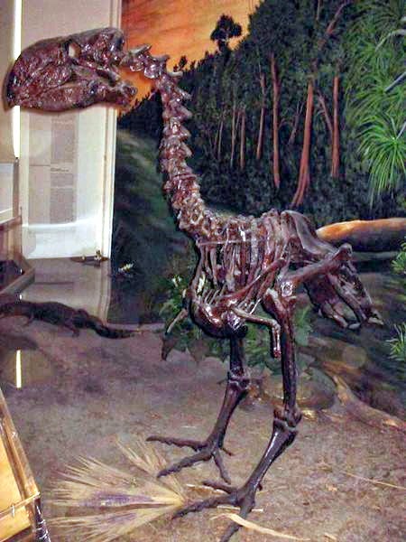
Gastornis fossil skeleton
Birds began to re-diversify during the epoch, occupying new niches. Most modern bird types had appeared by mid-Cenozoic, including perching birds, cranes, hawks, pelicans, herons, owls, ducks, pigeons, loons, and woodpeckers.
Large flightless birds have been found in late Paleocene deposits, including the herbivorous Gastornis in Europe and carnivorous terror birds in South America, the latter of which survived until the Pleistocene.
In the late Paleocene, early owl types appeared, such as Ogygoptynx in the United States and Berruornis in France.
Note : The above story is based on materials provided by Wikipedia
The Paleogene is a geologic period and system that began 66 and ended 23.03 million years ago and comprises the first part of the Cenozoic Era. Lasting 43 million years, the Paleogene is most notable as being the time in which mammals evolved from relatively small, simple forms into a large group of diverse animals in the wake of the Cretaceous–Paleogene extinction event that ended the preceding Cretaceous Period.
This period consists of the Paleocene, Eocene, and Oligocene Epochs. The end of the Paleocene (55.5/54.8 Mya) was marked by one of the most significant periods of global change during the Cenozoic, the Paleocene-Eocene Thermal Maximum, which upset oceanic and atmospheric circulation and led to the extinction of numerous deep-sea benthic foraminifera and on land, a major turnover in mammals. The Paleogene follows the Cretaceous Period and is followed by the Miocene Epoch of the Neogene Period. The terms ‘Paleogene System’ (formal) and ‘lower Tertiary System’ (informal) are applied to the rocks deposited during the ‘Paleogene Period’. The somewhat confusing terminology seems to be due to attempts to deal with the comparatively fine subdivisions of time possible in the relatively recent geologic past, when more information is preserved. By dividing the Tertiary Period into two periods instead of directly into five epochs, the periods are more closely comparable to the duration of ‘periods’ in the Mesozoic and Paleozoic Eras.
Climate and geography
The global climate during the Paleogene departed from the hot and humid conditions of the late Mesozoic era and began a cooling and drying trend which, although having been periodically disrupted by warm periods such as the Paleocene–Eocene Thermal Maximum, persists today. The trend was partly caused by the formation of the Antarctic Circumpolar Current, which significantly cooled oceanic water temperatures.The continents during the Paleogene continued to drift closer to their current positions. India was in the process of colliding with Asia, subsequently forming the Himalayas. The Atlantic Ocean continued to widen by a few centimeters each year. Africa was moving north to meet with Europe and form the Mediterranean, while South America was moving closer to North America (they would later connect via the Isthmus of Panama). Inland seas retreated from North America early in the period. Australia had also separated from Antarctica and was drifting towards Southeast Asia.
Mammals began a rapid diversification during this period. After the Cretaceous–Paleogene extinction event, which saw the demise of the non-avian dinosaurs, they transformed from a few small and generalized forms and began to evolve into most of the modern varieties we see today. Some of these mammals would evolve into large forms that would dominate the land, while others would become capable of living in marine, specialized terrestrial, and airborne environments. Some mammals took to the oceans and became modern cetaceans, while others took to the trees and became primates, the group to which humans belong. Birds, which were already well established by the end of the Cretaceous, also experienced an adaptive radiation as they took over the skies left empty by the now extinct Pterosaurs. Most other branches of life remained relatively unchanged in comparison to birds and mammals during this period.
As the Earth began to cool, tropical plants were less numerous and were now restricted to equatorial regions. Deciduous plants became more common, which could survive through the seasonal climate the world was now experiencing. One of the most notable floral developments during this period was the evolution of the first grass species. This new plant type expanded and formed new ecological environments we know today as savannas and prairies. These grasslands also began to replace many forests because they could survive better in the drier climate typical in many regions of the world during this period.
Geology
The Paleogene is notable in the context of offshore oil drilling, and especially in Gulf of Mexico oil exploration, where it is usually referred to as the “Lower Tertiary”. These rock formations represent the current cutting edge of deep-water oil discovery.Lower Tertiary rock formations encountered in the Gulf of Mexico oil industry tend to be comparatively high temperature and high pressure reservoirs, often with high sand content (70%+) or under very thick salt sediment layers.[8]
Lower Tertiary explorations to date include (partial list):
Kaskida Oil Field
Tiber Oil Field
Jack 2
The above story is based on materials provided by Wikipedia
Chemical Formula: (K,Ba)[Al(Si,Al)Si2O8] Locality: Imfield, Switzerland. Name Origin: From the Greek hyalos – “glass” and phanos – “to appear.”
Hyalophane or jaloallofane is a crystalline mineral, part of the feldspar group of tectosilicates. It is considered a barium-rich potassium feldspar. Its chemical formula is (K,Ba)[Al(Si,Al)Si2O8], and it has a hardness of 6 – 6½. The name hyalophane comes from the Greek hyalos, meaning “glass”, and phanos meaning “to appear”.
An occurrence of hyalophane was discovered in 1855 in Lengenbach Quarry, Imfield, in the municipality of Binn, Switzerland. The mineral is found predominantly in Europe, with occurrences in Switzerland, Australia, Bosnia, Germany, Japan, New Jersey, and the west coast of North America.
Physical Properties
Cleavage: {001} Perfect, {010} Imperfect Color: Colorless, Yellow, White, Red. Density: 2.81 Diaphaneity: Transparent to translucent Fracture: Brittle – Generally displayed by glasses and most non-metallic minerals. Hardness: 6-6.5 – Orthoclase-Pyrite Luminescence: Non-fluorescent. Luster: Vitreous (Glassy) Magnetism: Nonmagnetic Streak: white
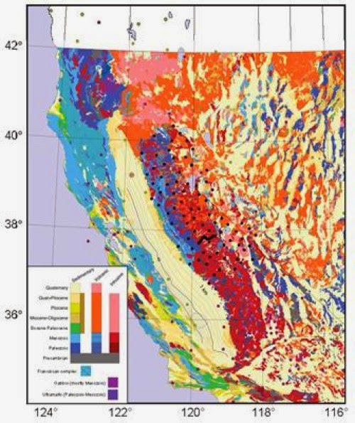
Geologic map showing seismic stations used in the study by C.H. Jones and colleagues, “P-wave tomography of potential convective down-wellings and their source regions, Sierra Nevada, California.” Credit: Image courtesy of Geological Society of America
In an addition to Geosphere’s ongoing themed issue series, “Geodynamics and Consequences of Lithospheric Removal in the Sierra Nevada, California,” Craig H. Jones of the University of Colorado Boulder and colleagues examine the seismological study of the entire extent of the U.S. Sierra Nevada range using seismograms collected in the Sierra Nevada EarthScope field experiment from 2005 to 2007.
Their results reveal that the entire eastern Sierra overlies low-velocity upper mantle and lacks the dense, quartz-poor lower crust that they say must have existed 80 million years ago when the granites of the range were created.
Jones and colleagues write that this missing dense material probably was removed within the past 10 million years. “Previous workers,” they note, “have suggested it might be within a high-velocity mantle anomaly under the southeastern San Joaquin Valley,” which is “the right size to be the old, dense rock previously under the eastern Sierra.”
They argue, however, that the geometry and extent of earth within the anomaly does not appear to be consistent with it being a piece of old subducted ocean floor. This would mean that a long strip of dense rock under the Sierra somehow deformed into a steeply plunging ellipsoid at the southwestern edge of the range. This conclusion suggests that the range rose within the past 10 million years as this dense material fell away to the west and south. Finally, Jones and colleagues note that something similar might be underway at the northern edge of the range.
Note : The above story is based on materials provided by Geological Society of America.
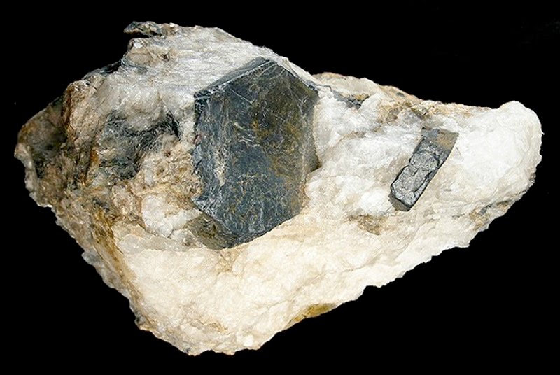
Chemical Formula: TlPbAs5S9 Locality: Binnental, Valais, Switzerland. Name Origin: Named for Arthur Hitchinson (1866-1937), Professor of Mineralogy, Cambridge University, England.
Hutchinsonite is a sulfosalt mineral of thallium, arsenic and lead with formula TlPbAs5S9. Hutchinsonite is a rare hydrothermal mineral.
It was first discovered in Binnental, Switzerland in 1904 and named after Cambridge mineralogist Arthur Hutchinson, F.R.S. (1866–1937).
Physical Properties
Cleavage: {100} Good Color: Cherry red, Pink, Black. Density: 4.6 Diaphaneity: Subtranslucent to opaque Fracture: Brittle – Conchoidal – Very brittle fracture producing small, conchoidal fragments. Hardness: 1.5-2 – Talc-Gypsum Luster: Sub Metallic Streak: red
Yellowstone National Park are fighting viral rumors of an impending, cataclysmic eruption of a mega volcano slumbering at the US Western preserve known for its geothermal features.
Volcanologists said reams of geological data have given them a deep of understanding of the Yellowstone Caldera—and all signs point to calm.
Over the past several weeks, the Internet has been abuzz with speculation over worrying signs suggesting an explosive awakening for the so-called supervolcano, whose last catastrophic eruption was 640,000 years ago.
That eruption covered a good portion of North America in ash several inches (centimeters) thick, and had a long-lasting impact on the Earth’s climate.
A video showing a herd of bison fleeing the iconic Wyoming park went viral.
And several days later, a 4.8-magnitude earthquake, the strongest in three decades, fed the rumor mill still further.
But Yellowstone spokesman Al Nash said there was nothing out of the ordinary in the animals’ behavior.
“We do have bison, elk and other animals that have moved out of the park recently,” he said.
“They tend to migrate at this time… to lower elevations, where they think they can get food, and then they come back.”
No cause for fear
As for the quake: “It was the strongest in 30 years, but it was not that strong,” said Peter Cervelli, a volcano expert at the US Geological Survey.
And such jolts are not exactly rare, with an estimated 1,000 to 3,000 quakes a year at the park.
Like many similar volcanoes in the world, Yellowstone’s has a way of breathing, the magma trapped underneath lifting or subsiding in phases.
And because the earth’s crust is just four to six miles (six to 10 kilometers) thick at Yellowstone, compared to an average of 18 miles, any pressure exerted by the magma is felt strongly.
“Recently, over the last six months, we are in an episode of uplift,” Cervelli said. “This probably explains the recent earthquake.”
But he rebuffed rumors that a big eruption was coming.
“I have not made yet an observation at Yellowstone that causes me to be afraid or causes me to wonder if an eruption was coming,” Cervelli said.
“We are always prepared to be surprised, and we don’t claim to understand everything perfectly.”
But he predicted there won’t be another major eruption “for the next ten thousands of years.”
His confidence was based in part on the many instruments, including dozens of GPS receivers and seismometers, that monitor activity in the volcano whose giant magma chamber measures 55 miles long, 18 miles wide and nine miles deep.
Around a dozen experts are also permanently stationed at Yellowstone.
Asteroid strike more likely
Geologist Ilya Bindeman was equally confident, based on his isotopic analysis of the minerals in the volcanic rocks at Yellowstone.
“We know the behavior of the past, and we know at what comparative stage Yellowstone is right now,” the University of Oregon professor explained.
And based on that analysis, the volcano is in the process of dying out.
“Caldera cycles go on for maybe several million years, and then it is done,” he said.
“I don’t think another major eruption is going to happen anytime soon—at least not for another one million to two million years.”
Such an eruption would destroy everything within a radius of several hundred miles and would cover North America in ash, putting an end to agriculture and cooling the Earth’s climate for at least 10 years.
The last time the Earth experienced such an eruption was in Indonesia, 70,000 years ago.
But the experts were in agreement: it’s nothing we will see during our lifetimes.
“We are more likely to see a major asteroid impact,” Cervelli said.
The Chambeshi River is the easternmost stream in red.
The Chambeshi (or Chambezi) River of northeastern Zambia is the most remote headstream of the Congo River (in terms of length) and therefore considered its source. (However, in terms of volume of water, the Lualaba River is the greater “source” of the Congo.)
The Chambeshi rises as a stream in the mountains of northeast Zambia near Lake Tanganyika at an elevation of 1760 metres above sea level. It flows for 480km into the Bangweulu Swamps, which are part of Lake Bangweulu, and by the end of the rainy season in May, it delivers a flood which recharges the swamps and inundates a vast floodplain to the southeast, supporting the Bangweulu Wetlands ecosystem. The water then flows out of the swamps as the Luapula River.
For more than 100 km of its length as it flows to the east of Kasama the river consists of a maze of channels in swamps about 2 km wide, in a floodplain up to 25 km wide. Further downstream, where it is bridged by the Kasama-Mpika road and the Tazara Railway, the permanent main channel is about 100 m wide, and up to 400 m wide in flood.
The above story is based on materials provided by Wikipedia
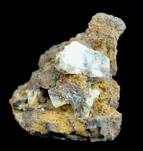
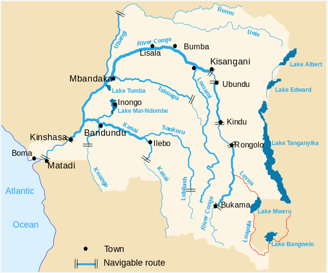
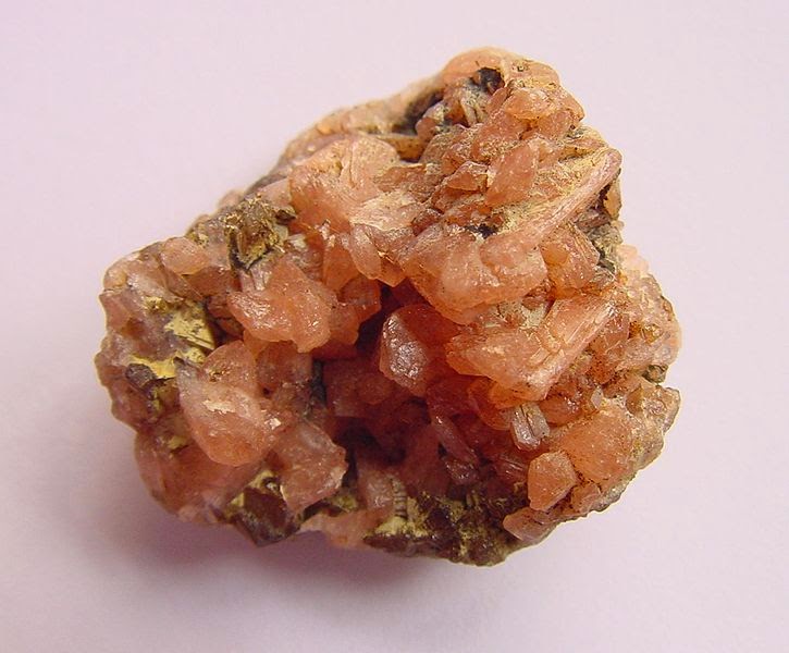
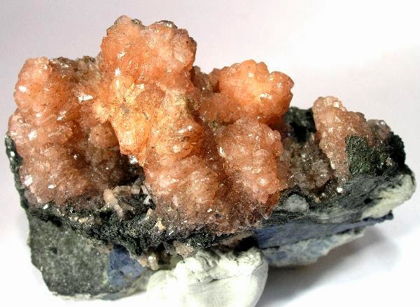
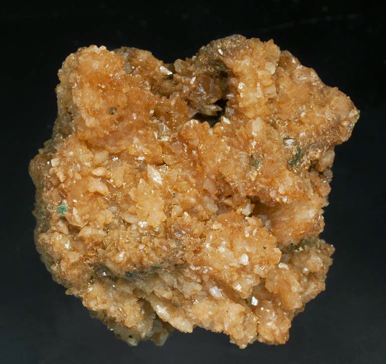
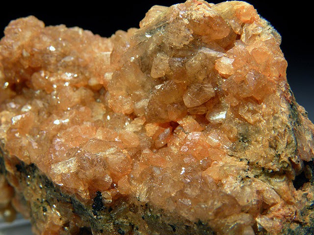
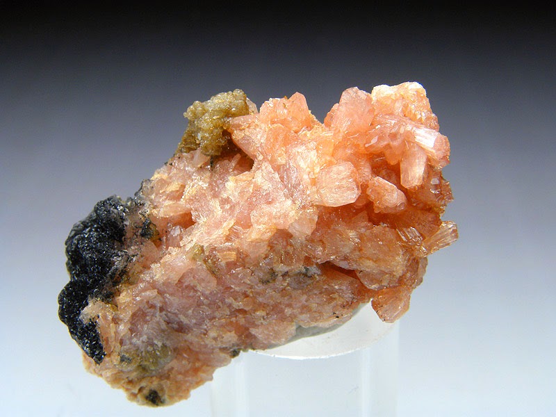
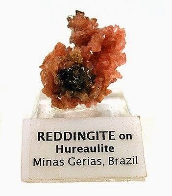
Chemical Formula: (Mn,Fe)5(PO4)2(HPO4)2·4H2O Locality: Hureaux in St. Silvestre and Vilate near Chanteloube, N of Limoges, Haute Vienne, France. Name Origin: Named for the locality.
Hureaulite is a manganese phosphate with the formula (Mn,Fe)5(PO4)2(HPO4)2·4H2O. It was discovered in 1825 and named in 1826 for the type locality, Les Hureaux, Saint-Sylvestre, Haute-Vienne, Limousin, France.
A complete series exists from lithiophilite, LiMn2+PO4 to triphylite, LiFe2+PO4, including hureaulite, strengite, FePO4·2H2O, stewartite, Mn2+Fe3+2(OH,PO4)2·8H2O, and sicklerite, (LiMn2+,Fe3+)PO4.
Some of the most famous and devastating natural disasters in history relate to volcano eruptions. It is estimated that more than 260 000 people have died in the past 300 years from eruptions and their aftermath. But volcanoes should not be judged as purely destructive forces – they may also have played a vital part in ensuring life could evolve on Earth and they may now be helping to slow down the warming of the atmosphere.
According to New Scientist, we now have the best evidence yet that volcanoes were responsible for pulling the Earth out of period of frigid chill over 600 million years ago. This may make them the driving force for evolutionary explosions that made life more diverse and laid the foundations for future animal species.
New Scientist reports that Ryan McKenzie of the University of Texas at Austin and colleagues have shown that volcanism may have shaped life during the crucial Cambrian period. Kenzie’s study of volcanic rocks from early in life’s evolutionary story shows that volcanic eruptions coincided with a change in the climate from frigid chill to sweltering heat.
This swing, and the way it affected the oceans, caused an explosion of evolutionary diversity, followed by a mass extinction when temperatures got too hot. Then, when Gondwana had formed and the volcanism died down, the planet cooled and life began to bloom again.
Volcanic activity during the formation of Gondwana had previously been suggested as a driver of these violent changes, but McKenzie’s new evidence (based on counts of zircon crystals formed in particular volcanic eruptions) strengthens the argument.
Volcanoes are also getting good press in the Guardian which reports on a study which focused extensively on volcanoes as a factor in the slowed warming of the atmosphere. In the study, Dr. Ben Santer and colleagues asked whether small volcanoes could be causing a slight reduction in the amount of sunlight that reaches the Earth.
The Guardian quotes co-author Carl Mears who says, ‘We were able to show that part of the cause of the recent lack of temperature increase is the large number of minor volcanic eruptions during the last 15 years. The ash and chemicals from these eruptions caused less sunlight than usual to arrive at the Earth’s surface, temporarily reducing the amount of temperature increase we measured at the surface and in the lower troposphere. The most recent round of climate models studied for the IPCC report did not adequately include the effects of these volcanoes, making their predictions show too much warming. For climate models to make accurate predictions, it is necessary that the input data that is fed into the model is accurate. Examples of input data include information about changes in greenhouse gases, atmospheric particles and solar output.’
Note : The above story is based on materials provided by CORDIS
An atomic force microscope image of the bacterial strain AltSIO. Credit: Alteromonas Scripps Institution of Oceanography
It’s broadly understood that the world’s oceans play a crucial role in the global-scale cycling and exchange of carbon between Earth’s ecosystems and atmosphere. Now scientists at Scripps Institution of Oceanography at UC San Diego have taken a leap forward in understanding the microscopic underpinnings of these processes.
When phytoplankton use carbon dioxide to make new cells, a substantial portion of that cellular material is released into the sea as a buffet of edible molecules collectively called “dissolved organic carbon.” The majority of these molecules are eventually eaten by microscopic marine bacteria, used for energy, and recycled back into carbon dioxide as the bacteria exhale. The amount of carbon that remains as cell material determines the role that ocean biology plays in locking up atmospheric carbon dioxide in the ocean.
Thus, these “recycling” bacteria play an important role in regulating how much of the planet’s carbon dioxide is stored in the oceans. The detailed mechanisms of how the oceans contribute to this global carbon cycle at the microscopic scale, and which microbes have a leadership role in the breakdown process, are complex and convoluted problems to solve.
In a study published in the Proceedings of the National Academy of Sciences, Scripps scientists have pinpointed a bacterium that appears to play a dominant role in carbon consumption. Scripps’s Byron Pedler, Lihini Aluwihare, and Farooq Azam found that a single bacterium called Alteromonas could consume as much dissolved organic carbon as a diverse community of organisms.
“This was a surprising result,” said Pedler. “Because this pool of carbon is comprised of an extremely diverse set of molecules, we believed that many different microbes with complementary abilities would be required to breakdown this material, but it appears that individual species may be pulling more weight than others when it comes to carbon cycling.”
Pedler, a marine biology graduate student at Scripps, spent several years working with Scripps marine microbiologist Azam and chemical oceanographer Aluwihare in designing a system that would precisely measure carbon consumption by individual bacterial species. Because carbon in organic matter is essentially all around us, the most challenging part of conducting these experiments is avoiding contamination.
“Much of the carbon cycling in the ocean happens unseen to the naked eye, and it involves a complex mix of processes involving microbes and molecules,” said Azam, a distinguished professor of marine microbiology. “The complexity and challenge is not just that we can’t see it but that there’s an enormous number of different molecules involved. The consequences of these microbial interactions are critically important for the global carbon cycle, and for us.”
By demonstrating that key individual species within the ecosystem can play a disproportionally large role in carbon cycling, this study helps bring us a step closer to understanding the function these microbes play in larger questions of climate warming and increased acidity in the ocean.
“In order to predict how ecosystems will react when you heat up the planet or acidify the ocean, we first need to understand the mechanisms of everyday carbon cycling—who’s involved and how are they doing it?” said Pedler. “Now that we have this model organism that we know contributes to ocean carbon cycling, and a model experimental system to study the process, we can probe further to understand the biochemical and genetic requirements for the breakdown of this carbon pool in the ocean.”
While the new finding exposes the unexpected capability of a significant species in carbon cycling, the scientists say there is much more to the story since whole communities of microbes may interact together or live symbiotically in the microscopic ecosystems of the sea.
Pedler, Aluwihare, and Azam are now developing experiments to test other microbes and their individual abilities to consume carbon.
Note : The above story is based on materials provided by University of California – San Diego
Chemical Formula: (Fe2+,Mg)2(Fe3+,Sn)(BO3)O2 Locality: Brooks mountain, Seward peninsula, Alaska. Name Origin: Named for Alfred Hulse Brooks (1871-1924), U. S. Geologist.
Physical Properties
Cleavage: {110} Good Color: Black. Density: 4.3 Diaphaneity: Opaque Hardness: 3 – Calcite Luminescence: Non-fluorescent. Luster: Sub Metallic Streak: black
New research has shown that there was liquid water on Mars as recently as 200,000 years ago. The results have been published in the international scientific journal Icarus.
“We have discovered a very young crater in the southern mid-latitudes of Mars that shows evidence of liquid water in Mars’ recent past” says Andreas Johnsson at the University of Gothenburg.
The southern hemisphere of Mars is home to a crater that contains very well-preserved gullies and debris flow deposits. The geomorphological attributes of these landforms provide evidence that they were formed by the action of liquid water in geologically recent time.
Evidence of liquid water
When sediment on a slope becomes saturated with water, the mixture may become too heavy to remain in place, leading to a flow of debris and water as a single-phase unit. This is called a debris flow. Debris flows on Earth often cause significant material destruction and even human casualties, when they occur in built-up areas. During a debris flow, a mixture of stones, gravel, clay and water moves rapidly down a slope. When the sediment subsequently stops, it displays characteristic surface features such as lobate deposits and paired levees along flow channels.
It is these landforms that Andreas Johnsson has identified on Mars. The research group has been able to compare the landforms on Mars with known debris flows on Svalbard with the aid of aerial photography and field studies. The debris flows on Mars provide evidence that liquid water has been present in the region.
“Our fieldwork on Svalbard confirmed our interpretation of the Martian deposits. What surprised us was that the crater in which these debris flows have formed is so young,” says Andreas Johnsson of the Department of Earth Sciences, University of Gothenburg.
After the ice age
Crater statistics allowed Andreas Johnsson and his co-authors to determine that the age of the crater to be approximately 200,000 years. This means that the crater was formed long after the most recent proposed ice age on Mars, which ended around 400,000 years ago.
“Gullies are common on Mars, but the ones which have been studied previously are older, and the sediments where they have formed are associated with the most recent ice age. Our study crater on Mars is far too young to have been influenced by the conditions that were prevalent then. This suggests that the meltwater-related processes that formed these deposits have been exceptionally effective also in more recent times,” says Andreas Johnsson, principal author of the article.
Impact in wet ground
The study crater is situated in the mid-latitudes of Mars’ southern hemisphere, superposed on what is known as the rampart ejecta of a nearby larger crater. A rampart ejecta display a “flowerlike” form around the host crater, and scientists have interpreted this as being the result of an impact in wet or ice-rich ground.
“My first thought was that the water that formed these debris flows had come from preserved ice within the rampart ejecta. But when we looked more closely, we didn’t find any structures such as faults or fractures in the crater that could have acted as conduits for the meltwater. It is more likely that the water has come from melting snow packs, when the conditions were favorable for snow formation. This is possible, since the orbital axis of Mars was more tilted in the past than it is today,” says Andreas Johnsson.
Note : The above story is based on materials provided by University of Gothenburg.
Simplified model for the tectonic evolution of the Taconic orogeny and closure of the Iapetus Ocean. Horizontal distances are not to scale.
When and where did the ancient Iapetus Ocean suture (the most fundamental Appalachian structure) form? Is part of New England made up of ancient African-derived rocks? What is the Moretown terrane? This new GEOLOGY study by researchers from Harvard, Middlebury College, Boise State University, and Williams College finds new evidence for an earlier closing of the Iapetus that is farther west than previous studies have reported.
Mountain-building events, called “orogenies,” in the northern U.S. Appalachia record the closure of the Iapetus Ocean, an ancient precursor to the Atlantic. The Iapetus separated continental fragments of ancestral North America and Africa more than 450 million years ago
The mountain-building period that affected most of modern-day New England, known as the “Taconic orogeny,” is commonly depicted as a collision during the Ordovician period (435 to 500 million years ago) of a North American-derived arc (the Shelburne Falls arc) and the North American margin, followed by accretion of African-derived terranes (groups of rocks with geologic histories different from surrounding rocks) during the Silurian period (410 to 435 million years ago).
New uranium-lead (U-Pb) zircon dating presented here by Harvard researcher Francis A. Macdonald and colleagues demonstrates instead that the Shelburne Falls arc was constructed on an African-derived terrane, which they have named the Moretown terrane. Their geochronologic data reveal that the main Iapetan suture, which marks the location of the Iapetus as it was consumed through subduction, is more than 50 km west than previously suspected.
Macdonald and colleagues conclude that the Moretown terrane lies below North American-derived volcanic and sedimentary rocks of the Hawley Formation, which proves a link between North American- and African-derived terranes. The Moretown terrane and Hawley Formation were both intruded by 475-million-year-old plutonic rocks (rocks formed by magma rising from great depths beneath Earth’s surface), suggesting that these terranes were together by this time and that the Iapetus Ocean closed approx. 20 million years earlier than documented elsewhere.
Note : The above story is based on materials provided by Geological Society of America, The.
Chemical Formula: MnWO4 Locality: Erie and Enterprise veins, Ellsworth (Mammoth) district, Nye County, Nevada, USA. Name Origin: After the German mineralogist, Adolph Huebner.
Hübnerite or hubnerite is a mineral consisting of manganese tungsten oxide (chemical formula: MnWO4, it isn’t a tungstate). It is the manganese endmember of the manganese – iron wolframite solid solution series. It forms reddish brown to black monoclinic prismatic submetallic crystals. The crystals are typically flattened and occur with fine striations. It has a high specific gravity of 7.15 and a Mohs hardness of 4.5. It is transparent to translucent with perfect cleavage. Refractive index values are nα=2.170 – 2.200, nβ=2.220, and nγ=2.300 – 2.320.
Typical occurrence is in association with high-temperature hydrothermal vein deposits and altered granites with greisen, granite pegmatites and in alluvial deposits. It occurs associated with cassiterite, arsenopyrite, molybdenite, tourmaline, topaz, rhodochrosite and fluorite.
It was first described in 1865 for an occurrence in the Erie and Enterprise veins, Mammoth district, Nye County, Nevada, and named after the German mining engineer and metallurgist, Adolf Huebner from Freiberg, Saxony
Physical Properties
Cleavage: {010} Perfect Color: Brown, Reddish brown, Brownish black. Density: 7.2 – 7.1, Average = 7.15 Diaphaneity: Transparent to Translucent Fracture: Brittle – Generally displayed by glasses and most non-metallic minerals. Hardness: 4.5 – Between Fluorite and Apatite Luster: Sub Metallic Streak: reddish brown