The Late Cretaceous (100.5–66 Ma) is the younger of two epochs into which the Cretaceous period is divided in the geologic timescale. Rock strata from this epoch form the Upper Cretaceous series. The Cretaceous is named after the white limestone known as chalk which occurs widely in northern France and is famously seen in the white cliffs of south-eastern England, and which dates from this time.
Climate
During the Late Cretaceous, the climate was warmer than present, although throughout the period a cooling trend is evident. The tropics became restricted to equatorial regions and northern latitudes experienced markedly more seasonal climatic conditions.
Geography
Due to plate tectonics, the Americas were gradually moving westward, causing the Atlantic Ocean to expand. The Western Interior Seaway divided North America into eastern and western halves; Appalachia and Laramidia. India maintained a northward course towards Asia. In the Southern Hemisphere, Australia and Antarctica seem to have remained connected and began to drift away from Africa and South America. Europe was an island chain. Populating some of these islands were endemic dwarf dinosaur species.
Vertebrate fauna
Dinosaurs
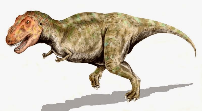
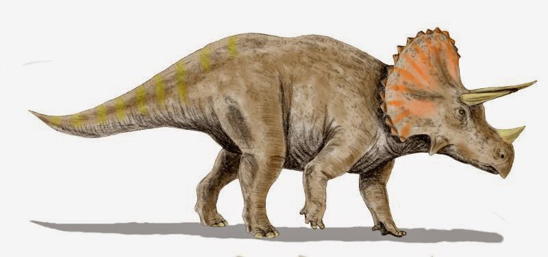
This was a period of great success for dinosaurs, with many new types appearing and diversifying. The duck bills, Ankylosauridae, and horned dinosaurs experienced success in Asiamerica (Western North America and eastern Asia). Tyrannosaurs dominated the large predator niche in North America.They were also present in Asia, although were usually smaller and more primitive than the North American varieties. Pachycephalosaurs were also present in both North America and Asia. Dromaeosaurs shared the same geographical distribution, and are well documented in both Mongolia and Western North America.By contrast therizinosaurs (known previously as segnosaurs) appear to have been living solely in Asia. Gondwana held a very different dinosaurian fauna, with most predators being abelisaurs and carcharodontosaurs; and titanosaurs being among the dominant herbivores.
Birds
Birds became increasingly common and diverse, replacing the pterosaurs which retreated to increasingly specialised ecological niches.
Mammals
Didelphid marsupials and primitive placental mammals also became common. Still, mammals remained small.
Marine life
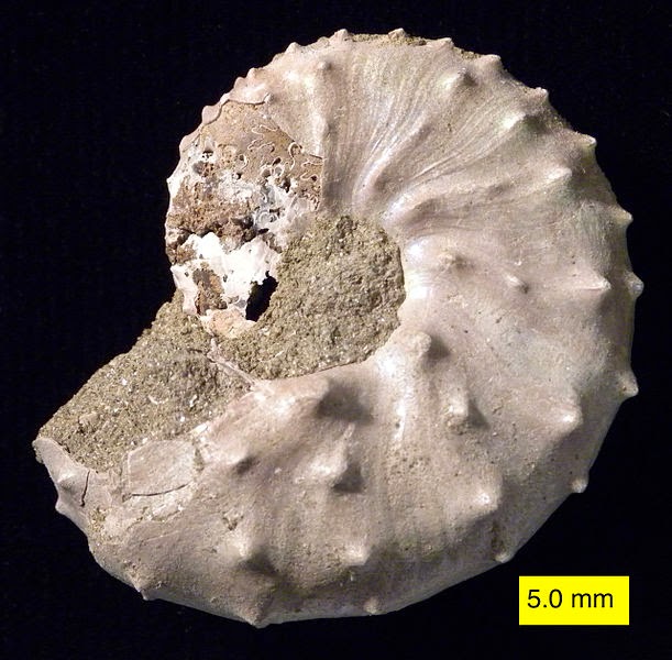
In the seas, mosasaurs suddenly appeared and underwent a spectacular evolutionary radiation. Modern sharks also appeared and giant-penguin-like polycotylid plesiosaurs (3 meters long) and huge long-necked elasmosaurs (13 meters long) also diversified. These predators fed on the numerous teleost fishes, which in turn evolved into new advanced and modern forms (Neoteleostei). Ichthyosaurs and pliosaurs, on the other hand, went extinct during the Cenomanian-Turonian anoxic event.
Flora
Near the end of the Cretaceous Period, flowering plants diversified. In temperate regions, familiar plants like magnolias, sassafras, roses, redwoods, and willows could be found in abundance.
Cretaceous–Paleogene mass extinction
The Cretaceous–Paleogene extinction event was a large-scale mass extinction of animal and plant species in a geologically short period of time, approximately 66 million years ago (Ma). It is widely known as the K–T extinction event and is associated with a geological signature, usually a thin band dated to that time and found in various parts of the world, known as the Cretaceous–Paleogene boundary (K–T boundary). K is the traditional abbreviation for the Cretaceous Period derived from the German name Kreidezeit, and T is the abbreviation for the Tertiary Period (a historical term for the period of time now covered by the Paleogene and Neogene periods). The event marks the end of the Mesozoic Era and the beginning of the Cenozoic Era. “Tertiary” being no longer recognized as a formal time or rock unit by the International Commission on Stratigraphy, the K-T event is now called the Cretaceous—Paleogene (or K-Pg) extinction event by many researchers.Non-avian dinosaur fossils are only found below the Cretaceous–Paleogene boundary and became extinct immediately before or during the event. A very small number of dinosaur fossils have been found above the Cretaceous–Paleogene boundary, but they have been explained as reworked fossils, that is, fossils that have been eroded from their original locations then preserved in later sedimentary layers.Mosasaurs, plesiosaurs, pterosaurs and many species of plants and invertebrates also became extinct. Mammalian and bird clades passed through the boundary with few extinctions, and evolutionary radiation from those Maastrichtian clades occurred well past the boundary. Rates of extinction and radiation varied across different clades of organisms.
Scientists have hypothesized that the Cretaceous–Paleogene extinctions were caused by one or more catastrophic events such as massive asteroid impacts or increased volcanic activity. Several impact craters and massive volcanic activity in the Deccan traps have been dated to the approximate time of the extinction event. These geological events may have reduced sunlight and hindered photosynthesis, leading to a massive disruption in Earth’s ecology. Other researchers believe the extinction was more gradual, resulting from slower changes in sea level or climate.
Note : The above story is based on materials provided by Wikipedia
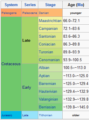
Subdivision of the Cretaceous system according to the IUGS, as of July 2012.
The Early Cretaceous (geochronological name) or the Lower Cretaceous (chronostratigraphic name), is the earlier or lower of the two major divisions of the Cretaceous. It is usually considered to stretch from 146 Ma to 100 Ma.
During this time many new types of dinosaurs appeared or came into prominence, including Psittacosaurus, spinosaurids, carcharodontosaurids and coelurosaurs, while survivors from the Late Jurassic continued.
In the seas, the ichthyosaurs declined and eventually died out at the start of the Late Cretaceous. Angiosperms (flowering plants) appear for the first time.
Note : The above story is based on materials provided by Wikipedia
The Cretaceous , derived from the Latin “creta” (chalk), usually abbreviated K for its German translation Kreide (chalk), is a geologic period and system from circa 145 ± 4 to 66 million years (Ma) ago. In the geologic timescale, the Cretaceous follows the Jurassic period and is followed by the Paleogene period of the Cenozoic era. It is the last period of the Mesozoic Era, and, spanning 79 million years, the longest period of the Phanerozoic Eon.
The Cretaceous was a period with a relatively warm climate, resulting in high eustatic sea levels and creating numerous shallow inland seas. These oceans and seas were populated with now extinct marine reptiles, ammonites and rudists, while dinosaurs continued to dominate on land. At the same time, new groups of mammals and birds, as well as flowering plants, appeared. The Cretaceous ended with a large mass extinction, the Cretaceous–Paleogene extinction event, in which many groups, including non-avian dinosaurs, pterosaurs and large marine reptiles, died out. The end of the Cretaceous is defined by the K–Pg boundary, a geologic signature associated with the mass extinction which lies between the Mesozoic and Cenozoic eras.
Geology
Research history
The Cretaceous as a separate period was first defined by Belgian geologist Jean d’Omalius d’Halloy in 1822, using strata in the Paris Basin and named for the extensive beds of chalk (calcium carbonate deposited by the shells of marine invertebrates, principally coccoliths), found in the upper Cretaceous of western Europe. The name Cretaceous was derived from Latin creta, meaning chalk.
Stratigraphic subdivisions
The Cretaceous is divided into Early and Late Cretaceous epochs or Lower and Upper Cretaceous series. In older literature the Cretaceous is sometimes divided into three series: Neocomian (lower/early), Gallic (middle) and Senonian (upper/late). A subdivision in eleven stages, all originating from European stratigraphy, is now used worldwide. In many parts of the world, alternative local subdivisions are still in use.
As with other older geologic periods, the rock beds of the Cretaceous are well identified but the exact ages of the system’s base is uncertain by a few million years. No great extinction or burst of diversity separates the Cretaceous from the Jurassic. However, the top of the system is sharply defined, being placed at an iridium-rich layer found worldwide that is believed to be associated with the Chicxulub impact crater; with its boundaries circumscribing parts of the Yucatán Peninsula and into the Gulf of Mexico. This layer has been dated at 66.043 Ma.
Rock formations
The high eustatic sea level and warm climate of the Cretaceous meant a large area of the continents was covered by warm shallow seas. The Cretaceous was named for the extensive chalk deposits of this age in Europe, but in many parts of the world, the Cretaceous system consists for a major part of marine limestone, a rock type that is formed under warm, shallow marine circumstances. Due to the high sea level there was extensive accommodation space for sedimentation so that thick deposits could form. Because of the relatively young age and great thickness of the system, Cretaceous rocks crop out in many areas worldwide.
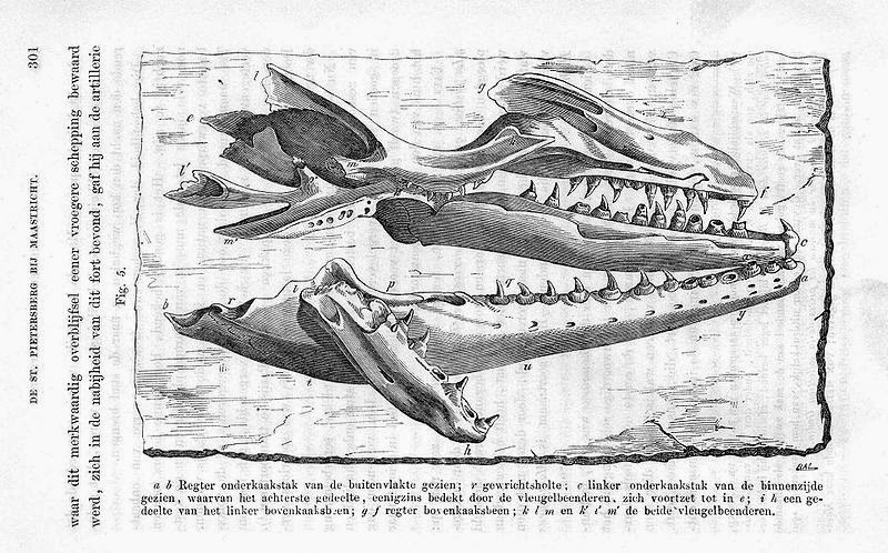
Drawing of fossil jaws of Mosasaurus hoffmanni, from the Maastrichtian of Dutch Limburg, by Dutch geologist Pieter Harting (1866).
Chalk is a rock type characteristic for (but not restricted to) the Cretaceous. It consists of coccoliths, microscopically small calcite skeletons of coccolithophores, a type of algae that prospered in the Cretaceous seas.
In northwestern Europe, chalk deposits from the Upper Cretaceous are characteristic for the Chalk Group, which forms the white cliffs of Dover on the south coast of England and similar cliffs on the French Normandian coast. The group is found in England, northern France, the low countries, northern Germany, Denmark and in the subsurface of the southern part of the North Sea. Chalk is not easily consolidated and the Chalk Group still consists of loose sediments in many places. The group also has other limestones and arenites. Among the fossils it contains are sea urchins, belemnites, ammonites and sea reptiles such as Mosasaurus.
In southern Europe, the Cretaceous is usually a marine system consisting of competent limestone beds or incompetent marls. Because the Alpine mountain chains did not yet exist in the Cretaceous, these deposits formed on the southern edge of the European continental shelf, at the margin of the Tethys Ocean.
Stagnation of deep sea currents in middle Cretaceous times caused anoxic conditions in the sea water. In many places around the world, dark anoxic shales were formed during this interval. These shales are an important source rock for oil and gas, for example in the subsurface of the North Sea.
Paleogeography
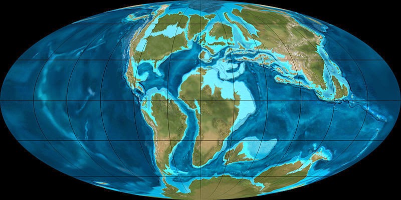
During the Cretaceous, the late-Paleozoic-to-early-Mesozoic supercontinent of Pangaea completed its tectonic breakup into present day continents, although their positions were substantially different at the time. As the Atlantic Ocean widened, the convergent-margin orogenies that had begun during the Jurassic continued in the North American Cordillera, as the Nevadan orogeny was followed by the Sevier and Laramide orogenies.
Though Gondwana was still intact in the beginning of the Cretaceous, it broke up as South America, Antarctica and Australia rifted away from Africa (though India and Madagascar remained attached to each other); thus, the South Atlantic and Indian Oceans were newly formed. Such active rifting lifted great undersea mountain chains along the welts, raising eustatic sea levels worldwide. To the north of Africa the Tethys Sea continued to narrow. Broad shallow seas advanced across central North America (the Western Interior Seaway) and Europe, then receded late in the period, leaving thick marine deposits sandwiched between coal beds. At the peak of the Cretaceous transgression, one-third of Earth’s present land area was submerged.
The Cretaceous is justly famous for its chalk; indeed, more chalk formed in the Cretaceous than in any other period in the Phanerozoic. Mid-ocean ridge activity—or rather, the circulation of seawater through the enlarged ridges—enriched the oceans in calcium; this made the oceans more saturated, as well as increased the bioavailability of the element for calcareous nanoplankton. These widespread carbonates and other sedimentary deposits make the Cretaceous rock record especially fine. Famous formations from North America include the rich marine fossils of Kansas’s Smoky Hill Chalk Member and the terrestrial fauna of the late Cretaceous Hell Creek Formation. Other important Cretaceous exposures occur in Europe (e.g., the Weald) and China (the Yixian Formation). In the area that is now India, massive lava beds called the Deccan Traps were erupted in the very late Cretaceous and early Paleocene.
Climate
The Berriasian epoch showed a cooling trend that had been seen in the last epoch of the Jurassic. There is evidence that snowfalls were common in the higher latitudes and the tropics became wetter than during the Triassic and Jurassic. Glaciation was however restricted to alpine glaciers on high-latitude mountains, though seasonal snow may have existed farther from the poles. Rafting by ice of stones into marine environments occurred during much of the Cretaceous but evidence of deposition directly from glaciers is limited to the Early Cretaceous of the Eromanga Basin in southern Australia.After the end of the Berriasian, however, temperatures increased again, and these conditions were almost constant until the end of the period. This trend was due to intense volcanic activity which produced large quantities of carbon dioxide. The production of large quantities of magma, variously attributed to mantle plumes or to extensional tectonics, further pushed sea levels up, so that large areas of the continental crust were covered with shallow seas. The Tethys Sea connecting the tropical oceans east to west also helped in warming the global climate. Warm-adapted plant fossils are known from localities as far north as Alaska and Greenland, while dinosaur fossils have been found within 15 degrees of the Cretaceous south pole.
A very gentle temperature gradient from the equator to the poles meant weaker global winds, contributing to less upwelling and more stagnant oceans than today. This is evidenced by widespread black shale deposition and frequent anoxic events. Sediment cores show that tropical sea surface temperatures may have briefly been as warm as 42 °C (107 °F), 17 °C ( 31 °F) warmer than at present, and that they averaged around 37 °C (99 °F). Meanwhile deep ocean temperatures were as much as 15 to 20 °C (27 to 36 °F) higher than today’s.
Life
Flora
Flowering plants (angiosperms) spread during this period, although they did not become predominant until the Campanian stage near the end of the epoch. Their evolution was aided by the appearance of bees; in fact angiosperms and insects are a good example of coevolution. The first representatives of many leafy trees, including figs, planes and magnolias, appeared in the Cretaceous. At the same time, some earlier Mesozoic gymnosperms continued to thrive; pehuéns (monkey puzzle trees, Araucaria) and other conifers being notably plentiful and widespread. Some fern orders such as Gleicheniales appeared as early in the fossil record as the Cretaceous, and achieved an early broad distribution. Gymnosperm taxa like Bennettitales died out before the end of the period.
On land, mammals were a small and still relatively minor component of the fauna. Early marsupial mammals evolved in the Early Cretaceous, with true placentals emerging in the Late Cretaceous period. The fauna was dominated by archosaurian reptiles, especially dinosaurs, which were at their most diverse stage. Pterosaurs were common in the early and middle Cretaceous, but as the Cretaceous proceeded they declined for poorly understood reasons (once thought to be due to competition with early birds, but now it is understood avian adaptative radiation is not consistent with pterosaur decline), and by the end of the period only two highly specialized families remained.
The Liaoning lagerstätte (Chaomidianzi formation) in China provides a glimpse of life in the Early Cretaceous, where preserved remains of numerous types of small dinosaurs, birds and mammals have been found. The coelurosaur dinosaurs found there represent types of the group Maniraptora, which is transitional between dinosaurs and birds, and are notable for the presence of hair-like feathers.
Insects diversified during the Cretaceous, and the oldest known ants, termites and some lepidopterans, akin to butterflies and moths, appeared. Aphids, grasshoppers and gall wasps appeared.
In the seas, rays, modern sharks and teleosts became common. Marine reptiles included ichthyosaurs in the early and mid-Cretaceous (becoming extinct during the late Cretaceous Cenomanian-Turonian anoxic event), plesiosaurs throughout the entire period, and mosasaurs appearing in the Late Cretaceous.
Baculites, an ammonite genus with a straight shell, flourished in the seas along with reef-building rudist clams. The Hesperornithiformes were flightless, marine diving birds that swam like grebes. Globotruncanid Foraminifera and echinoderms such as sea urchins and starfish (sea stars) thrived. The first radiation of the diatoms (generally siliceous, rather than calcareous) in the oceans occurred during the Cretaceous; freshwater diatoms did not appear until the Miocene. The Cretaceous was also an important interval in the evolution of bioerosion, the production of borings and scrapings in rocks, hardgrounds and shells (Taylor and Wilson, 2003).
There was a progressive decline in biodiversity during the Maastrichtian stage of the Cretaceous period prior to the suggested ecological crisis induced by events at the K–Pg boundary (K–T boundary). Furthermore, biodiversity required a substantial amount of time to recover from the K–T event, despite the probable existence of an abundance of vacant ecological niches.
Despite the severity of this boundary event, there was significant variability in the rate of extinction between and within different clades. Species which depended on photosynthesis declined or became extinct because of the reduction in solar energy reaching the Earth’s surface due to atmospheric particles blocking the sunlight. As is the case today, photosynthesizing organisms, such as phytoplankton and land plants, formed the primary part of the food chain in the late Cretaceous. Evidence suggests that herbivorous animals, which depended on plants and plankton as their food, died out as their food sources became scarce; consequently, top predators such as Tyrannosaurus rex also perished.
Coccolithophorids and molluscs, including ammonites, rudists, freshwater snails and mussels, as well as organisms whose food chain included these shell builders, became extinct or suffered heavy losses. For example, it is thought that ammonites were the principal food of mosasaurs, a group of giant marine reptiles that became extinct at the boundary.
Omnivores, insectivores and carrion-eaters survived the extinction event, perhaps because of the increased availability of their food sources. At the end of the Cretaceous there seem to have been no purely herbivorous or carnivorous mammals. Mammals and birds which survived the extinction fed on insects, larvae, worms and snails, which in turn fed on dead plant and animal matter. Scientists theorise that these organisms survived the collapse of plant-based food chains because they fed on detritus.
In stream communities, few groups of animals became extinct. Stream communities rely less on food from living plants and more on detritus that washes in from land. This particular ecological niche buffered them from extinction. Similar, but more complex patterns have been found in the oceans. Extinction was more severe among animals living in the water column, than among animals living on or in the sea floor. Animals in the water column are almost entirely dependent on primary production from living phytoplankton, while animals living on or in the ocean floor feed on detritus or can switch to detritus feeding.
The largest air-breathing survivors of the event, crocodilians and champsosaurs, were semi-aquatic and had access to detritus. Modern crocodilians can live as scavengers and can survive for months without food and go into hibernation when conditions are unfavourable, and their young are small, grow slowly, and feed largely on invertebrates and dead organisms or fragments of organisms for their first few years. These characteristics have been linked to crocodilian survival at the end of the Cretaceous.
Note : The above story is based on materials provided by Wikipedia
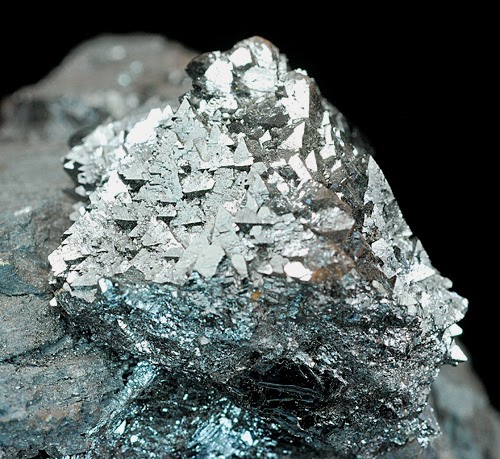
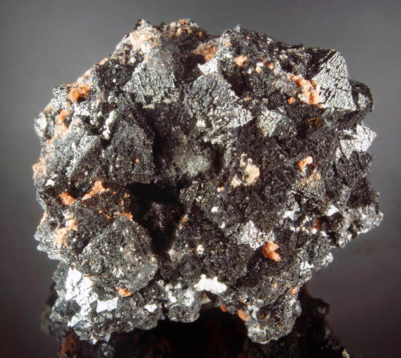
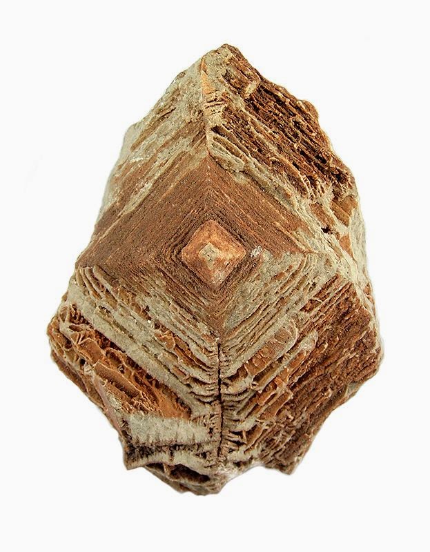
Chemical Formula: Mn2+Mn23+O4 Locality: Ilmenau and nearby at Orenstock, in Thuringia, Germany. Name Origin: Named after the German mineralogist, J. F. L. Hausmann (1782-1859).
Hausmannite is a complex oxide of manganese containing both di- and tri-valent manganese. The formula can be represented as Mn2+Mn23+O4. It belongs to the spinel group and forms tetragonal crystals. Hausmannite is a brown to black metallic mineral with Mohs hardness of 5.5 and a specific gravity of 4.8. The type locality is Oehrenstock (Öhrenstock), Ilmenau, Thuringian Forest, Thuringia, Germany. Locations include Batesville, Arkansas, USA; Ilfeld, Germany; Langban, Sweden; and the Ural Mountains, Russia. The best samples have been found in South Africa and Namibia where it is associated with other manganese oxides, pyrolusite and psilomelane and the iron-manganese mineral bixbyite. Wilhelm Haidinger (1827) named it in honour of Johann Friedrich Ludwig Hausmann (1782–1859), professor of mineralogy, University of Göttingen, Germany.
Physical Properties
Cleavage: {001} Perfect Color: Brownish black, Grayish. Density: 4.7 – 4.84, Average = 4.76 Diaphaneity: Opaque Fracture: Uneven – Flat surfaces (not cleavage) fractured in an uneven pattern. Hardness: 5.5 – Knife Blade Luminescence: Non-fluorescent. Luster: Sub Metallic Magnetism: Nonmagnetic Streak: dark reddish brown
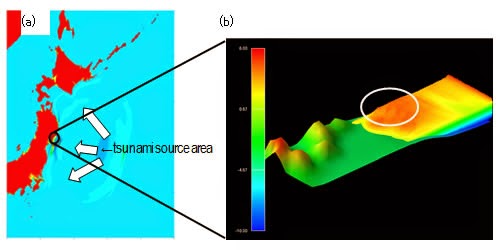
Figure 1 (a) Replicating a tsunami over a wide area extending from its source area to coastal areas (b) Replicating the 3D behavior of a tsunami as it flows into coastal areas
Fujitsu Limited today announced that, based on its joint research with Tohoku University that began in 2012, the two have developed a 3D tsunami simulator that can replicate in fine detail the surge of water in urban areas as well as river surges caused by a tsunami. The joint research succeeded in combining a 2D tsunami-propagation simulation technology developed by Professor Fumihiko Imamura, director of the International Research Institute of Disaster Science in Tohoku University with Fujitsu’s 3D fluid simulation technology. As a result, the researchers were able to accurately replicate the complex changes a tsunami undergoes as it interacts with coastal topography or buildings in urban areas, as well as the process of water surges in urban areas and rivers.
To apply the simulator toward composite disaster forecasting of a tsunami caused by a major earthquake, the researchers plan to use it in the Strategic Programs for Innovative Research (HPCI), promoted by MEXT, in which one of the themes is improved tsunami forecasting techniques using the HPCI computer with the aim of helping make Japan more resilient to disasters.
Background
The Great East Japan Earthquake of March 11, 2011, and the tsunami it caused devastated the Tohoku region. In light of this bitter experience, to implement effective measures that would minimize the damage cause by major earthquakes and tsunamis in the future, there is a great need to use large-scale simulation technology to elucidate the mechanisms behind the structural failure of buildings and for high-precision damage forecasting.
For that reason, in February 2012 Fujitsu began joint research with Professor Imamura of Tohoku University, who is Japan’s preeminent tsunami researcher, to develop a high-precision 3D tsunami simulator.
Issues in the Joint Research
The 2D tsunami-propagation simulation technology developed by Tohoku University’s Professor Imamura is widely used to calculate the arrival time and wave height of a tsunami along coastal areas. However, the problem was in being able to precisely replicate urban inundation and river surges; it was difficult to incorporate 3D data, such as the shapes of buildings or levees, which affect the power of the tsunami and the flow velocity of surges.
On the other hand, Fujitsu’s 3D fluid simulation technology uses a smoothed-particle hydrodynamic technique in which fluid is treated as a collection of numerous particles. This gives it the advantage of being able to replicate 3D behavior, such as that of wave breaks and overflow. The problem, however, was the very heavy computing load, making it difficult to perform simulations over a wide area extending from the tsunami source area to a coastal area.
The Joint Research
Fujitsu and Tohoku University worked together to integrate the data on wave height and flow velocity replicated using the 2D tsunami-propagation simulation technology into the 3D fluid simulation technology. By combining these two technologies, the researchers developed a 3D tsunami simulator.
Effects
The action of the tsunami over the wide area extending from the hypocenter source to the coastal areas was replicated using the 2D simulation technology (figure 1 (a)), for which the computing loads are comparatively light, and the 3D fluid simulation technology was used just on the coastal regions and the urban areas, where such phenomena as wave breaks and overflow occur, enabling the 3D movements of the tsunami to be replicated within a period of time that is reasonable for practical use.
Figure 1 (b) shows the replication using the 3D fluid simulation technology. It replicates the action of the tsunami on the coastal areas, which could not be done with either the 2D simulation technology or the 3D fluid simulation technology alone. In the white circle, one can see the effects of the overlaps between the tsunami flowing straight to the shore with other tsunami waves wrapping around it, and one can also see formation of the complex flows of the tsunami as it is affected by the topography of the seafloor in shallower waters.
With the 3D tsunami simulator, the complex flows of the tsunami from its hypocenter source, as well as the behavior of wave breaks and overflow on the coastal areas can be replicated. As a result, it is hoped the damage caused by the impact force of the tsunami as it launches up over the breakwaters and then crashes down will be able to be more precisely estimated.
In addition, because such variables as wave height and flow velocity can be replicated using the 2D tsunami-propagation simulation technology, for which the computing loads are comparatively light, the time required for replication can be shortened compared to simulations using just the 3D fluid simulation technology, alone, for which computing loads are heavy.
For example, a simulation of a tsunami from its source area to urban areas on shore using only the 3D fluid simulation technology, would, even using a 10,000-node supercomputer system, require over 200 years to perform the calculations, making it infeasible. Using the newly developed 3D tsunami simulator, however, to precisely replicate an approximately 0.5m radius in a tsunami traveling over approximately 10 square kilometers, which is equivalent to one harbor or bay, would require approximately 160 hours of computing using a 10,000-node supercomputer. This therefore could be put to practical use as a solution that supports disaster mitigation efforts by forecasting the effects of measures taken to deal with tsunamis, such as by using coastal structures.
*Details of this technology will be announced by Fujitsu as well as Professor Imamura and Assistant Professor Daisuke Sugawara of Tohoku University at the 1st International Conference on Computational Engineering and Science for Safety and Environmental Problems (COMPSAFE 2014), which will be held April 13-16 in Sendai, Japan.
Future Plans
Going forward, as a step to applying this technology to damage forecasting in a complex disaster involving a major earthquake and associated tsunami, the researchers want to use it in the third of five fields of the Strategic Programs for Innovative Research, “Advanced Prediction Researches for Natural Disaster Prevention and Reduction,” for the theme “Improvement of the tsunami forecasting system on the HPCI computer.” In this research, a consortium of research institutes, led by Tohoku University, plan to integrate a variety of tsunami damage forecasting methods with evacuation simulations to yield highly precise damage forecasts that take complex factors into consideration. The goal of the research is to lead to the drawing up of a disaster mitigation plan modeled for western Japan. As part of those efforts, Fujitsu is planning to realize accurate tsunami damage forecasts that utilize the 3D tsunami simulator to predict tsunami behavior in fine detail, taking into consideration the three-dimensional force and behavior of tsunamis that occur in coastal and urban areas. Furthermore, based on the results of this research, Fujitsu aims to develop solutions that will support natural disaster reduction measures and be provided to the national and local governments. Through the provision of such solutions, Fujitsu hopes to contribute to urban planning that proves resilient to natural disasters.
Video 1
3D tsunami simulation in which 2D tsunami-propagation simulation technology and 3D fluid simulation technology have not been integrated.
Video 2
3D tsunami simulation in which 2D tsunami-propagation simulation technology and 3D fluid simulation technology have been integrated.
Note : The above story is based on materials provided by Fujitsu
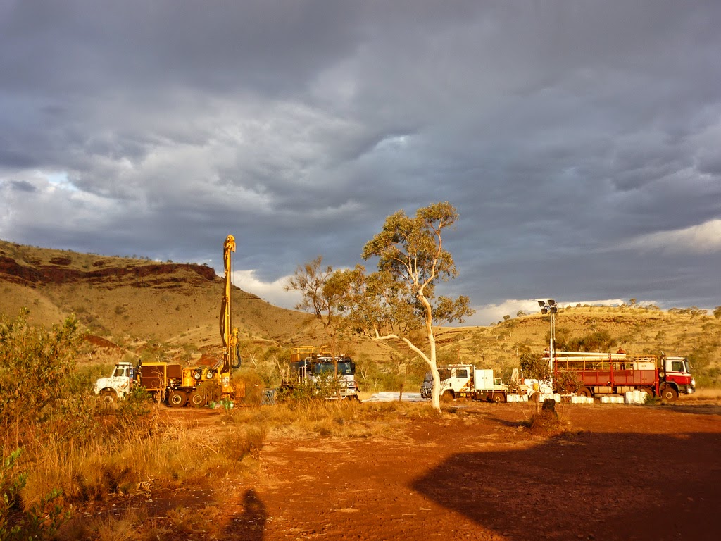
As the sonde is taken up from the bottom of the drill hole it logs the data of the surrounding rock formations. Credit: Anna Petts
Technology developed in Australia is allowing drillers to detect rock formations deep in the earth and simultaneously survey the borehole—all during the drilling process.
Drillers are then able to upload the data instantaneously to business centres for analysis. This is all done without traditionally used and expensive wire-line crews.
The technology developed by Deep Exploration Technologies Co-operative Research Centre (DET CRC) uses a shuttle or sonde and was jointly built, designed and tested by researchers at Curtin University and Perth-based company Globaltech.
Called the ‘Pathfinder Multi Shot Autonomous Sonde’ it records properties of rock formations whilst deep in the earth as well as measuring azimuth and dip of the borehole at regular intervals.
The sonde is pumped down through the drill to the bottom of a drill hole so that it protrudes beyond the drill bit. Then as the drill rods are removed, taking the sonde up too, it logs the data of the surrounding rock formations and the characteristics of the hole.
DET CRC Chief Executive Richard Hillis says this is a cost effective way of retrieving real-time data on rock formations deep in the earth.
“This may also permit the use of drilling techniques that are only half the cost of conventional diamond drilling,” he says.
During a test at the DET CRC’s Brukunga Drilling Research and Training Facility the sonde successfully recorded the natural gamma radiation in a test hole indicating that it could differentiate between rock types.
The sonde is capable of being loaded with a suite of sensors and could replace the need for drill core, saving time and analysis costs.
Current drilling technology relies on core samples being sent to laboratories for analysis, which can mean delays of weeks or months, plus the cores are destroyed in the assay process. If more data is needed, drilling crews are sent back out to the site.
Globaltech project leader Gordon Stewart says drilling crews can deploy the sonde on site.
“[Meaning] the real time information can be obtained before the drill hole collapses. Also the expense of sending separate wireline crews to run sensors down the hole can be eliminated,” he says.
The sonde is also self-powered and autonomous which means there are no power or communication wires to break—a recurring issue with traditional wireline logging tools.
This technology comes at a time when Australia’s resource and mining industry is facing rising costs coupled with declining mineral prices.
The sonde is currently being field tested in north Western Australia.
Note : The above story is based on materials provided by Science Network WA
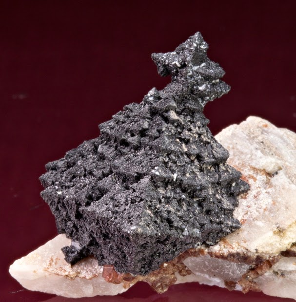
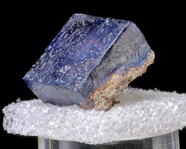
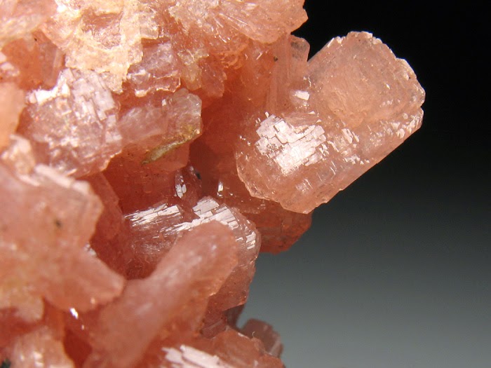
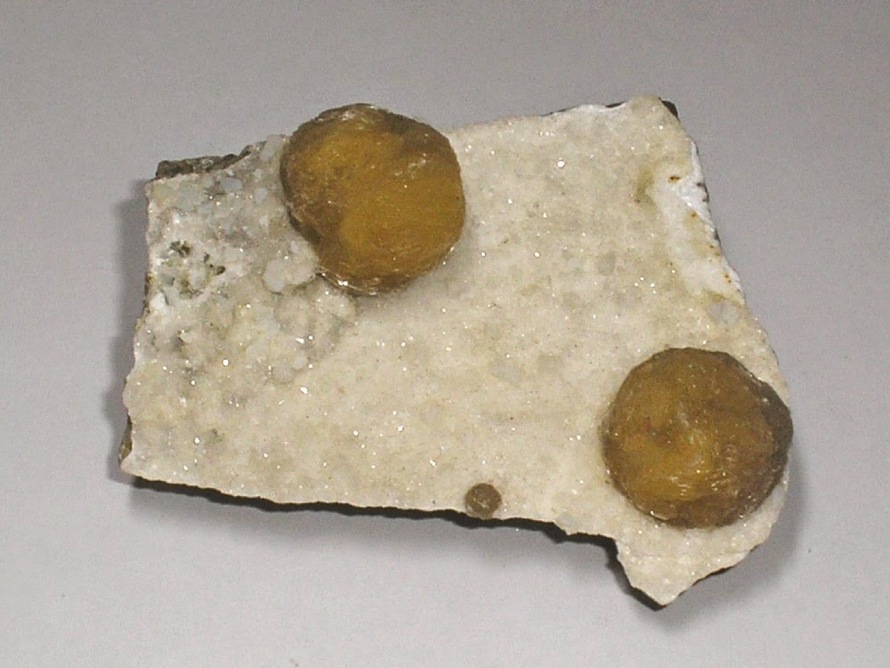
Chemical Formula: Ca2Zn(Si2O7) Locality: Franklin, Sussex Co., New Jersey, USA. Name Origin: Named for the Hardyston Township in which Franklin is situated.
Hardystonite is a rare calcium zinc silicate mineral first described from the Franklin, New Jersey, USA zinc deposits. It often contains lead, which was detrimental to the zinc smelting process, so it was not a useful ore mineral. Like many of the famous Franklin minerals, hardystonite responds to short wave ultraviolet (254 nm wavelength) light, emitting a fluorescence from dark purple to bright violet blue. In daylight, it is white to gray to light pink in color, sometimes with a vitreous or greasy luster. It is very rarely found as well formed crystals, and these are usually rectangular in appearance and rock-locked.
Hardystonite has a chemical composition of Ca2Zn(Si2O7). It is frequently found with willemite (fluoresces green), calcite (fluoresces red), and clinohedrite (fluoresces orange). Hardystonite can be found altered to clinohedrite CaZn(SiO4)·H2O through direct hydrothermal alteration. Other minerals often associated with hardystonite are franklinite, diopside, andradite garnet, and esperite (fluoresces yellow).
It was first described in 1899 by J.E. Wolff, when the New Jersey Zinc Company mines were located in what was called Franklin Furnace, in Hardyston Township, New Jersey.
Physical Properties
Cleavage: {100} Perfect, {110} Fair Color: White, Light brown, Pink. Density: 3.4 Diaphaneity: Transparent to translucent Fracture: Brittle – Generally displayed by glasses and most non-metallic minerals. Hardness: 3-4 – Calcite-Fluorite Luminescence: Fluorescent, Short UV=dark purple, Long UV=intense violet-blue. Luster: Vitreous (Glassy) Magnetism: Nonmagnetic Streak: white
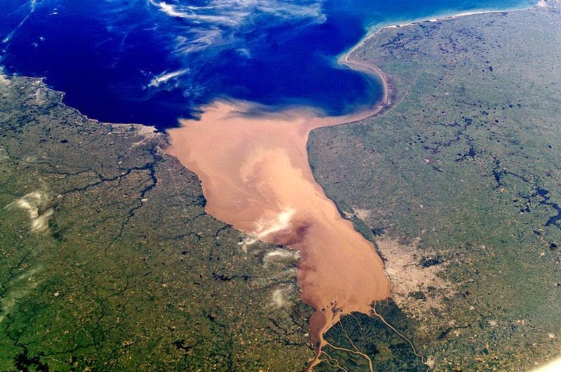
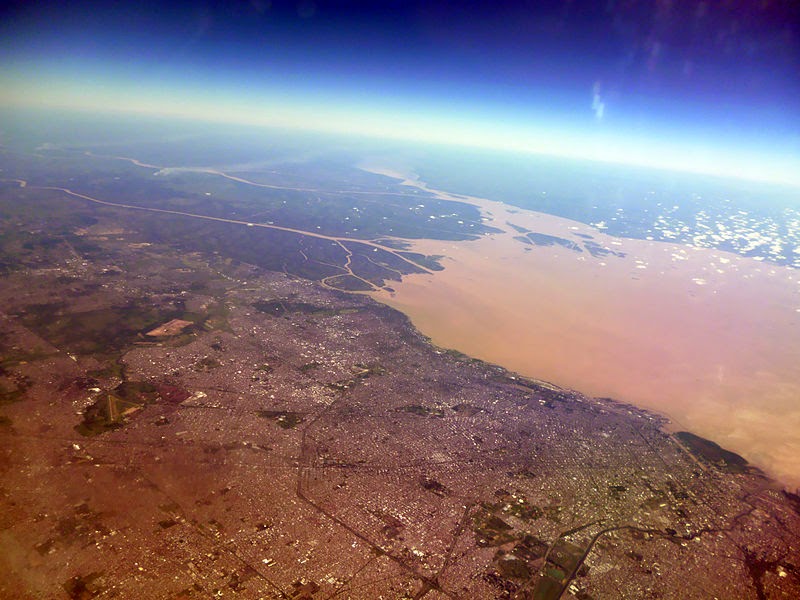
NASA photo of the Río de la Plata looking from north to south. Buenos Aires is visible on the right side near the Paraná River delta. River sediments turn the water brown to the vicinity of Montevideo, visible on the left coast.
The Río de la Plata usually rendered River Plate in British English and the Commonwealth, and occasionally rendered [La] Plata River in other English-speaking countries — is the estuary formed by the confluence of the Uruguay River and the Paraná River on the border between Argentina and Uruguay. It is a funnel-shaped indentation on the southeastern coastline of South America, about 290 kilometres (180 mi) long.
The Río de la Plata widens from about 2 kilometres (1.2 mi) at the inner part to about 220 kilometres (140 mi) at its mouth. It forms part of the border between Argentina and Uruguay, with the major ports and capital cities of Buenos Aires and Montevideo on its western and northern shores, respectively. The coasts of the Río de la Plata are the most densely populated areas of Argentina and Uruguay.
Geography
Some geographers consider the Río de la Plata a gulf or marginal sea of the Atlantic Ocean, while others consider it a river. For those who regard it to be a river it is the widest in the world, with a maximum width of about 220 kilometres (140 mi) and a total surface area of about 35,000 square kilometres (14,000 sq mi).
The Río de la Plata behaves as an estuary in which freshwater and seawater mix. Its freshwater comes from the Paraná River, one of the world’s longest, and its main tributary, the Paraguay River, as well as the Uruguay River and other smaller streams. Currents in the Río de la Plata are controlled by tides reaching to its source and beyond, into the Uruguay and Paraná rivers. Both rivers are tidally influenced for about 190 kilometres (120 mi). The tidal ranges in the Río de la Plata are small, but its large width allows for a tidal prism important enough to dominate the flow regime despite the huge discharge received by the tributary rivers. The rivers’ discharge is strong enough to prevent salt water from penetrating the inner Río de la Plata.
A submerged shoal, the Barra del Indio, acts as a barrier, dividing the Río de la Plata into an inner freshwater riverine area and an outer brackish estuarine area. The shoal is located approximately between Montevideo and Punta Piedras (the northwest end of Samborombón Bay). It is the freshwater of the inner area that causes many to describe the Río de la Plata as a river. The depth of the inner fluvial zone is between about 1 to 5 metres (3.3 to 16.4 ft). It is about 180 kilometres (110 mi) long and up to 80 kilometres (50 mi) wide. The depth of the outer estuary zone increases from 5 to 25 metres (16 to 82 ft).
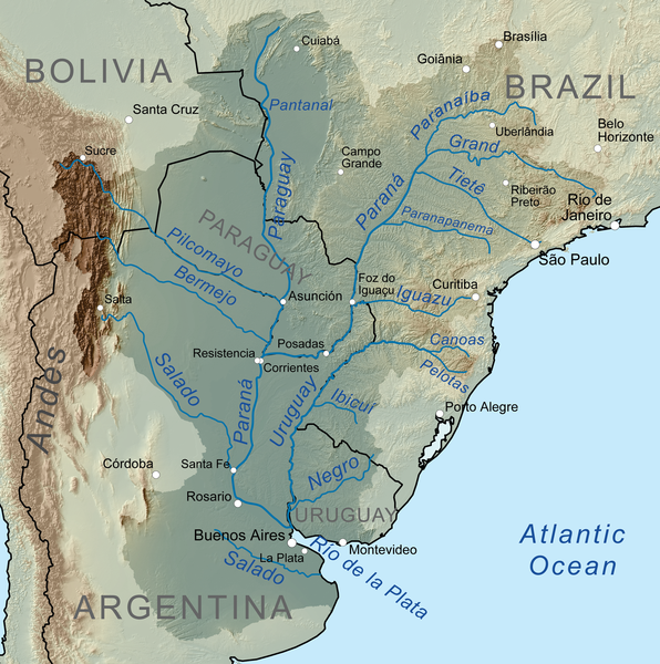
Map of the La Plata Basin, showing the Río de la Plata at the mouths of the Paraná and Uruguay rivers, near Buenos Aires.
The Río de la Plata is a salt wedge estuary. Saltwater, being denser than freshwater, penetrates into the estuary in a layer below the freshwater, which floats on the surface. Salinity fronts, or haloclines, form at the bottom and on the surface, where fresh and brackish waters meet. The salinity fronts are also pycnoclines due to the water density discontinuities. They play an important role in the reproductive processes of fish species.
Extent
The International Hydrographic Organization defines the eastern extent of the Río de la Plata as “A line joining Punta del Este, Uruguay (34°58.5′S 54°57.5′W) and Cabo San Antonio, Argentina (36°18′S 56°46′W)”.
Drainage basin
The Río de la Plata basin is the second largest drainage basin in South America. At a size of about 4,144,000 square kilometres (1,600,000 sq mi), the basin is about one fourth of the continent’s surface. It includes areas of southeastern Bolivia, southern and central Brazil, the entire nation of Paraguay, most of Uruguay, and northern Argentina. The main rivers of the La Plata basin are the Paraná, one of the longest in the world, and its main tributary, the Paraguay River, and the Uruguay River.
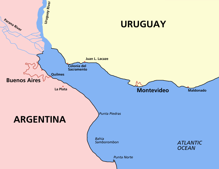
Map of the Río de la Plata, showing cities in Argentina and Uruguay.
The Paraná River’s main tributaries include the Paranaíba River, Grande River, Corumbá River, Tietê River, Paranapanema River, Iguazu River, Negro River, Carcarañá River, Gualeguay River, and the Salado River. The Paraná River ends in the large Paraná Delta.
The Paraguay’s main tributaries include the Jauru River, Cuiabá River, Taquari River, Nabileque River, Curiche Grande River, Apa River, Pilcomayo River, and the Bermejo River. The Paraguay River flows through the Pantanal wetland.
The Uruguay’s main tributaries include the Pelotas River, Canoas River, Peperiguaçu River, Ibicuí River, Quaraí River, and the Río Negro.
The rivers of the La Plata Basin carry an estimated 57,000,000 cubic metres (2.0×10⁹ cu ft) of silt into the Río de la Plata each year, where the muddy waters are stirred up by winds and tides. The shipping route from the Atlantic to Buenos Aires is kept open by constant dredging.
History
The Río de la Plata was first explored by the Portuguese in 1513. The Spanish first explored it in 1516, when the Spanish navigator Juan Díaz de Solís traversed it during his search for a passage between the Atlantic and the Pacific Oceans, naming it the Mar Dulce, or fresh water sea. The Portuguese navigator Ferdinand Magellan briefly explored the estuary in 1520 before his expedition continued its circumnavigation.
Sebastian Cabot made a detailed study of the area and renamed it Río de la Plata. He explored the Paraná and Uruguay rivers between 1526 and 1529. He ascended the Paraná as far as the present-day city of Asunción, and also explored up the Paraguay River. Trading with the Guaraní near today’s Asunción, Cabot acquired silver trinkets, and these objects gave rise to the name Río de la Plata, “river of silver”.The area was visited by Francis Drake’s fleet in early 1578, in the early stages of his circumnavigation.
The first European colony was the city of Buenos Aires, founded by Pedro de Mendoza on 2 February 1536. However, it was quickly abandoned. It was refounded by Juan de Garay on 11 June 1580. The failure to establish a settlement on the estuary led to explorations upriver and the founding of Asunción in 1537.
During the colonial era the Río de la Plata was largely neglected by the Spanish Empire until the 1760s, when Portugal and Britain threatened to expand into the estuary. The Spanish Viceroyalty of the Río de la Plata was created in 1776. In 1806 and 1807 the river was the scene of an important British invasion that aimed to occupy the area.
Conflict in the region intensified after the independence of the former Spanish and Portuguese colonies in the first quarter of the 19th century. Interests in the territories and the navigation rights over the Platine region played a major role in many armed conflicts throughout the century, including the Argentine civil wars, the Cisplatine and Platine wars, and the Paraguayan War. The river was blockaded by extra-regional powers 1838–1840 and 1845–1850.
Battle of the River Plate
In the first naval battle in the Second World War the German pocket battleship Admiral Graf Spee was engaged by the Royal Navy (RN) cruisers, HMS Exeter, Ajax and Achilles off the estuary of the River Plate. The German ship retired up the estuary with a crippled fuel system and put into port at Montevideo. A few days later, rather than fight outgunned, she was scuttled in the estuary.
Etymology
The English name “River Plate” is not, as sometimes thought, a mistranslation, as “plate” was used extensively as a noun for “silver” or “gold” from the 12th century onwards, especially in Early Modern English and the estuary has been known as the River Plate or Plate River in English since at least the time of Francis Drake. A modern translation of the Spanish Río de la Plata is “Silver River”, referring not to color but to the riches of the fabled Sierra de la Plata thought to lie upstream.
The English version of the name served as an inspiration for one of Argentina’s most important football clubs, Club Atlético River Plate.
Fauna
The Río de la Plata is a habitat for the Loggerhead Sea Turtle, Green Sea Turtle, Leatherback Sea Turtle, the rare La Plata Dolphin, and many species of fish.
Note : The above story is based on materials provided by Wikipedia
305-million-year-old fossil indicates that primitive harvestmen had extra set of eyesLiving harvestmen—a group of arachnids more commonly known as daddy longlegs—have a single pair of eyes that help them navigate habitats in every continent except Antarctica. But a newly described 305-million-year-old fossil found in eastern France shows that wasn’t always the case. New research recently published in the journal Current Biology and led by scientists at the American Museum of Natural History and the University of Manchester indicates that primitive harvestmen had two pairs of eyes, adding significant details to the evolutionary story of this diverse and highly successful group.
“Terrestrial arthropods like harvestmen have a sparse fossil record because their exoskeletons don’t preserve well,” said Prashant Sharma, a postdoctoral researcher in the Museum’s Division of Invertebrate Zoology and one of the lead authors on the new study. “As a result, some fundamental questions in the evolutionary history of these organisms remain unresolved. This exceptional fossil has given us a rare and detailed look at the anatomy of harvestmen that lived hundreds of millions of years ago.”
Despite having eight long legs and being classified as arachnids, harvestmen are not spiders, even though they resemble them. Instead, they are more closely related to scorpions among the arachnids, a group that also includes mites and ticks. Arachnids can have two kinds of eyes: lateral, those on the side of the body; and median, those near the middle of the body. The former are lacking in harvestmen species living today.
But Hastocularis argus, the new species described by the researchers from the fossil, has both median and lateral eyes. The unique fossil’s anatomy was studied in meticulous detail using high-resolution x-ray imaging at the Natural History Museum, London.
“Fossils preserved in three dimensions are quite rare,” said Russell Garwood, a research fellow at the University of Manchester and a lead author on the study. “This is especially true of harvestmen. Our x-ray techniques have allowed us to reveal this fossil in more detail than we would have dreamed possible two decades ago.”
The researchers corroborated their results by looking at the expression of a particular “eye-stalk-growing” gene in a living species of harvestmen. They found that developing embryos briefly express this gene in the lateral area, where the second eye pair is located in the fossil. But by the time they hatch, harvestmen only form the median eyes.
Note : The above story is based on materials provided by American Museum of Natural History
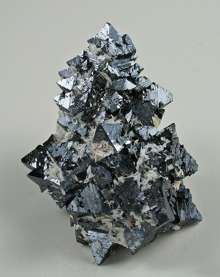
Hanksite – Giant Crystal from TYPE LOC. Searles Lake, near Trona, San Bernardino Co., California, USA Large Cabinet, 18.2 x 15.9 x 12.3 cm “Courtesy of Rob Lavinsky, The Arkenstone, www.iRocks.com”
Chemical Formula: Na22K(SO4)9(CO3)2Cl Locality: Searles Lake, San Bernardino Co. California. Name Origin: Named for H. G. Hanks, American geologist.
Hanksite is a sulfate mineral, distinguished as one of only a handful that contain both carbonate and sulfate ion groups. It has the chemical formula: Na22K(SO4)9(CO3)2Cl.
Occurrence
It was first described in 1888 for an occurrence in Searles Lake, California and named for American geologist Henry Garber Hanks (1826–1907). Hanksite is normally found in crystal form as evaporite deposits. Hanksite crystals are large but not complex in structure. It is often found in Searles Lake, Soda Lake, Mono Lake, and in Death Valley. It is associated with halite, borax, trona and aphthitalite in the Searles Lake area.
Physical Properties
Cleavage: {0001} Good Color: Colorless, Gray, Grayish black, Yellow, Yellowish white. Density: 2.5 Diaphaneity: Transparent Fracture: Conchoidal – Fractures developed in brittle materials characterized by smoothly curving surfaces, (e.g. quartz). Hardness: 3 – Calcite Luminescence: Fluorescent, Long UV=weak yellow. Luster: Vitreous – Greasy Magnetism: Nonmagnetic Streak: white
Photos :
Hanksite Searles Lake, San Bernardino County, California, USA Small Cabinet, 7.8 x 5.4 x 5.4 cm “Courtesy of Rob Lavinsky, The Arkenstone, www.iRocks.com”Hanksite (TYPE LOC.) Searles Lake, near Trona, San Bernardino Co., California, USA Small Cabinet, 9.7 x 7.4 x 7.2 cm “Courtesy of Rob Lavinsky, The Arkenstone, www.iRocks.com”Hanksite Searles Lake, San Bernardino County, California, USA Large Cabinet, 16.3 x 13.8 x 7.4 cm “Courtesy of Rob Lavinsky, The Arkenstone, www.iRocks.com”
Drill core sample of a 2.55 billion-year-old organic-rich marine mudrock from South Africa, with isolated pyrite nodules and thin laminae (gold). South African one-rand coin shown for scale. Credit: W. Fischer/Caltech
A lot can happen to a rock over the course of two and a half billion years. It can get buried and heated; fluids remove some of its minerals and precipitate others; its chemistry changes. So if you want to use that rock to learn about the conditions on the early Earth, you have to do some geologic sleuthing: You have to figure out which parts of the rock are original and which came later. That is a tricky task, but now a team of Caltech researchers has developed and applied a unique technique that removes much of the guesswork.
“We want to know what Earth looked like when these ancient rocks were deposited. That’s a giant challenge because a number of processes have scrambled and erased the original history,” says Woodward Fischer, an assistant professor of geobiology at Caltech. “This is a first big effort to try to wrestle with that.”
Fischer is the lead author on a paper that describes the new technique and findings in the current issue of the Proceedings of the National Academy of Sciences.
Using the new method, Fischer and his colleagues have examined ancient rocks dating to an age before the rise of oxygen. Today, water feeds the biosphere, providing the electrons needed to support life. But before the evolution of photosynthesis and the accumulation of oxygen in the atmosphere, elements such as iron and sulfur were the source of electrons. Researchers interested in the early Earth would like to determine how and when life figured out how to use these elements. The Caltech team has identified clear evidence that 2.5 billion years ago, sulfate-reducing microbes were already at work.
The researchers studied drill core samples collected in South Africa from sedimentary rocks that are slightly older than 2.5 billion years old. They focused on small features within the rocks, called nodules, made of the mineral pyrite. Also known as fool’s gold, pyrite can be made in a number of ways, including as a product of respiratory metabolism: sulfate-reducing microbes reduce sulfate, which is present in seawater, yielding hydrogen sulfide, and when that hydrogen sulfide mingles with iron, pyrite is produced.
Today, sulfate-reducing microbes are often found in anoxic environments such as marine sediments where the oxygen has been consumed by aerobes but where there is still plenty of organic matter. It is logical, then, to suspect that these microbes would have been important players on the early Earth, when oxygen was scarce. Comparative genomics studies of sulfate reducers that are living today also suggest that these microbes should have been present 2.5 billion years ago. But this has been difficult to confirm in the rock record.
From current studies, scientists know that sulfate reducers metabolize the various stable isotopes of sulfur in a predictable way: producing light sulfur isotopes first before moving on to produce heavier ones as they run out of substrate. This provides a chemical thumbprint that researchers can look for as they examine pyrite nodules. The nodules crystalize early within the sediments, with the material at their core forming before the material at their edges. Therefore, to check whether sulfur-reducing organisms were active when a particular pyrite-containing rock formed, a geobiologist should be able to measure the ratios of a nodule’s sulfur isotopes at different points—both near the core and closer to the edges—to see how those ratios changed as the nodule grew. But the nodules are only about a millimeter in diameter, so researchers have not been able to collect the fine-grained measurements they need in order to identify the isotopic thumbprint. Instead, they often grind up an entire rock sample, measure its isotopic composition, and then compare it to another rock.
Muddying the interpretation even more, these ancient rocks have all been deeply complicated by the wrinkles of time. All of the events and circumstances that have affected them since their deposition have left their chemical marks, by carving away old materials and precipitating new ones. A geologist can use some of the textures—the marks left in the fabric of the rock—to unravel some of a rock’s history, but only if those textures clearly crosscut or overlap one another. Some of the visual cues can also be misleading. So it can be difficult just to identify which parts of a rock are original and can therefore provide insight about the early Earth.
Fischer’s new technique changes all that. It allows researchers to untangle a rock’s history and to then zoom in and measure the isotopic ratios at a number of points within a single pyrite nodule.
He begins as any geologist would—by looking at a sample with light and electron microscopy to identify the different textures within the rock. Doing that, he might identify a number of pyrite nodules that “look good”—that appear to date to the rock’s original deposition.
He then uses a technique called scanning SQUID (superconducting quantum interference device) microscopy, which uses a quantum detector to produce a magnetic map of the sample at a very small scale. Pyrite itself is not magnetic, but when it is later altered, it forms a mineral called pyrrhotite, which is magnetic. Using scanning SQUID microscopy, Fischer has been able to rule out a number of nodules that had appeared to be original but that were in fact magnetic, meaning that they included pyrrhotite. In his South African samples, those deceptive features dated to a volcanic event 500 million years after the rocks were deposited, which sent chemistry-altering fluids through all the layers of sediment and rock that were present at the time.
“If you weren’t using this technique, you’d miss the later alteration,” Fischer says. “Those textures looked good. They would have passed naive tests.”
The final step in the process is to measure the isotopic composition of the nodules using an analytical method called secondary ion mass spectrometry (SIMS). This specialized technique is used to measure the chemistry of thin films and solids with very fine spatial resolution. Materials scientists use it to analyze silicon wafers, for example, and planetary scientists have used it to study bits of rock from the moon. Fischer’s group is one of the few in the world that uses it to study ancient rocks.
In SIMS, a sample under very strong vacuum is bombarded with a beam of cesium ions, which displaces ions from the surface of the sample. A mass spectrometer can measure those so-called secondary ions, providing a count of the sample’s sulfur isotopes. Since the beam can be focused very precisely, the method allows researchers to sample many points within a single nodule, measuring a 13 x 5 grid within a millimeter, for example. The product is essentially a map of the sample’s isotopic composition.
“It’s one thing to say, ‘Wow, rocks are really complicated. There’s just going to be information lost.’ It’s another thing to be able to go back in and say, ‘I know how to piece together the history of this rock and learn something about the early Earth that I didn’t know previously.'”
Using the new technique, Fischer and his colleagues were able to identify which parts of their drill core samples were truly ancient and to then measure the sulfur isotopic composition of those nodules as they grew. And indeed they found the isotopic signature expected as a result of the activity of sulfur-reducing microbes.
“This work supports the hypothesis that microbial sulfate reduction was an important metabolism in organic-rich environments on the early Earth,” Fischer says. “What’s more, we now know how we can ask better questions about ancient rocks. That, for me, is incredibly exciting.”
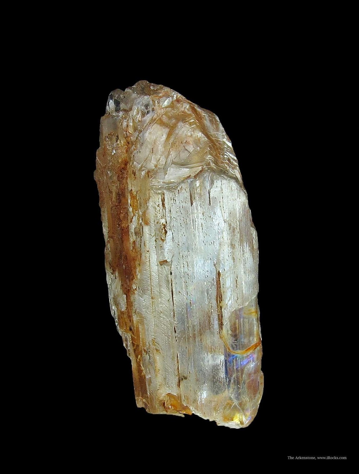
Chemical Formula: Be2(BO3)(OH) Locality: Helgeroa, Langesundsfjord, Norway. Name Origin: Named for Axel Hamberg (1863-1933), Swedish mineralogist and geographer.
Hambergite (Be2(BO3)(OH)) is a beryllium borate mineral named after Swedish explorer and mineralogist Axel Hamberg (1863–1933). The mineral occurs as white or colorless orthorhombic crystals.
Occurrence
Hambergite occurs in beryllium bearing granite pegmatites as a rare accessory phase. It occurs associated with beryl, danburite, apatite, spodumene, zircon, fluorite, feldspar and quartz.
It was first described by mineralogist and geographer W. C. Brøgger in 1890. The type locality is Salbutangen, Helgeroa, Langesundsfjorden, Larvik, Vestfold, Norway where it was found in a pegmatite dike of nepheline syenite composition.
Physical Properties
Cleavage: {010} Perfect, {100} Good Color: Colorless, Gray white, Yellowish white, White. Density: 2.372 Diaphaneity: Transparent to Translucent Fracture: Brittle – Generally displayed by glasses and most non-metallic minerals. Hardness: 7.5 – Garnet Luminescence: Non-fluorescent. Luster: Vitreous – Dull Streak: white
The expansion of the Antarctic ice shield 14 million years ago was followed by a warming of the Southern ocean’s surface temperature. Credit: Frank Roedel, Alfred-Wegener-Institut
Scientists of the Alfred Wegener Institute, Helmholtz Centre for Polar and Marine Research (AWI), have deciphered a supposed climate paradox from the Miocene era by means of complex model simulations. When the Antarctic ice sheet grew to its present-day size around 14 million years ago, it did not get colder everywhere on Earth, but there were regions that became warmer. A physical contradiction? No, as AWI experts now found out, the expansion of the ice sheet on the Antarctic continent triggered changes in winds, ocean currents and sea ice in the Southern Ocean that in the end led to the apparently contrary developments. The scientists report this in a new study published online in the journal Nature Geoscience.
From a geological perspective, the ice sheet of Antarctica is still relatively young. As climate researchers know from sediment samples and calcareous Foraminifera shells, the ice sheet grew to its present-day size around 14 million years ago. At the same time the surface temperature of the Southern Ocean rose by up to three degrees Celsius back then — a seemingly contradictory development, for which climate scientists had no logical explanation for a long time.
“If you imagine that the Antarctic ice sheet grew to its present size in a period of 100,000 years, it seems reasonable to suppose that self-reinforcing climate processes set in during this growth period and further boosted the cooling effect. One could assume, for instance, that the expanding ice sheet reflected more and more solar energy into space, as a result of which the air over the continent became colder and strong offshore winds swept over the ocean, cooled the water and created a huge amount of sea ice. Our climate data, however, paint a different picture,” says AWI climate researcher Dr. Gregor Knorr.
He and his AWI colleague Prof. Dr. Gerrit Lohmann succeeded in depicting the climate conditions at that time in a coupled atmosphere-ocean model and in this way examined what changes the formation of the Antarctic ice sheet triggered in the climate system.
“Our simulation results show that the air temperature over the continent actually decreased by up to 22 degrees Celsius when the ice sheet grew, which led to cooling in some regions of the Southern Ocean. At the same time, however, the surface temperature in the Weddell Sea rose by up to six degrees Celsius,” says Gregor Knorr.
The AWI climate scientists looked for the causes of these contrary changes in their model experiments and found them in the wind. “The expansion of the Antarctic ice sheet led to changes in the wind patterns over the Weddell Sea, for example. As a consequence, there was a shift in the flow of warm water towards the pole and the sea ice in this marine region declined,” explains the AWI climate modeller.
These changes on the surface of the ocean brought about further changes in deep water, which in turn boosted the temperature rise in the surface water in a way unknown to the researchers up to now.
“Our model calculations helped us to develop a new understanding of Earth system processes back then. Today we can explain what influence the formation of the Antarctic ice sheet had on temperature curves in the Southern Ocean of that time and how the recorded climate changes came about in marine sediment cores,” says Gregor Knorr.
At the same time a great challenge arises for climate scientists as a consequence of these new insights. “On the one hand, our results show that we can understand climate processes by means of models to interpret data from climate history. On the other hand, the results also confirm that feedback mechanisms between individual climate factors are substantially more complex than we had previously assumed,” says Gerrit Lohmann.
Can these new model calculations and insights be used for forecasts regarding current climate change? Gregor Knorr: “No, not directly. Models used to simulate climate change scenarios for the coming 100 years have a much finer resolution and ice sheet changes are not taken into account. For us it was important to gain a better understanding of how the climate system reacts to dramatic changes over a period of 100,000 years and more. Nevertheless, we cannot rule out that similar mechanisms might also play a role for climate changes in the distant future.”
Note : The above story is based on materials provided by Alfred Wegener Institute, Helmholtz Centre for Polar and Marine Research.
Known as the “Roof of the World,” the Tibetan Plateau covers more than 970,000 square miles in Asia and India and reaches heights of over 15,000 feet. Hoke’s discovery not only makes the plateau larger than previously thought, but also suggests that some of the topography is millions of years younger. Credit: Image courtesy of Syracuse University
Earth scientists in Syracuse University’s College of Arts and Sciences have determined that the Tibetan Plateau — the world’s largest, highest, and flattest plateau — had a larger initial extent than previously documented.
Their discovery is the subject of an article in the journal Earth and Planetary Science Letters (Elsevier, 2014).
Gregory Hoke, assistant professor of Earth sciences, and Gregory Wissink, a Ph.D. student in his lab, have co-authored the article with Jing Liu-Zeng, director of the Division of Neotectonics and Geomorphology at the Institute for Geology, part of the China Earthquake Administration; Michael Hren, assistant professor of chemistry at the University of Connecticut; and Carmala Garzione, professor and chair of Earth and environmental sciences at the University of Rochester.
“We’ve determined the elevation history of the southeast margin of the Tibetan Plateau,” says Hoke, who specializes in the interplay between Earth’s tectonic and surface processes. “By the Eocene epoch (approximately 40 million years ago), the southern part of the plateau extended some 600 miles more to the east than previously documented. This discovery upends a popular model for plateau formation.”
Known as the “Roof of the World,” the Tibetan Plateau covers more than 970,000 square miles in Asia and India and reaches heights of over 15,000 feet. The plateau also contains a host of natural resources, including large mineral deposits and tens of thousands of glaciers, and is the headwaters of many major drainage basins.
Hoke says he was attracted to the topography of the plateau’s southeast margin because it presented an opportunity to use information from minerals formed at Earth’s surface to infer what happened below them in the crust.
“The tectonic and topographic evolution of the southeast margin has been the subject of considerable controversy,” he says. “Our study provides the first quantitative estimate of the past elevation of the eastern portions of the plateau.”
Historically, geologists have thought that lower crustal flow — a process by which hot, ductile rock material flows from high- to low-pressure zones — helped elevate parts of the plateau about 20 million years ago. (This uplift model has also been used to explain watershed reorganization among some of the world’s largest rivers, including the Yangtze in China.)
But years of studying rock and water samples from the plateau have led Hoke to rethink the area’s history. For starters, his data indicates that the plateau has been at or near its present elevation since the Eocene epoch. Moreover, surface uplift in the southernmost part of the plateau — in and around southern China and northern Vietnam — has been historically small.
“Surface uplift, caused by lower crustal flow, doesn’t explain the evolution of regional river networks,” says Hoke, referring to the process by which a river drainage system is diverted, or captured, from its own bed into that of a neighboring bed. “Our study suggests that river capture and drainage reorganization must have been the result of a slip on the major faults bounding the southeast plateau margin.”
Hoke’s discovery not only makes the plateau larger than previously thought, but also suggests that some of the topography is millions of years younger.
“Our data provides the first direct documentation of the magnitude and geographic extent of elevation change on the southeast margin of the Tibetan Plateau, tens of millions years ago,” Hoke adds. “Constraining the age, spatial extent, and magnitude of ancient topography has a profound effect on how we understand the construction of mountain ranges and high plateaus, such as those in Tibet and the Altiplano region in Bolivia.”
Note : The above story is based on materials provided by Syracuse University.
Benca described this 400-million-year-old fossil lycopod, Leclercqia scolopendra, and created a life-like computer rendering. The stem of the lycopod is about 2.5 millimeters across. Credit: Image courtesy of University of California – Berkeley
Jeff Benca is an admitted über-geek when it comes to prehistoric plants, so it was no surprise that, when he submitted a paper describing a new species of long-extinct lycopod for publication, he ditched the standard line drawing and insisted on a detailed and beautifully rendered color reconstruction of the plant. This piece earned the cover of March’s centennial issue of the American Journal of Botany.
Benca described this 400-million-year-old fossil lycopod, Leclercqia scolopendra, and created a life-like computer rendering. The stem of the lycopod is about 2.5 millimeters across.
“Typically, when you see pictures of early land plants, they’re not that sexy: there is a green forking stick and that’s about it. We don’t have many thorough reconstructions,” said Benca, a graduate student in the Department of Integrative Biology and Museum of Paleontology at UC Berkeley. “I wanted to give an impression of what they may have really looked like. There are great color reconstructions of dinosaurs, so why not a plant?”
Benca’s realistic, full-color image could be a life portrait, except for the fact that it was drawn from a plant that lay flattened and compressed into rock for more than 375 million years.
Called Leclercqia scolopendra, or centipede clubmoss, the plant lived during the “age of fishes,” the Devonian Period. At that time, lycopods — the group Leclercqia belonged to — were one of few plant lineages with leaves. Leclercqia shoots were about a quarter-inch in diameter and probably formed prickly, scrambling, ground-covering mats. The function of Leclercqia’s hook-like leaf tips is unclear, Benca said, but they may have been used to clamber over larger plants. Today, lycopods are represented by a group of inconspicuous plants called club mosses, quillworts and spikemosses.
Both living and extinct lycopods have fascinated Benca since high school. When he came to UC Berkeley last year from the University of Washington, he brought a truckload of some 70 different species, now part of collections at the UC Botanical Garden.
Now working in the paleobotany lab of Cindy Looy, Berkeley assistant professor of integrative biology, Benca continues to establish a growing list of living lycopod species, several of which will eventually be incorporated into the UC and Jepson Herbaria collections.
Visualizing plant evolution
Benca and colleagues wrote their paper primarily to demonstrate a new technique that is helping paleobotanists interpret early land plant fossils with greater confidence. Since living clubmosses share many traits with early lycopods, the research team was able to test their methods using living relatives Benca was growing in greenhouses.Early land plant fossils are not easy to come by, but they can be abundant in places where rocks from the Devonian Period form outcrops. But a large portion of these are just stem fragments with few diagnostic features to distinguish them, Benca said.
“The way we analyzed Leclercqia material makes it possible to gain more information from these fragments, increasing our sample size of discernible fossils,” he said.
“Getting a better grip on just how diverse and variable Devonian plants were will be important to understanding the origins of key traits we see in so many plants today.” Looy said. Benca’s co-authors are Maureen H. Carlisle, Silas Bergen and Caroline A. E. Strömberg from the University of Washington and Burke Museum of Natural History and Culture, Seattle.
Note : The above story is based on materials provided by University of California – Berkeley.
Chemical Formula: NaCl Locality: World wide in sedimentary basins. Name Origin: From the Greek halos, meaning “salt” and lithos meaning “rock.”
Halite commonly known as rock salt, is the mineral form of sodium chloride (NaCl). Halite forms isometric crystals. The mineral is typically colorless or white, but may also be light blue, dark blue, purple, pink, red, orange, yellow or grey depending on the amount and type of impurities. It commonly occurs with other evaporite deposit minerals such as several of the sulfates, halides, and borates.
Occurrence
Halite occurs in vast beds of sedimentary evaporite minerals that result from the drying up of enclosed lakes, playas, and seas. Salt beds may be hundreds of meters thick and underlie broad areas. In the United States and Canada extensive underground beds extend from the Appalachian basin of western New York through parts of Ontario and under much of the Michigan Basin. Other deposits are in Ohio, Kansas, New Mexico, Nova Scotia and Saskatchewan. The Khewra salt mine is a massive deposit of halite near Islamabad, Pakistan. In the United Kingdom there are three mines; the largest of these is at Winsford in Cheshire producing half a million tonnes on average in six months.
Salt domes are vertical diapirs or pipe-like masses of salt that have been essentially “squeezed up” from underlying salt beds by mobilization due to the weight of overlying rock. Salt domes contain anhydrite, gypsum, and native sulfur, in addition to halite and sylvite. They are common along the Gulf coasts of Texas and Louisiana and are often associated with petroleum deposits. Germany, Spain, the Netherlands, Romania and Iran also have salt domes. Salt glaciers exist in arid Iran where the salt has broken through the surface at high elevation and flows downhill. In all of these cases, halite is said to be behaving in the manner of a rheid.
Physical Properties
Cleavage: {100} Perfect, {010} Perfect, {001} Perfect Color: White, Clear, Light blue, Dark blue, Pink. Density: 2.17 Diaphaneity: Transparent Fracture: Brittle – Generally displayed by glasses and most non-metallic minerals. Hardness: 2.5 – Finger Nail Luminescence: Fluorescent, Short UV=red, green (organic inclusions) orange, Long UV=red, green orange. Luster: Vitreous (Glassy) Magnetism: Nonmagnetic Streak: white
Cambrian embryo fossil exposed by acid etching on rock surface. Polygonal structure on surface indicative of blastula-stage of development. Credit: Broce et al.
The Cambrian Period is a time when most phyla of marine invertebrates first appeared in the fossil record. Also dubbed the “Cambrian explosion,” fossilized records from this time provide glimpses into evolutionary biology when the world’s ecosystems rapidly changed and diversified. Most fossils show the organisms’ skeletal structure, which may or may not give researchers accurate pictures of these prehistoric organisms. Now, researchers at the University of Missouri have found rare, fossilized embryos they believe were undiscovered previously. Their methods of study may help with future interpretation of evolutionary history.
“Before the Ediacaran and Cambrian Periods, organisms were unicellular and simple,” said James Schiffbauer, assistant professor of geological sciences in the MU College of Arts and Science. “The Cambrian Period, which occurred between 540 million and 485 million years ago, ushered in the advent of shells. Over time, shells and exoskeletons can be fossilized, giving scientists clues into how organisms existed millions of years ago. This adaptation provided protection and structural integrity for organisms. My work focuses on those harder-to-find, soft-tissue organisms that weren’t preserved quite as easily and aren’t quite as plentiful.”
Schiffbauer and his team, including Jesse Broce, a Huggins Scholar doctoral student in the Department of Geological Sciences at MU, now are studying fossilized embryos in rocks that provide rare opportunities to study the origins and developmental biology of early animals during the Cambrian explosion.
Broce collected fossils from the lower Cambrian Shuijingtuo Formation in the Hubei Province of South China and analyzed samples to determine the chemical makeup of the rocks. Soft tissue fossils have different chemical patterns than harder, skeletal remains, helping researchers identify the processes that contributed to their preservation. It is important to understand how the fossils were preserved, because their chemical makeups can also offer clues about the nature of the organisms’ original tissues, Schiffbauer said.
“Something obviously went wrong in these fossils,” Schiffbauer said. “Our Earth has a pretty good way of cleaning up after things die. Here, the cells’ self-destructive mechanisms didn’t happen, and these soft tissues could be preserved. While studying the fossils we collected, we found over 140 spherically shaped fossils, some of which include features that are reminiscent of division stage embryos, essentially frozen in time.”
The fossilized embryos the researchers found were significantly smaller than other fossil embryos from the same time period, suggesting they represent a yet undescribed organism. Additional research will focus on identifying the parents of these embryos, and their evolutionary position.
Schiffbauer and his colleagues published this and related research in a volume of the Journal of Paleontology which he co-edited.
The world’s reefs are hotbeds of biological diversity, including over 4,500 species of fish. A new study shows that the ancestors of these fish colonized reefs in two distinct waves, before and after the mass extinction event about 66 million years ago that wiped out the dinosaurs.
Reef fish represent one of the largest and most diverse assemblages of vertebrates, according to Samantha Price, a postdoctoral researcher in the Department of Evolution and Ecology at UC Davis. Price is first author on a paper describing the work, published April 2 in the journal Proceedings of the Royal Society B.
The fossil record of reef fish is patchy, so Price and colleagues traced their ancestry by developing a comprehensive family tree of the major group of modern ocean fish, the acanthomorphs or “spiny-finned fish,” and calculating the times when different groups migrated into or out of reef habitats.
The first wave of colonization occurred between 70 and 90 million years ago, before the end of the Cretaceous period, they found. At that time, most the world’s reefs were built not by coral but by mollusks called rudists.
Rudists disappeared in the mass extinction at the end of the Cretaceous, 66 million years ago, and corals became the world’s great reef builders. While the first-wave reef fish hung on to leave descendants in the present, a second wave of colonization took place as the world recovered from the extinction event.
The early wave of colonization began with lots of different-looking fish and over time there was an eventual filling of ecological niches accompanied by a decrease in colonization, Price said.
By about 50 million years ago, the fundamentals of modern coral reefs, including the ancestors of most major families, such as clownfishes and parrotfishes, were in place, Price said.
“If you were able to dive on a coral reef 50 million years ago, the fishes would seem familiar, you would recognize it as similar to a modern reef,” she said.
Note : The above story is based on materials provided by University of California – Davis.
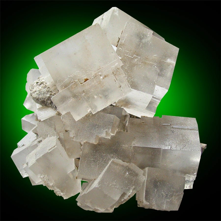
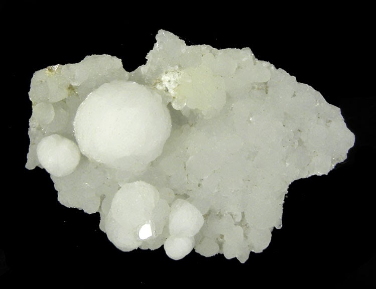
Chemical Formula: NaCa16Si23AlO60(OH)8·14H2O Locality: Isle of Skye, Scotland, UK. Name Origin: From the Greek guros = “circle”, in allusion to the round form of the crystalline groupings.
Gyrolite often forms nodular aggregates. These aggregates can appear glassy, dull or even fiberous. Unlike other similar looking minerals (such as prehnite or smithsonite), gyrolite usually forms individual nodules as opposed to botryoidal or crustal growths. The aggregate nodules can often accompany many fine and rare minerals such as apophyllite, okenite and many of the zeolites. Much gyrolite forms inside of volcanic bubbles called vesicles and can only add another element to the surreal “landscape” inside.
Physical Properties
Color: Brown, Colorless, Yellow, White, Light green. Density: 2.45 – 2.51, Average = 2.48 Diaphaneity: Transparent to translucent Fracture: Brittle – Uneven – Very brittle fracture producing uneven fragments. Hardness: 2.5 – Finger Nail Luminescence: Fluorescent, Short UV=white, Long UV=white. Luster: Vitreous (Glassy) Magnetism: Nonmagnetic Streak: white
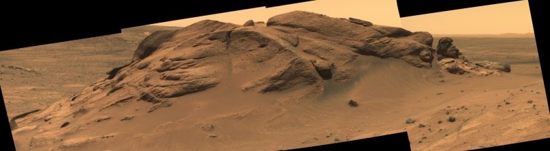
Comanche outcrop, seen in a mosaic of panoramic camera images from Mars rover Spirit, holds key mineralogical evidence for an ancient lake in Gusev Crater. Credit: NASA/JPL-Caltech/Cornell University/Arizona State University
If desert mirages occur on Mars, “Lake Gusev” belongs among them. This come-and-go body of ancient water has come and gone more than once, at least in the eyes of Mars scientists.
Now, however, it’s finally shifting into sharper focus, thanks to a new analysis of old data by a team led by Steve Ruff, associate research professor at Arizona State University’s Mars Space Flight Facility in the School of Earth and Space Exploration. The team’s report was just published in the April 2014 issue of the journal Geology.
The story begins in early 2004, when NASA landed Spirit, one of its two Mars Exploration Rovers, inside 100-mile-wide Gusev Crater. Why Gusev? Because from orbit, Gusev, with its southern rim breached by a meandering river channel, looked as if it once held a lake — and water-deposited rocks were the rover mission’s focus. Yet, when Spirit began to explore, scientists found Gusev’s floor was paved not with lakebed sediments, but volcanic rocks.
Less than two miles away however, stood the Columbia Hills, 300 feet high. When Spirit drove up into them, it indeed discovered ancient rocks that had been altered by water. But to scientists’ chagrin, no lake sediments were among them. Instead, scientists discovered evidence of hydrothermal activity — essentially hot springs like those in Yellowstone National Park.
But there’s hope yet for Lake Gusev, thanks to a Columbia Hills rock outcrop, dubbed Comanche. This outcrop is unusually rich in magnesium-iron carbonate minerals, a discovery made in 2010 that Ruff played a major role in. While Comanche’s carbonate minerals were originally attributed to hydrothermal activity, the team’s new analysis points to a different origin.
Cool waters
Says Ruff, “We looked more closely at the composition and geologic setting of Comanche and nearby outcrops. There’s good evidence that low temperature surface waters introduced the carbonates into Comanche rather than hot water rising from deep down.”
Comanche started out as a volcanic ash deposit known as tephra that originally covered the Columbia Hills and adjacent plains. This material, Ruff explains, came from explosive eruptions somewhere within or around Gusev.
Then floodwaters entered the crater through the huge valley that breaches Gusev’s southern rim. These floods appear to have ponded long enough to alter the tephra, producing briny solutions. When the brines evaporated, they left behind residues of carbonate minerals. As the lake filled and dried, perhaps many times in succession, it loaded Comanche and its neighbor rocks with carbonates.
“The lake didn’t have to be big,” Ruff explains. “The Columbia Hills stand 300 feet high, but they’re in the lowest part of Gusev. So a deep, crater-spanning lake wasn’t needed.”
Today, the Columbia Hills rise as an island of older terrain surrounded by younger lava flows, Ruff says. “Comanche and a neighbor outcrop called Algonquin are remnants of the older and much more widespread tephra deposit. The wind has eroded most of that deposit, also carrying away much of the evidence for an ancient lake.”
Return to Gusev?
Mars rover Spirit fell silent on a winter night in March 2010, and it has never been heard from since. Spirit left most of the Columbia Hills and other Gusev targets unexplored. Ruff says that as NASA evaluates landing sites for its new sample-collecting rover in 2020, Gusev Crater deserves serious consideration.
“Going back to Gusev would give us an opportunity for a second field season there, which any terrestrial geologist would understand,” argues Ruff. “After the first field season with Spirit, we now have a bunch more questions and new hypotheses that can be addressed by going back.”
Because the Mars 2020 rover mission will collect and cache samples for potential return to Earth, that makes going to an already visited site more important, says Ruff.
“Scientifically and operationally it makes sense to go to a place which we know has geologically diverse — and astrobiologically interesting — materials to sample,” Ruff argues.
“And we know exactly where to find them.”
Note : The above story is based on materials provided by Arizona State University.