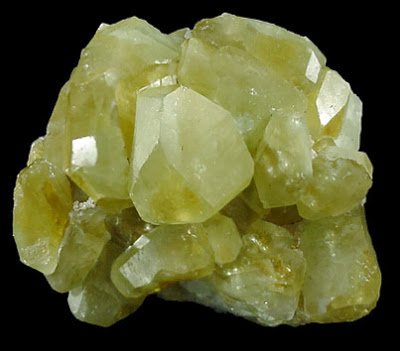
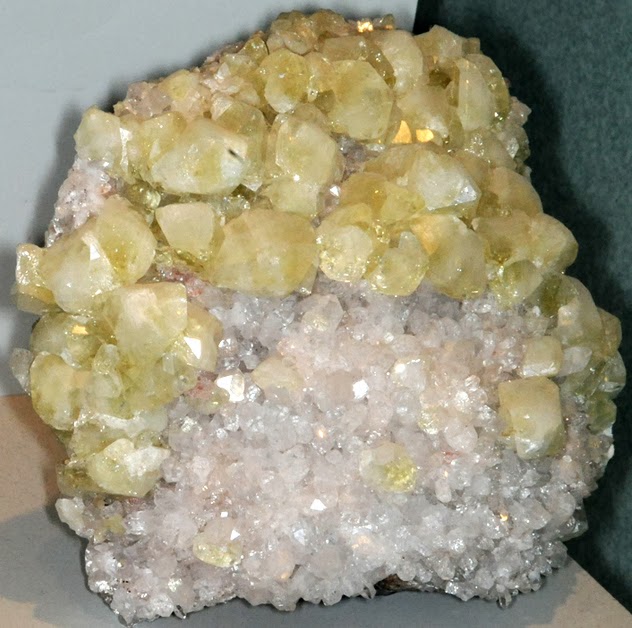
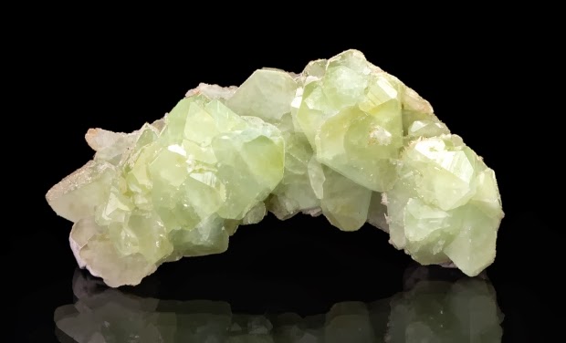
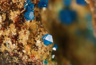
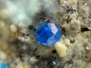
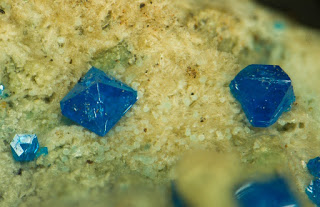
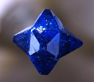
Chemical Formula: Ca(HBSiO5) Locality: Diabases of the Connecticut River valley, USA. Name Origin: From the Greek, dateisthai, meaning “to divide,” because granular aggregates crumble readily.
Datolite is a calcium boron hydroxide nesosilicate, Ca(HBSiO5). It was first observed by Jens Esmark in 1806, and named by him from δατεῖσθαι, “to divide,” and λίθος, “stone,” in allusion to the granular structure of the massive mineral.
Datolite crystallizes in the monoclinic system forming prismatic crystals and nodular masses. The luster is vitreous and may be brown, yellow, light green or colorless. The Mohs hardness is 5.5 and the specific gravity is 2.8 – 3.0.
The type localities are in the diabases of the Connecticut River valley and Arendal, Aust-Agder, Norway. Associated minerals include prehnite, danburite, babingtonite, epidote, native copper, calcite, quartz and zeolites. It is common in the copper deposits of the Lake Superior region of Michigan. It occurs as a secondary mineral in mafic igneous rocks often filling vesicles along with zeolites in basalt. Unlike most localities throughout the world, the occurrence of datolite in the Lake Superior region is usually fine grained in texture and possesses colored banding. Much of the coloration is due to the inclusion of copper or associated minerals in progressive stages of hydrothermal precipitation.
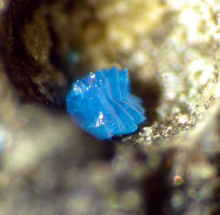
Botryolite is a botryoidal form of datolite.
Physical Properties of Datolite
Cleavage: None Color: Brown, Colorless, Yellow, White, Light green. Density: 2.8 – 3, Average = 2.9 Diaphaneity: Transparent to translucent Fracture: Brittle – Generally displayed by glasses and most non-metallic minerals. Hardness: 5.5 – Knife Blade Luminescence: Non-fluorescent. Luster: Vitreous (Glassy) Streak: white
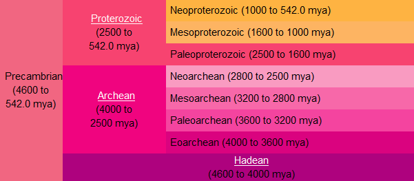
In the geologic record the Eoarchean (/ˌiːoʊ.ɑrˈkiːən/; also spelled Eoarchaean) Era or erathem is the earliest time following the solidification of Earth’s crust. It follows the Hadean and precedes the Paleoarchean Era of the geologic timescale. The approximate abiotic origins of life (abiogenesis) have been dated to a time window from 4,000 to 3,600 million years ago when atmospheric pressure values ranged from ca. 100 to 10 bar.
Chronology
It was formerly officially unnamed and usually referred to as the first part of the Early Archean (now an obsolete name) together with the later Paleoarchean Era.
The International Commission on Stratigraphy now officially recognizes the Eoarchean Era as the first part of the Archaean Eon, preceded by the Hadean Eon, during which the Earth is believed to be essentially molten.
The International Commission on Stratigraphy currently does not recognize the lower boundary of the era which has been provisionally placed at 4,000 million years ago nor that of the preceding Hadean Eon.
The Eoarchean was followed by the Paleoarchean Era.
The name comes from two Greek words: eos (dawn) and archaios (ancient). The first supercontinent Vaalbara appeared around the end of this period around 3,600 million years ago.
Geology
A characteristic of the Eoarchean is that Earth possessed a firm crust for the first time. However, this crust may have been incomplete at many sites and areas of lava may have existed at the surface. The beginning of the Eoarchean is characterized by heavy asteroid bombardment within the inner solar system: the Late Heavy Bombardment. The Eoarchean is the first phase of our planet from which solid rock formations survived. The largest is the Isua Greenstone Belt at the south-west coast of Greenland. It appeared during the Eoarchean around 3.8 billion years ago. The Acasta Gneiss within the Canadian Shield have been dated to be 4,030 Ma and are therefore the oldest preserved rock formations. In 2008 another rock formation was discovered in the Nuvvuagittuq greenstone belt in northern Québec in Canada which has been dated to be 4,280 million years ago. These formations are presently under intense investigation.
Note : The above story is based on materials provided by Wikipedia
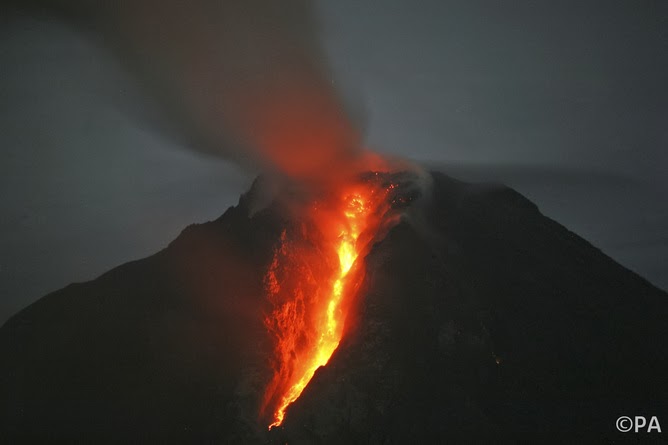
Thank goodness Mount Sinabung isn’t a supervolcano. Credit: Binsar Bakkara/AP
Devastating supervolcanoes can erupt simply due to changes that happen in their giant magma chambers as they slowly cool, according to a new study. This finding marks the first time researchers have been able to explain the mechanism behind the eruptions of the largest volcanoes on Earth.
Geologists have identified the roots of a number of ancient and possible future supervolcanoes across the globe. No supervolcano has yet exploded in human history, but the rock record demonstrates how devastating any eruption would be to today’s civilisation. Perhaps most famous is the Yellowstone supervolcano in Wyoming, which has erupted three times in the past two million years (the last eruption occurred 600,000 years ago).
These giant volcanic time bombs seem to explode once every few hundred thousand years, and when they do, they throw huge volumes of ash into the sky. At Yellowstone, the eruption that happened two million years ago ejected more than 2,000km3 of material – enough to cover Greater London in a mile-thick layer of ash.
It is estimated that a super-eruption like that would drive a global temperature drop of 10˚C for more than a decade. Such a dramatic change in global climate is difficult to comprehend. Aside from the instant local devastation, there would be global impacts such as crop failures, followed by large famines.
Despite their potential threat, comparable to a large asteroid impact, the mechanisms and origins of super-eruptions have remained obscure. Modestly sized volcanoes operate on different time-scales and magnitudes, and their eruptions appear to be triggered by pulses of molten rock (magma), which increase the pressure in the underground magma chambers that feed their vents.
Two papers recently published in the journal Nature Geoscience try to solve the mystery of how super volcanoes are formed and how they erupt.
Using experiments and computer modelling, scientists have discovered what drives a super-eruption. They find that, over time, the underground magma becomes increasingly more buoyant. Eventually, it becomes a bit like a beach ball held down beneath the waves—when it is released, it shoots into the air, forced up by the dense water around it.
In the first paper, a team led by Wim Malfait and Carmen Sanchez-Valle of ETH Zurich used a synchrotron (an accelerator that can generate intense X-rays) to measure the density, temperature, and pressure of molten rock held in conditions resembling those of a magma chamber several kilometres below the surface. This required them to mimic deep Earth conditions in the lab at the European Synchrotron Radiation Facility, holding samples at temperatures up to 1,700˚C and the pressure of 36,000 atmospheres.
To feed a supervolcano you need a huge magma chamber. The Zurich team’s results show that, as the magma chamber cools, it begins to solidify and crystals grow in it that are denser than the magma. As these fall to the base of the chamber, the remaining molten rock gets progressively less dense. If there is enough of it, their measurements indicate that the magma eventually becomes light enough that it can force its way through more than 10km of Earth’s overlying crust.
Co-author Carmen Sanchez-Valle, also at ETH Zurich, said: “Our research has shown that the pressure is actually large enough for the Earth’s crust to break. As it rises to the surface, the magma will expand violently, which is a well known origin of a volcanic explosion”.
The second paper by Luca Caricchi and colleagues at the University of Bristol, describes computer simulations of the same processes, finding that the buoyancy of melt in maturing magma chambers is also key to these huge events.
This contrasts with the way that more familiar smaller volcanoes erupt. There, blasts follow directly from rapid injections of magma, or from external events that release the pressure on it, such as earthquakes or even the melting of overlying glaciers, as seen in Iceland recently.
The results indicate that supervolcanoes just require a steady accumulation of molten rock that remains hot enough that it does not completely solidify—a massive eruption is then simply a matter of time. Thus, the eruption of massive supervolcanoes seems to be an inevitable part of their “life cycle”. Just as a sufficiently large star will necessarily generate a supernova, so a huge magma chamber should eventually become a massive eruption.
Note : This story is published courtesy of The Conversation (under Creative Commons-Attribution/No derivatives).
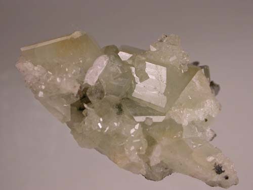
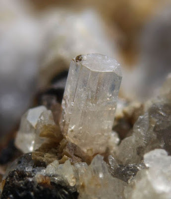
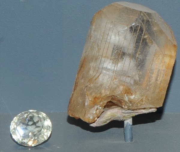
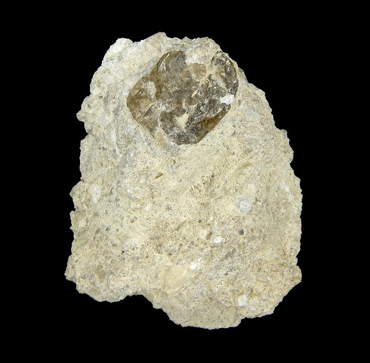
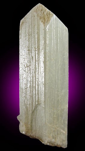
Chemical Formula: CaB2Si2O8 Locality: Danbury, Connecticut. Name Origin: Named after its location.
Danburite is a calcium boron silicate mineral with a chemical formula of CaB2Si2O8.
It has a Mohs hardness of 7 to 7.5 and a specific gravity of 3.0. The mineral has an orthorhombic crystal form. It is usually colourless, like quartz, but can also be either pale yellow or yellowish-brown. It typically occurs in contact metamorphic rocks.
The Dana classification of minerals categorizes danburite as a sorosilicate, while the Strunz classification scheme lists it as a tectosilicate; its structure can be interpreted as either.
Its crystal symmetry and form are similar to topaz; however, topaz is a calcium fluorine bearing nesosilicate. The clarity, resilience, and strong dispersion of danburite make it valuable as cut stones for jewelry.
It is named for Danbury, Connecticut, United States, where it was first discovered in 1839 by Charles Upham Shephard.
Physical Properties of Danburite
Cleavage: {001} Poor Color: Colorless, White, Gray, Brownish white, Straw yellow. Density: 2.97 – 3.02, Average = 2.99 Diaphaneity: Transparent to translucent Fracture: Sub Conchoidal – Fractures developed in brittle materials characterized by semi-curving surfaces. Hardness: 7 – Quartz Luminescence: Fluorescent and thermoluminescent (red), Short UV=violet blue, Long UV=blue to blue-green. Luster: Vitreous – Greasy Streak: white
The eruption plume from Grímsvön a few hours after the start of the eruption. Credit: Bergrún Arna Óladóttir
Bulging in land that occurs before a volcano erupts points to how much ash will be spewed into the sky, providing a useful early warning for aviation, geologists in Iceland said on Sunday.
The telltale came from data from Global Positioning System (GPS) sensors placed around the notorious Icelandic volcano Grimsvoetn, they said.
Just before Grimsvoetn blew its stack in May 2011, the ground around the volcano started to bulge.
In a brief but violent eruption, it disgorged a 20-kilometre-high (12-mile) plume of ash, equivalent to 0.27 square kilometres (0.06 cubic miles) of material.
By matching the ground deformation with the volume of the ash, the scientists got a snapshot of conditions that prevailed in the magma chamber below the volcano before the eruption.
The magma chamber is a vessel that progressively fills with injections of molten rock.
When the pressure becomes too great, the magma is expelled through cracks, forming ash as it cools in its passage through the air.
The timing of the eruption and the size of the ash plume depend on several factors within this chamber.
They include the volume of magma, the force at which it is expelled and the resilience of the rock walls of the chamber itself to the mounting pressure.
In the study published in Nature Geoscience, the team, led by Sigrun Hreinsdottir of the Nordic Volcanological Centre in Reykjavik said the magma chamber was about three kilometres (1.9 miles) beneath Grimsvoetn.
The signature from the groundswell points to a drop in pressure about 1.7 kms (1.06 miles) beneath the surface, about an hour before the eruption, as the magma headed upwards.
In volcanoes that are under close surveillance, the method could help warn of imminent eruptions and forecast the possible altitude of ash clouds, the authors said.
“If interpreted in near-real time, these observations could greatly improve forecasting of the onset and evolution of explosive eruptions and volcanic plume height,” they said.
Located at the heart of Iceland’s biggest glacier, Vatnajoekull, Grimsvoetn is Iceland’s most active volcano. Prior to 2011, it had erupted nine times between 1922 and 2004.
The 2011 eruption raised fears of a repeat of the air travel chaos caused by a blast the previous year at the nearby Eyjafjoell volcano, which led to the world’s biggest airspace shutdown since World War II, affecting more than 100,000 flights and eight million passengers.
Despite spewing out more ash in 24 hours than Eyjafjoell did in three weeks, Grimsvoetn caused far fewer disruptions.
The eruption swiftly ended, and the number of flights grounded counted in the hundreds.
The study appears in the journal Nature Geoscience.
An LMU team has, for the first time, created volcanic lightning in the lab and captured it on film. The new findings may permit rapid characterization of ash clouds released by volcanic eruptions and improve forecasting of their behavior.
When the Icelandic volcano Eyjafjallajökull erupted in April 2010, launching a towering column of ash into the skies, the cloud was observed to be laced with lightning flashes. LMU volcanologists led by Professor Donald Dingwell, Director of the Department of Earth and Environmental Sciences at LMU, have now generated such volcanic lightning in the laboratory, as they report in a recent issue of the journal Geology. “Our experiments demonstrate that there is a relationship between the concentration of fine particles in the ash plume and the number of flashes produced,” says departmental researcher Dr. Corrado Cimarelli.
Turbulence and particle charging
The volcanologists performed their experiments with natural ash obtained from several volcanoes, including Eyjafjallajökull. The ash was loaded into a shock tube and subjected to the kinds of pressures found in the magma chambers of active volcanos just prior to an eruption. Upon sudden decompression, the ash is expelled vertically in a turbulent plume made up of a mixture of gas and solid particles of ash. And indeed, the researchers observe lightning flashes, on the order of tens of centimeters in length, within the column, where collision and fragmentation of ash particles leads to the creation of charged surfaces. When oppositely charged surfaces interact, the electrical energy is dissipated as lightning.
The team recorded the dynamics of the process with the help of high-speed cameras which can capture motions that are imperceptible to the naked eye. In addition, they measured the distribution of electrically charge using two antennas. Videos of the experiments are available on the website maintained by the Department of Earth and Environmental Sciences.
The new study confirms that the incidence of lightning is related to the relative amount of very fine particles in the plume. The smaller the particles, the larger the number of flashes observed. “That in turn implies that observations of volcanic lightning could allow one to deduce the concentration and size distribution of the ash particles released during an eruption. And that information is crucial for efforts to predict how the particles will behave in the atmosphere, and how they might affect air traffic,” says Corrado Cimarelli. – Everyone remembers the disruption caused to transatlantic and European flight schedules by the clouds of ash released during the eruption of Eyjafjallajökull in April 2010.
The new findings also contribute to a better understanding of the mechanisms that underlie the self-charging of dust particles that are subjected to turbulence. They are thus relevant not only to other atmospheric phenomena, such as sandstorms, but also to industrial processes that involve interactions between mobile streams of particulate matter.
Note : The above story is based on materials provided by Ludwig Maximilian University of Munich
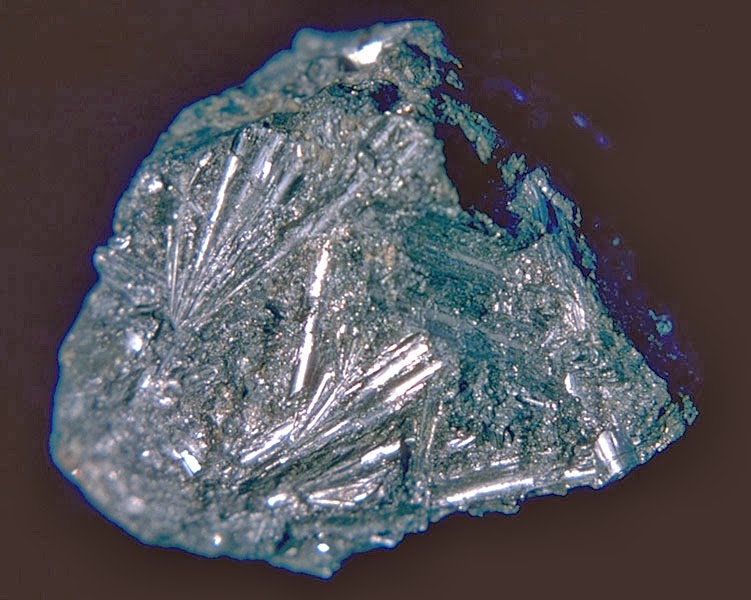
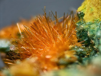
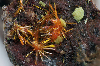
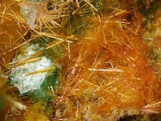
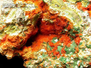
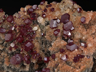
Locality: Trinacria Mine, Callipampa, Poopó Province, Oruro Department, Bolivia Dimensions: 2.9 cm x 2 cm x 1.2 cm “Courtesy of Rob Lavinsky, The Arkenstone, www.iRocks.com”
Chemical Formula: Pb3Sn4FeSb2S14 Locality: Poopo, in Oruro, Boliva. Name Origin: From the Greek, kylindros, “cylinder.”
Cylindrite is a sulfosalt mineral containing tin, lead, antimony and iron with formula: Pb3Sn4FeSb2S14. It forms triclinic pinacoidal crystals which often occur as tubes or cylinders which are in fact rolled sheets. It has a black to lead grey metallic colour with a Mohs hardness of 2 to 3 and a specific gravity of 5.4.
It was first discovered in the Santa Cruz mine, Oruro Department, Bolivia in 1893. The name arises from its curious cylindrical crystal which it forms almost uniquely among minerals.
Physical Properties of Cylindrite
Cleavage: None Color: Lead gray, Grayish black. Density: 5.4 – 5.42, Average = 5.41 Diaphaneity: Opaque Fracture: Malleable – Deforms rather than breaking apart with a hammer. Hardness: 2.5 – Finger Nail Luster: Metallic Streak: black
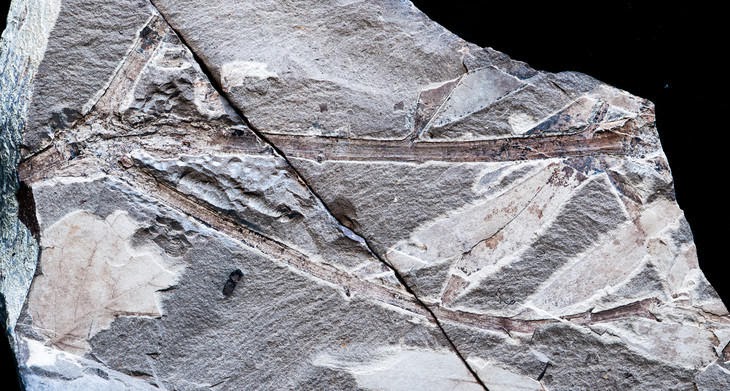
Fossil of leafy Agathis tree branch. (Credit: Peter Wilf/Penn State)
Today in Australia they call it Kauri, in Asia they call it Dammar, and in South America it does not exist at all unless planted there. But 52 million years ago the giant coniferous evergreen tree known to botanists as Agathis thrived in the Patagonian region of Argentina, according to an international team of paleobotanists, who have found numerous fossilized remains there.
“These spectacular fossils reveal that Agathis is old and had a huge range that no one knew about — from Australia to South America across Antarctica,” said Peter Wilf, professor of geoscience, Penn State.
Agathis trees currently grow thousands of miles from Argentina, ranging from Sumatra to New Zealand. They often prefer mountain rainforests, where it is wet and warm all year round. They can grow as tall as 200 feet, but are usually between 130 and 150 feet at maturity. Economically, they are prized and heavily cut for their soft, workable wood. In the past, the Agathis resin, known as manila copal, was exploited for linoleum and varnishes, but synthetics replaced most of that use.
The researchers report in the current issue of American Journal of Botany that “Agathis was a dominant, keystone element of the Patagonian Eocene floras, alongside numerous other plant taxa that still associate with it in Australasia and Southeast Asia.”
“There is a fossil record of Agathis in Australia and New Zealand, where it still lives,” said Wilf. “However, Agathis fossils have never been found anywhere else until now, and they have never been as complete as these.”
Wilf and his colleagues work at two sites in Patagonia, Argentina: Laguna del Hunco that dates to the early Eocene at about 52.2 million years ago, and Río Pichileufú dating to about 47.7 million years ago.
“These sites were discovered in the 1920s and 1930s, but the remoteness of the locations and the hardness of the rock are why they hadn’t been investigated in detail before we started in 1999,” said Wilf. “Now, with modern amenities — satellite phones for example — and especially the presence of our partner institution, the Egidio Feruglio Museum, in the same region as the dig sites, recovering these fossils becomes much easier.”
Agathis grew in Patagonia when South America was part of the remainder of the southern supercontinent of Gondwana, composed of South America, Antarctica and Australia. Much earlier, India, Madagascar, New Zealand and Africa separated and moved north, but around the time of these fossils, South America was just beginning to part from Antarctica, which was not ice covered at the time.
“Agathis probably existed in all three areas, Australia, Antarctica and South America, at that time,” said Wilf. “Climate change in Antarctica — the cold and ice — killed them there, and a change to seasonal dryness in southern South America put an end to them in Patagonia.”
Subsequently, the trees, which are wind dispersed, moved away from the cooling south, and some left northward-moving Australia for southeast Asia, where they thrive except for human interference, but they no longer grow in cold, often dry, Patagonia.
Wilf ‘s team recovered not only leaves, but also numerous branches, pollen cones, seed cones and even a winged seed still attached to the cone. The various species of Agathis are usually identified by their pollen cones, so this is the first time that a fossil Agathis could be directly compared to trees growing today.
“We also went to Borneo and studied the most similar living relative of the fossil Agathis, a threatened species there,” said Wilf. “We collected DNA samples to better understand the fossil-modern relationship.”
According to the researchers, the Argentinian fossil Agathis clearly belongs to the same natural group as those living today up to almost 10,000 miles away in the tropical West Pacific.
“Agathis is a very dramatic example of survival via huge range shifts, from the far south to the tropics, in response to climate change and land movement over millions of years,” said Wilf. “It is not clear that Agathis can adapt to the severely more rapid human-induced pressures it is experiencing now from deforestation, selective logging and climate change.”
Also working on this research are Ignacio H. Escapa and Rubén Cúneo, Consejo Nacional de Investigaciones Científicas y Técnicas and Museo Paleontológico Egidio Feruglio, Chubut, Argentina; Robert M. Kooyman, National Herbarium of New South Wales, Sydney; Kirk R. Johnson, Smithsonian Institution; and Ari Iglesias, Consejo Nacional de Investigaciones Científicas y Técnicas and División Palontología, Universidad Nacional del Comahue, Río Negro, Argentina.
The National Science Foundation, the David and Lucile Packard Foundation, National Geographic Society,University of Pennsylvania Research Foundation and the Andrew W. Mellon Foundation supported this work.
Note : The above story is based on materials provided by Penn State.
This artist’s concept depicts Kepler-69c, a super-Earth-size planet in the habitable zone of a star like our sun, located about 2,700 light-years from Earth in the constellation Cygnus. (Credit: NASA Ames/JPL-Caltech)
Massive terrestrial planets, called “super-Earths,” are known to be common in our galaxy, the Milky Way. Now a Northwestern University astrophysicist and a University of Chicago geophysicist report the odds of these planets having an Earth-like climate are much greater than previously thought.
Nicolas B. Cowan and Dorian Abbot’s new model challenges the conventional wisdom which says super-Earths actually would be very unlike Earth — each would be a waterworld, with its surface completely covered in water. They conclude that most tectonically active super-Earths — regardless of mass — store most of their water in the mantle and will have both oceans and exposed continents, enabling a stable climate such as Earth’s.
Cowan is a postdoctoral fellow at Northwestern’s Center for Interdisciplinary Exploration and Research in Astrophysics (CIERA), and Abbot is an assistant professor in geophysical sciences at UChicago.
“Are the surfaces of super-Earths totally dry or covered in water?” Cowan said. “We tackled this question by applying known geophysics to astronomy.
“Super-Earths are expected to have deep oceans that will overflow their basins and inundate the entire surface, but we show this logic to be flawed,” he said. “Terrestrial planets have significant amounts of water in their interior. Super-Earths are likely to have shallow oceans to go along with their shallow ocean basins.”
In their model, Cowan and Abbot treated the intriguing exoplanets like Earth, which has quite a bit of water in its mantle, the rocky part that makes up most of the volume and mass of the planet. The rock of the mantle contains tiny amounts of water, which quickly adds up because the mantle is so large. And a deep water cycle moves water between oceans and the mantle. (An exoplanet, or extrasolar planet, is a planet outside our solar system.)
Cowan presented the findings at a press conference, “Windows on Other Worlds,” held Jan. 7 at the 223rd meeting of the American Astronomical Society (AAS) annual meeting in Washington, D.C.
He also will discuss the research at a scientific session to be held from 2 to 3:30 p.m. EST Wednesday, Jan. 8, at the AAS meeting (Potomac Ballroom D, Gaylord National Resort and Convention Center). The study will be published Jan. 20 in the Astrophysical Journal.
Water is constantly traded back and forth between the ocean and the rocky mantle because of plate tectonics, Cowan and Abbot said. The division of water between ocean and mantle is controlled by seafloor pressure, which is proportional to gravity.
Accounting for the effects of seafloor pressure and high gravity are two novel factors in their model. As the size of the super-Earths increase, gravity and seafloor pressure also go up.
“We can put 80 times more water on a super-Earth and still have its surface look like Earth,” Cowan said. “These massive planets have enormous seafloor pressure, and this force pushes water into the mantle.”
It doesn’t take that much water to tip a planet into being a waterworld. “If Earth was 1 percent water by mass, we’d all drown, regardless of the deep water cycle,” Cowan said. “The surface would be covered in water. Whether or not you have a deep water cycle really matters for planets that are one one-thousandth or one ten-thousandth water.”
The ability of super-Earths to maintain exposed continents is important for planetary climate. On planets with exposed continents, like Earth, the deep carbon cycle is mediated by surface temperatures, which produces a stabilizing feedback (a thermostat on geological timescales).
“Such a feedback probably can’t exist in a waterworld, which means they should have a much smaller habitable zone,” Abbot said. “By making super-Earths 80 times more likely to have exposed continents, we’ve dramatically improved their odds of having an Earth-like climate.”
Cowan and Abbot accede that there are two major uncertainties in their model: that super-Earths have plate tectonics and the amount of water Earth stores in its mantle.
“These are the two things we would like to know better to improve our model,” Cowan said. “Our model is a shot from the hip, but it’s an important step in advancing how we think about super-Earths.”
Note : The above story is based on materials provided by Northwestern University. The original article was written by Megan Fellman.
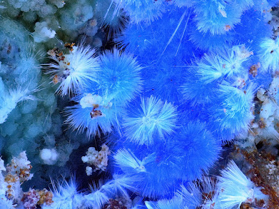
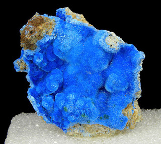
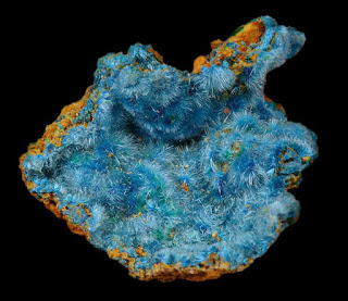
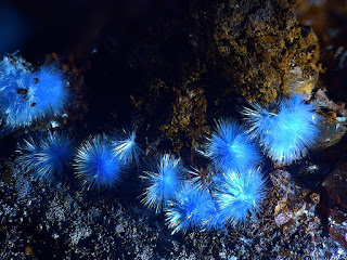
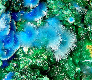
Chemical Formula: Cu4Al2(SO4)(OH)12 · 2H2O Locality: Moldava Noua (Moldawa, Új Moldova), Banat, Romania. Name Origin: From the Greek, kyaneos, “blue” and triches, “hair,” hence, blue hair.
Cyanotrichite is a hydrous copper aluminium sulfate mineral with formula Cu4Al2(SO4)(OH)12 · 2H2O, also known as lettsomite. Cyanotrichite forms velvety radial acicular crystal aggregates of extremely fine fibers. It crystallizes in the orthorhombic system and forms translucent bright blue acicular crystal clusters or drusey coatings. The Mohs hardness is 2 and the specific gravity ranges from 2.74 to 2.95. Refractive indices are nα=1.588 nβ=1.617 nγ=1.655.
Occurrence and discovery
It is an oxidation product of primary copper mineralization in a weathering environment with abundant aluminium and sulfate. Associated minerals include brochantite, spangolite, chalcophyllite, olivenite, tyrolite, parnauite, azurite and malachite.
The main deposits are Cap la Garrone in the Var (France), Romania and Arizona (USA).
It was first described in 1839 from Moldova Nouă, Banat, Romania. The name is from Greek kyaneos for “blue” and triches for “hair” referring to the typical color and habit. Its earlier name, Lettsomite, is taken from the name of William Garrow Lettsom (1804–1887), co-author of the 1858 Manual of the Mineralogy of Great Britain and Ireland.
Physical Properties of Cyanotrichite
Cleavage: {???} Good Color: Sky blue, Light blue, Dark blue. Density: 2.74 – 2.95, Average = 2.84 Fracture: Uneven – Flat surfaces (not cleavage) fractured in an uneven pattern. Hardness: 2 – Gypsum Luminescence: Non-fluorescent. Luster: Silky Streak: pale blue
This is the Hasan Dagi volcano. Credit: Janet C. Harvey
Volcanic rock dating suggests the painting of a Çatalhöyük mural may have overlapped with an eruption in Turkey according to results published January 8, 2014, in the open access journal PLOS ONE by Axel Schmitt from the University of California Los Angeles and colleagues from other institutions.
Scientists analyzed rocks from the nearby Hasan Dagi volcano in order to determine whether it was the volcano depicted in the mural from ~6600 BC in the Catalhöyük Neolithic site in central Turkey. To determine if Hasan Dagi was active during that time, scientists collected and analyzed volcanic rock samples from the summit and flanks of the Hasan Dagi volcano using (U-Th)/He zircon geochronology. These ages were then compared to the archeological date of the mural.
Volcanic rock textures and ages support the interpretation that residents of Çatalhöyük may have recorded an explosive eruption of Hasan Dagi volcano. The dating of the volcanic rock indicated an eruption around 6900 BC, which closely overlaps with the time the mural was estimated to have been painted in Çatalhöyük. The overlapping timeframes indicate humans in the region may have witnessed this eruption.
Alternative interpretations of the mural include the depiction of a leopard skin, consistent with other art at the Çatalhöyük site.
Schmitt adds, “We tested the hypothesis that the Çatalhöyük mural depicts a volcanic eruption and discovered a geological record consistent with this hypothesis. Our work also demonstrates that Hasan Dagi volcano has potential for future eruptions.”
Note : The above story is based on materials provided by Public Library of Science
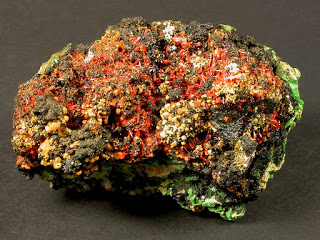
Chemical Formula: Pb3(UO2)8O8(OH)6 · 3H2O Locality: Shinkolobwe Mine (Kasolo Mine), Shinkolobwe, Katanga Copper Crescent, Katanga (Shaba), Democratic Republic of Congo (Zaïre) Name Origin: Named for Pierre Curie (1859-1906) and Marie Curie-Sklodowska (1867 – 1934), French research team of radioactive minerals. Discoverd the element radium.
Curite is a lead uranium oxide mineral with formula: Pb3(UO2)8O8(OH)6 · 3H2O. It is named after the physicists Marie and Pierre Curie, who are both known for their work on radioactivity. The type locality is the Shinkolobwe Mine.
Physical Properties of Curite
Cleavage: {100} Good, {110} Good Color: Yellow, Reddish orange, Brownish yellow. Density: 7.19 Diaphaneity: Transparent to Translucent Fracture: Brittle – Generally displayed by glasses and most non-metallic minerals. Hardness: 4-5 – Fluorite-Apatite Luster: Adamantine Streak: orange
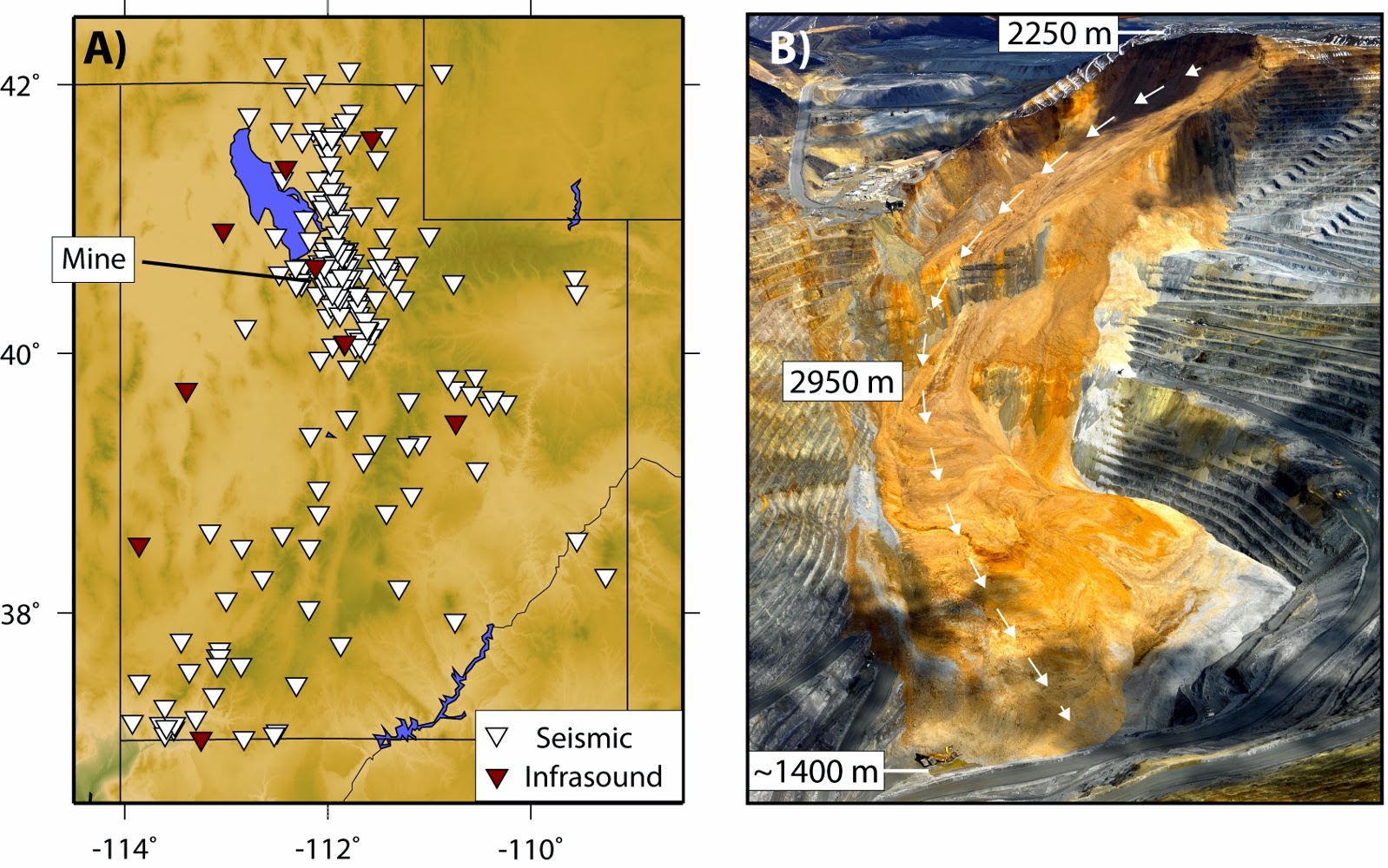
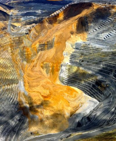
This is Figure 1 from K.L. Pankow et al. of megalandslide at the Bingham Canyon Mine, Utah. Landslide image copyright Kennecott Utah Copper. Credit: Seismic/Infrasound image by K.L. Pankow et al. Landslide image copyright Kennecott Utah Copper.
Landslides are one of the most hazardous aspects of our planet, causing billions of dollars in damage and thousands of deaths each year. Most large landslides strike with little warning—and thus geologists do not often have the ability to collect important data that can be used to better understand the behavior of these dangerous events. The 10 April 2013 collapse at Kennecott’s Bingham Canyon open-pit copper mine in Utah is an important exception.
Careful and constant monitoring of the conditions of the Bingham Canyon mine identified slow ground displacement prior to the landslide. This allowed the successful evacuation of the mine area prior to the landslide and also alerted geologists at the University of Utah to enable them to successfully monitor and study this unique event.
The landslide—the largest non-volcanic landslide in the recorded history of North America—took place during two episodes of collapse, each lasting less than two minutes. During these events about 65 million cubic meters of rock—with a total mass of 165 million tons—collapsed and slid nearly 3 km (1.8 miles) into the open pit floor.
In the January 2014 issue of GSA Today, University of Utah geologists, led by Dr. Kristine Pankow, report the initial findings of their study of the seismic and sound-waves generated by this massive mega-landslide. Pankow and her colleagues found that the landslide generated seismic waves that were recorded by both nearby seismic instruments, but also instruments located over 400 km from the mine. Examining the details of these seismic signals, they found that each of the two landslide events produced seismic waves equivalent to a magnitude 2 to 3 earthquake.
Interestingly, while there were no measurable seismic events prior to the start of the landslide, the team did measure up to 16 different seismic events with characteristics very much like normal “tectonic” earthquakes beneath the mine. These small (magnitude less than 2) earthquakes happened over a span of 10 days following the massive landslide and appear to be a rare case of seismic activity triggered by a landslide, rather than the more common case where an earthquake serves as the trigger to the landslide.
Later studies of both the seismic and sound waves produced by this landslide will allow Pankow and her team to characterize the failure and displacement of the landslide material in much more detail.
Note : The above story is based on materials provided by Geological Society of America
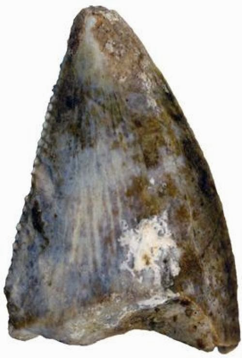
Adaffa Theropod Tooth: This isolated tooth evidences the first identifiable carnivorous theropod dinosaur from the Arabian Peninsula. Abelisaurids like this specimen have been found in the ancient Gondwanan landmasses of North Africa, Madagascar and South America. (Credit: Photo by Maxim Leonov (Palaeontological Institute, Moscow) / Creative Commons Attribution, No Derivatives)
Dinosaur fossils are exceptionally rare in the Arabian Peninsula. An international team of scientists from Uppsala University, Museum Victoria, Monash University, and the Saudi Geological Survey have now uncovered the first record of dinosaurs from Saudi Arabia.What is now dry desert was once a beach littered with the bones and teeth of ancient marine reptiles and dinosaurs.
A string of vertebrae from the tail of a huge “Brontosaurus-like” sauropod, together with some shed teeth from a carnivorous theropod represent the first formally identified dinosaur fossils from Saudi Arabia, and were found in the north-western part of the Kingdom along the coast of the Red Sea.
The remains were discovered during excavations conducted by a team of scientists working under the auspices of the Saudi Geological Survey, Jeddah.
The dinosaur finds were recently published in the scientific journal PLOS ONE and jointly authored by participating researchers from Sweden, Australia and Saudi Arabia.
“Dinosaur fossils are exceptionally rare in the Arabian Peninsula, with only a handful of highly fragmented bones documented this far” says Dr Benjamin Kear, based at Uppsala University in Sweden and lead author of the study.
“This discovery is important not only because of where the remains were found, but also because of the fact that we can actually identify them. Indeed, these are the first taxonomically recognizable dinosaurs reported from the Arabian Peninsula” Dr Kear continues.
“Dinosaur remains from the Arabian Peninsula and the area east of the Mediterranean Sea are exceedingly rare because sedimentary rocks deposited in streams and rivers during the Age of Dinosaurs are rare, particularly in Saudi Arabia itself” says Dr Tom Rich from Museum Victoria in Australia.
When these dinosaurs were alive, the Arabian landmass was largely underwater and formed the north-western coastal margin of the African continent.
“The hardest fossil to find is the first one. Knowing that they occur in a particular area and the circumstances under which they do, makes finding more fossils significantly less difficult” says Dr Rich.
The teeth and bones are approximately 72 million years old.
Two types of dinosaur were described from the assemblage, a bipedal meat-eating abelisaurid distantly related to Tyrannosaurus but only about six metres long, and a plant-eating titanosaur perhaps up to 20 metres in length.
Similar dinosaurs have been found in North Africa, Madagascar and as far away as South America.
Note : The above story is based on materials provided by Uppsala Universitet.
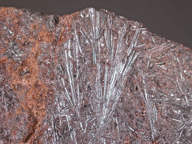
Chemical Formula: Cu2O Locality: Commonly in the copper deposits of SW USA and in Chile. Name Origin: From the Latin, cuprum, meaning copper. Chalcotrichite from the Greek, meaning “hairy copper.”
Cuprite is an oxide mineral composed of copper(I) oxide Cu2O, and is a minor ore of copper.
Its dark crystals with red internal reflections are in the isometric system hexoctahedral class, appearing as cubic, octahedral, or dodecahedral forms, or in combinations. Penetration twins frequently occur. In spite of its nice color it is rarely used for jewelry because of its low Mohs hardness of 3.5 to 4. It has a relatively high specific gravity of 6.1, imperfect cleavage and a brittle to conchoidal fracture. The luster is sub-metallic to brilliant adamantine. The “chalcotrichite” variety typically shows greatly elongated (parallel to [001]) capillary or needle like crystals forms.
It is a secondary mineral which forms in the oxidized zone of copper sulfide deposits. It frequently occurs in association with native copper, azurite, chrysocolla, malachite, tenorite and a variety of iron oxide minerals. It is known as ruby copper due to its distinctive red color.
Cuprite was first described in 1845 and the name derives from the Latin cuprum for its copper content.
Cuprite is found in the Ural Mountains, Altai Mountains, and Sardinia, and in more isolated locations in Cornwall, France, Arizona, Chile, Bolivia, and Namibia.
This artist’s impression depicts the magma chamber of a supervolcano with partially molten magma at the top. The pressure from the buoyancy is sufficient to initiate cracks in the Earth’s crust in which the magma can penetrate. (Credit: ESRF/Nigel Hawtin)
Scientists have reproduced the conditions inside the magma chamber of a supervolcano to understand what it takes to trigger its explosion. These rare events represent the biggest natural catastrophes on Earth except for the impact of giant meteorites. Using synchrotron X-rays, the scientists established that supervolcano eruptions may occur spontaneously, driven only by magma pressure without the need for an external trigger. The results are published in Nature Geosciences.
The team was led by Wim Malfait and Carmen Sanchez-Valle of ETH Zurich (Switzerland) and comprised scientists from the Paul Scherrer Institute in Villigen (Switzerland), Okayama University (Japan), the Laboratory of Geology of CNRS, Université Lyon 1 and ENS Lyon (France) and the European Synchrotron (ESRF) in Grenoble (France).
A well-known supervolcano eruption occurred 600,000 years ago in Wyoming in the United States, creating a huge crater called a caldera, in the centre of what today is Yellowstone National Park. When the volcano exploded, it ejected more than 1000 km3 of ash and lava into the atmosphere, 100 times more than Mt Pinatubo in the Philippines did in 1992. Big volcanic eruptions have a major impact on the global climate. The Mt Pinatubo eruption decreased the global temperature by 0.4 degrees Celsius for a few months. The predictions for a super volcano are a fall in temperatures by 10 degrees Celsius for 10 years.
According to a 2005 report by the Geological Society of London, “Even science fiction cannot produce a credible mechanism for averting a super-eruption. We can, however, work to better understand the mechanisms involved in super-eruptions, with the goal of being able to predict them ahead of time and provide a warning for society. Preparedness is the key to mitigation of the disastrous effects of a super-eruption.”
The mechanisms that trigger supervolcano eruptions have remained elusive to date. The main reason is that the processes inside a supervolcano are different from those in conventional volcanoes like Mt. Pinatubo which are better understood. A supervolcano possesses a much larger magma chamber and it is always located in an area where the heat flow from the interior of Earth to the surface is very high. As a consequence, the magma chamber is very large and hot but also plastic: its shape changes as a function of the pressure when it gradually fills with hot magma. This plasticity allows the pressure to dissipate more efficiently than in a normal volcano whose magma chamber is more rigid. Supervolcanoes therefore do not erupt very often.
So what changes in the lead up to an eruption? Wim Malfait explains: “The driving force is an additional pressure which is caused by the different densities of solid rock and liquid magma. It is comparable to a football filled with air under water, which is forced upwards by the denser water around it.” Whether this additional pressure alone could eventually become sufficiently high to crack Earth’s crust, leading to a violent eruption, or whether an external energy source like an Earthquake is required has only now been answered.
Whilst it is virtually impossible to drill a hole into the magma chamber of a supervolcano given the depth at which these chambers are buried, one can simulate these extreme conditions in the laboratory. “The synchrotron X-rays at the ESRF can then be used to probe the state — liquid or solid — and the change in density when magma crystallises into rock” says Mohamed Mezouar, scientist at the ESRF and member of the team. Jean-Philippe Perrillat from the Laboratory of Geology of CNRS, Université Lyon 1 and ENS Lyon adds: “Temperatures of up to 1700 degrees and pressures of up to 36,000 atmospheres can be reached inside the so-called Paris-Edinburgh press, where speck-sized rock samples are placed between the tips of two tungsten carbide anvils and then heated with a resistive furnace. This special set-up was used to accurately determine the density of the liquid magma over a wide range of pressures and temperatures.”
Magma often includes water, which as vapour adds additional pressure. The scientists also determined magma densities as a function of water content.
The results of their measurements showed that the pressure resulting from the differences in density between solid and liquid magma rock is sufficient in itself to crack more than ten kilometres of Earth’s crust above the magma chamber. Carmen Sanchez-Valle concludes: “Our research has shown that the pressure is actually large enough for Earth’s crust to break. The magma penetrating into the cracks will eventually reach Earth’s surface, even in the absence of water or carbon dioxide bubbles in the magma. As it rises to the surface, the magma will expand violently, which is the well known origin of a volcanic explosion.”
Note : The above story is based on materials provided by CNRS.
The April 10, 2013, landslide at Rio Tinto-Kennecott Utah Copper’s Bingham Canyon mine contains enough debris to bury New York City’s Central Park 66 feet deep, according to a new University of Utah study. The slide happened in the form of two rock avalanches 95 minutes apart. The first rock avalanche included grayer bedrock material seen around the margins of the lower half of the slide. The second rock avalanche is orange in color, both from bedrock and from waste rock from mining. The new study found the landslide triggered 16 small quakes. Such triggering has not been noted previously. The slide likely was the largest nonvolcanic landslide in North America’s modern history. Credit: Kennecott Utah Copper.
Last year’s gigantic landslide at a Utah copper mine probably was the biggest nonvolcanic slide in North America’s modern history, and included two rock avalanches that happened 90 minutes apart and surprisingly triggered 16 small earthquakes, University of Utah scientists discovered.
The landslide – which moved at an average of almost 70 mph and reached estimated speeds of at least 100 mph – left a deposit so large it “would cover New York’s Central Park with about 20 meters (66 feet) of debris,” the researchers report in the January 2014 cover study in the Geological Society of America magazine GSA Today.
While earthquakes regularly trigger landslides, the gigantic landslide the night of April 10, 2013, is the first known to have triggered quakes. The slide occurred in the form of two huge rock avalanches at 9:30 p.m. and 11:05 p.m. MDT at Rio Tinto-Kennecott Utah Copper’s open-pit Bingham Canyon Mine, 20 miles southwest of downtown Salt Lake City. Each rock avalanche lasted about 90 seconds.
While the slides were not quakes, they were measured by seismic scales as having magnitudes up to 5.1 and 4.9, respectively. The subsequent real quakes were smaller.
Kennecott officials closely monitor movements in the 107-year-old mine – which produces 25 percent of the copper used in the United States – and they recognized signs of increasing instability in the months before the slide, closing and removing a visitor center on the south edge of the 2.8-mile-wide, 3,182-foot-deep open pit, which the company claims is the world’s largest manmade excavation.
Landslides – including those at open-pit mines but excluding quake-triggered slides – killed more than 32,000 people during 2004-2011, the researchers say. But no one was hurt or died in the Bingham Canyon slide. The slide damaged or destroyed 14 haul trucks and three shovels and closed the mine’s main access ramp until November.
“This is really a geotechnical monitoring success story,” says the new study’s first author, Kris Pankow, associate director of the University of Utah Seismograph Stations and a research associate professor of geology and geophysics. “No one was killed, and yet now we have this rich dataset to learn more about landslides.”
There have been much bigger human-caused landslides on other continents, and much bigger prehistoric slides in North America, including one about five times larger than Bingham Canyon some 8,000 years ago at the mouth of Utah’s Zion Canyon.
But the Bingham Canyon Mine slide “is probably the largest nonvolcanic landslide in modern North American history,” said study co-author Jeff Moore, an assistant professor of geology and geophysics at the University of Utah.
There have been numerous larger, mostly prehistoric slides – some hundreds of times larger. Even the landslide portion of the 1980 Mount St. Helens eruption was 57 times larger than the Bingham Canyon slide.
News reports initially put the landslide cost at close to $1 billion, but that may end up lower because Kennecott has gotten the mine back in operation faster than expected.
Until now, the most expensive U.S. landslide was the 1983 Thistle slide in Utah, which cost an estimated $460 million to $940 million because the town of Thistle was abandoned, train tracks and highways were relocated and a drainage tunnel built.
Pankow and Moore conducted the study with several colleagues from the university’s College of Mines and Earth Sciences: J. Mark Hale, an information specialist at the Seismograph Stations; Keith Koper, director of the Seismograph Stations; Tex Kubacki, a graduate student in mining engineering; Katherine Whidden, a research seismologist; and Michael K. McCarter, professor of mining engineering.
The study was funded by state of Utah support of the University of Utah Seismograph Stations and by the U.S. Geological Survey.
The University of Utah researchers say the Bingham Canyon slide was among the best-recorded in history, making it a treasure trove of data for studying slides.
Kennecott has estimated the landslide weighed 165 million tons. The new study estimated the slide came from a volume of rock roughly 55 million cubic meters (1.9 billion cubic feet). Rock in a landslide breaks up and expands, so Moore estimated the landslide deposit had a volume of 65 million cubic meters (2.3 billion cubic feet).
Moore calculated that not only would bury Central Park 66 feet deep, but also is equivalent to the amount of material in 21 of Egypt’s great pyramids of Giza.
The landslide’s two rock avalanches were not earthquakes but, like mine collapses and nuclear explosions, they were recorded on seismographs and had magnitudes that were calculated on three different scales:
The first slide at 9:30 p.m. MDT measured 5.1 in surface-wave magnitude, 2.5 in local or Richter magnitude, and 4.2 in duration or “coda” magnitude.
The second slide at 11:05 p.m. MDT measured 4.9 in surface-wave magnitude, 2.4 in Richter magnitude and 3.5 in coda magnitude.
Pankow says the larger magnitudes more accurately reflect the energy released by the rock avalanches, but the smaller Richter magnitudes better reflect what people felt – or didn’t feel, since the Seismograph Stations didn’t receive any such reports. That’s because the larger surface-wave magnitudes record low-frequency energy, while Richter and coda magnitudes are based on high-frequency seismic waves that people usually feel during real quakes.
So in terms of ground movements people might feel, the rock avalanches “felt like 2.5,” Pankow says. “If this was a normal tectonic earthquake of magnitude 5, all three magnitude scales would give us similar answers.”
The slides were detected throughout the Utah seismic network, including its most distant station some 250 miles south on the Utah-Arizona border, Pankow says.
The Landslide Triggered 16 Tremors
The second rock avalanche was followed immediately by a real earthquake measuring 2.5 in Richter magnitude and 3.0 in coda magnitude, then three smaller quakes – all less than one-half mile below the bottom of the mine pit.
The Utah researchers sped up recorded seismic data by 30 times to create an audio file in which the second part of the slide is heard as a deep rumbling, followed by sharp gunshot-like bangs from three of the subsequent quakes.
Later analysis revealed another 12 tiny quakes – measuring from 0.5 to minus 0.8 Richter magnitude. (A minus 1 magnitude has one-tenth the power of a hand grenade.) Six of these tiny tremors occurred between the two parts of the landslide, five happened during the two days after the slide, and one was detected 10 days later, on April 20. No quakes were detected during the 10 days before the double landslide.
“We don’t know of any case until now where landslides have been shown to trigger earthquakes,” Moore says. “It’s quite commonly the reverse.”
A Long, Fast Landslide Runout
The landslide, from top to bottom, fell 2,790 vertical feet, but its runout – the distance the slide traveled – was almost 10,072 feet, or just less than two miles.
“It was a bedrock landslide that had a characteristically fast and long runout – much longer than we would see for smaller rockfalls and rockslides,” Moore says.
While no one was present to measure the speed, rock avalanches typically move about 70 mph to 110 mph, while the fastest moved a quickly as 220 mph.
So at Bingham Canyon, “we can safely say the material was probably traveling at least 100 mph as it fell down the steepest part of the slope,” Moore says.
The researchers don’t know why the slide happened as two rock avalanches instead of one, but Moore says, “A huge volume like this can fail in one episode or in 10 episodes over hours.”
The Seismograph Stations also recorded infrasound waves from the landslide, which Pankow says are “sound waves traveling through the atmosphere that we don’t hear” because their frequencies are so low.
Both seismic and infrasound recordings detected differences between the landslide’s two rock avalanches. For example, the first avalanche had stronger peak energy at the end that was lacking in the second slide, Pankow says.
“We’d like to be able to use data like this to understand the physics of these large landslides,” Moore says.
The seismic and infrasound recordings suggest the two rock avalanches were similar in volume, but photos indicate the first slide contained more bedrock, while the second slide contained a higher proportion of mined waste rock – although both avalanches were predominantly bedrock.
Note : The above story is based on materials provided by University of Utah
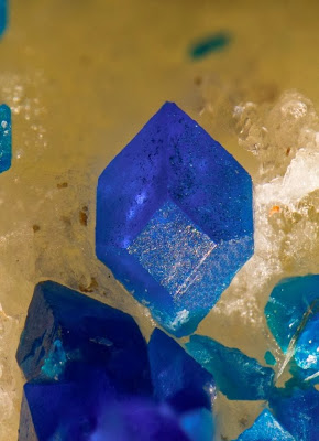
Chemical Formula: Pb21Cu20Cl42(OH)40 · 6H2O Locality: Boleo, near Santa Rosalia, Baja California Sur. Name Origin: Named for Edouard Cumenge (1828-1902), French mining engineer for the Boleo mines.
Cumengite is a rare mineral It shares a close relationship with another rare halide, boleite. Boleite and cumengite both come from the same type locality at Boleo, Baja California, Mexico; both resulted from the oxidation of igneous copper ore bodies; both have similar chemistries, although cumengite lacks silver; both have an attractive indigo blue color and both have interesting crystal forms. But all that is not the reason for the close relationship. Cumengite and boleite have about as close a relationship as two minerals can have since cumengite actually grows on the cube faces of boleite crystals.
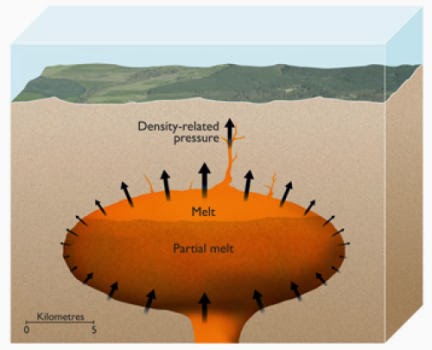
The 20-km diameter Laguna del Maule caldera in the Chilean Andes was created by at least three very large eruptions that occurred 1.5, 0.95 and 0.34 million years ago. In contrast, over the last 25,000 years the volcano has erupted 36 small lava domes, like the one in the right foreground, the most recent of which formed 2,000 years ago. Understanding why volcanoes such as Laguna del Maule alternate between infrequent very large (or “super”) eruptions and frequent small eruptions is the subject of a recent paper in Nature Geoscience by Jon Blundy and Catherine Annen from the School of Earth Sciences and colleagues in Switzerland and France. Credit: University of Bristol
Factors determining the frequency and magnitude of volcanic phenomena have been uncovered by an international team of researchers.
Experts from the Universities of Geneva, Bristol and Savoie carried out over 1.2 million simulations to establish the conditions in which volcanic eruptions of different sizes occur.
The team used numerical modelling and statistical techniques to identify the circumstances that control the frequency of volcanic activity and the amount of magma that will be released.
The researchers, including Professor Jon Blundy and Dr Catherine Annen from Bristol University’s School of Earth Sciences, showed how different size eruptions have different causes. Small, frequent eruptions are known to be triggered by a process called magma replenishment, which stresses the walls around a magma chamber to breaking point. However, the new research shows that larger, less frequent eruptions are caused by a different phenomenon known as magma buoyancy, driven by slow accumulation of low-density magma beneath a volcano.
Predictions of the scale of the largest possible volcanic eruption on earth have been made using this new insight. This is the first time scientists have been able to establish a physical link between the frequency and magnitude of volcanic eruptions and their findings will be published today in the journal Nature Geoscience.
“We estimate that a magma chamber can contain a maximum of 35,000 km3 of eruptible magma. Of this, around 10 per cent is released during a super-eruption, which means that the largest eruption could release approximately 3,500 km3 of magma”, explained lead researcher Luca Caricchi, assistant professor at the Section of Earth and Environmental Sciences at the University of Geneva and ex-research fellow at the University of Bristol.
Volcanic eruptions may be frequent yet their size is notoriously hard to predict. For example, the Stromboli volcano in Italy ejects magma every ten minutes and would take two days to fill an Olympic swimming pool. However, the last super-eruption of a volcano, which occurred over 70,000 years ago, spewed out enough magma to fill a billion swimming pools.
This new research identifies the main physical factors involved in determining the frequency and size of eruptions and is essential to understanding phenomena that effect human life, such as the 2010 ash cloud caused by the eruption of Eyjafallajökull in Iceland.
Professor Jon Blundy said: “Some volcanoes ooze modest quantities of magma at regular intervals, whereas others blow their tops in infrequent super-eruptions. Understanding what controls these different types of behaviour is a fundamental geological question.
“Our work shows that this behaviour results from interplay between the rate at which magma is supplied to the shallow crust underneath a volcano and the strength of the crust itself. Very large eruptions require just the right (or wrong!) combination of magma supply and crustal strength.”
The above story is based on materials provided by University of Bristol
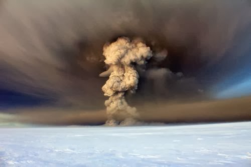
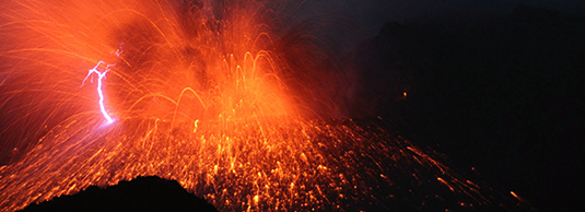
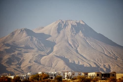
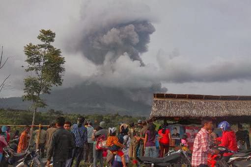
Indonesians look at the volcanic ash spewing up into the air from Mount Sinabung as it erupts in Karo, North Sumatra, on January 1, 2014
An Indonesian volcano that has erupted relentlessly for months shot volcanic ash into the air 30 times on Saturday, forcing further evacuations with more than 20,000 people now displaced, an official said.
Mount Sinabung on the western island of Sumatra sent rivers of lava flowing through an evacuation zone and columns of volcanic cloud up as high as 4,000 metres (13,000 feet), National Disaster Mitigation Agency spokesman Sutopo Purwo Nugroho said.
“Hot lava spewed from the volcano some 60 times, reaching up to five kilometres (three miles) southeast of the crater. This outpour is the biggest we’ve seen in all the recent eruptions,” Nugroho said.
Authorities had already told residents in a five-kilometre radius of the volcano to evacuate, and Nugroho said an expanded evacuation zone may be considered.
The number of people who have now fled the rumbling volcano since it began erupting in September last year has risen to 20,331, Nugroho said.
Mount Sinabung is one of dozens of active volcanoes in Indonesia that straddle major tectonic fault lines, known as the Ring of Fire.
It had been quiet for around 400 years until it rumbled back to life in 2010, and again in September last year.
In August, five people were killed and hundreds evacuated when a volcano on a tiny island in East Nusa Tenggara province erupted.
The country’s most active volcano, Mount Merapi in central Java, killed more than 350 people in a series of violent eruptions in 2010.