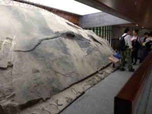
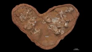
The ichthyosaur specimen with its stomach contents visible as a block that extrudes from its body. Credit: Ryosuke Motani
When paleontologists digging in a quarry in southwestern China uncovered the nearly complete skeleton of a giant, dolphin-like marine reptile known as an ichthyosaur, they didn’t expect to find another fossil in its stomach. This second skeleton belonged to a four-meter-long, lizard-like aquatic reptile known as a thalattosaur and is one of the longest fossils ever found in the stomach of a prehistoric marine reptile. While the researchers can’t say for sure whether the thalattosaur was scavenged or preyed upon, their work could be the oldest direct evidence that Triassic marine reptiles like ichthyosaurs—previously thought to be cephalopod feeders—were apex megapredators. The findings appear August 20th in the journal iScience.
“If you look across all the similar marine reptiles that lived in the age of dinosaurs, we’ve actually never found something articulated like this in the stomach,” says co-author Ryosuke Motani, a professor of paleobiology at the University of California, Davis. “Our ichthyosaur’s stomach contents weren’t etched by stomach acid, so it must have died quite soon after ingesting this food item. At first, we just didn’t believe it, but after spending several years visiting the dig site and looking at the same specimens, we finally were able to swallow what we were seeing.”
Because stomach contents are rarely found in marine fossils, researchers rely on tooth and jaw shapes to learn what prehistoric species may have eaten. While prehistoric apex predators are typically thought to have large teeth with sharp cutting edges, some modern predatory species like crocodiles use blunt teeth to consume large prey items with grasping force instead of cutting. Ichthyosaurs share these blunter teeth, but with no direct evidence of large prey consumption in these prehistoric marine reptiles, scientists believed that they fed on small prey like cephalopods.
However, the discovery of the giant thalattosaur in the stomach of the ichthyosaur found by Motani, Da-Yong Jiang, a paleontologist at Peking University in China, and their team suggests that this was not the case. “Now, we can seriously consider that they were eating big animals, even when they had grasping teeth,” says Motani. “It’s been suggested before that maybe a cutting edge was not crucial, and our discovery really supports that. It’s pretty clear that this animal could process this large food item using blunt teeth.”
While the researchers now know that the ichthyosaur could eat animals as large as the thalattosaur, they don’t know if it killed this individual, or simply scavenged it. “Nobody was there filming it,” says Motani. However, there is reason to believe this was not a case of scavenging: modern marine decomposition studies suggest that if left to decay, the thalattosaur’s limbs would disintegrate and detach before the tail. Instead, the researchers found the opposite in these fossils. The thalattosaur’s limbs were at least partially attached to its body in the stomach, while a disconnected tail was found many yards away, leading the researchers to believe it was ripped off and left behind by a predator like the ichthyosaur.
Whether or not the ichthyosaur killed its last meal, the fossil provides the oldest direct evidence that these giant marine reptiles consumed animals larger than humans. “We now have a really solid articulated fossil in the stomach of a marine reptile for the first time,” Motani says. “Before, we guessed that they must have eaten these big things, but now, we can say for sure that they did eat large animals. This also suggests that megapredation was probably more common than we previously thought.”
The team is still excavating the site where the pair of fossils were found, which has now been turned into a museum. “We’ve been digging in that particular quarry for more than ten years now, and still, new things are coming out,” says Motani. “At this point, it’s beyond our initial expectations, and we’ll just have to see what we’ll discover next.”
Reference:
iScience, Jiang et al.: “Evidence supporting predation of 4-meter marine reptile by Triassic megapredator.” DOI: 10.1016/j.isci.2020.101347
Note: The above post is reprinted from materials provided by Cell Press.
Artists impression of the dinosaur’s final moments. Credit: Trudie Wilson
A new study by Palaeontologists at the University of Southampton suggests four bones recently found on the Isle of Wight belong to new species of theropod dinosaur, the group that includes Tyrannosaurus rex and modern-day birds.
The dinosaur lived in the Cretaceous period 115 million years ago and is estimated to have been up to four metres long.
The bones were discovered on the foreshore at Shanklin last year and are from the neck, back and tail of the new dinosaur, which has been named Vectaerovenator inopinatus.
The name refers to the large air spaces in some of the bones, one of the traits that helped the scientists identify its theropod origins. These air sacs, also seen in modern birds, were extensions of the lung, and it is likely they helped fuel an efficient breathing system while also making the skeleton lighter.
The fossils were found over a period of weeks in 2019 in three separate discoveries, two by individuals and one by a family group, who all handed in their finds to the nearby Dinosaur Isle Museum at Sandown.
The scientific study has confirmed the fossils are very likely to be from the same individual dinosaur, with the exact location and timing of the finds adding to this belief.
Robin Ward, a regular fossil hunter from Stratford-upon-Avon, was with his family visiting the Isle of Wight when they made their discovery. He said: “The joy of finding the bones we discovered was absolutely fantastic. I thought they were special and so took them along when we visited Dinosaur Isle Museum. They immediately knew these were something rare and asked if we could donate them to the museum to be fully researched.”
James Lockyer, from Spalding, Lincolnshire was also visiting the Island when he found another of the bones. Also a regular fossil hunter, he said: “It looked different from marine reptile vertebrae I have come across in the past. I was searching a spot at Shanklin and had been told and read that I wouldn’t find much there. However, I always make sure I search the areas others do not, and on this occasion it paid off.”
Paul Farrell, from Ryde, Isle of Wight, added: “I was walking along the beach, kicking stones and came across what looked like a bone from a dinosaur. I was really shocked to find out it could be a new species.”
After studying the four vertebrae, paleontologists from the University of Southampton confirmed that the bones are likely to belong to a genus of dinosaur previously unknown to science. Their findings will be published in the journal Papers in Palaeontology, in a paper co-authored by those who discovered the fossils.
Chris Barker, a PhD student at the university who led the study, said: “We were struck by just how hollow this animal was — it’s riddled with air spaces. Parts of its skeleton must have been rather delicate.
“The record of theropod dinosaurs from the ‘mid’ Cretaceous period in Europe isn’t that great, so it’s been really exciting to be able to increase our understanding of the diversity of dinosaur species from this time.
“You don’t usually find dinosaurs in the deposits at Shanklin as they were laid down in a marine habitat. You’re much more likely to find fossil oysters or drift wood, so this is a rare find indeed.”
It is likely that the Vectaerovenator lived in an area just north of where its remains were found, with the carcass having washed out into the shallow sea nearby.
Chris Barker added: “Although we have enough material to be able to determine the general type of dinosaur, we’d ideally like to find more to refine our analysis. We are very grateful for the donation of these fossils to science and for the important role that citizen science can play in palaeontology.”
The Isle of Wight is renowned as one of the top locations for dinosaur remains in Europe, and the new Vectaerovenator fossils will now go on display at the Dinosaur Isle Museum at Sandown, which houses an internationally important collection.
Museum curator, Dr Martin Munt, said: “This remarkable discovery of connected fossils by three different individuals and groups will add to the extensive collection we have and it’s great we can now confirm their significance and put them on display for the public to marvel at.
“We continue to undertake public field trips from the museum and would encourage anyone who finds unusual fossils to bring them in so we can take a closer look. However, fossil hunters should remember to stick to the foreshore, and avoid going near the cliffs which are among the most unstable on the Island.”
Isle of Wight Council Cabinet member for environment and heritage, Councillor John Hobart, said: “This is yet another terrific fossil find on the Island which sheds light on our prehistoric past — all the more so that it is an entirely new species. It will add to the many amazing items on display at the museum.”
Reference:
Chris Barker et al. A highly pneumatic ‘mid Cretaceous’ theropod from the British Lower Greensand. Papers in Palaeontology, 2020
The trilobite Aulacopleura kionickii (Barrande, 1846), size: c 1cm. Credit: Brigitte Schoenemann.
An exquisitely well preserved 429-million-year-old eye from a marine creature that went extinct before dinosaurs even existed had vision comparable to modern-day bees and dragonflies, researchers said Thursday.
Fossilized trilobites, formidable-looking arthropods with segmented bodies and sturdy exoskeletons, are found all over the world.
The creatures crawled across ancient seabeds during the Paleozoic Era, which came to and end about 252 million years ago during the “great dying”, an extinction event that wiped out 95 percent of life on Earth.
The specimen detailed in the journal Scientific Reports is just one to two millimeters high and has two protruding semi-oval eyes on the back of its head, one of which had broken off.
Using digital microscopy, researchers from Germany and Britain found internal structures remarkably similar to those of the compound eyes of modern insects and crustaceans, which see through a honeycomb of small lenses each with a separate visual unit that takes in a small patch of light.
“In this little trilobite, the compound eye is almost the same as that of bees, dragonflies of today, and many modern diurnal (day active) crustaceans,” said co-author Brigitte Schoenemann, of the zoology department at the University of Cologne.
“So this system seems to be very efficient, very old,” she told AFP.
While it was previously known that trilobites had these compound eyes, older specimens had “slit formed” eyes, “just scanning the horizon” and without lenses on the visual units.
“In this trilobite the view widens, the eye also looks partly upwards,” she said.
Human eyes have a single lens and tens of millions of light-sensitive cells, giving an advanced level of image formation.
Schoenemann said that in a compound eye, each visual unit works separately to provide a single pixel, “like in a computer graphic”.
The trilobite studied had just 200 of these, giving it a mosaic vision that would have enabled it to see “obstacles, shelters” and most importantly, predators like the ancient cephalopod—distant ancestor of the nautilus and octopus.
For comparison, she said the honey bee has several thousand of these “pixels”, while a dragonfly has up to 30,000 per eye.
“So the resolution differs, but not the functional principle.”
Because each of the lenses in the trilobite’s eye was small (35 micrometers in diameter), the researchers concluded that it lived in shallow, light-flooded waters, like certain modern-day shore crabs.
‘Breathtaking’
The trilobite in question was first discovered in 1846 near Lodenice, in the Czech Republic.
Schoenemann said the specimen was not otherwise unusual, suggesting that further study of existing fossils may uncover delicate structures that until recently were assumed to have disappeared over time.
“I simply liked this trilobite with its big head, and big eyes. But when I looked through the microscope, it was breathtaking what I saw,” she said.
“Not long ago people still thought that in fossils just teeth, bones and such could be preserved, but never cellular structures. This has changed obviously.”
Trilobites first started to appear during the so-called Cambrian Explosion—a surge in biological diversity more than half-a-billion years ago—and they populated the oceans for some 250 million years.
Dinosaurs emerged later and survived for some 180 million years.
A fossilized meandering grazing trail from the Cambrian era. Credit: Luis Buatois
If you could dive down to the ocean floor nearly 540 million years ago just past the point where waves begin to break, you would find an explosion of life — scores of worm-like animals and other sea creatures tunneling complex holes and structures in the mud and sand — where before the environment had been mostly barren.
Thanks to research published today in Science Advances by a University of Saskatchewan (USask)-led international research team, this rapid increase in biodiversity — one of two such major events across a 100-million-year timespan 560 to 443 million years ago — is part of a clearer picture emerging of Earth’s ancient oceans and life in them.
“We can see from the trace fossils — tracks, trails, borings, and burrows animals left behind — that this particular environment of the ocean floor, the offshore, served as a ‘crucible’ for life,” said USask paleobiologist Luis Buatois, lead author of the article. “Over the next millions of years, life expanded from this area outwards into deeper waters and inwards into shallower waters.”
The research is the culmination of over 20 years of work from Buatois and the team which examined hundreds of rock formations in locations across every continent.
“Until now, these two events — the Cambrian Explosion and the Great Ordovician Biodiversification Event — have been understood mostly through the study of body fossils — the shells, carapaces and the bones of ancient sea creatures,” said Buatois. “Now we can confidently say that these events are also reflected in the trace fossil record which reveals the work of those soft-bodied creatures whose fleshy tissues rot very quickly and so are only very rarely preserved.”
For the first time, the team has shown evidence of animals actively “engineering” their ecosystem — through the construction of abundant and diverse burrows on the sea floor of the world’s oceans in this ancient time.
“Never underestimate what animals are capable of doing,” said USask paleobiologist Gabriela Mángano, co-author of the paper. “They can modify their physical and chemical environment, excluding other animals or allowing them to flourish by creating new resources. And they were definitely doing all these things in these ancient seas.”
The trace fossil-producing animals’ engineering efforts may have laid the foundation for greater diversity in marine life. The researchers identified a 20-million-year time lag during the Cambrian Explosion (the time when most of the major groups of animals first appear in the fossil record) between diversification in trace fossils and in animal body fossils, suggesting the later animals exploited changes which enabled them to diversify even more.
The research also helps resolve a big question from the geochemical record, which indicated much of the ancient ocean was depleted of oxygen and unsuitable for life. Like oceans today, the Cambrian ocean had certain areas that were full of life, while others lacked the necessary conditions to support it.
“The fact that trace fossil distribution shows that there were spots where life flourished adjacent to others devoid of animal activity all through the early Cambrian period is a strong argument in favor of the idea that zones with enough oxygen to sustain a diversity of animals co-existed with oxygen-depleted waters in deeper areas,” said Mángano. “It’s a situation similar to what happens in modern oceans with oxygen minimum zones in the outer part of the continental shelf and the upper part of the continental slope, but oxygenated ones in shallower water.”
The research could provide new insights from an evolutionary perspective into the importance of extensive rock formations of a similar vintage found in Canada and elsewhere, and help society to prepare for coming challenges.
“Understanding changes that took place early in the history of our planet may help us to face present challenges in modern oceans, particularly with respect to oxygen changes,” said Buatois.
Other members of the team are: USask PhD student Kai Zhou, University of Portsmouth researcher Nic Minter, Senckenberg am Meer institute (Hamburg) researcher Max Wisshak, College of Wooster (Ohio) paleontologist Mark Wilson, and statistician Ricardo Olea of the United States Geological Survey.
The research was funded by grants from Canada’s Natural Sciences and Engineering Research Council awarded to Buatois and Mángano.
Reference:
Luis A. Buatois, M. Gabriela Mángano, Nicholas J. Minter, Kai Zhou, Max Wisshak, Mark A. Wilson, Ricardo A. Olea. Quantifying ecospace utilization and ecosystem engineering during the early Phanerozoic—The role of bioturbation and bioerosion. Science Advances, 2020; 6 (33): eabb0618 DOI: 10.1126/sciadv.abb0618
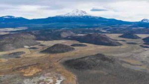
Northern California’s Mount Shasta is among the largest and most active volcanoes in the Cascade Range.
Volcanic eruptions in the Cascade Range of the Pacific Northwest over the last 2.6 million years are more numerous and closely connected to subsurface signatures of currently active magma than commonly thought, according to newly published research.
A synthesis of volcanic vents on the surface and data that probes the structure and composition of the crust to a depth of 20 kilometers (12.4 miles) makes clear new connections between surface and subsurface evidence of past volcanic eruptions. The activity has stretched far beyond the 11 well known stratovolcanoes lining the Cascade Arc between northern California and northern Washington.
The study, led by University of Oregon scientists, catalogued almost 3,000 volcanoes associated with the mountain range. It was published July 13 in the journal Geology.
The research reveals new details about the complex and time-evolving patterns of rising magma in the region, said study co-author Leif Karlstrom, a professor in the UO Department of Earth Sciences and Oregon Center for Volcanology.
“Anyone who has ever flown between San Francisco and Seattle has probably marveled at the massive stratovolcanoes lined up between northern California and southern British Columbia,” he said. “Remarkably, these landforms represent less than 1 percent of the volcanoes in the Cascades that have erupted in the geologically recent past.”
The three-member research team examined 2,835 vents. They used freely available satellite-derived 3D digital terrain models to update estimates of eruption rates and synthesize subsurface observations over recent decades to map where signs of active magma in the crust correlates with edifices on the surfaces around the region’s volcanos.
Edifices refer to the main portion of volcanoes built by erupted lava, rock projectiles, mud and debris flows, and mixture of rock fragments, gas and ash.
The 3D models allowed the research team to associate volcanic edifices with underlying seismic velocities, heat flow, gravity and deformation that are sensitive to the presence of magma, Karlstrom said. The work, he added, showed where surface vents seem to overlay currently active magma transport structures in the crust.
“Previous studies have analyzed single volcanoes or volcanic clusters with satellite data, but this is the first study to constrain volcano geometries over an entire arc in a self-consistent manner,” said the study’s lead author, Daniel O’Hara, a UO doctoral student. “We estimate that volcanic edifices represent about 50 percent of total volcanic output during the time-period we examined.”
The research, he added, indicated a systematic decrease in the strength of these relationships, suggesting that eruptions as well as their underlying plumbing systems have migrated during the past 2.6 million years.
The National Science Foundation-funded research can help guide more in-depth studies of distributed volcanic vents and in assessing hazards and risks to people and infrastructure, said co-author David W. Ramsey of the U.S. Geological Survey’s Cascades Volcano Observatory in Vancouver, Washington.
Distributed volcanic vents are associated with small cinder cones that cover much of the central Oregon Cascades, and area such as the Boring Lava Field in the city of Portland and the Medicine Lake volcano in California.
“This research used a consistent methodology to analyze volcanic vents spanning the entire U.S. Cascade Range over the last 2.6 million years,” Ramsay said. “It helps to highlight recently active volcanic vents, particularly in central Oregon and northern California, and shows that the locations of potential future eruptions are not limited to the snow-capped stratovolcanoes on the horizon.”
The region’s major stratovolcanoes stretch along the junction of the Juan de Fuca and North American plates. From north to south, they are Mount Baker, Glacier Peak, Mount Rainier, Mount St. Helens, Mount Adams, Mount Hood, Mount Jefferson, Three Sisters, Crater Lake/Mount Mazama, Mount Shasta and Lassen Peak.
Reference:
David W. Ramsey, Leif Karlstrom, Daniel O’Hara. Time-evolving surface and subsurface signatures of Quaternary volcanism in the Cascades arc. Geology, 2020; DOI: 10.1130/G47706.1
Scientists have tracked a ‘boomerang’ earthquake in the ocean for the first time, providing clues about how they could cause devastation on land.
Earthquakes occur when rocks suddenly break on a fault — a boundary between two blocks or plates. During large earthquakes, the breaking of rock can spread down the fault line. Now, an international team of researchers have recorded a ‘boomerang’ earthquake, where the rupture initially spreads away from initial break but then turns and runs back the other way at higher speeds.
The strength and duration of rupture along a fault influences the among of ground shaking on the surface, which can damage buildings or create tsunamis. Ultimately, knowing the mechanisms of how faults rupture and the physics involved will help researchers make better models and predictions of future earthquakes, and could inform earthquake early-warning systems.
The team, led by scientists from the University of Southampton and Imperial College London, report their results today in Nature Geoscience.
While large (magnitude 7 or higher) earthquakes occur on land and have been measured by nearby networks of monitors (seismometers), these earthquakes often trigger movement along complex networks of faults, like a series of dominoes. This makes it difficult to track the underlying mechanisms of how this ‘seismic slip’ occurs.
Under the ocean, many types of fault have simple shapes, so provide the possibility get under the bonnet of the ‘earthquake engine’. However, they are far from large networks of seismometers on land. The team made use of a new network of underwater seismometers to monitor the Romanche fracture zone, a fault line stretching 900km under the Atlantic near the equator.
In 2016, they recorded a magnitude 7.1 earthquake along the Romanche fracture zone and tracked the rupture along the fault. This revealed that initially the rupture travelled in one direction before turning around midway through the earthquake and breaking the ‘seismic sound barrier’, becoming an ultra-fast earthquake.
Only a handful of such earthquakes have been recorded globally. The team believe that the first phase of the rupture was crucial in causing the second, rapidly slipping phase.
First author of the study Dr Stephen Hicks, from the Department of Earth Sciences and Engineering at Imperial, said: “Whilst scientists have found that such a reversing rupture mechanism is possible from theoretical models, our new study provides some of the clearest evidence for this enigmatic mechanism occurring in a real fault.
“Even though the fault structure seems simple, the way the earthquake grew was not, and this was completely opposite to how we expected the earthquake to look before we started to analyse the data.”
However, the team say that if similar types of reversing or boomerang earthquakes can occur on land, a seismic rupture turning around mid-way through an earthquake could dramatically affect the amount of ground shaking caused.
Given the lack of observational evidence before now, this mechanism has been unaccounted for in earthquake scenario modelling and assessments of the hazards from such earthquakes. The detailed tracking of the boomerang earthquake could allow researchers to find similar patterns in other earthquakes and to add new scenarios into their modelling and improve earthquake impact forecasts.
The ocean bottom seismometer network used was part of the PI-LAB and EUROLAB projects, a million-dollar experiment funded by the Natural Environment Research Council in the UK, the European Research Council, and the National Science Foundation in the US.
Reference:
Stephen P. Hicks, Ryo Okuwaki, Andreas Steinberg, Catherine A. Rychert, Nicholas Harmon, Rachel E. Abercrombie, Petros Bogiatzis, David Schlaphorst, Jiri Zahradnik, J-Michael Kendall, Yuji Yagi, Kousuke Shimizu, Henriette Sudhaus. Back-propagating supershear rupture in the 2016 Mw 7.1 Romanche transform fault earthquake. Nature Geoscience, 2020; DOI: 10.1038/s41561-020-0619-9
Blue diamond is a type of diamond which exhibits all of the mineral ‘s inherent properties except with the stone’s additional element of blue colour. They are colored blue by trace amounts of boron which contaminate the structure of the crystalline lattice. Blue diamonds belong to a diamond subcategory called fancy color diamonds, the generic name for diamonds displaying intense colour. Blue diamonds range from Flawless to Included in grade as is the case with white diamonds.
The diamond, named “The Oppenheimer Blue” in honor of its previous owner, sold for a final price of $57.5 million. While the Pink Star diamond broke its record for most expensive jewel ever sold, the blue diamond holds the record for the most valuable price per carat at $3.93 million.
2. Jadeite – $3 million per carat
Jadeite
Jadeite is the purest, rarest, and most vivid gemstone in the Jade family. Jadeite is a pyroxene mineral with composition NaAlSi2O6. It is monoclinic. It has a Mohs hardness of about 6.5 to 7.0 depending on the composition. The mineral is dense, with a specific gravity of about 3.4.
The “Hutton-Midivani Necklace”, which consists of 27 large, top quality jadeite beads, did just that. After twenty minutes of intense bidding from eight potential buyers, the piece sold for $27.44 million to Cartier, the original designer of the necklace.
3. Pink Diamond – $1.19 million per carat
Australia’s largest pink diamond Source: Rio Tinto
Pink diamonds are extremely rare. Only 0.0001% of the diamonds in existence are pink. It is a gemstone that would give beauty and harmony to the world. Just like white diamonds, pink diamonds can range from flawless to (heavily) included. The Pink Star is the only pink diamond in the world that is completely flawless.
In 2017, a stunning pink diamond weighing 59.60-carats was sold at a Sotheby’s auction in Hong Kong for a record-breaking $71.2 million. That’s $1.19 million per carat. Known as the “Pink Star” diamond, it’s the largest Fancy Vivid Pink diamond ever graded as Internally Flawless by the Gemological Institute of America.
4. Red Diamond – $1,000,000 per carat
Very rare Argyle Cardinal Fancy Red diamond
Red Diamond is a diamond with the same mineral properties as colorless diamonds, displaying red color. They are commonly known as the world’s most expensive and rare color of diamonds, more so than pink diamonds or blue diamonds.
It is like pink diamonds, are highly debated as to the source of their color, but the gemological community most frequently attributes both colors to gliding atoms in the structure of the diamond as it undergoes tremendous pressure during its formation.
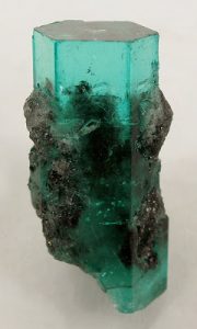
5. Emerald – $305,000 per carat
Emerald
Emerald is a gemstone and a variety of the mineral beryl (Be3Al2(SiO3)6) colored green by trace amounts of chromium and sometimes vanadium. Beryl has a hardness of 7.5–8 on the Mohs scale. Most emeralds are highly included, so their toughness (resistance to breakage) is classified as generally poor.
At the Christie’s auction, it was purchased for $5.5 million, or $305,000 per carat. That made it the most expensive emerald per carat ever sold.
6. Taaffeite – $35,000 per carat
Taaffeite
Taaffeite BeMgAl4O8 is a mineral named after its discoverer Richard Taaffe (1898–1967) who found the first sample, a cut and polished gem, in Dublin , Ireland, in October 1945. As such, this is the only gemstone that was first identified from a faceted stone. Most of the gem pieces had been misidentified as spinel, prior to Taaffe. It was only known in a few samples for many years after, and it is still one of the world’s rarest gemstone minerals.
Chemical and X-ray analysis confirmed taaffeite ‘s main constituents as beryllium, magnesium and aluminum in 1951, making taaffeite the first mineral to contain both beryllium and magnesium as essential components.
The confusion between spinel and taaffeite is understandable, as certain structural characteristics in both are identical. Anderson et al., classified taaffeite as a spinel-to-chrysoberyl intermediate mineral. Unlike spinel, taaffeite displays the double refraction property which allows distinguishing between these two minerals.
7. Grandidierite – $20,000 per carat
Grandidierite is a rare mineral originally discovered in southern Madagascar in 1902. The mineral was named to honor French explorer Alfred Grandidier (1836–1912) who studied Madagascar’s natural history.
The more iron (Fe) they contain, the more grandidierites appear bluer in colour. The Fe-analog (Fe, Mg) to grandidierite (Mg, Fe) is a recently discovered gemstone, blue ominelite.
Grandidierites display strong trichroic pleochroism. That means that depending on the viewing angle, they can show three different colors: dark blue-green, colorless (sometimes very light yellow), or dark green.
8. Serendibite – $18,000 per carat
Serendibite
Serendibite is an extremely rare mineral of silicate first discovered by Dunil Palitha Gunasekera in Sri Lanka in 1902 and named after Serendib, the old Arabic name for Sri Lanka.
The mineral is found in skarns associated with boron metasomatism of carbonate rocks where intruded by granite. Minerals occurring with serendibite include diopside, spinel, phlogopite, scapolite, calcite, tremolite, apatite, grandidierite, sinhalite, hyalophane, uvite, pargasite, clinozoisite, forsterite, warwickite and graphite.
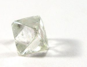
9. Diamond – $15,000 per carat
Diamond
In mineralogy, diamond is a metastable allotrope of carbon, where the carbon atoms are arranged in a variation of the face-centered cubic crystal structure called a diamond lattice. Diamond is less stable than graphite, but the conversion rate from diamond to graphite is negligible at standard conditions.
Diamond is renowned as a material with superlative physical qualities, most of which originate from the strong covalent bonding between its atoms. In particular, diamond has the highest hardness and thermal conductivity of any bulk material. Those properties determine the major industrial application of diamond in cutting and polishing tools and the scientific applications in diamond knives and diamond anvil cells.
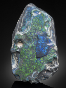
10. Black Opal – $15,000 per carat
Black Opal
Australian black opals are the most valuable and widely known type of opal. Black opal is characterised by a dark body tone which can range from dark grey to jet black. (See the following chart). However this refers only to the general body tone of the stone, and is not related to the rainbow or spectral colours present in the opal. Some people expect a black opal to be completely black (in which case it would be completely worthless).
Unlike ordinary opals, black opals have carbon and iron oxide trace elements present, which cause the unusual darkness of the stone. Because of their dark body tone, the rainbow colours in a black opal stand out much better than lighter opals.
By comparison, black opals are the most valuable form of opal – due to their dark body tone and the resulting vibrant play of colour. Top of the range gem quality black opal can fetch prices up to AUD $15,000 per carat. However, just because an opal is black doesn’t make it valuable. There are many factors including brightness and pattern which determine the overal value of opal. Read more in our article on the value of opal.
Alexandrite (BeAl2O4) is a type of chrysoberyl found during the 1830’s in the Ural Mountains, Russia. You may have seen this mineral ‘s incredibly changing color where it seems to be emerald in light and ruby red in darkness.
The variety of alexandrite shows a change of color depending on the nature of ambient lighting, called metamerism. Metamerism is the phenomenon of an observed change in color from greenish to reddish with a change in source illumination. Alexandrite results from the small-scale replacement of aluminum by chromium ions in the crystal structure, which causes intense light absorption over a narrow range of wavelengths in the yellow region (580 nm) of the visible light.
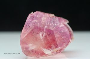
12. Red Beryl – $10,000 per carat
Red Beryl Crystals from Utah. Credit: Treasure Mountain Mining
Red beryl (formerly known as “bixbite” and marketed as “red emerald” or “scarlet emerald” but notes that both latter terms involving “Emerald” terminology are now prohibited under the Federal Trade Commission Regulations in the United States) is a red variety of beryl. It was first described at Maynard ‘s Claim (Pismire Knolls), Thomas Range, Juab County, Utah, for an occurrence, its type locality, in 1904.
Red beryl is very rare and has been reported only from a handful of locations: Wah Wah Mountains, Beaver County, Utah; Paramount Canyon and Round Mountain, Sierra County, New Mexico, although the latter locality does not often produce gem grade stones; and Juab County, Utah.
13. Musgravite – $6,000 per carat
This 0.86 ct gray musgravite displays an unusual iridescent phenomenon that is clearly visible in the table facet. Photo by Kevin Schumacher.
Musgravite or magnesiotaaffeite-6N’3S is a rare oxide mineral used as a gemstone. Its type locality is the Ernabella Mission, Musgrave Ranges, South Australia, for which it was named following its discovery in 1967. It is a member of the taaffeite family of minerals, and its chemical formula is Be(Mg, Fe, Zn)2Al6O12. Its hardness is 8 to 8.5 on the Mohs scale. Due to its rarity, the mineral can sell for roughly USD$35,000 per carat.
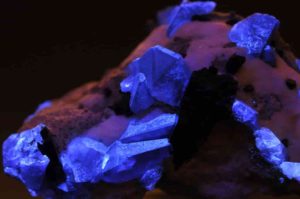
14. Benitoite – $4,000 per carat
Benitoite crystals under UV light. Dallas Gem Mine (Benitoite Mine ; Benitoite Gem Mine ; Gem Mine), Dallas Gem Mine area, San Benito River headwaters area, New Idria District, Diablo Range, San Benito Co., California, USA. Photo Credit: Parent Géry
Benitoite is a rare blue titanium cyclosilicate barium, found in serpentinite altered by hydrothermal conditions. It forms at convergent plate boundaries in low temperature , high pressure environments typical of the subduction zones. Benitoite fluoresces under ultraviolet light of short wave, which appears bright blue to bluish white in colour. The more rarely seen clear to white benitoite crystals fluoresce red under long-wave UV light.
Benitoite typically occurs with an unusual set of minerals, along with minerals that make up its host rock. Frequently associated minerals include: natrolite, neptunite, joaquinite, serpentine and albite.
Benitoite is a rare mineral found in very few locations including San Benito County, California, Japan and Arkansas. In the San Benito occurrence, it is found in natrolite veins within glaucophane schist within a serpentinite body. In Japan, the mineral occurs in a magnesio-riebeckite-quartz-phlogopite-albite dike cutting a serpentinite body.
15. Poudretteite – $3,000 per carat
Poudretteite
Poudretteite is an extremely rare mineral and gemstone that was first discovered as minute crystals in Mont St. Hilaire, Quebec, Canada, during the 1960s. The mineral was named for the Poudrette family because they operated a quarry in the Mont St. Hilaire area where poudretteite was originally found.
16. Fire Opal – $2,300 per carat
Multicolor rough crystal opal from Coober Pedy, South Australia, expressing nearly every color of the visible spectrum. Credit: Dpulitzer
Fire opal is a translucent opal with warm body colors ranging from yellow to orange to gold. Even though it usually doesn’t show any color play, sometimes a stone will show bright green flashes. Querétaro in Mexico is the most popular supplier of fire opals; these opals are commonly referred to as Mexican fire opals.
Opal is a hydrated amorphous type of silica (SiO2·nH2O); its water content can differ by weight from 3 to 21%, but is typically between 6 and 10%. It is known as a mineraloid because of its amorphous nature, unlike crystalline types of silica, classified as minerals. It is deposited at a relatively low temperature and can occur in nearly any rock fissures, most commonly found in limonite, sandstone, rhyolite, marl, and basalt. Opal is Australia’s largest gemstone.
17. Jeremejevite – $2,000 per carat
Jeremejevite
Jeremejevite is a rare aluminium borate mineral with variable fluoride and hydroxide ions. Its chemical formula is Al6(BO3)5(F,OH)3.
It was first described in 1883 for an occurrence on Mt. Soktui, Nerschinsk district, Adun-Chilon Mountains, Siberia. It was named after Russian mineralogist Pavel Vladimirovich Eremeev (Jeremejev, German) (1830–1899).
It occurs as a late hydrothermal phase in granitic pegmatites in association with albite, tourmaline, quartz and rarely gypsum. It has also been reported from the Pamir Mountains of Tajikistan, Namibia and the Eifel district, Germany.
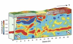
The Dipping Moho is a sign of one continent being thrust over another. Credit: IGG
Today, the entire globe is broken up into tectonic plates that are shifting past each other, causing the continents to drift slowly but steadily. But this has not always been the case.
The earliest evidence for plate tectonic features which could have been localized does not signify when plate tectonics became a global phenomenon. So, when did plate tectonics go global?
A research team led by Dr. Wan Bo from the Institute of Geology and Geophysics (IGG) of the Chinese Academy of Sciences has revealed that plate tectonics went global 2 billion years ago. The study was published in Science Advances on August 5.
The Earth is 4.56 billion years old. Although geologists have argued for plate tectonics being operational as early as 4 billion years ago, this is the first study to provide global evidence.
Subduction, the pushing of one plate beneath another when two plates converge, is one of the telltale signs of plate tectonics. Usually dense ocean crust is pushed back into the deep Earth as continents ride high. But when two continents collide, something is gonna happen.
The best known continental collision on Earth today is the Himalayan Mountains: as India slams into Eurasia, the smaller continent of India is pushed beneath the megacontinent. Geologists can image this collision with seismology: waves from earthquakes show Eurasia ramping up on top of India.
The IGG researchers designed a seismological study to investigate the structure of ancient crust at one of the oldest and most stable region, Ordos. Now, it is mostly flat without any high mountains. However, they found essentially the same deep structure. “Even though the dipping structure we found was identical to what we see in the Himalaya today, what we were looking at was 2 billion years old,” said Dr. Wan.
On top of their evidence of ancient subduction in China, the researchers demonstrated that several continents with seismological studies showed similar dipping structures 2 billion years ago too.
“The authors do a very nice job of describing their results and placing them into a larger scale context,” said Prof. Peter Cawood, an expert in ancient plate tectonics at Monash University who wasn’t involved in the study.
Even though subduction may have occurred here or there on Earth early on, it was not until 2 billion years ago that we can say plate tectonics became a global network.
“It’s like the invention of the world wide web,” said co-author Dr. Ross Mitchell of IGG. “Even though the internet existed in some form or another for decades, it wasn’t until the 1990s that the Information Age began.” So it was with plate tectonics.
Seismic evidence of subduction from six continents at this age is interpreted as the oldest evidence of global plate tectonics. The continental connections identified can be linked in a plate network that resulted in the assembly of Nuna, likely Earth’s first supercontinent.
“Immediately following plate tectonics going global, Earth formed arguably its first supercontinent,” said Dr. Mitchell. “This coincidence is too compelling to ignore.”
Reference:
“Seismological evidence for the earliest global subduction network at 2 Ga” Science Advances (2020). DOI: 10.1126/sciadv.abc5491
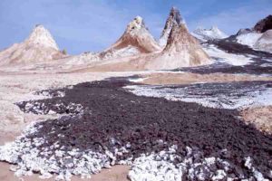
Ol Doinyo Lengai volcano in Tanzania, a source of carbonate-rich magma. Photo by Tobias Fischer, University of New Mexico, 2005 / Courtesy of the National Science Foundation.
Geologists from Florida State University’s Department of Earth, Ocean and Atmospheric Science have discovered how carbon-rich molten rock in the Earth’s upper mantle might affect the movement of seismic waves.
The new research was coauthored by EOAS Associate Professor of Geology Mainak Mookherjee and postdoctoral researcher Suraj Bajgain. Findings from the study were published in the journal Proceedings of the National Academy of Sciences .
“This research is quite important since carbon is a crucial constituent for the habitability of the planet, and we are making strides to understand how solid earth may have played a role in storing and influencing the availability of carbon in the Earth’s surface,” Mookherjee said. “Our research gives us a better understanding of the elasticity, density and compressibility of these rocks and their role in Earth’s carbon cycle.”
Carbon, one of the primary building blocks for life, is widely distributed throughout the Earth’s upper mantle and is mostly stored in forms of carbonate minerals as accessory minerals in mantle rocks. When carbonate-rich magma erupts on the surface, it is notable for its unique, mud-like appearance. These types of eruptions occur at specific locations around the world, such as at the Ol Doinyo Lengai volcano in Tanzania.
Experts believe that the presence of carbonates in rocks significantly lowers the temperature at which they melt. Carbonates that sink to the Earth’s interior, via a process known as subduction, likely cause this low-degree melting of the Earth’s upper mantle rocks, which plays an important role in the planet’s deep carbon cycle.
“Earth’s mantle has less free oxygen available at increasing depths,” Mookherjee said. “As the mantle upwells through a process of mantle convection, the slowly moving rocks that were reduced, or had less oxygen, at a greater depth become progressively more oxidized at shallower depth. The carbon in the mantle is likely to be reduced deeper in the Earth and get oxidized as the mantle upwells.”
This change in depth-dependent oxidation state is likely to cause melting of mantle rocks, a process called redox melting, which could produce carbon-rich molten rock, also known as melts. These melts are likely to affect the physical property of a rock, which can be detected using geophysical probes such as seismic waves, he said.
Prior to this study, geologists had poor knowledge of the elastic properties of these carbonate-induced partial melts, which made them difficult to directly detect.
One set of clues that geologists use to better understand their science are measurements of seismic waves as they move through the layers of the Earth. A type of seismic wave known as a compressional wave is faster than another type known as a shear wave, but at depths of around 180 to 330 kilometers into the Earth, the ratio of their speeds is even higher than is typical.
“This elevated ratio of compressional waves to the shear waves has been a puzzle, and using the findings from our study, we are able to explain this perplexing observation,” Mookherjee said.
Minor quantities of carbon-rich melts, approximately 0.05 percent, might be dispersed pervasively through the Earth’s deep upper mantle, and that may lead to the elevated ratio of compressional to shear sound velocity, researchers explained.
To conduct the study, researchers took high-pressure ultrasonic measurements and density measurements on cores of the carbonate mineral dolomite. These experiments were complemented by theoretical simulations to provide a new understanding of the fundamental physical properties of carbonate melts.
“We have been trying to understand the elastic and transport properties of aqueous fluids, silicate melt and metallic melt properties, to gain better insight into the mass of volatiles stored in the deep solid earth,” Bajgain said.
These findings mean the partially molten rocks in the mantle could hold as much as 80 to 140 parts per million of carbon, which would be 20 to 36 million gigatons of carbon in the deep upper mantle region, making it a substantial carbon reservoir. In comparison, Earth’s atmosphere contains just over 410 ppm of carbon, or around 870 gigatons.
Reference:
Man Xu, Zhicheng Jing, Suraj K. Bajgain, Mainak Mookherjee, James A. Van Orman, Tony Yu, Yanbin Wang. High-pressure elastic properties of dolomite melt supporting carbonate-induced melting in deep upper mantle. Proceedings of the National Academy of Sciences, 2020; 202004347 DOI: 10.1073/pnas.2004347117
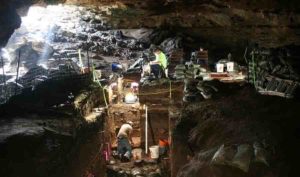
Workers excavating Hall’s Cave in Central Texas. Image Courtesy of Michael Waters
Ancient sediment found in a central Texas cave appears to solve the mystery of why the Earth cooled suddenly about 13,000 years ago, according to a research study co-authored by a Texas A&M University professor.
Michael Waters, director of The Center for The Study of the First Americans and Distinguished Professor at Texas A&M University, and colleagues from Baylor University and the University of Houston have had their work published in Science Advances.
Some researchers believed the event — which cooled the Earth by about 3 degrees Centigrade, a huge amount — was caused by an extraterrestrial impact with the Earth, such as a meteor collision.
But Waters and the team found that the evidence left in layers of sediment in Hall’s Cave were almost certainly the result of volcanic eruptions.
Waters said that Hall’s Cave, located in the Texas hill country, has a sediment record extending over 20,000 years and he first began researching the cave in 2017.
“It is an exceptional record that offers a unique opportunity for interdisciplinary cooperation to investigate a number of important research questions,” he said.
“One big question was, did an extraterrestrial impact occur near the end of the last ice age, about 13,000 years ago as the ice sheets covering Canada were melting, and cause an abrupt cooling that thrust the northern hemisphere back into the ice age for an extra 1,200 years?”
Waters and the team found that within the cave are layers of sediment, first identified by Thomas Stafford (Stafford Research Laboratories, Colorado), that dated to the time of the proposed impact that could answer the question and perhaps even identify the trigger that started the ancient cold snap.
The event also likely helped cause the extinction of large mammals such as mammoth, horse and camel that once roamed North America.
“This work shows that the geochemical signature associated with the cooling event is not unique but occurred four times between 9,000 and 15,000 years ago,” said Alan Brandon, professor of geosciences at University of Houston and head of the research team.
“Thus, the trigger for this cooling event didn’t come from space. Prior geochemical evidence for a large meteor exploding in the atmosphere instead reflects a period of major volcanic eruptions.
“I was skeptical,” Brandon said. “We took every avenue we could to come up with an alternative explanation, or even avoid, this conclusion. A volcanic eruption had been considered one possible explanation but was generally dismissed because there was no associated geochemical fingerprint.”
After a volcano erupts, the global spread of aerosols reflects incoming solar radiation away from Earth and may lead to global cooling post eruption for one to five years, depending on the size and timescales of the eruption, the team said.
“The Younger Dryas, which occurred about 13,000 years ago, disrupted distinct warming at the end of the last ice age,” said co-author Steven Forman, professor of geosciences at Baylor.
The Earth’s climate may have been at a tipping point at the end of Younger Dryas, possibly from the ice sheet discharge into the North Atlantic Ocean, enhanced snow cover and powerful volcanic eruptions that may have in combination led to intense Northern Hemisphere cooling, Forman said.
“This period of rapid cooling coincides with the extinction of a number of species, including camels and horses, and the appearance of the Clovis archaeological tradition,” said Waters.
Brandon and fellow University of Houston scientist Nan Sun completed the isotopic analysis of sediments collected from Hall’s Cave. They found that elements such as iridium, ruthenium, platinum, palladium and rhenium were not present in the correct proportions, meaning that a meteor or asteroid could not have caused the event.
“The isotope analysis and the relative proportion of the elements matched those that were found in previous volcanic gases,” said Sun, lead author of the report.
Volcanic eruptions cause their most severe cooling near the source, usually in the year of the eruption, with substantially less cooling in the years after the eruption, the team said.
The Younger Dryas cooling lasted about 1,200 years, “so a sole volcanic eruptive cause is an important initiating factor, but other Earth system changes, such as cooling of the oceans and more snow cover were needed to sustain this colder period, “Forman said.
Waters added that the bottom line is that “the chemical anomalies found in sediments dating to the beginning of the Younger Dryas are the result of volcanism and not an extraterrestrial impact.”
Reference:
N. Sun, A. D. Brandon, S. L. Forman, M. R. Waters and K. S. Befus. Volcanic origin for Younger Dryas geochemical anomalies ca. 12,900 cal B.P.. Science Advances, 2020 DOI: 10.1126/sciadv.aax8587
Note: The above post is reprinted from materials provided by Texas A&M University. Original written by Keith Randall.
A lizard-like creature whose ancestors once roamed the Earth with dinosaurs and today is known to live for longer than 100 years may hold clues to a host of questions about the past and the future.
In a study published Aug. 5 in Nature, an interdisciplinary, international team of researchers, in partnership with Māori tribe Ngātiwai, sequenced, assembled and analyzed the complete genome of the Sphenodon punctatus, or the tuatara, a rare reptile whose ancestors once roamed the earth with dinosaurs. It hasn’t changed much in the 150 million to 250 million years since then.
“We found that the tuatara genome has accumulated far fewer DNA substitutions over time than other reptiles, and the molecular clock for tuataras ticked at a much slower speed than squamates, although faster than turtles and crocodiles, which are the real molecular slowpokes,” said co-author Marc Tollis, an assistant professor in the School of Informatics, Computing, and Cyber Systems at Northern Arizona University. “This means in terms of the rate of molecular evolution, tuataras are kind of the Toyota Corolla — nothing special but very reliable and persistently ticking away over hundreds of millions of years.”
Tuatara have been out on their own for a staggering amount of time, with prior estimates ranging from 150-250 million years, and with no close relatives the position of tuatara on tree of life has long been contentious. Some argue tuatara are more closely related to birds, crocodiles and turtles, while others say they stem from a common ancestor shared with lizards and snakes. This new research places tuatara firmly in the branch shared with lizards and snakes, but they appear to have split off and been on their own for about 250 million years — a massive length of time considering primates originated about 65 million years ago, and hominids, from which humans descend, originated approximately six million years ago.
“Proving the phylogenetic position of tuatara in a robust way is exciting, but we see the biggest discovery in this research as uncovering the genetic code and beginning to explore aspects of the biology that makes this species so unique, while also developing new information that will help us better conserve this taonga or special treasure,” said lead author Neil Gemmell, a professor at the University of Otago.
One area of particular interest is to understand how tuataras, which can live to be more than 100 years old, achieve such longevity. Examining some of the genes implicated in protecting the body from the ravages of age found that tuatara have more of these genes than any other vertebrate species thus far examined, including humans. This could offer clues into how to increase humans’ resistance to the ailments that kill humans.
But the genome, and the tuatara itself, has so many other unique features all on its own. For one, scientists have found tuatara fossils dating back 150 million years, and they look exactly the same as the animals today. The fossil story dates the tuatara lineage to the Triassic Period, when dinosaurs were just starting to roam the Earth.
“The tuatara genome is really a time machine that allows us to understand what the genetic conditions were for animals that were vying for world supremacy hundreds of millions of years ago,” he said. “A genome sequence from an animal this ancient and divergent could give us a better idea about what the ancestral amniote genome might have looked like.”
While modern birds are the descendants of dinosaurs, they are less suitable for this type of research because avian genomes have lost a significant amount of DNA since diverging from their dinosaur ancestors.
But the tuataras, which used to be spread throughout the world, have other unusual features. Particularly relevant to this research is the size of its genome; the genome of this little lizard has 5 billion bases of DNA, making it 67 percent larger than a human genome. Additionally, tuataras have temperature-based sex determination, which means the ratio of males to females in a clutch of eggs depends on the temperatures at which they are incubated. They also have a pronounced “third eye” — a light sensory organ that sticks through the top of their skulls. Mammals’ skulls have completely covered the third eye, though they still contain the pineal gland underneath, which helps maintain circadian rhythms.
The tuatara also is unique in that it is sacred to the M?ori people. This research, for all the scientific knowledge that came from it, was groundbreaking for its collaboration with the Indigenous New Zealanders. The purpose was to ensure the research aligned with and respected the importance of the tuatara in their culture, which has never been done before in genomic research.
“Tuatara are a taonga, and it’s pleasing to see the results of this study have now been published,” Ng?tiwai Trust Board resource management unit manager Alyx Pivac said. “Our hope is that this is yet another piece of information that will help us understand tuatara and aid in the conservation of this special species. We want to extend a big mihi to all of those who have been involved in this important piece of work.”
With the genome now sequenced, the international science community has a blueprint through which to examine the many unique features of tuatara biology, which will aid human understanding of the evolution of the amniotes, a group that includes birds, reptiles and mammals.
Reference:
Neil J. Gemmell, Kim Rutherford, Stefan Prost, Marc Tollis, David Winter, J. Robert Macey, David L. Adelson, Alexander Suh, Terry Bertozzi, José H. Grau, Chris Organ, Paul P. Gardner, Matthieu Muffato, Mateus Patricio, Konstantinos Billis, Fergal J. Martin, Paul Flicek, Bent Petersen, Lin Kang, Pawel Michalak, Thomas R. Buckley, Melissa Wilson, Yuanyuan Cheng, Hilary Miller, Ryan K. Schott, Melissa D. Jordan, Richard D. Newcomb, José Ignacio Arroyo, Nicole Valenzuela, Tim A. Hore, Jaime Renart, Valentina Peona, Claire R. Peart, Vera M. Warmuth, Lu Zeng, R. Daniel Kortschak, Joy M. Raison, Valeria Velásquez Zapata, Zhiqiang Wu, Didac Santesmasses, Marco Mariotti, Roderic Guigó, Shawn M. Rupp, Victoria G. Twort, Nicolas Dussex, Helen Taylor, Hideaki Abe, Donna M. Bond, James M. Paterson, Daniel G. Mulcahy, Vanessa L. Gonzalez, Charles G. Barbieri, Dustin P. DeMeo, Stephan Pabinger, Tracey Van Stijn, Shannon Clarke, Oliver Ryder, Scott V. Edwards, Steven L. Salzberg, Lindsay Anderson, Nicola Nelson, Clive Stone. The tuatara genome reveals ancient features of amniote evolution. Nature, 2020; DOI: 10.1038/s41586-020-2561-9
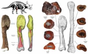
Malignant cancer diagnosed in a dinosaur for the first time
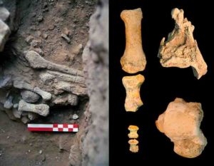
A collaboration led by the Royal Ontario Museum (ROM) and McMaster University has led to the discovery and diagnosis of an aggressive malignant bone cancer — an osteosarcoma — for the first time ever in a dinosaur. No malignant cancers (tumours that can spread throughout the body and have severe health implications) have ever been documented in dinosaurs previously. The paper was published August 3rd in the medical journal The Lancet Oncology.
The cancerous bone in question is the fibula (lower leg bone) from Centrosaurus apertus, a horned dinosaur that lived 76 to 77 million years ago. Originally discovered in Dinosaur Provincial Park in Alberta in 1989, the badly malformed end of the fossil was originally thought to represent a healing fracture. Noting the unusual properties of the bone on a trip to the Royal Tyrrell Museum in 2017, Dr. David Evans, James and Louise Temerty Endowed Chair of Vertebrate Palaeontology from the ROM, and Drs. Mark Crowther, Professor of Pathology and Molecular Medicine, and Snezana Popovic, an osteopathologist, both at McMaster University, decided to investigate it further using modern medical techniques. They assembled a team of multidisciplinary specialists and medical professionals from fields including pathology, radiology, orthopaedic surgery, and palaeopathology. The team re-evaluated the bone and approached the diagnosis similarly to how it would be approached for the diagnosis of an unknown tumour in a human patient.
“Diagnosis of aggressive cancer like this in dinosaurs has been elusive and requires medical expertise and multiple levels of analysis to properly identify,” says Crowther, who is also a Royal Patrons Circle donor and volunteer at the ROM. “Here, we show the unmistakable signature of advanced bone cancer in 76-million-year-old horned dinosaur — the first of its kind. It’s very exciting.”
After carefully examining, documenting, and casting the bone, the team performed high-resolution computed tomography (CT) scans. They then thin-sectioned the fossil bone and examined it under a microscope to assess it at the bone-cellular level. Powerful three-dimensional CT reconstruction tools were used to visualize the progression of the cancer through the bone. Using this rigorous process, the investigators reached a diagnosis of osteosarcoma.
To confirm this diagnosis, they then compared the fossil to a normal fibula from a dinosaur of the same species, as well as to a human fibula with a confirmed case of osteosarcoma. The fossil specimen is from an adult dinosaur with an advanced stage of cancer that may have invaded other body systems. Yet it was found in a massive bonebed, suggesting it died as part of a large herd of Centrosaurus struck down by a flood.
“The shin bone shows aggressive cancer at an advanced stage. The cancer would have had crippling effects on the individual and made it very vulnerable to the formidable tyrannosaur predators of the time,” says Evans, an expert on these horned dinosaurs. “The fact that this plant-eating dinosaur lived in a large, protective herd may have allowed it to survive longer than it normally would have with such a devastating disease.”
Osteosarcoma is a bone cancer that usually occurs in the second or third decade of life. It is an overgrowth of disorganized bone that spreads rapidly both through the bone in which it originates and to other organs, including most commonly, the lung. It is the same type of cancer that afflicted Canadian athlete Terry Fox and led to the partial amputation of his right leg prior to Fox’s heroic Marathon of Hope in 1980.
“It is both fascinating and inspiring to see a similar multidisciplinary effort that we use in diagnosing and treating osteosarcoma in our patients leading to the first diagnosis of osteosarcoma in a dinosaur,” says Seper Ekhtiari, an Orthopaedic Surgery Resident at McMaster University. “This discovery reminds us of the common biological links throughout the animal kingdom and reinforces the theory that osteosarcoma tends to affect bones when and where they are growing most rapidly.”
This study aims to establish a new standard for the diagnosis of unclear diseases in dinosaur fossils and opens the door to more precise and more certain diagnoses. Establishing links between human disease and the diseases of the past will help scientists to gain a better understanding of the evolution and genetics of various diseases. Evidence of many other diseases that we share with dinosaurs and other extinct animals may yet be sitting in museum collections in need of re-examination using modern analytical techniques.
Funding for David Evans was provided by an NSERC Discovery Grant, and research computers for 3D visualization were generously supported by The Dorothy Strelsin Foundation.
Reference:
Seper Ekhtiari, Kentaro Chiba, Snezana Popovic, Rhianne Crowther, Gregory Wohl, Andy Kin On Wong, Darren H Tanke, Danielle M Dufault, Olivia D Geen, Naveen Parasu, Mark A Crowther, David C Evans. First case of osteosarcoma in a dinosaur: a multimodal diagnosis. The Lancet Oncology, 2020; 21 (8): 1021 DOI: 10.1016/S1470-2045(20)30171-6
A new analysis of sandstones from Antarctica indicates there may be important links between the generation of mountain belts and major transitions in Earth’s atmosphere and oceans.
A team of researchers analyzed the chemistry of tiny zircon grains commonly found in the Earth’s continental rock record to determine their ages and chemical compositions. The team included scientists from the University of Wisconsin Oshkosh, Michigan Technological University and ETH Zurich in Switzerland.
The study was published recently in the international peer-reviewed journal Terra Nova, which features short innovative papers about the solid Earth and planetary sciences.
“Mountain building occurs in association with the plate tectonic motions of the continents,” said Paulsen, the lead author on the paper. “Geologists have long recognized that the generation of significant mountainous relief has the potential to profoundly influence the chemistry of the Earth’s oceans and atmosphere.”
Yet there are significant questions about the patterns of mountain building in Earth’s past, especially associated with the ancient rock record leading up to the explosion of life about 541 million years ago.
“Mountains tend to be worn down by water and wind that ultimately transports their sedimentary remains to the oceans, leaving an incomplete puzzle for geologists to fit together,” said Deering, a coauthor on the paper. “However, there is increasing evidence that missing pieces of the puzzle are found in the sands of ancient beaches and rivers, which are essentially the remnants of mountains produced by weathering and erosion.”
The researchers’ findings, based on an analysis of a large sample of zircon grains from sandstone recovered in Antarctica, may signify key links in the evolution of the Earth’s rock cycle and its atmosphere and oceans.
“We found two primary periods of increased average crustal thickness associated with volcanic chains along convergent plate boundaries, implying an increased proportion of higher mountains at these times,” Paulsen said.
“Both episodes occurred during major reorganization of the continents when they separated and drifted on the Earth’s surface over time. They also overlap with snowball Earth glaciations — when the whole Earth was frozen over — and associated steps in oxygenation of the atmosphere, which may have been critical for the evolution of life. These correlations suggest an important causal link between plate tectonics and major transitions in Earth’s atmosphere and oceans.”
Reference:
Timothy Paulsen, Chad Deering, Jakub Sliwinski, Snehamoy Chatterjee, Olivier Bachmann, Marcel Guillong. Crustal thickness, rift‐drift and potential links to key global events. Terra Nova, 2020; DOI: 10.1111/ter.12485
A large number of the valley networks scarring Mars’s surface were carved by water melting beneath glacial ice, not by free-flowing rivers as previously thought, according to new UBC research published today in Nature Geoscience. The findings effectively throw cold water on the dominant “warm and wet ancient Mars” hypothesis, which postulates that rivers, rainfall and oceans once existed on the red planet.
To reach this conclusion, lead author Anna Grau Galofre, former PhD student in the department of earth, ocean and atmospheric sciences, developed and used new techniques to examine thousands of Martian valleys. She and her co-authors also compared the Martian valleys to the subglacial channels in the Canadian Arctic Archipelago and uncovered striking similarities.
“For the last 40 years, since Mars’s valleys were first discovered, the assumption was that rivers once flowed on Mars, eroding and originating all of these valleys,” says Grau Galofre. “But there are hundreds of valleys on Mars, and they look very different from each other. If you look at Earth from a satellite you see a lot of valleys: some of them made by rivers, some made by glaciers, some made by other processes, and each type has a distinctive shape. Mars is similar, in that valleys look very different from each other, suggesting that many processes were at play to carve them.”
The similarity between many Martian valleys and the subglacial channels on Devon Island in the Canadian Arctic motivated the authors to conduct their comparative study. “Devon Island is one of the best analogues we have for Mars here on Earth — it is a cold, dry, polar desert, and the glaciation is largely cold-based,” says co-author Gordon Osinski, professor in Western University’s department of earth sciences and Institute for Earth and Space Exploration.
In total, the researchers analyzed more than 10,000 Martian valleys, using a novel algorithm to infer their underlying erosion processes. “These results are the first evidence for extensive subglacial erosion driven by channelized meltwater drainage beneath an ancient ice sheet on Mars,” says co-author Mark Jellinek, professor in UBC’s department of earth, ocean and atmospheric sciences. “The findings demonstrate that only a fraction of valley networks match patterns typical of surface water erosion, which is in marked contrast to the conventional view. Using the geomorphology of Mars’ surface to rigorously reconstruct the character and evolution of the planet in a statistically meaningful way is, frankly, revolutionary.”
Grau Galofre’s theory also helps explain how the valleys would have formed 3.8 billion years ago on a planet that is further away from the sun than Earth, during a time when the sun was less intense. “Climate modelling predicts that Mars’ ancient climate was much cooler during the time of valley network formation,” says Grau Galofre, currently a SESE Exploration Post-doctoral Fellow at Arizona State University. “We tried to put everything together and bring up a hypothesis that hadn’t really been considered: that channels and valleys networks can form under ice sheets, as part of the drainage system that forms naturally under an ice sheet when there’s water accumulated at the base.”
These environments would also support better survival conditions for possible ancient life on Mars. A sheet of ice would lend more protection and stability of underlying water, as well as providing shelter from solar radiation in the absence of a magnetic field — something Mars once had, but which disappeared billions of years ago.
While Grau Galofre’s research was focused on Mars, the analytical tools she developed for this work can be applied to uncover more about the early history of our own planet. Jellinek says he intends to use these new algorithms to analyze and explore erosion features left over from very early Earth history.
“Currently we can reconstruct rigorously the history of global glaciation on Earth going back about a million to five million years,” says Jellinek. “Anna’s work will enable us to explore the advance and retreat of ice sheets back to at least 35 million years ago — to the beginnings of Antarctica, or earlier — back in time well before the age of our oldest ice cores. These are very elegant analytical tools.”
Reference:
Grau Galofre, A., Jellinek, A.M. & Osinski, G.R. Valley formation on early Mars by subglacial and fluvial erosion. Nat. Geosci., 2020 DOI: 10.1038/s41561-020-0618-x
One of the big questions in biology is why certain plants and animals are found in some places and not others. Figuring out how species evolve and spread, and why some places are richer in species than others, is key to understanding and protecting the world around us. Mountains make a good laboratory for scientists tackling these questions: mountains are home to tons of biodiversity, in part due to all the different habitats at different elevations. In a new study in Science, researchers examined the plant life in the China’s Hengduan Mountains, the Himalaya Mountains, and the Qinghai-Tibet Plateau. Using DNA to build family trees of species, they learned that the diversity of plants in that region today can be traced back to newly-formed mountain ranges 30 million years ago, and monsoons that came later. It’s a concrete example of how climatic and environmental changes influence life on Earth.
“This paper addresses the fundamental question of why there are so many species in some parts of the world and not others,” says Rick Ree, a curator at Chicago’s Field Museum and corresponding author of the Science study. “The formation of this very species-rich community was fueled by ancient mountain-building and then subsequent effects of the monsoon. The biodiversity that we see today has been profoundly shaped by geology and climate.”
The paper focuses on plants growing above the treeline (called the alpine zone) in the Hengduan Mountains of southwestern China. “It’s an incredibly interesting part of the world, it’s a relatively small area that harbors one-third of all the plant species in China,” says Ree. “In the Hengduan Mountains, you can see coniferous forests, rushing glacial streams, craggy valleys, and meadows just teeming with wildflowers.” Some of the flowers, Ree notes, might be familiar to Western gardeners, including rhododendrons and delphiniums.
Ree and his colleagues wanted to find out how plants are distributed in the alpine regions of the Hengduan Mountains, Himalaya, and Qinghai-Tibet Plateau, and how they got there in the first place. To figure it out, they turned to phylogenetic reconstructions: essentially, using DNA and key pieces of fossil evidence to piece together the plants’ family trees, going back tens of millions of years.
The researchers compared the DNA of different plant species that live in the region, determining how closely related they were to each other and how they evolved. If you have DNA sequences for a bunch of different plants, by looking at the differences in their DNA and using fossil plants as benchmarks for how long it takes new species to arise, you can make an educated guess as to how long ago their common ancestor lived and figure out the family tree that makes the most sense.
In this study, Ree and his colleagues were able to trace the origins of alpine plants in the Hengduan, Himalaya, and Qinghai-Tibet Plateau. Many of the plants first evolved in the Hengduan Mountains. Then, as the Indian tectonic plate collided with Asia, slowly creating new mountains, a bunch of new habitats formed up the mountains’ sides and in the valleys below. And as the new mountains formed, the region began to experience more intense monsoons, possibly because the mountains altered the prevailing winds, creating new weather conditions.
“The combined effect of mountain-building and monsoons was like pouring jet fuel onto this flame of species origination,” says Ree. “The monsoon wasn’t simply giving more water for plants to grow, it had this huge role in creating a more rugged topography. It caused erosion, resulting in deeper valleys and more incised mountain ranges.”
“The theory is, if you increase the ruggedness of a landscape, you’re more likely to have populations restricted in their movement because it’s harder to cross a deeper valley than a shallow valley. So any time you start increasing the patchiness and barriers between populations, you expect evolution to accelerate,” says Ree.
And that’s exactly what the team found in reconstructing the plants’ genetic family tree: as the landscape grew more rugged over time, the now-isolated populations of plants veered off into their own separate species, resulting in the biodiversity we see today.
In addition to showing how geological and climate changes over the last 30 million years affect today’s spread of plants, Ree notes that the study has implications for better understanding the climate change the Earth is currently experiencing.
“This study sheds light on the conditions under which we get rich versus poor biodiversity,” says Ree. “Mountain ecosystems tend to be very sensitive to things like global warming, because the organisms that live there are dependent on a tight range of elevation and temperature. Understanding how historical environmental change affected alpine plants twenty million years ago can help us predict how today’s climate change will affect their descendants.”
Reference:
Wen-Na Ding, Richard H. Ree, Robert A. Spicer, Yao-Wu Xing. Ancient orogenic and monsoon-driven assembly of the world’s richest temperate alpine flora. Science, 2020; 369 (6503): 578 DOI: 10.1126/science.abb4484
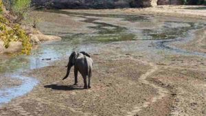
An African Elephant walks through the drying streambed of Chitake Springs as the drought season descends on Mana Pools National Park in Zimbabwe Photo credit: Trisha Atwood.
One million years ago, the extinction of large-bodied plant-eaters changed the trajectory of life on Earth. The disappearance of these large herbivores reshaped plant life, altered fire regimes across Earth’s landscapes, and modified biogeochemical cycling in such a way that Earth’s climate became slightly colder. A new study out today by Utah State University Assistant Professor of Watershed Sciences, Trisha Atwood, suggests that modern-day megaherbivores (plant-eaters weighing more than 1000 kg) could soon suffer the same fate as their ancient ancestors, with unknown consequences for Earth and all of its inhabitants.
Armed with a dataset of the diets of over 24,500 mammals, birds, and reptiles, Atwood and her team set out to answer the question “Are plant-eaters, meat-eaters, or animals who eat both plants and meat, at the greatest risk of extinction?” Their findings, published in the journal Science Advances, would challenge a two-decade-long perception that meat-eating predators were the most likely group to meet the ire of Earth’s six mass extinction.
The results indicate that with over a quarter of the world’s modern-day herbivores threatened with extinction, plant eaters have the highest representation of at-risk species in the present day. The study also highlights that this attack on herbivores is not a new phenomenon. Human activities have led to the disproportionate extinction of herbivores compared to predators since at least the late Pleistocene (11,000-50,000 years ago).
“The results were somewhat shocking,” said Atwood. “Our highly publicized and fraught relationship with predatory animals such as lions and wolves has led to the unfounded perception that we are losing predators more than any other trophic group.”
Using evidence-based science to challenge misconceptions like the one Atwood’s team uncovered is essential for getting society on the right track towards addressing future extinctions. Because a species’ role in its ecosystem is intricately linked to what it eats, understanding whether predators, herbivores, or omnivores are at the highest risk of extinction helps scientists and society understand what the potential consequences of losing those species are.
Already the consequences of declines in modern herbivores from land-use change and hunting have begun to echo those that occurred on Earth 1 million years ago; alterations to plant life, changes to fire regimes, and disruptions to nutrient cycling. This study highlights that we must redouble our efforts to strategically invest in conservation and management of herbivores to avoid future dramatic changes in the functions arising from animals at the base of global foodwebs.
Although the results of the study indicate that herbivores are the most at-risk group, it is not clear sailing for predators. The study also identified scavengers, which eat the remains of recently deceased animals (e.g., vultures) and animals that primarily eat fish, such as seabirds, as having a heightened risk of extinction.
“Our results enable us to identify specialized diets within the carnivores that are associated with higher extinction risk, and also identify the habitats these species live in,” says Edd Hammill an Assistant Professor of Watershed Sciences at Utah State University and co-author of the study. “It would appear that seabirds across the globe suffer disproportionately high levels of extinction”
To better inform conservation actions, the researchers are now wrestling to understand what it is about herbivores, scavengers, and piscivores (animals that consume fish) that make them more susceptible to extinction compared to other animals.
“Documenting a pattern in extinctions is only the first step towards curbing the loss of species,” says Atwood. “Our next step is to understand the intricacies of why this pattern is occurring; only then will we really have a chance at stopping these future extinctions.”
Reference:
Trisha B. Atwood, Shaley A. Valentine, Edd Hammill, Douglas J. McCauley, Elizabeth M. P. Madin, Karen H. Beard, William D. Pearse. Herbivores at the highest risk of extinction among mammals, birds, and reptiles. Science Advances, 2020; 6 (32): eabb8458 DOI: 10.1126/sciadv.abb8458
The first dinosaurs laid soft-shelled eggs that resembled those of a turtle, a new study led by the Museum and Yale University has found, contradicting the long-held thought that all dinosaur eggs were hard-shelled. It also suggests that calcified eggs evolved independently at least three times in the dinosaur family tree.
“Over the last 20 years, we’ve found dinosaur eggs around the world. But for the most part, they only represent three groups—theropod dinosaurs, which includes modern birds, advanced hadrosaurs like the duck-bill dinosaurs, and advanced sauropods, the long-necked dinosaurs,” said Mark Norell, chair and Macaulay Curator in the Museum’s Division of Paleontology and lead author of the study, which is published today in the journal Nature. “At the same time, we’ve found thousands of skeletal remains of ceratopsian dinosaurs, but almost none of their eggs. So why weren’t their eggs preserved? My guess—and what we ended up proving through this study—is that they were soft-shelled.”
Amniotes—the group that includes birds, mammals, and reptiles—produce eggs with an inner membrane or “amnion” that helps to prevent the embryo from drying out. Some amniotes, such as many turtles, lizards, and snakes, lay soft-shelled eggs. Others, such as birds, lay eggs with hard, heavily calcified shells. Because modern crocodilians and birds, which are living dinosaurs, lay hard-shelled eggs, it was long assumed that all non-avian dinosaurs laid hard eggs.
The researchers studied embryo-containing fossil eggs belonging to two species of dinosaur: Protoceratops, a sheep-sized plant-eating dinosaur that lived in what is now Mongolia between about 75 and 71 million years ago, and Mussaurus, a long-necked, plant-eating dinosaur that grew to 20 feet in length and lived between 227 and 208.5 million years ago in what is now Argentina.
In the well-preserved Protoceratops specimen, researchers noticed a black-and-white egg-shaped halo associated with skeletal embryos in the fossilized clutch. When the scientists took a closer look with a suite of sophisticated geochemical methods, they found evidence of the proteinaceous membrane that makes up the innermost eggshell layer of all modern archosaur eggs, those of birds and crocodilians. The same was true for the Mussaurus specimen.
When researchers compared the biomineralization signature of the dinosaur eggs with eggshell data from other animals, they determined that the Protoceratops and Mussaurus eggs were not biomineralized but rather leathery and soft.
“It’s an exceptional claim, so we need exceptional data,” said study author and Yale graduate student Jasmina Wiemann. “We had to come up with a brand-new proxy to be sure that what we were seeing was how the eggs were in life, and not just a result of some strange fossilization effect.”
With data on the chemical composition and mechanical properties of eggshells from 112 other extinct and living relatives, the researchers constructed a “super tree” to track the evolution of the eggshell structure and properties through time. They found that hard-shelled, calcified eggs evolved independently at least three times in dinosaurs.
Soft eggshells are sensitive to water loss and would not hold up well under the weight of a brooding parent. Because of this, the researchers propose that the eggs were likely buried in moist soil or sand and incubated with heat from decomposing plant matter, much like what some reptiles do with their eggs today.
The depth of a hydraulic fracturing well in Oklahoma, among other factors, increases the probability that fracking will lead to earthquake activity, according to a new report in the Bulletin of the Seismological Society of America.
The researchers hope their findings, published as part of an upcoming BSSA special issue on observations, mechanisms and hazards of induced seismicity, will help oil and gas operators and regulators in the state refine drilling strategies to avoid damaging earthquakes.
During hydraulic fracturing, well operators inject a pressurized liquid into a rock layer after drilling vertically and often horizontally through the rock. The liquid breaks apart — fractures — the rock layer and allows natural gas or petroleum to flow more freely. A growing number of studies suggest that this process can induce seismic activity large enough for people to feel, possibly by increasing fluid pressures within the rock that relieve stress on faults and allow them to slip.
In one rock layer examined in the BSSA study, the likelihood that hydraulic fracturing triggered seismic activity increased from 5 to 50 percent as well operations moved from 1.5 to 5.5 kilometers (0.9 to 3.4 miles) deep, the researchers found.
Although the exact mechanisms linking well depth and seismic probability are still being examined, Michael Brudzinski and colleagues suggest that the overpressure of fluids trapped inside the rock may be important.
“The deeper the rock layers are, the more rock that is sitting on top of a well, and that is going to potentially increase the fluid pressures at depth,” said Brudzinski, the study’s corresponding author from Miami University in Ohio.
Oklahoma has been at the center of a dramatic increase in earthquake activity over the past decade, mostly caused by oil and gas companies injecting wastewater produced by drilling back into deeper rock layers. However, a 2018 study identified places in the state where significant amounts of seismic activity were linked to nearly 300 hydraulic fracture wells.
Hydraulic fracturing is associated with a magnitude 4.6 earthquake in Canada and a magnitude 5.7 earthquake in China, although fracking-induced earthquakes tend to be smaller in magnitude than those caused by wastewater disposal. As a result, oil and gas operators and regulators would like to know more about why some wells trigger seismic activity, and how to adjust their operations to prevent damaging earthquakes.
Brudzinski and colleagues found the link between depth and seismic probability in their examination of data from 929 horizontal and 463 vertical hydraulic fracturing wells in Oklahoma. The scientists used publicly available data on injected volume at well sites, the number of wells on a drilling pad, what kind of fluid was injected, and the vertical depth of the well, among other features.
The total volume of injected liquid at the Oklahoma wells did not affect the probability of seismic activity near the wells — a surprising finding that differs from other studies of induced seismicity. Some previous hydraulic fracturing (and wastewater disposal) studies show an increase in seismic activity with increasing volume.
Most of the wells in the current study are single wells, however, and not multiple wells clustered on a drilling pad, Brudzinski noted. In some places in western Canada and Texas, where there is a link between the injected volume and seismicity, multiple wells on a pad are more common.
“So that’s where we started to think that perhaps that’s the difference between what we’re seeing in our study versus other studies,” Brudzinski said. “We’re proposing that multiple wells injecting next to each other may be why volume does matter in those cases, although we need to study it more.”
“It could be that volume does still matter, but more so in a cumulative way than for any given well,” he added. “An isolated well with a large volume may not have nearly as much of a [seismic] risk as a large volume well that is in close proximity to other large volume wells.”
The researchers also compared the probability of seismic activity in wells where the injected liquid was a gel versus “slickwater” — water with chemicals added to increase flow. They found a lower level of seismicity in gel operations compared to slickwater, although the difference wasn’t as statistically significant as the other trends.
Simulation studies suggest that the more viscous gel may not flow as far as the slickwater, limiting its effects on faults, Brudzinski said.
Reference:
Rosamiel Ries, Michael R. Brudzinski, Robert J. Skoumal, Brian S. Currie. Factors Influencing the Probability of Hydraulic Fracturing-Induced Seismicity in Oklahoma. Bulletin of the Seismological Society of America, 2020; DOI: 10.1785/0120200105
Amud 9 fossils. Credit: Osborjn M. Pearson and Adrián Pablos
Adrián Pablos, a scientist at the Centro Nacional de Investigación sobre la Evolución Humana (CENIEH), led a study published in PaleoAnthropology, the official journal of the PaleoAnthropology Society, looking at the morphology and anatomy of a partial foot recovered over 25 years ago at Amud Cave, which confirms that the individual Amud 9 was a Neandertal woman from the Late Pleistocene, with a stature of some 160-166 cm and weight of 60 kg.
Over the course of several excavations conducted in the 20th century at Amud Cave, remains of at least 15 Neandertals were found. A systematic and detailed study of one of these individuals, Amud 9, has found that the fossil possesses the traits usually associated with Neanderthals in the characteristics of the foot, tarsals, metatarsals and phalanges, which differ from those of modern humans, both fossil and recent.
“Most of these traits are related to the typical, exceptional robustness of the postcranial skeleton, that is, from the neck down, observed in the majority of Neandertals,” explains Pablos.
Sex, weight and height
Sex, weight, and height estimates in fossil populations are normally based on the dimensions of the large leg bones. However, in the case of Amud 9, only a fragment of tibia, the talus or ankle bone, one metatarsal or instep bone, and several phalanges are conserved.
As no long leg bones have been found, the researchers applied different mathematical estimates based upon the foot bones, thus obtaining an approximation to important paleobiological parameters.
“Knowing parameters such as the body size and sex of this individual helps us learn a bit more about what the Neandertals were like,” he says.
Reference:
Pearson, O.M., Pablos, et al. A partial Neandertal foot from the Late Middle Paleolithic of Amud cave. PaleoAnthropology 2020, 98-125. DOI: 10.4207/PA.2020.ART144
Note: The above post is reprinted from materials provided by CENIEH .
Broad surfaces called terraces preserve ancient river floodplains and landscape history up to hundreds of meters above the Fortymile River, a tributary of the Yukon River, in eastern Alaska. Researchers from the USGS, the University of Vermont, Purdue University and Utah State University publish definitive support that increases in sediment deposited to oceans from river erosion coincide with dramatic changes in glacial cycles. Credit: USGS
Scientists have long debated the idea that global climate changes have forced river erosion rates to increase over the past five million years. New field data gleaned from a multi-institution, collaborative study of North America’s rugged Yukon River basin, near storied Klondike goldfields, reveal profound increases in river erosion during abrupt global intensification of climate fluctuations about 2.6 and one million years ago.
“These results provide the first definitive support that increases in sediment deposited to oceans from river erosion coincide with dramatic changes in glacial cycles,” says Utah State University geoscientist Tammy Rittenour. “Our ability to date former river deposits was the game-changing factor in allowing us to pursue this hypothesis.”
Rittenour and colleagues from the U.S. Geological Survey, the University of Vermont and Purdue University published findings in the July 20, 2020, issue of Nature Geoscience.
“Oxygen isotope values in marine sediment show worldwide fluctuations between cold and warm climates that abruptly intensified during the early Pleistocene period,” says Rittenour, professor in USU’s Department of Geosciences. “Rates of river sediment accumulation also jumped during this time.”
Since rivers do the work of erosion and sediment transport over most of the Earth’s surface, scientists have long suggested patterns of global precipitation mimic climate fluctuations.
“If that’s the case, enhanced river discharge resulting from intensified global precipitation would increase rates of river erosion,” she says.
To test this idea, the team took advantage of the landscape history preserved in the study site’s prominent river terraces — ancient river floodplains — perched up to hundreds of meters above the modern Fortymile River, a Yukon River tributary that flows from northwestern Canada to Alaska.
“This ‘Rosetta-stone’ location, with exposed terraces, provided a long-sought window from which to obtain data,” says Rittenour, a Geological Society of America Fellow. “We geochronologists often repeat the adage, ‘No Dates, No Rates,’ meaning we can’t calculate rates of erosion without age control. Using relatively new dating techniques, we were able, for the first time, to establish ages for river deposits that span these key time periods of global climate change.”
Co-authors Lee Corbett and Paul Bierman of UVM and Marc Caffee of Purdue provided age control on the site’s older terraces, using cosmogenic nuclide burial dating methods that use differing decay rates of unique radiogenic isotopes of beryllium and aluminum produced by sediment exposure to cosmic radiation.
Rittenour, director of USU’s Luminescence Laboratory, used optically stimulated luminescence dating of younger river sediments.
“OSL dating provides an age estimate of the last time the sediment was exposed to light,” she says.
Corroborating the team’s new results, Bering Sea sediment records show concurrent increases in accumulation of sediment eroded from the Fortymile River.
“It’s exciting to apply new tools to test foundational ideas that have been only previously speculated,” Rittenour says. “These results represent an important step toward understanding the influence of climate in shaping landscapes inhabited by people, and provide clues regarding future landscape response to human activity.”
Reference:
Adrian M. Bender, Richard O. Lease, Lee B. Corbett, Paul R. Bierman, Marc W. Caffee, Tammy M. Rittenour. Late Cenozoic climate change paces landscape adjustments to Yukon River capture. Nature Geoscience, 2020; DOI: 10.1038/s41561-020-0611-4
Note: The above post is reprinted from materials provided by Utah State University. Original written by Mary-Ann Muffoletto.