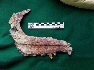
The fossilized jaw of an Overoraptor chimentoi, a new species of dinosaur discovered in Argentine Patagonia
Fossilized remains of a new species of dinosaur that lived 90 million years ago have been discovered in Patagonia, Argentine paleontologists announced on Thursday.
The winged dinosaur had legs similar to the velociraptor and experts believe it may hold the key to revealing information about the evolution of birds.
The fossil remains, which measure less than a meter and a half in length, were discovered at a dig in the province of Rio Negro in Argentine Patagonia, around 1,100 kilometers (685 miles) from Buenos Aires, the scientific dissemination agency from the La Matanza university said.
It is a new species of carnivorous Paraves theropod that has been named Overoraptor chimentoi, explained Matias Motta, a researcher from the Argentine natural sciences museum.
It is related to another species found more than 10,000 kilometers away in Madagascar.
The first remains were discovered in 2013, with more fossils found in a second dig in 2018.
“This animal had a very sharp claw on its index toe, which certainly was used to attack prey, and it had a long and graceful leg, which indicates it was a running animal,” said Motta, the main author of the study published in The Science of Nature magazine.
“It was certainly fast, agile and, like all its relatives, it would have been carnivorous.”
Researchers were surprised to find that while its legs were similar to the “raptor” family of dinosaurs, its upper limbs were very long and robust, similar to modern birds.
The second dig uncovered many bones, including an almost complete foot, tail vertebrae and parts of a wing, said paleontologist Federico Brisson Egli.
Previous discoveries in Patagonia of dinosaurs with bird-like features belonged to the Unenlagia genus of dromaeosaurid theropods, which were agile and walked on their hind legs.
“Contrary to what we originally assumed, the Overoraptor is not part of the Unenlagia family, but from another group including a Madagascan species called Rahonavis,” said paleontologist Fernando Novas.
Note: The above post is reprinted from materials provided by AFP.
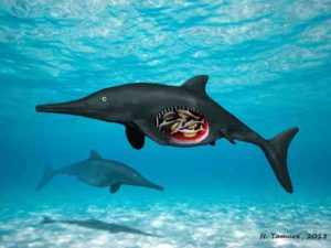
Image of pregnant ichthyosaur with octuplets. Credit: Copyright Nobumichi Tamura
Autumn was closing in fast on northern Nevada when Martin Sander took one last look around the excavation site in the Augusta Mountains 150 miles (241 kilometers) east of Reno.
The longtime paleontologist from Germany had been working summers in Nevada for 20 years by that point and believed in the maxim that, “we find the spectacular things on the second to last day or last day.”
It was Oct. 3, 2011, and Sander and his team were nearing the end of a two-week expedition in an area that’s a hotspot for ichthyosaur fossils.
Just getting to the site requires hours of driving on dirt from Winnemucca or Lovelock and hours more hiking from base camp.
When the team packs up and leaves for the season they know it might be months, or even years, before they return.
Sander’s decision to take another trip around the site proved fateful.
“The trick is you have to know what you are looking for,” said Sander, who described that final stroll as “wandering around in the field.”
At an outcropping around 6,000 feet (1,829 meters) in elevation he spotted what appeared to be fossilized remains of an ichthyosaur spine. Further, there was evidence the large, prehistoric, swimming reptile had been pregnant when it died.
“I found it and realized pretty quickly what I was looking at,” Sander said.
The next day, with cold and snow closing in, the team packed up the exposed fossils for further research. They returned in 2014 and excavated the rest.
Last month, they published a paper on the findings.
The ichthyosaur was the second-oldest pregnant specimen ever found and it was of a species that had never before been identified.
Even more remarkable, it was just one of two major ichthyosaur findings at the location in the Augusta Mountains.
“It is an incredible place and there is new stuff coming out all the time,” Sander said. “Everything we touch, new stuff is coming out of it.”
The other finding hasn’t yet been published in an academic journal, but it involves an ichthyosaur fossil Sander refers to as “the giant skull.”
While the paper detailing the specifics of the giant skull fossil aren’t yet published, Sander says the findings are, well, big.
“It is the first big thing that lived on this earth,” he said of the beast, which had a skull so big researchers had to borrow a beer truck to haul it away.
Although “the giant skull” may prove the more significant of the two recent discoveries, Sander says there’s plenty to celebrate about the pregnant ichthyosaur dubbed “Martina,” by the scientists.
For starters, at 246 million-years-old Martina is the second-oldest specimen of a pregnant ichthyosaur. The oldest is a 249-million-year-old specimen from China.
Martina is also a species of ichthyosaur, Cymbospondylus duelferi, that hasn’t been found anywhere else, according to Sander’s research.
Researchers know because literature reviews that were part of the scientific reporting showed Martina had characteristics not found in any other ichthyosaur fossils.
At about 12 feet (3.6 meters) long she was smaller than other ichthyosaurs, some of which are as large as 60 feet (18 meters) . Despite her smaller body, Martina’s teeth were larger than expected for an ichthyosaur of similar size.
The teeth, about an inch in length, would have helped her tear up prey such as squid or fish that were in the sea that covered what is now Nevada.
“She was a pretty fierce lady,” Sander said, comparing her to a much larger sample found in another Nevada range. “She is half the size but her teeth are nearly as big as the bigger one from the Humboldt Range.”
Martina and “the giant skull” also add to the diversity of Nevada’s ichthyosaur legacy. The specimens, both from the early triassic period, show how quickly life evolved following the Permian-Triassic extinction event.
The extinction event, which is thought to have wiped out as many as 96% of species, happened 252 million years ago.
That ichthyosaurs of immense size and diversity are found dating back to a few million years later suggests the animals evolved relatively quickly.
“The cool thing about it is … they just diversified crazily fast,” Sander said. “In Nevada you see this incredible explosion of ichthyosaurs.”
One of the reptiles’ adaptations, as Martina demonstrates, is they would have evolved from laying eggs to giving live birth, which would have been an advantage in their move to the sea, Sander said.
He compared it to the advantage a whale or dolphin has over a sea turtle, the latter of which is exposed, along with offspring, to danger by having to leave the water to lay eggs on shore.
“Most of the reptiles that returned to the sea, they all evolved this ability from egg laying to giving birth to live young,” he said.
While both Martina and the giant skull are exciting to researchers like Sander, they’ve also captured the imagination of people like craft brewer Tom Young, who has emerged as a major paleontology booster in Nevada.
Young, a former geologist, is the founder of Great Basin Brewing in Reno, which produces Ichthyosaur, or Icky, IPA. It was his beer truck researchers used to haul the giant skull from the Augusta Mountains to the Los Angeles Museum of Natural History.
And it’s Young whose made it his mission to popularize paleontology in Nevada.
“It is so important we preserve this and study these things to show where we are today and how we got here,” Young said. “You marvel as a human and realize the importance of our being here now, but at the same time you are looking at us as part of this much larger, huge universe.”
Young’s enthusiasm carries over to financial support. He’s contributed thousands of dollars, and plenty of beer, to research efforts. He’s also hosted brewery fundraisers that attract hundreds of people who want to hear directly from the scientists.
“I’m ecstatic when people give a crap about science,” Young said.
All three said they’d like to see the state develop a repository with the tools and talent to meet requirements for keeping ichthyosaur fossils recovered from public land.
Nevada’s Berlin-Ichthyosaur State Park retains fossils that are on display as they were found. But many significant finds are trucked to Berkeley or Los Angeles where there are repositories that meet federal standards.
“It should give Nevada some great pride we have some the coolest and biggest and meanest things to evolve on Earth here in our backyard,” Young said.
In recent years some of the most significant ichthyosaur findings have been outside Nevada, including an amphibious ichthyosaur from China that filled an evolutionary gap and a fossil in the United Kingdom from an ichthyosaur thought to be among the largest animals to ever live on the planet.
The paper on Martina and upcoming revelations about the giant skull will likely bring Nevada back into the spotlight.
Paula Noble, a professor of paleontology at University of Nevada, Reno, said that’s good news if it inspires more interest in science, especially among young people.
“Paleo is a great hook,” said Noble. “It is not just this stodgy thing we do in a lab.”
Note: The above post is reprinted from materials provided by The Associated Press.
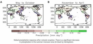
El Niño events and high-latitude Eurasian warming are usually observed after large tropical eruptions. However, simulations of climate impacts by volcanos show large biases when compared with observations, calling for substantial improvements in climate models. The graph depicts the change in zonally averaged surface temperature in observations (the shaded part) and simulations (the line) after large tropical volcanic eruptions. The equation denotes the chemical reaction in the stratosphere. Credit: Advances in Atmospheric Sciences
Climatologists have found that if an ongoing Philippine volcanic eruption becomes more violent, the gases released are likely to produce an El Niño event during the 2020-21 winter, a more intense polar vortex and warming across Eurasia.
When Taal volcano near Manila started erupting on January 12, ash spewed 14 kilometers into the air, coating villages in a blanket of dust and affecting nearly 460,000 people, many of whom lost access to electricity and fresh water. Despite the significant impact, the eruption so far has been tame compared to some of the biggest eruptions in history, and the Philippine Institute of Volcanology and Seismology (PHIVOLCS) has since downgraded its alert.
But these same volcanologists now warn that the Taal volcano may merely be in a lull and that the risk of a more dangerous eruption still exists.
“The Taal eruption has been terrible for local communities,” said Fei Liu, a researcher with China’s Sun Yat-sen University, “but it has also become a deep global concern, with potentially hazardous consequences for the Earth’s climate.”
Fine ash and sulfur dioxide from eruptions block incoming solar radiation, thus reducing heat at Earth’s surface that in turn produces atmospheric warming. As a result, for a year after especially violent eruptions, temperatures can be cooler than normal across much of the planet. But in addition to the cooling, there can also be a warming in the first post-eruption winter in the northern hemisphere as surface temperatures rebounds.
However, there are still some gaps between the climate impacts of volcanoes projected by computer simulations and what observations demonstrate. So Liu’s team are using the Taal eruption as a real-time assessment tool of the impact of volcanic eruptions on the climate in order to improve models.
The team’s research, joined by scientists from Nanjing University of Information Science and Technology, University of Hawaii, Zhejiang University, Institute of Atmospheric Physics at Chinese Academy of Sciences, Nanjing Normal University, and University of Gothenburg, is reported as a “News &Views” article in Advances in Atmospheric Sciences.
The researchers took data on the scale of volcanic eruptions worldwide over the past 1,100 years taken from Greenland and Antarctica ice cores and inputted this into global climate models. This then allowed them to project the impact of the Taal eruption.
They reckon there is a high likelihood (83% probability) of an El Niño-like warming event during the 2020/21 winter if the magnitude of the Taal eruption reaches a mid-range “volcanic explosive index”. Such an eruption would also produce an enhanced polar vortex— a large area of low pressure and cold air surrounding the Earth’s North and South poles, which in turn would drive warming across the Eurasian continent.
The researchers’ next step will be to use the eruption to better assess impacts from stratospheric aerosol geo-engineering (also known as solar radiation management), a theoretical method of reducing global warming by injecting sulfate aerosols into the stratosphere via balloons that would work as a sort of ‘deliberate’ volcanic eruption.
Reference:
Fei Liu et al, Could the Recent Taal Volcano Eruption Trigger an El Niño and Lead to Eurasian Warming?, Advances in Atmospheric Sciences (2020). DOI: 10.1007/s00376-020-2041-z
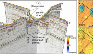
The deep origin of craters and mounds was discovered using cutting edge 3D seismic technology which can penetrate deep into the ocean floor, and help scientists visualize the structures in the hard bedrock underneath. Illustration: M. Waage
A paper published in Science in 2017 described hundreds of massive, kilometer -wide, craters on the ocean floor in the Barents Sea. Today more than 600 gas flares are identified in and around these craters, releasing the greenhouse gas steadily into the water column. Another study, published the same year in PNAS, mapped several methane mounds, some 500m wide, in the Barents Sea. The mounds were considered to be signs of soon-to-happen methane expulsions that have created the said craters.
The most recent study in Scientific Reports looks into the depths far beneath these craters in the ocean floor and reveals the geological structures that have made the area prone to crater formation and subsequent methane expulsions.
“It turns out that this area has a very old fault system — essentially cracks in bedrock that likely formed 250 million years ago. Craters and mounds appear along different fault structures in this system. These structures control the size, placement, and shape of the craters. The methane that is leaking through the seafloor originates from these deep structures and is coming up through these cracks.” according to Malin Waage, a postdoc at CAGE, Centre for Arctic Gas Hydrate, Environment and Climate, and the first author of the study.
Cutting edge 3D seismic technology
The deep origin of craters and mounds was discovered using cutting edge 3D seismic technology which can penetrate deep into the ocean floor, and help scientists visualize the structures in the hard bedrock underneath.
“Our previous studies in the area hypothesized that climate warming and the retreat of the ice sheet some 20,000 years ago, caused the gas hydrates beneath the ice to melt leading to abrupt methane release and creating craters.”
Gas hydrates are a solid form of methane, among others, that is stable in cold temperatures and under pressure, which an enormous ice sheet provides. As the ocean warmed up, and the pressure of the ice sheet lifted, the methane ice in the seafloor melted and thus the craters were formed.
“This study, however, ads several layers to that picture, as we now see that there has been a structural weakness beneath these giant craters, for much longer than the last 20,000 years. Deep below the seafloor, the expansion of gas and release of water build up a muddy slurry which eventually erupted through the fractures and caused seafloor collapses and craters in the hard bedrock. Think of it as a building: A roof of a building can cave in if the ground structure is weak. We believe that this is what happened in the crater area after the last glaciation.” says Waage.
The Barents Sea is poorly understood
The exploration of petroleum resources in the Barents Sea is a hot topic in Norway and beyond as the area is a part of a vulnerable Arctic ecosystem. But the area’s geological system is poorly understood.
“Our 3D survey covered approximately 20 percent of the entire crater area. We believe that it is important to understand if similar fault systems exist in the larger context of the Barents Sea because they potentially could pose a threat to marine operations.”
Some of the questions that scientists, society and the industry does not know the answer to are: Will these weak structures lead to unpredictable and explosive methane release? Can such release and related geohazards be triggered by drilling? And can the gas reach the atmosphere in case of abrupt blow-outs, adding to the greenhouse gas budget?
“There is still very much that we don’t know about this system. But we are currently collecting and analyzing new data in the Barents Sea, dominated by similar crater structures. This can help us map in bigger detail the fault systems and associated weakness. ” says Waage.
Reference:
Malin Waage, Pavel Serov, Karin Andreassen, Kate A. Waghorn, Stefan Bünz. Geological controls of giant crater development on the Arctic seafloor. Scientific Reports, 2020; 10 (1) DOI: 10.1038/s41598-020-65018-9
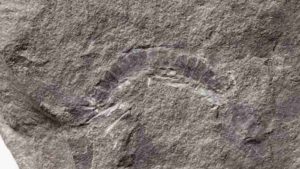
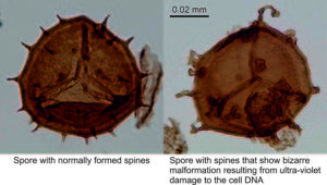
UT Austin scientists found that the fossil millipede Kampecaris obanensis was 425 million years old. Credit: British Geological Survey
A 425-million-year-old millipede fossil from the Scottish island of Kerrera is the world’s oldest “bug”—older than any known fossil of an insect, arachnid or other related creepy-crawly, according to researchers at The University of Texas at Austin.
The findings offer new evidence about the origin and evolution of bugs and plants, suggesting that they evolved much more rapidly than some scientists believe, going from lake-hugging communities to complex forest ecosystems in just 40 million years.
“It’s a big jump from these tiny guys to very complex forest communities, and in the scheme of things, it didn’t take that long,” said Michael Brookfield, a research associate at UT Austin’s Jackson School of Geosciences and adjunct professor at the University of Massachusetts Boston. “It seems to be a rapid radiation of evolution from these mountain valleys, down to the lowlands, and then worldwide after that.”
The research was recently published in the journal Historical Biology. Brookfield led the study with co-authors including Elizabeth Catlos, a professor in the Jackson School’s Department of Geological Sciences, and Stephanie Suarez, a doctoral student at the University of Houston who made improvements to the fossil dating technique used in the study when she was an undergraduate at the Jackson School.
The team found that the ancient millipede fossil is 425 million years old, or about 75 million years younger than the age other scientists have estimated the oldest millipede to be using a technique known as molecular clock dating, which is based on DNA’s mutation rate. Other research using fossil dating found that the oldest fossil of a land-dwelling, stemmed plant (also from Scotland) is 425 million years old and 75 million years younger than molecular clock estimates.
Although it’s certainly possible there are older fossils of both bugs and plants, Brookfield said that the fact they haven’t been found—even in deposits known for preserving delicate fossils from this era—could indicate that the ancient millipede and plant fossils that have already been discovered are the oldest specimens.
If that’s the case, it also means both bugs and plants evolved much more rapidly than the timeline indicated by the molecular clock. Bountiful bug deposits have been dated to just 20 million years later than the fossils. And by 40 million years later, there’s evidence of thriving forest communities filled with spiders, insects and tall trees.
“Who is right, us or them?” Catlos said. “We’re setting up testable hypotheses—and this is where we are at in the research right now.”
Given their potential evolutionary significance, Brookfield said that he was surprised that this study was the first to address the age of the ancient millipedes.
Suarez said a reason could be the difficulty of extracting zircons—a microscopic mineral needed to precisely date the fossils—from the ashy rock sediment in which the fossil was preserved. As an undergraduate researcher at the Jackson School, Suarez developed a technique for separating the zircon grain from this type of sediment. It’s a process that takes practice to master. The zircons are easily flushed away when trying to loosen their grip on the sediment. And once they are successfully released from the surrounding rock, retrieving the zircons involves an eagle-eyed hunt with a pin glued to the tip of a pencil.
“That kind of work trained me for the work that I do here in Houston,” Suarez said. “It’s delicate work.”
As an undergraduate, Suarez used the technique to find that a different millipede specimen, thought to be the oldest bug specimen at the time, was about 14 million years younger than estimated—a discovery that stripped it of the title of oldest bug. Using the same technique, this study passes the distinction along to a new specimen.
Reference:
M. E. Brookfield et al. Myriapod divergence times differ between molecular clock and fossil evidence: U/Pb zircon ages of the earliest fossil millipede-bearing sediments and their significance, Historical Biology (2020). DOI: 10.1080/08912963.2020.1761351
This artist’s impression shows a view of the surface of the planet Proxima b orbiting the red dwarf star Proxima Centauri, the closest star to the Solar System. The double star Alpha Centauri AB also appears in the image to the upper-right of Proxima itself. Proxima b is a little more massive than the Earth and orbits in the habitable zone around Proxima Centauri, where the temperature is suitable for liquid water to exist on its surface. (Illustration by ESO/M. Kornmesser)
Yale geophysicists reported that Earth’s ever-shifting, underground network of tectonic plates was firmly in place more than 4 billion years ago — at least a billion years earlier than scientists generally thought.
Tectonic plates are large slabs of rock embedded in the Earth’s crust and upper mantle, the next layer down. The interactions of these plates shape all modern land masses and influence the major features of planetary geology — from earthquakes and volcanoes to the emergence of continents.
“Understanding when plate tectonics started on Earth has long been a fundamentally difficult problem,” said Jun Korenaga, a professor of earth and planetary sciences in Yale’s Faculty of Arts and Sciences and senior author of the new study, published in Science Advances. “As we go back deeper in time, we have fewer geological records.”
One promising proxy for determining if tectonic plates were operational is the growth of continents, Korenaga said. This is because the only way to build up a continent-sized chunk of land is for surrounding surface rock to keep sinking deeply over a long period — a process called subduction that is possible only through plate tectonics.
In the new study, Korenaga and Yale graduate student Meng Guo found evidence of continental growth starting as early as 4.4 billion years ago. They devised a geochemical simulation of the early Earth based on the element argon — an inert gas that land masses emit into the atmosphere. Argon is too heavy to escape Earth’s gravity, so it remains in the atmosphere like a geochemical ledger.
“Because of the peculiar characteristics of argon, we can deduce what has happened to the solid Earth by studying this atmospheric argon,” Korenaga said. “This makes it an excellent bookkeeper of ancient events.”
Most of the argon in Earth’s atmosphere is 40Ar — a product of the radioactive decay of 40K (potassium), which is found in the crust and mantle of continents. The researchers said their model looked at the atmospheric argon that has gradually accumulated over the history of the planet to determine the age of continental growth.
Part of the challenge in creating their simulation, the researchers said, was incorporating the effects of a geological process called “crustal recycling.” This refers to the cycle by which continental crust builds up, then is eroded into sediments, and eventually carried back underground by tectonic plate movements — until the cycle renews itself.
The simulation thus had to account for argon gas emissions that were not part of continental growth.
“The making of continental crust is not a one-way process,” Korenaga said.
Reference:
Meng Guo, Jun Korenaga. Argon constraints on the early growth of felsic continental crust. Science Advances, 2020; 6 (21): eaaz6234 DOI: 10.1126/sciadv.aaz6234
Note: The above post is reprinted from materials provided by Yale University. Original written by Jim Shelton.
URI graduate student Reilly Hayes (left) and undergraduate Amanda Bednarick examine an outcrop for fossils at Petrified Forest National Park as part of their research. Credit: Amanda Bednarick
A team of University of Rhode Island scientists and statisticians conducted a sophisticated quantitative analysis of a mass extinction that occurred 215 million years ago and found that the cause of the extinction was not an asteroid or climate change, as had previously been believed. Instead, the scientists concluded that the extinction did not occur suddenly or simultaneously, suggesting that the disappearance of a wide variety of species was not linked to any single catastrophic event.
Their research, based on paleontological field work carried out in sediments 227 to 205 million years old in Petrified Forest National Park, Arizona, was published in April in the journal Geology.
According to David Fastovsky, the URI professor of geosciences whose graduate student, Reilly Hayes, led the study, the global extinction of ancient Late Triassic vertebrates—the disappearance of which scientists call the Adamanian/Revueltian turnover—had never previously been reconstructed satisfactorily. Some researchers believed the extinction was triggered by the Manicouagan Impact, an asteroid impact that occurred in Quebec 215.5 million years ago, leaving a distinctive 750-square-mile lake. Others speculated that the extinction was linked to a hotter and drier climate that occurred at about the same time.
“Previous hypotheses seemed very nebulous, because nobody had ever approached this problem—or any ancient mass extinction problem—in the quantitative way that we did,” Fastovsky said. “In the end, we concluded that neither the asteroid impact nor the climate change had anything to do with the extinction, and that the extinction was certainly not as it had been described—abrupt and synchronous. In fact, it was diachronous and drawn-out.”
The Adamanian/Revueltian turnover was the perfect candidate for applying the quantitative methods employed by the research team, Fastovsky said. Because the fossil-rich layers at Petrified Forest National Park preserve a diversity of vertebrates from the period, including crocodile-like phytosaurs, armored aetosaurs, early dinosaurs, large crocodile-like amphibians, and other land-dwelling vertebrates, Hayes relocated the sites where known fossils were discovered and precisely determined their age by their position in the rock sequence. He was assisted by URI geosciences majors Amanda Bednarick and Catherine Tiley.
Hayes and URI Statistics Professor Gavino Puggioni then applied several Bayesian statistical algorithms to create “a probabilistic estimate” of when the animals most likely went extinct. This method allowed for an unusually precise assessment of the likelihood that the Adamanian vertebrates in the ancient ecosystem went extinct dramatically and synchronously, as would be expected with an asteroid impact.
Previous research concluded that the asteroid impact occurred 215.5 million years ago and the climate change some 3 to 5 million years later. The URI researchers demonstrated that the extinctions happened over an extended period between 222 million years ago and 212 million years ago. Some species of armored archosaurs Typothorax and Paratypothorax, for instance, went extinct about 6 million years before the impact and 10 million years before the climate change, while those of Acaenasuchus, Trilophosaurus and Calyptosuchus went extinct 2 to 3 million years before the impact. Desmatosuchus and Smilosuchus species, on the other hand, went extinct 2 to 3 million years after the impact and during the very early stages of the climate change.
“It was a long-lasting suite of extinctions that didn’t really occur at the same time as the impact or the climate change or anything else,” Fastovsky said. “No known instantaneous event occurred at the same time as the extinctions and thus might have caused them.”
The URI professor believes it will be difficult to apply these quantitative methods to calculate other mass extinctions because equally rich fossil data and precise radiometric dates for them aren’t available at other sites and for other time periods.
“This was like a test case, a perfect system for applying these techniques because you had to have enough fossils and sufficiently numerous and precise dates for them,” he said. “Other extinctions could potentially be studied in a similar way, but logistically it’s a tall mountain to climb. It’s possible there could be other ways to get at it, but it’s very time consuming and difficult.”
Credit: Pohang University of Science & Technology (POSTECH)
Climate change is occurring all over the globe as 1°C increase in Earth’s surface temperature has led to the sea level rise, abrupt melting of the Arctic sea ice, and the increase in extreme weather events such as heat waves, droughts, and floods. To accurately predict the anthropogenic climate changes under the increase in greenhouse gases, it is important to understand the effects of natural factors such as solar and volcanic activities. A recent study has shown how global precipitation decreases when volcanoes erupt in the tropics.
Professor Seung-Ki Min and Dr. Seungmok Paik of Division of Environmental Science and Engineering at POSTECH and researchers from the French National Centre for Scientific Research, Swiss Federal Institute of Technology in Zurich, and University of Edinburgh have released new findings that the El Niño induced by volcanic eruptions plays a key role in the decrease in global precipitation. So far, studies have shown that volcanic activity reduces precipitation across the globe, but its specific mechanism had been unclear. These research results were recently published in Science Advances, a sister journal of Science.
During the two to three years following Mount Pinatubo’s eruption in 1991, the average global temperature fell by about 0.2 degrees. This is because the massive dust including sulfur dioxide emitted by the eruption reflected the light from the sun and blocked its heat from reaching the Earth’s surface. Volcanic activities, along with this cooling effect, reduce the global terrestrial precipitation but its amplitude greatly varies depending on climate model simulations. For the first time, the joint research team confirmed that the main factor for the drop in precipitation after volcanic eruptions is the difference in El Niño’s response.
El Niño is a natural climate variability that occurs every three to eight years, with weakened trade winds in the equatorial Pacific Ocean and warmer sea surface temperatures in the equatorial eastern Pacific, causing extreme weather conditions across the globe including drought and heavy rains. Under El Niño’s influence, precipitation reduction occurs especially in the global monsoon regions, including Southeast Asia, India, South Africa, Australia and northern South America.
The team compared several climate model simulations and found that El Niño appeared in the year following a volcanic eruption in most models, with a significant drop in precipitation around the global monsoon region. In particular, the strength of El Niño was different for each simulation, and the stronger the El Niño, the more pronounced the reduction in precipitation occurred. The research team also found that the stronger the volcanic forcing and the greater the warm water volume in the western Pacific Ocean, a stronger El Niño developed, which in turn intensified the reduction in precipitation.
These findings are expected to be used to identify the side effects of geoengineering techniques and to predict the climate of the later years. In particular, it suggests that if geoengineering techniques are used to reduce global warming by spraying sulfur dioxide — the main component of volcanic ash — in the lower stratosphere to imitate artificial volcanoes, they could produce unexpected side effect of changing the precipitation patterns across the globe.
Professor Seung-Ki Min stated, “If geoengineering techniques are applied to mimic volcanoes and block sunlight, drought and water shortages may increase significantly in the monsoon regions — home to two-thirds of the world’s population.”
This research was supported by the Mid-career Researcher Program of the National Research Foundation of Korea.
Reference:
Seungmok Paik, Seung-Ki Min, Carley E. Iles, Erich M. Fischer, Andrew P. Schurer. Volcanic-induced global monsoon drying modulated by diverse El Niño responses. Science Advances, 2020; 6 (21): eaba1212 DOI: 10.1126/sciadv.aba1212
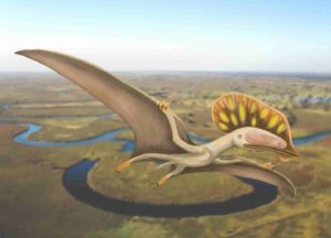
The attached image shows Wightia declivirostris flying over an oxbow lake in the valley of the ancient Wessex River that flowed from Devon to the Isle of Wight. Credit: Megan Jacobs
The first ever specimen of a pterodactyl, more commonly found in China and Brazil, has been found in the United Kingdom.
A fossil hunter recently discovered a peculiar shaped fragment of fossil bone while out walking his dog in Sandown Bay on the Isle of Wight.
Not sure what it was, he passed it to University of Portsmouth Palaeontology student Megan Jacobs, who thought it might be the jaw bone from a pterodactyl. Further research proved she was right.
However, this was no ordinary pterodactyl jaw. This one lacked teeth and was remarkably similar to a bizarre group of pterosaurs called ‘tapejarids’. They are better known from China and Brazil and have never previously been found in the UK.
Just last year a team from the University of Portsmouth discovered as similar specimen in North Africa (Morocco) which they named Afrotapejara.
The new specimen from the Isle of Wight has been named Wightia declivirostris.
Megan Jacobs said: “Although only a fragment of jaw, it has all the characteristic of a tapejarid jaw, including numerous tiny little holes that held minute sensory organs for detecting their food, and a downturned, finely pointed beak.
“Complete examples from Brazil and China show that they had large head crests, with the crest sometime being twice as big as the skull. The crests were probably used in sexual display and may have been brightly colored.”
The researchers determined that the Isle of Wight example seemed more closely related to the Chinese tapejarids rather than the Brazilian examples.
Co-author of the study Professor David Martill, a paleontologist from the University of Portsmouth, said: “This new species adds to the diversity of dinosaurs and other prehistoric reptiles found on the Island, which is now one of the most important places for Cretaceous dinosaurs in the world.”
The finder has kindly donated the specimen to Dinosaur Isle Museum at Sandown, where it is hoped it will go on display in the future.
Reference:
David M. Martill et al, First tapejarid pterosaur from the Wessex Formation (Wealden Group: Lower Cretaceous, Barremian) of the United Kingdom, Cretaceous Research (2020). DOI: 10.1016/j.cretres.2020.104487
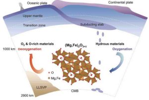
A schematic diagram of the Earth’s deep oxygen factory shows the oxygenation and deoxygenation processes of hydrous mantle materials in the lower mantle across the ~1000 km depth beneath Earth’s surface. Under the conditions of Earth’s middle mantle, scientists discovered an oxygen-excess phase, (Mg,Fe)2O3+δ (0 < δ < 1) that can be formed with under-saturated water at >1000 kilometers depths. Those oxygen-excess materials may have long-termly oxidized the shallow mantle and the crust, which is essential to allow free oxygen to build up in Earth’s atmosphere. Credit: Science China Press
Subduction of hydrous materials imposes great influence on the structure, dynamics, and evolution of our planet. However, it is largely unclear how subducting slabs chemically interact with the middle mantle. Recently, an oxygen-excess phas (Mg,Fe)2O3+δ was discovered under conditions similar to the Earth’s middle mantle (~1000-2000 km) by a team of scientists from the Center of High Pressure Science and Technology Advanced Research (HPSTAR) and Stanford University.
This oxygen-excess phase is fully recoverable to ambient conditions for ex-situ investigation using transmission electron microscopy. It contains ferric iron as in hematite (Fe2O3) which is the most oxidized form of iron on the Earth’s surface, but this new phase holds more oxygen than hematite through interactions between oxygen atoms. The peculiar nature of oxygen in this new phase may revise our view on the mantle redox chemistry.
“We employed laboratory techniques to simulate the conditions deep inside the Earth and found an oxygen-excess phase emerged when hydrous mineral assemblages (e.g., ferropericlase mixed with brucite) were exposed to laser heating at pressures greater than 40 million times the atmospheric pressure on the Earth’s surface” said Dr. Jin Liu from HPTAR. “The formation of this new phase provides strong evidence that water acts as a strong oxidant at high pressure.”
“This phase could coexist with the pyrite-type phase hydrogen-bearing FeO2 at deep mantle conditions, whereas the two phases are distinct in crystal chemistry,” added Dr. Qingyang Hu from HPSTAR. “Unlike the formation of the pyrite-type phase which usually forms in deep lower mantle and requires a large quantity of water, this oxygen-excess phase can be formed with a moderate amount of water at mid-mantle conditions. The flexible formation conditions make it potentially a more widespread phase at depths greater than 1000 km in Earth’s mantle, occupying almost 2/3 of the mantle.” Furthermore, this oxygen-excess phase can co-exist with the major mantle minerals, bridgmanite and ferropericlase, under Earth’s lower-mantle conditions.
“The widespread presence of the oxygen-excess phase makes it and other oxygen-enriched oxides an important subject for the full range of future geochemistry and mineral physics studies,” suggested Dr. Ho-kwang Mao, director of HPSTAR. “Remarkably, this new phase is quenchable. As a matter of fact, most compounds synthesized under the lower mantle conditions and quenchable back to ambient conditions have been discovered and named as minerals such as bridgmanite (Mg,Fe)SiO3 and seifertite SiO2. Hence, this presents an opportunity to search for this oxygen excess phase in nature as diamond inclusions or meteorite shock products.”
The crystal structure of this oxygen excess phase may represent a structure prototype which will accommodate other Earth-abundant components (e.g. Al, Ca, Ti, and Ni). At the same time, the channel space in this oxygen-excess phase could offer a great flexibility not only for excess oxygen, but also for other volatiles (e.g. N, S, F, and Cl). Considering its structural versatility, the new phase could be an important volatile carrier in the deep mantle over geological time. More importantly, together with excess Fe3+ from the primordial lower mantle, those oxygen-excess materials may have in the long term oxidized the shallow mantle and the crust, which is fundamental to the evolution and habitability of complex life on the Earth’s surface.
These results suggest that the oxygen-excess phase may facilitate oxygen-excess reservoirs out of hydrated slab remnants at depths greater than 1000 km. Oceanic crusts in the mid-mantle thus might deeply regulate the rise of oxygen in Earth’s atmosphere and global habitability, like shallowly-recycled fluids. Such intriguing chemistry of deep oxygen sheds light on chemical and dynamic models of mantle slab remnants as well as the interaction and coevolution of Earth’s interior and surface.
Reference:
Jin Liu et al, Evidence for oxygenation of Fe-Mg oxides at mid-mantle conditions and the rise of deep oxygen, National Science Review (2020). DOI: 10.1093/nsr/nwaa096
Note: The above post is reprinted from materials provided by Science China Press.
Normal and malformed spores from East Greenland. Credit: John Marshall
Researchers at the University of Southampton have shown that an extinction event 360 million years ago, that killed much of the Earth’s plant and freshwater aquatic life, was caused by a brief breakdown of the ozone layer that shields the Earth from damaging ultraviolet (UV) radiation. This is a newly discovered extinction mechanism with profound implications for our warming world today.
There have been a number of mass extinction in the geological past. Only one was caused by an asteroid hitting the Earth, which was 66 million years ago when the dinosaurs became extinct. Three of the others, including the end Permian Great Dying, 252 million years ago, were caused by huge continental scale volcanic eruptions that destabilised the Earth’s atmospheres and oceans.
Now, scientists have found evidence showing it was high levels of UV radiation which collapsed forest ecosystems and killed off many species of fish and tetrapods (our four limbed ancestors) at the end of the Devonian geological period, 359 million years ago. This damaging burst of UV radiation occurred as part of one of the Earth’s climate cycles, rather than being caused by a huge volcanic eruption.
The ozone collapse occurred as the climate rapidly warmed following an intense ice age and the researchers suggest that the Earth today could reach comparable temperatures, possibly triggering a similar event. Their findings are published in the journal Science Advances.
The team collected rock samples during expeditions to mountainous polar-regions in East Greenland, which once formed a huge ancient lake bed in the arid interior of the Old Red Sandstone Continent, made up of Europe and North America. This lake was situated in the Earth’s southern hemisphere and would have been similar in nature to modern day Lake Chad on the edge of the Sahara Desert.
Other rocks were collected from the Andean Mountains above Lake Titicaca in Bolivia. These South American samples were from the southern continent of Gondwana, which was closer to the Devonian South Pole. They held clues as to what was happening at the edge of the melting Devonian ice sheet, allowing a comparison between the extinction event close to the pole and close to the equator.
Back in the lab, the rocks were dissolved in hydrofluoric acid, releasing microscopic plant spores (like pollen, but from fern like plants that didn’t have seeds or flowers) which had lain preserved for hundreds of millions of years. On microscopic examination, the scientists found many of the spores had bizarrely formed spines on their surface — a response to UV radiation damaging their DNA. Also, many spores had dark pigmented walls, thought to be a kind of protective ‘tan’, due to increased and damaging UV levels.
The scientists concluded that, during a time of rapid global warming, the ozone layer collapsed for a short period, exposing life on Earth to harmful levels of UV radiation and triggering a mass extinction event on land and in shallow water at the Devonian-Carboniferous boundary.
Following melting of the ice sheets, the climate was very warm, with the increased heat above continents pushing more naturally generated ozone destroying chemicals into the upper atmosphere. This let in high levels of UV-B radiation for several thousand years.
Lead researcher Professor John Marshall, of the University of Southampton’s School of Ocean and Earth Science, who is a National Geographic Explorer, comments: “Our ozone shield vanished for a short time in this ancient period, coinciding with a brief and quick warming of the Earth. Our ozone layer is naturally in a state of flux — constantly being created and lost — and we have shown this happened in the past too, without a catalyst such as a continental scale volcanic eruption.”
During the extinction, plants selectively survived, but were enormously disrupted as the forest ecosystem collapsed. The dominant group of armoured fish became extinct. Those that survived — sharks and bony fish — remain to this day the dominant fish in our ecosystems.
These extinctions came at a key time for the evolution of our own ancestors, the tetrapods. These early tetrapods are fish that evolved to have limbs rather than fins, but still mostly lived in water. Their limbs possessed many fingers and toes. The extinction reset the direction of their evolution with the post-extinction survivors being terrestrial and with the number of fingers and toes reduced to five.
Professor Marshall says his team’s findings have startling implications for life on Earth today: “Current estimates suggest we will reach similar global temperatures to those of 360 million years ago, with the possibility that a similar collapse of the ozone layer could occur again, exposing surface and shallow sea life to deadly radiation. This would move us from the current state of climate change, to a climate emergency.”
The remote locations visited in East Greenland are very difficult to access, with travel involving light aircraft capable of landing directly on the tundra. Transport within the vast field area was by inflatable boats equipped with outboard motors, all of which had to fit in the small aircraft.
All field logistics was organised by CASP, an independent charitable trust based in Cambridge specialising in remote geological fieldwork. Mike Curtis, Managing Director of CASP says: “We have a history of assisting research geologists such as John Marshall and colleagues to access remote field areas and we are particularly pleased that their research has proved to have such potentially profound implications.”
Reference:
John E. A. Marshall, Jon Lakin, Ian Troth, Sarah M. Wallace-Johnson. UV-B radiation was the Devonian-Carboniferous boundary terrestrial extinction kill mechanism. Science Advances, 2020; 6 (22): eaba0768 DOI: 10.1126/sciadv.aba0768
Subduction zones occur where one tectonic plate dives under another. New computer modeling by Magali Billen, professor of earth and planetary sciences at UC Davis, shows why earthquakes on these sinking plates cluster at certain depths and could give insight into processes deep in the Earth. (U.S. Geological Survey)
A new understanding of our planet’s deepest earthquakes could help unravel one of the most mysterious geophysical processes on Earth.
Deep earthquakes — those at least 300 kilometers below the surface — don’t typically cause damage, but they are often widely felt. These earthquakes can provide vital clues to understanding plate tectonics and the structure of the Earth’s interior. Due to the extremely high temperature and pressures where deep earthquakes occur, they likely stem from different physical and chemical processes than earthquakes near the surface. But it’s hard to gather information about deep earthquakes, so scientists don’t have a solid explanation for what causes them.
“We can’t directly see what’s happening where deep earthquakes occur,” said Magali Billen, professor of geophysics in the UC Davis Department of Earth and Planetary Sciences.
What’s driving deep earthquakes?
Billen builds numerical simulations of subduction zones, where one plate sinks below another, to better understand the forces controlling plate tectonics. Her recent work helps explain the distribution of deep earthquakes, showing that they most often strike in regions of “high strain” where a sinking tectonic plate bends and folds.
“These models provide compelling evidence that strain rate is an important factor in controlling where deep earthquakes occur,” she said.
The new understanding that deformation is a major factor in deep earthquakes should help scientists resolve which mechanisms trigger deep earthquakes and can provide new constraints on subduction zone structure and dynamics, Billen said.
“Once we understand deep earthquake physics better, we will be able to extract even more information about the dynamics of subduction, the key driver of plate tectonics,” she said.
Her findings were published May 27 in the journal Science Advances.
New way to study deep earthquakes
Deep earthquakes occur in subduction zones — where one of the tectonic plates floating on the surface of the Earth dives under another and is “subducted” into the mantle. Within the sinking slabs of crust, earthquakes cluster at some depths and are sparse in others. For example, many slabs exhibit large gaps in seismic activity below 410 kilometers in depth.
The gaps in seismicity line up with regions of the slab that are deforming more slowly in the numerical models, Billen said.
“Deformation is not the same everywhere in the plate,” Billen said. “That’s really what’s new here.”
Billen’s research was not originally intended to investigate deep earthquakes. Rather, she was trying to understand the slow back-and forth motion of deep ocean trenches, where plates bend downward in subduction zones.
“I decided out of curiosity to plot the deformation in the plate, and when I looked at the plot, the first thing that popped in my mind was ‘wow, this looks like the distribution of deep earthquakes,'” she said. “It was a total surprise.”
Mimicking the deep Earth
Billen’s model incorporates the latest data about phenomena such as the density of minerals, different layers in the sinking plate, and experimental observations of how rocks behave at high temperatures and pressures.
“This is the first model that really brings together the physical equations that describe the sinking of the plates and key physical properties of the rocks,” Billen said.
The results cannot distinguish between possible causes for deep earthquakes. However, they do provide new ways to explore what causes them, Billen said.
“Taking into account the added constraint of strain-rate should help to resolve which mechanisms are active in the subducting lithosphere, with the possibility that multiple mechanisms may be required,” she said.
The project was supported by a fellowship from the Alexander von Humboldt Foundation and an award from the National Science Foundation. The Computational Infrastructure for Geodynamics supports the CitcomS software used for the numerical simulations.
Reference:
Magali I. Billen. Deep slab seismicity limited by rate of deformation in the transition zone. Science Advances, 2020; 6 (22): eaaz7692 DOI: 10.1126/sciadv.aaz7692
Big theropod dinosaurs such as Allosaurus and Ceratosaurus ate pretty much everything — including each other, according to a new study. Credit: PLOS ONE
Big theropod dinosaurs such as Allosaurus and Ceratosaurus ate pretty much everything—including each other, according to a new study, “High Frequencies of Theropod Bite Marks Provide Evidence for Feeding, Scavenging, and Possible Cannibalism in a Stressed Late Jurassic Ecosystem,” published last month in the journal PLOS ONE.
“Scavenging, and even cannibalism, is pretty common among modern predators,” said lead author Stephanie Drumheller, a paleontologist in the University of Tennessee, Knoxville’s Department of Earth and Planetary Sciences. “Big theropods, like Allosaurus, probably weren’t particularly picky eaters if it meant they got a free meal.”
Researchers surveyed more than 2,000 bones from the Jurassic Mygatt-Moore Quarry, a 152-million-year-old fossil deposit in western Colorado, looking for bite marks. They found more than they were expecting.
There were theropod bites on the large-bodied sauropods whose gigantic bones dominate the assemblage, bites on the heavily armored Mymoorapelta, and lots of bites on theropods, too, especially the common remains of Allosaurus. There were hundreds of them, in frequencies far above the norm for dinosaur-dominated fossil sites.
Some were on meaty bones like ribs, but researchers discovered others on tiny toe bones, far from the choicest cuts. Pulled together, the data paints a picture of an ecosystem where dinosaur remains lay out on the landscape for months at a time—a stinky prospect, but one that gave a whole succession of predators and scavengers a turn at eating.
But why were there so many bites on the Mygatt-Moore bones? That question is a little harder to answer, at least without similar surveys from other dinosaur sites for comparison.
The Mygatt-Moore Quarry itself is a little unusual.
Volunteer members of the public have excavated most of the fossils found at the quarry. Julia McHugh, curator of paleontology with the Museums of Western Colorado and a co-author of the study, decided to continue this tradition of outreach by bringing students into the lab to help with the project. Now two of them, Miriam Kane and Anja Riedel, are co-authors on the new study as well.
“Mygatt-Moore is such a unique place,” McHugh said. “Science happens here alongside hands-on STEM education with our dig program and volunteers.”
Having so many marks on hand let the researchers really dig into details that are sometimes harder to study in smaller collections. For example, theropod teeth are serrated, and once in a while the tooth shape is reflected in the bite marks they make. Another co-author, Domenic D’Amore of Daemen College, had earlier figured out a way to translate those striated tooth marks into body size estimates.
“We can’t always tell exactly what species were marking up the Mygatt-Moore bones, but we can say many of these marks were made by something big,” D’Amore said. “A few may have been made by theropods larger than any found at the site before.”
For more than 30 years, researches and others have worked the Mygatt-Moore Quarry intensively, but even after all that time, each season brings new discoveries in the field and in the lab. This snapshot of dinosaur behavior is proof that old bones can still hold scientific surprises.
Reference:
Drumheller SK, McHugh JB, Kane M, Riedel A, D’Amore DC (2020) High frequencies of theropod bite marks provide evidence for feeding, scavenging, and possible cannibalism in a stressed Late Jurassic ecosystem. PLoS ONE 15(5): e0233115. doi.org/10.1371/journal.pone.0233115
Scientists are finding that Earth’s mantle may have generated the planet’s early magnetic field. Credit: Naeblys
If we took a journey from Earth’s surface to the center, the midway point is roughly at 1900 km depth in the lower mantle. The lower mantle ranges from 660 to 2900 km depth and occupies 55% of our planet by volume. The chemical composition of the lower mantle is rather simple. It has long been pictured as being made up of 2 major minerals (~95%), namely bridgmanite and ferropericlase. Recently, this model was directly challenged by a set of discoveries in the lower mantle.
“One of the major lower mantle compositions, ferropericlase (Mg, Fe)O, turns into a pyrite-type structure upon meeting water. This intriguing chemical reaction only occurs at Earth’s deep lower mantle which is defined in depths between 1900 and 2900 km,” said Qingyang Hu from HPSTAR. “The reaction produces so-called oxygen excessive phases, or simply superoxides. The lower mantle is oxidized in the presence of water.” Generally, when all the oxygen atoms in a compound are bonded with metal atoms, they are called oxides. However, if a compound has paired oxygen atoms, like oxygen-oxygen bonding, it becomes a superoxide. Although superoxide is rarely found in nature, it might be common in Earth’s deep lower mantle.
“We also found that olivine and its high-pressure phase wadsleyite, the dominating minerals in the upper mantle, decompose to generate superoxides when subducting down into the deep mantle with water,” added by Jin Liu from at HPSTAR. Few approaches are available for scientists to probe the lower mantle mineralogy, given its depth. “Our experiments are very challenging. We input appropriate parameters like pressure, temperature, and starting minerals. Then we investigated the outputs including chemical reactions, new mineral assemblages, and their density profiles. Those parameters allow us to better constrain the nature of the lower mantle and its oxidation state. Contrary to the paradigm that the lower mantle is highly reduced, our results indicate that the deep lower mantle is at least locally oxidized wherever water is present.”
The team members proceeded with minerals existing on Earth’s surface, by squeezing them between two pieces of diamond anvils to generate about 100,000,000 times the atmospheric pressure at sea level, heating them up using an infrared laser, before analyzing the samples using a battery of X-ray and electron probes. The experiments have mimicked the extreme pressure-temperatures conditions found in Earth’s deep lower mantle.
Previous experiments explored a dry mineral assembly in the absence of water. Those experiments reported that bridgmanite (and/or post-bridgmanite) and ferropericlase are the most abundant and stable minerals throughout the lower mantle. However, when water is introduced, ferropericlase would be partially oxidized to superoxide under the deep lower mantle conditions. The superoxide is verified to stay in harmony with bridgmanite and post-bridgmanite.
This new water-mantle chemistry can be closely linked to the water cycling in the solid Earth. Every year, billions of tons of ocean water falls into the deep Earth at tectonic plate boundaries. While some water returns via underwater volcanoes and hot vents, some goes deep into the Earth’s interior. “Our experiments indicate the deep water is an essential part of mantle chemistry. The water cycling can extend to the deep lower mantle where water has extraordinary oxidation power, producing highly oxidized superoxide and releasing hydrogen,” suggested Dr. Ho-kwang Mao from HPSTAR. “The lower mantle can be oxidized and reduced at the same time.”
Reference:
Qingyang Hu et al, Mineralogy of the deep lower mantle in the presence of H2O, National Science Review (2020). DOI: 10.1093/nsr/nwaa098
Note: The above post is reprinted from materials provided by Science China Press.
Original artwork depicting the moment the asteroid struck in present-day Mexico. Credit: Chase Stone
The simulations show that the asteroid hit Earth at an angle of about 60 degrees, which maximised the amount of climate-changing gases thrust into the upper atmosphere.
Such a strike likely unleashed billions of tonnes of sulphur, blocking the sun and triggering the nuclear winter that killed the dinosaurs and 75 per cent of life on Earth 66 million years ago.
Drawn from a combination of 3D numerical impact simulations and geophysical data from the site of the impact, the new models are the first ever fully 3D simulations to reproduce the whole event — from the initial impact to the moment the final crater, now known as Chicxulub, was formed.
The simulations were performed on the Science and Technology Facilities Council (STFC) DiRAC High Performance Computing Facility.
Lead researcher Professor Gareth Collins, of Imperial’s Department of Earth Science and Engineering, said: “For the dinosaurs, the worst-case scenario is exactly what happened. The asteroid strike unleashed an incredible amount of climate-changing gases into the atmosphere, triggering a chain of events that led to the extinction of the dinosaurs. This was likely worsened by the fact that it struck at one of the deadliest possible angles.
“Our simulations provide compelling evidence that the asteroid struck at a steep angle, perhaps 60 degrees above the horizon, and approached its target from the north-east. We know that this was among the worst-case scenarios for the lethality on impact, because it put more hazardous debris into the upper atmosphere and scattered it everywhere — the very thing that led to a nuclear winter.”
The results are published today in Nature Communications.
Crater creation
The upper layers of earth around the Chicxulub crater in present-day Mexico contain high amounts of water as well as porous carbonate and evaporite rocks. When heated and disturbed by the impact, these rocks would have decomposed, flinging vast amounts of carbon dioxide, sulphur and water vapour into the atmosphere.
The sulphur would have been particularly hazardous as it rapidly forms aerosols — tiny particles that would have blocked the sun’s rays, halting photosynthesis in plants and rapidly cooling the climate. This eventually contributed to the mass extinction event that killed 75 per cent of life on Earth.
The team of researchers from Imperial, the University of Freiburg, and The University of Texas at Austin, examined the shape and subsurface structure of the crater using geophysical data to feed into the simulations that helped diagnose the impact angle and direction. Their analysis was also informed by recent results from drilling into the 200 km-wide crater, which brought up rocks containing evidence of the extreme forces generated by the impact.
Peak performance
Pivotal to diagnosing the angle and direction of impact was the relationship between the centre of the crater, the centre of the peak ring — a ring of mountains made of heavily fractured rock inside the crater rim — and the centre of dense uplifted mantle rocks, some 30 km beneath the crater.
At Chicxulub, these centres are aligned in a southwest-northeast direction, with the crater centre in between the peak-ring and mantle-uplift centres. The team’s 3D Chicxulub crater simulations at an angle of 60 degrees reproduced these observations almost exactly.
The simulations reconstructed the crater formation in unprecedented detail and give us more clues as to how the largest craters on Earth are formed. Previous fully 3D simulations of the Chicxulub impact have covered only the early stages of impact, which include the production of a deep bowl-shaped hole in the crust known as the transient crater and the expulsion of rocks, water and sediment into the atmosphere.
These simulations are the first to continue beyond this intermediate point in the formation of the crater and reproduce the final stage of the crater’s formation, in which the transient crater collapses to form the final structure. This allowed the researchers to make the first comparison between 3D Chicxulub crater simulations and the present-day structure of the crater revealed by geophysical data.
Co-author Dr Auriol Rae of the University of Freiburg said: “Despite being buried beneath nearly a kilometre of sedimentary rocks, it is remarkable that geophysical data reveals so much about the crater structure — enough to describe the direction and angle of the impact.”
The researchers say that while the study has given us important insights into the dinosaur-dooming impact, it also helps us understand how large craters on other planets form.
Co-author Dr Thomas Davison, also of Imperial’s Department of Earth Science and Engineering, said: “Large craters like Chicxulub are formed in a matter of minutes, and involve a spectacular rebound of rock beneath the crater. Our findings could help advance our understanding of how this rebound can be used to diagnose details of the impacting asteroid.”
Reference:
Collins, G.S., Patel, N., Davison, T.M. et al. A steeply-inclined trajectory for the Chicxulub impact. Nat Commun, 2020 DOI: 10.1038/s41467-020-15269-x
The rising Earth from the perspective of the moon. Credit: NASA Goddard
University of Liverpool scientists are part of an ambitious research project to map conditions underneath the surface of the Earth in unprecedented detail.
Combining state-of-the-art technology with the latest high-performance computing, the University is part of a team of nine universities, led by Cardiff University, that aims to create the very first 4-D maps of the Earth’s mantle—a huge layer of slowly moving rock that sits beneath our surface.
This circulation of rock has quite literally shaped the world we live in today, from our islands and continents to our mountain ranges and ocean floor ridges, and therefore holds the blueprint for how our planet has evolved.
The team aims to create computerized maps of the flow of the Earth’s mantle over the past 1 billion years, representing the temperature, density, and velocity of the mantle over that time period, providing a complete 4-D model.
Professor of Palaeomagnetism, Andy Biggin, who heads up the University’s Geomagnetism Laboratory and the Determining Earth Evolution from Palaeomagnetism (DEEP) research group, is leading Liverpool’s involvement in the project. He said: “It is extremely exciting that we will contribute to this ambitious and highly multidisciplinary project aiming to produce the world’s most realistic dynamical models of circulation within Earth’s mantle.
“Any self-consistent model of motion in Earth’s thick rocky layer would be incomplete if it did not also plausibly account for observed changes in the planet’s magnetic field generated in the underlying core. The role of the Liverpool’s DEEP team will be to generate state-of-the-art palaeomagnetic records and models to provide this critical constraint.”
Principal researcher on the project, Professor Huw Davies from Cardiff University, said: “Just like discovering DNA opened up our understanding of biology, mapping the mantle flow will open up our understanding of how the Earth has been shaped across its history.”
The theory of plate tectonics, the division of Earth’s outer shell into several gliding plates, has revolutionized the sciences and allowed us to truly understand the motion of Earth’s surface.
Yet, plate tectonic theory does not tell us about the processes deeper in the Earth that drive plate motions, nor does it explain some of the most dramatic events in Earth history, such as the breakup of plates, the outpouring of huge volumes of lava and mass extinction events.
The Earth’s mantle functions like one giant plumbing system where heat is transferred up from the hot core to the surface and then back again, in one big cycle. This transfer of heat via upflow and downflow, known as upwelling and downwelling, is facilitated by the rocks in the mantle which move at extremely slow speeds—roughly the same speed that a fingernail grows.
The process of upwelling, the movement of heat up from the core, remains much of a mystery to scientists, particularly how it correlates with the movement of tectonic plates, and will be the main focus of this research project.
Upwelling is also of great interest to scientists as there are regions or ‘hotspots’ on the surface of the Earth where it has historically resulted in the outpouring of huge amounts of lava, ashes and gases into the atmosphere that have had devastating impacts on life on Earth.
These areas, known as Large Igneous Provinces (LIPs), are now seen as deposits of igneous rocks that can cover thousands of square kilometers and are hundreds of meters thick.
For example, the Deccan Traps, an LIP that covered a large part of India, was partly responsible, together with a major meteorite impact in Mexico, for the demise of the dinosaurs, whilst another LIP, the Siberian Traps, was responsible for the largest extinction event ever of life on Earth.
As part of the study, the team will for the first time have access to a record of plate motion of the past 1 billion years of Earth’s history. This data will be combined with seismic imaging from earthquakes that have happened in the past and that are currently occurring, which will provide information on the speed at which seismic waves move through the mantle and therefore act much like a medical scan and provide an ‘image’ of the interior.
Professor Davies added: “By combining all of this information, we will have a much clearer understanding of how our planet works. The 4-D visualizations that the project will produce will be of great interest to a wide variety of research areas and industries, from the exploration of mineral resources to understanding how large-scale events in the past shaped our climate and therefore underpin more robust predictions of future climate change.”
This project continues a close collaboration between Liverpool and the University of Leeds working to explain past variations in the long term behavior of Earth’s magnetic field which has been supported by The Leverhulme Trust and NERC.
Professor Biggin will manage one of the three work packages of the project—Evolution of mantle flow—which combines dynamic topography, geochemistry, petrology and geomagnetism to provide time-dependent constraints on the models generated.
Earth’s mantle (dark red) lies below the crust (brown layer near the surface) and above the outer core (bright red). Credit: CC image by Argonne National Laboratory via Flickr
The National Science Foundation should invest in new initiatives, partnerships and infrastructure to answer 12 priority research questions relevant to society in the next decade, according to a new report from the National Academies of Sciences, Engineering, and Medicine. A Vision for NSF Earth Sciences 2020-2030: Earth in Time says that a scientifically and demographically diverse group of researchers will be required to answer the questions.
“Geologic understanding of the earth has profound implications for people all across the globe,” said James A. Yoder, dean emeritus of Woods Hole Oceanographic Institution and chair of the committee that authored the report.
“The 12 questions all have a direct bearing on societal needs,” said Paul Olsen, a geologist at Columbia University’s Lamont-Doherty Earth Observatory and member of the committee. “Understanding that the earth is a system and analyzing it in that capacity reflects the interconnection between climate, life, and the deeper earth.”
Some of the recommended questions go to enhancing our basic understanding of the planet, such as when and how plate tectonics developed; how geologic processes influence biodiversity; and how critical chemical elements are distributed and cycled. But all aim to advance understanding of how the earth impacts society. Other questions: What is an earthquake? What drives volcanism? What does the past reveal about the dynamics of the climate system? How is the Earth’s water cycle changing? How can earth science reduce the toll of geohazards?
The NSF’s Division of Earth Science (EAR) is the primary federal group for funding and providing essential infrastructure capabilities to the earth science community. The report recommends that EAR undertake initiatives to address gaps between existing and needed infrastructure. Several of these initiatives, such as funding a national consortium for geochronology, focus on supporting collaborative research. EAR should also fund facilities that provide new access to technical capabilities, such as a giant press to study rock and mineral behavior under pressure, and a near-surface geophysics center, says the report. These initiatives should not be developed at the expense of EAR’s core disciplinary research programs, and will require new funding, it says.
Highly trained STEM professionals will be central to future breakthroughs, but the field faces challenges in recruiting and retaining an inclusive workforce. The report recommends that EAR enhance its existing efforts to provide investment and centralized guidance to improve diversity and equity. EAR should also fund technical staff for grantees on a long-term basis, the authors say.
All the priority questions will require advances in high-performance computing, improved modeling capabilities, and enhanced data curation. EAR should initiate a standing committee to advise on cyber infrastructure needs, and implement a strategy to support data standards across the research community, the report says.
The authors say that joining with other federal agencies and NSF divisions, and international partners will allow for more efficient leveraging of facilities and infrastructure.
Picture of the Santa Maria volcano in Guatemala. Credit: Zorn et al. 2020, Nature
Due to the difficult accessibility and the high risk of collapse or explosion, the imaging of active volcanoes has so far been a great challenge in volcanology. Researchers around Edgar Zorn from the German Research Centre for Geosciences GFZ in Potsdam are now presenting the results of a series of repeated survey flights with optical and thermal imaging cameras at the Santa Maria volcano in Guatemala. Drones were used to observe the lava dome, a viscous plug of lava. The researchers were able to show that the lava dome shows movements on two different time scales: slow expansion and growth of the dome and fast extrusion of viscous lava. The study was published in the journal “Scientific Reports.”
“We have equipped a drone with different cameras,” says Edgar Zorn from GFZ, the first author of the study. “We then flew the drone over the crater at various intervals, measuring the movements of lava flow and a lava dome using a specific type of stereo photography with a precision never seen before.” By comparing the data from the drone, we were able to determine the flow velocity, movement patterns and surface temperature of the volcano. These parameters are important for predicting the danger of explosive volcanoes. The researchers also succeeded in deriving the flow properties of the lava from these data.
“We have shown that the use of drones can help to completely re-measure even the most dangerous and active volcanoes on Earth from a safe distance,” continues Edgar Zorn. “A regular and systematic survey of dangerous volcanoes with drones seems to be almost within one’s grasp,” says Thomas Walter, volcanologist at GFZ, who was also involved in the study.
The two cameras of the drone used on the Caliente volcanic cone of the Santa Maria volcano were able to take high-resolution photos on the one hand and thermal imaging on the other. Using a special computer algorithm, the researchers were able to create complete and detailed 3D models from these images. They obtained a 3D topography and temperature model of the volcano with a resolution of only a few centimetres.
Drone missions considerably reduce the risk for volcanologists, as the cameras can be flown directly to the dangerous spots without the scientists having to go near them themselves. Instead, the greatest challenge lies in the post-processing and calculation of the models. “The 3D models of the various flights must be positioned exactly so that they can be compared. This requires painstaking detail work, but the effort is worth it because even minimal movements become immediately visible,” says Edgar Zorn. “In the study, we presented some new possibilities for the representation and measurement of certain ground movements, which could be very useful in future projects.”
Reference:
Edgar U. Zorn, Thomas R. Walter, Jeffrey B. Johnson, René Mania. UAS-based tracking of the Santiaguito Lava Dome, Guatemala. Scientific Reports, 2020; 10 (1) DOI: 10.1038/s41598-020-65386-2
An artistic life reconstruction of Nannopterygius. Credit: Andrey Atuchin
A Russian paleontologist visiting the Natural History Museum in London desperately wanted a good look at the skeleton of an extinct aquatic reptile, but its glass case was too far up the wall. So he attached his digital camera to a fishing rod and — with several clicks — snagged a big one, scientifically speaking.
Images from the “selfie stick” revealed that the creature, whose bones were unearthed more than a century ago on a coast in southern England, seemed very similar to a genus of ichthyosaurs he recognized from Russian collections.
He emailed the photos of the dolphin-like ichthyosaur to fellow paleontologist Megan L. Jacobs, a Baylor University doctoral candidate in geosciences. She quickly realized that the animal’s skeletal structure matched not only some ichthyosaurs she was studying in a fossil museum on the English Channel coast, but also some elsewhere in the United Kingdom.
Jacobs and paleontologist Nikolay G. Zverkov of the Russian Academy of Sciences — who “fished” for the ichthyosaur — merged their research, studying their collective photos and other materials and ultimately determining that the Russian and English ichthyosaurs were of the same genus and far more common and widespread than scientists believed.
Their study is published in the Zoological Journal of the Linnean Society.
“Ichthyosaurs swam the seas of our planet for about 76 million years,” Jacobs said. “But this 5-foot ichthyosaur from some 150 million years ago was the least known and believed to be among the rarest ichthyosaurs. The skeleton in the case, thought to be the only example of the genus, has been on display in the Natural History Museum in London since 1922.
“Nikolay’s excellent detailed photos significantly expand knowledge of Nannopterygius enthekiodon,” she said. “Now, after finding examples from museum collections across the United Kingdom, Russia and the Arctic — as well as several other Nannopterygius species — we can say Nannopterygius is one of the most widespread genera of ichthyosaurs in the Northern Hemisphere.”
Additionally, the study described a new species, Nannopterygius borealis, dating from about 145 million years ago in a Russian archipelago in the Arctic. The new species is the northernmost and youngest representative of its kind, Jacobs said.
Previously, for the Middle and Late Jurassic epochs, the only abundant and most commonly found ichthyosaur was Ophthalmosaurus, which had huge eyes and was about 20 feet long. It was known from hundreds of specimens, including well-preserved skeletons from the Middle Jurassic Oxford Clay Formation of England, Jacobs said.
“For decades, the scientific community thought that Nannopterygius was the rarest and most poorly known ichthyosaur of England,” Zverkov said. “Finally, we can say that we know nearly every skeletal detail of these small ichthyosaurs and that these animals were widespread. The answer was very close; what was needed was just a fishing rod.”
Reference:
Nikolay G Zverkov; Megan L Jacobs. Revision of Nannopterygius (Ichthyosauria: Ophthalmosauridae): reappraisal of the ‘inaccessible’ holotype resolves a taxonomic tangle and reveals an obscure ophthalmosaurid lineage with a wide distribution. Zoological Journal of the Linnean Society, 2020 DOI: 10.1093/zoolinnean/zlaa028
Researchers developed a technique that allows them to study the atomic arrangements of liquid silicates at the extreme conditions found in the core-mantle boundary. This could lead to a better understanding of the Earth’s early molten days, which could even extend to other rocky planets. Credit: Greg Stewart/SLAC National Accelerator Laboratory
Far below the Earth’s surface, about 1,800 miles deep, lies a roiling magmatic region sandwiched between the solid silicate-based mantle and molten iron-rich core: The core-mantle boundary. It’s a remnant of olden times, the primordial days about 4.5 billion years ago when the entire planet was molten, an endless sea of magma. Although the region’s extreme pressures and temperatures make it difficult to study, it contains clues about the mysterious origin story of the world as we know it.
“We’re still trying to piece together how the Earth actually started to form, how it transformed from a molten planet to one with living creatures walking around on its silicate mantle and crust,” says Arianna Gleason, a scientist at the Department of Energy’s SLAC National Accelerator Laboratory. “Learning about the strange ways materials behave under different pressures can give us some hints.”
Now, scientists have developed a way to study liquid silicates at the extreme conditions found in the core-mantle boundary. This could lead to a better understanding of the Earth’s early molten days, which could even extend to other rocky planets. The research was led by scientists Guillaume Morard and Alessandra Ravasio. The team, which included Gleason and other researchers from SLAC and Stanford University, published their findings this week in the Proceedings of the National Academy of Sciences.
“There are features of liquids and glasses, in particular silicate melts, that we don’t understand,” says Morard, a scientist at the University of Grenoble and Sorbonne University in France. “The problem is that molten materials are intrinsically more challenging to study. Through our experiments we were able to probe geophysical materials at the extremely high temperatures and pressures of deep Earth to tackle their liquid structure and learn how they behave. In the future we will be able to use these types of experiments to recreate the first moments of Earth and understand the processes that shaped it.”
Hotter than the sun
At SLAC’s Linac Coherent Light Source (LCLS) X-ray free-electron laser, the researchers first sent a shockwave through a silicate sample with a carefully tuned optical laser. This allowed them to reach pressures that mimic those at the Earth’s mantle, 10 times higher than previously achieved with liquid silicates, and temperatures as high as 6,000 Kelvin, slightly hotter than the surface of the sun.
Next, the researchers hit the sample with ultrafast X-ray laser pulses from LCLS at the precise moment the shockwave reached the desired pressure and temperature. Some of the X-rays then scattered into a detector and formed a diffraction pattern. Just like every person has their own set of fingerprints, the atomic structure of materials is often unique. Diffraction patterns reveal that material fingerprint, allowing the researchers to follow how the sample’s atoms rearranged in response to the increase of pressure and temperature during the shockwave. They compared their results to those of previous experiments and molecular simulations to reveal a common evolutionary timeline of glasses and liquid silicates at high pressure.
“It’s exciting to be able to gather all these different techniques and get similar results,” says SLAC scientist and co-author Hae Ja Lee. “This allows us to find a combined framework that makes sense and take a step forward. It’s very comprehensive compared to other studies.”
Connecting the atomistic to the planetary
In the future, the LCLS-II upgrade, as well as upgrades to the Matter in Extreme Conditions (MEC) instrument where this research was performed, will allow scientists to recreate the extreme conditions found in the inner and outer core to learn about how iron behaves and the role it plays in generating and shaping Earth’s magnetic field.
To follow up on this study, the researchers plan to perform experiments at higher X-ray energies to make more precise measurements of the atomic arrangement of liquid silicates. They also hope to reach higher temperatures and pressures to gain insight into how these processes unfold in planets bigger than Earth, so-called super-Earths or exoplanets, and how the size and location of a planet influences its composition.
“This research allows us to connect the atomistic to the planetary,” Gleason says. “As of this month, more than 4,000 exoplanets have been discovered, about 55 of which are positioned in the habitable zone of their stars where it’s possible for liquid water to exist. Some of those have evolved to the point where we believe there’s a metallic core that could generate magnetic fields, which shield planets from stellar winds and cosmic radiation. There are so many pieces that need to fall into place for life to form and be sustained. Making the important measurements to better understand the construction of these planets is crucial in this age of discovery.”
Reference:
Guillaume Morard et al, In situ X-ray diffraction of silicate liquids and glasses under dynamic and static compression to megabar pressures, Proceedings of the National Academy of Sciences (2020). DOI: 10.1073/pnas.1920470117