Big theropod dinosaurs such as Allosaurus and Ceratosaurus ate pretty much everything — including each other, according to a new study. Credit: PLOS ONE
Big theropod dinosaurs such as Allosaurus and Ceratosaurus ate pretty much everything—including each other, according to a new study, “High Frequencies of Theropod Bite Marks Provide Evidence for Feeding, Scavenging, and Possible Cannibalism in a Stressed Late Jurassic Ecosystem,” published last month in the journal PLOS ONE.
“Scavenging, and even cannibalism, is pretty common among modern predators,” said lead author Stephanie Drumheller, a paleontologist in the University of Tennessee, Knoxville’s Department of Earth and Planetary Sciences. “Big theropods, like Allosaurus, probably weren’t particularly picky eaters if it meant they got a free meal.”
Researchers surveyed more than 2,000 bones from the Jurassic Mygatt-Moore Quarry, a 152-million-year-old fossil deposit in western Colorado, looking for bite marks. They found more than they were expecting.
There were theropod bites on the large-bodied sauropods whose gigantic bones dominate the assemblage, bites on the heavily armored Mymoorapelta, and lots of bites on theropods, too, especially the common remains of Allosaurus. There were hundreds of them, in frequencies far above the norm for dinosaur-dominated fossil sites.
Some were on meaty bones like ribs, but researchers discovered others on tiny toe bones, far from the choicest cuts. Pulled together, the data paints a picture of an ecosystem where dinosaur remains lay out on the landscape for months at a time—a stinky prospect, but one that gave a whole succession of predators and scavengers a turn at eating.
But why were there so many bites on the Mygatt-Moore bones? That question is a little harder to answer, at least without similar surveys from other dinosaur sites for comparison.
The Mygatt-Moore Quarry itself is a little unusual.
Volunteer members of the public have excavated most of the fossils found at the quarry. Julia McHugh, curator of paleontology with the Museums of Western Colorado and a co-author of the study, decided to continue this tradition of outreach by bringing students into the lab to help with the project. Now two of them, Miriam Kane and Anja Riedel, are co-authors on the new study as well.
“Mygatt-Moore is such a unique place,” McHugh said. “Science happens here alongside hands-on STEM education with our dig program and volunteers.”
Having so many marks on hand let the researchers really dig into details that are sometimes harder to study in smaller collections. For example, theropod teeth are serrated, and once in a while the tooth shape is reflected in the bite marks they make. Another co-author, Domenic D’Amore of Daemen College, had earlier figured out a way to translate those striated tooth marks into body size estimates.
“We can’t always tell exactly what species were marking up the Mygatt-Moore bones, but we can say many of these marks were made by something big,” D’Amore said. “A few may have been made by theropods larger than any found at the site before.”
For more than 30 years, researches and others have worked the Mygatt-Moore Quarry intensively, but even after all that time, each season brings new discoveries in the field and in the lab. This snapshot of dinosaur behavior is proof that old bones can still hold scientific surprises.
Reference:
Drumheller SK, McHugh JB, Kane M, Riedel A, D’Amore DC (2020) High frequencies of theropod bite marks provide evidence for feeding, scavenging, and possible cannibalism in a stressed Late Jurassic ecosystem. PLoS ONE 15(5): e0233115. doi.org/10.1371/journal.pone.0233115
Scientists are finding that Earth’s mantle may have generated the planet’s early magnetic field. Credit: Naeblys
If we took a journey from Earth’s surface to the center, the midway point is roughly at 1900 km depth in the lower mantle. The lower mantle ranges from 660 to 2900 km depth and occupies 55% of our planet by volume. The chemical composition of the lower mantle is rather simple. It has long been pictured as being made up of 2 major minerals (~95%), namely bridgmanite and ferropericlase. Recently, this model was directly challenged by a set of discoveries in the lower mantle.
“One of the major lower mantle compositions, ferropericlase (Mg, Fe)O, turns into a pyrite-type structure upon meeting water. This intriguing chemical reaction only occurs at Earth’s deep lower mantle which is defined in depths between 1900 and 2900 km,” said Qingyang Hu from HPSTAR. “The reaction produces so-called oxygen excessive phases, or simply superoxides. The lower mantle is oxidized in the presence of water.” Generally, when all the oxygen atoms in a compound are bonded with metal atoms, they are called oxides. However, if a compound has paired oxygen atoms, like oxygen-oxygen bonding, it becomes a superoxide. Although superoxide is rarely found in nature, it might be common in Earth’s deep lower mantle.
“We also found that olivine and its high-pressure phase wadsleyite, the dominating minerals in the upper mantle, decompose to generate superoxides when subducting down into the deep mantle with water,” added by Jin Liu from at HPSTAR. Few approaches are available for scientists to probe the lower mantle mineralogy, given its depth. “Our experiments are very challenging. We input appropriate parameters like pressure, temperature, and starting minerals. Then we investigated the outputs including chemical reactions, new mineral assemblages, and their density profiles. Those parameters allow us to better constrain the nature of the lower mantle and its oxidation state. Contrary to the paradigm that the lower mantle is highly reduced, our results indicate that the deep lower mantle is at least locally oxidized wherever water is present.”
The team members proceeded with minerals existing on Earth’s surface, by squeezing them between two pieces of diamond anvils to generate about 100,000,000 times the atmospheric pressure at sea level, heating them up using an infrared laser, before analyzing the samples using a battery of X-ray and electron probes. The experiments have mimicked the extreme pressure-temperatures conditions found in Earth’s deep lower mantle.
Previous experiments explored a dry mineral assembly in the absence of water. Those experiments reported that bridgmanite (and/or post-bridgmanite) and ferropericlase are the most abundant and stable minerals throughout the lower mantle. However, when water is introduced, ferropericlase would be partially oxidized to superoxide under the deep lower mantle conditions. The superoxide is verified to stay in harmony with bridgmanite and post-bridgmanite.
This new water-mantle chemistry can be closely linked to the water cycling in the solid Earth. Every year, billions of tons of ocean water falls into the deep Earth at tectonic plate boundaries. While some water returns via underwater volcanoes and hot vents, some goes deep into the Earth’s interior. “Our experiments indicate the deep water is an essential part of mantle chemistry. The water cycling can extend to the deep lower mantle where water has extraordinary oxidation power, producing highly oxidized superoxide and releasing hydrogen,” suggested Dr. Ho-kwang Mao from HPSTAR. “The lower mantle can be oxidized and reduced at the same time.”
Reference:
Qingyang Hu et al, Mineralogy of the deep lower mantle in the presence of H2O, National Science Review (2020). DOI: 10.1093/nsr/nwaa098
Note: The above post is reprinted from materials provided by Science China Press.
The simulations show that the asteroid hit Earth at an angle of about 60 degrees, which maximised the amount of climate-changing gases thrust into the upper atmosphere.
Such a strike likely unleashed billions of tonnes of sulphur, blocking the sun and triggering the nuclear winter that killed the dinosaurs and 75 per cent of life on Earth 66 million years ago.
Drawn from a combination of 3D numerical impact simulations and geophysical data from the site of the impact, the new models are the first ever fully 3D simulations to reproduce the whole event — from the initial impact to the moment the final crater, now known as Chicxulub, was formed.
The simulations were performed on the Science and Technology Facilities Council (STFC) DiRAC High Performance Computing Facility.
Lead researcher Professor Gareth Collins, of Imperial’s Department of Earth Science and Engineering, said: “For the dinosaurs, the worst-case scenario is exactly what happened. The asteroid strike unleashed an incredible amount of climate-changing gases into the atmosphere, triggering a chain of events that led to the extinction of the dinosaurs. This was likely worsened by the fact that it struck at one of the deadliest possible angles.
“Our simulations provide compelling evidence that the asteroid struck at a steep angle, perhaps 60 degrees above the horizon, and approached its target from the north-east. We know that this was among the worst-case scenarios for the lethality on impact, because it put more hazardous debris into the upper atmosphere and scattered it everywhere — the very thing that led to a nuclear winter.”
The results are published today in Nature Communications.
Crater creation
The upper layers of earth around the Chicxulub crater in present-day Mexico contain high amounts of water as well as porous carbonate and evaporite rocks. When heated and disturbed by the impact, these rocks would have decomposed, flinging vast amounts of carbon dioxide, sulphur and water vapour into the atmosphere.
The sulphur would have been particularly hazardous as it rapidly forms aerosols — tiny particles that would have blocked the sun’s rays, halting photosynthesis in plants and rapidly cooling the climate. This eventually contributed to the mass extinction event that killed 75 per cent of life on Earth.
The team of researchers from Imperial, the University of Freiburg, and The University of Texas at Austin, examined the shape and subsurface structure of the crater using geophysical data to feed into the simulations that helped diagnose the impact angle and direction. Their analysis was also informed by recent results from drilling into the 200 km-wide crater, which brought up rocks containing evidence of the extreme forces generated by the impact.
Peak performance
Pivotal to diagnosing the angle and direction of impact was the relationship between the centre of the crater, the centre of the peak ring — a ring of mountains made of heavily fractured rock inside the crater rim — and the centre of dense uplifted mantle rocks, some 30 km beneath the crater.
At Chicxulub, these centres are aligned in a southwest-northeast direction, with the crater centre in between the peak-ring and mantle-uplift centres. The team’s 3D Chicxulub crater simulations at an angle of 60 degrees reproduced these observations almost exactly.
The simulations reconstructed the crater formation in unprecedented detail and give us more clues as to how the largest craters on Earth are formed. Previous fully 3D simulations of the Chicxulub impact have covered only the early stages of impact, which include the production of a deep bowl-shaped hole in the crust known as the transient crater and the expulsion of rocks, water and sediment into the atmosphere.
These simulations are the first to continue beyond this intermediate point in the formation of the crater and reproduce the final stage of the crater’s formation, in which the transient crater collapses to form the final structure. This allowed the researchers to make the first comparison between 3D Chicxulub crater simulations and the present-day structure of the crater revealed by geophysical data.
Co-author Dr Auriol Rae of the University of Freiburg said: “Despite being buried beneath nearly a kilometre of sedimentary rocks, it is remarkable that geophysical data reveals so much about the crater structure — enough to describe the direction and angle of the impact.”
The researchers say that while the study has given us important insights into the dinosaur-dooming impact, it also helps us understand how large craters on other planets form.
Co-author Dr Thomas Davison, also of Imperial’s Department of Earth Science and Engineering, said: “Large craters like Chicxulub are formed in a matter of minutes, and involve a spectacular rebound of rock beneath the crater. Our findings could help advance our understanding of how this rebound can be used to diagnose details of the impacting asteroid.”
Reference:
Collins, G.S., Patel, N., Davison, T.M. et al. A steeply-inclined trajectory for the Chicxulub impact. Nat Commun, 2020 DOI: 10.1038/s41467-020-15269-x
The rising Earth from the perspective of the moon. Credit: NASA Goddard
University of Liverpool scientists are part of an ambitious research project to map conditions underneath the surface of the Earth in unprecedented detail.
Combining state-of-the-art technology with the latest high-performance computing, the University is part of a team of nine universities, led by Cardiff University, that aims to create the very first 4-D maps of the Earth’s mantle—a huge layer of slowly moving rock that sits beneath our surface.
This circulation of rock has quite literally shaped the world we live in today, from our islands and continents to our mountain ranges and ocean floor ridges, and therefore holds the blueprint for how our planet has evolved.
The team aims to create computerized maps of the flow of the Earth’s mantle over the past 1 billion years, representing the temperature, density, and velocity of the mantle over that time period, providing a complete 4-D model.
Professor of Palaeomagnetism, Andy Biggin, who heads up the University’s Geomagnetism Laboratory and the Determining Earth Evolution from Palaeomagnetism (DEEP) research group, is leading Liverpool’s involvement in the project. He said: “It is extremely exciting that we will contribute to this ambitious and highly multidisciplinary project aiming to produce the world’s most realistic dynamical models of circulation within Earth’s mantle.
“Any self-consistent model of motion in Earth’s thick rocky layer would be incomplete if it did not also plausibly account for observed changes in the planet’s magnetic field generated in the underlying core. The role of the Liverpool’s DEEP team will be to generate state-of-the-art palaeomagnetic records and models to provide this critical constraint.”
Principal researcher on the project, Professor Huw Davies from Cardiff University, said: “Just like discovering DNA opened up our understanding of biology, mapping the mantle flow will open up our understanding of how the Earth has been shaped across its history.”
The theory of plate tectonics, the division of Earth’s outer shell into several gliding plates, has revolutionized the sciences and allowed us to truly understand the motion of Earth’s surface.
Yet, plate tectonic theory does not tell us about the processes deeper in the Earth that drive plate motions, nor does it explain some of the most dramatic events in Earth history, such as the breakup of plates, the outpouring of huge volumes of lava and mass extinction events.
The Earth’s mantle functions like one giant plumbing system where heat is transferred up from the hot core to the surface and then back again, in one big cycle. This transfer of heat via upflow and downflow, known as upwelling and downwelling, is facilitated by the rocks in the mantle which move at extremely slow speeds—roughly the same speed that a fingernail grows.
The process of upwelling, the movement of heat up from the core, remains much of a mystery to scientists, particularly how it correlates with the movement of tectonic plates, and will be the main focus of this research project.
Upwelling is also of great interest to scientists as there are regions or ‘hotspots’ on the surface of the Earth where it has historically resulted in the outpouring of huge amounts of lava, ashes and gases into the atmosphere that have had devastating impacts on life on Earth.
These areas, known as Large Igneous Provinces (LIPs), are now seen as deposits of igneous rocks that can cover thousands of square kilometers and are hundreds of meters thick.
For example, the Deccan Traps, an LIP that covered a large part of India, was partly responsible, together with a major meteorite impact in Mexico, for the demise of the dinosaurs, whilst another LIP, the Siberian Traps, was responsible for the largest extinction event ever of life on Earth.
As part of the study, the team will for the first time have access to a record of plate motion of the past 1 billion years of Earth’s history. This data will be combined with seismic imaging from earthquakes that have happened in the past and that are currently occurring, which will provide information on the speed at which seismic waves move through the mantle and therefore act much like a medical scan and provide an ‘image’ of the interior.
Professor Davies added: “By combining all of this information, we will have a much clearer understanding of how our planet works. The 4-D visualizations that the project will produce will be of great interest to a wide variety of research areas and industries, from the exploration of mineral resources to understanding how large-scale events in the past shaped our climate and therefore underpin more robust predictions of future climate change.”
This project continues a close collaboration between Liverpool and the University of Leeds working to explain past variations in the long term behavior of Earth’s magnetic field which has been supported by The Leverhulme Trust and NERC.
Professor Biggin will manage one of the three work packages of the project—Evolution of mantle flow—which combines dynamic topography, geochemistry, petrology and geomagnetism to provide time-dependent constraints on the models generated.
Earth’s mantle (dark red) lies below the crust (brown layer near the surface) and above the outer core (bright red). Credit: CC image by Argonne National Laboratory via Flickr
The National Science Foundation should invest in new initiatives, partnerships and infrastructure to answer 12 priority research questions relevant to society in the next decade, according to a new report from the National Academies of Sciences, Engineering, and Medicine. A Vision for NSF Earth Sciences 2020-2030: Earth in Time says that a scientifically and demographically diverse group of researchers will be required to answer the questions.
“Geologic understanding of the earth has profound implications for people all across the globe,” said James A. Yoder, dean emeritus of Woods Hole Oceanographic Institution and chair of the committee that authored the report.
“The 12 questions all have a direct bearing on societal needs,” said Paul Olsen, a geologist at Columbia University’s Lamont-Doherty Earth Observatory and member of the committee. “Understanding that the earth is a system and analyzing it in that capacity reflects the interconnection between climate, life, and the deeper earth.”
Some of the recommended questions go to enhancing our basic understanding of the planet, such as when and how plate tectonics developed; how geologic processes influence biodiversity; and how critical chemical elements are distributed and cycled. But all aim to advance understanding of how the earth impacts society. Other questions: What is an earthquake? What drives volcanism? What does the past reveal about the dynamics of the climate system? How is the Earth’s water cycle changing? How can earth science reduce the toll of geohazards?
The NSF’s Division of Earth Science (EAR) is the primary federal group for funding and providing essential infrastructure capabilities to the earth science community. The report recommends that EAR undertake initiatives to address gaps between existing and needed infrastructure. Several of these initiatives, such as funding a national consortium for geochronology, focus on supporting collaborative research. EAR should also fund facilities that provide new access to technical capabilities, such as a giant press to study rock and mineral behavior under pressure, and a near-surface geophysics center, says the report. These initiatives should not be developed at the expense of EAR’s core disciplinary research programs, and will require new funding, it says.
Highly trained STEM professionals will be central to future breakthroughs, but the field faces challenges in recruiting and retaining an inclusive workforce. The report recommends that EAR enhance its existing efforts to provide investment and centralized guidance to improve diversity and equity. EAR should also fund technical staff for grantees on a long-term basis, the authors say.
All the priority questions will require advances in high-performance computing, improved modeling capabilities, and enhanced data curation. EAR should initiate a standing committee to advise on cyber infrastructure needs, and implement a strategy to support data standards across the research community, the report says.
The authors say that joining with other federal agencies and NSF divisions, and international partners will allow for more efficient leveraging of facilities and infrastructure.
Picture of the Santa Maria volcano in Guatemala. Credit: Zorn et al. 2020, Nature
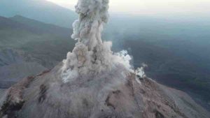
Due to the difficult accessibility and the high risk of collapse or explosion, the imaging of active volcanoes has so far been a great challenge in volcanology. Researchers around Edgar Zorn from the German Research Centre for Geosciences GFZ in Potsdam are now presenting the results of a series of repeated survey flights with optical and thermal imaging cameras at the Santa Maria volcano in Guatemala. Drones were used to observe the lava dome, a viscous plug of lava. The researchers were able to show that the lava dome shows movements on two different time scales: slow expansion and growth of the dome and fast extrusion of viscous lava. The study was published in the journal “Scientific Reports.”
“We have equipped a drone with different cameras,” says Edgar Zorn from GFZ, the first author of the study. “We then flew the drone over the crater at various intervals, measuring the movements of lava flow and a lava dome using a specific type of stereo photography with a precision never seen before.” By comparing the data from the drone, we were able to determine the flow velocity, movement patterns and surface temperature of the volcano. These parameters are important for predicting the danger of explosive volcanoes. The researchers also succeeded in deriving the flow properties of the lava from these data.
“We have shown that the use of drones can help to completely re-measure even the most dangerous and active volcanoes on Earth from a safe distance,” continues Edgar Zorn. “A regular and systematic survey of dangerous volcanoes with drones seems to be almost within one’s grasp,” says Thomas Walter, volcanologist at GFZ, who was also involved in the study.
The two cameras of the drone used on the Caliente volcanic cone of the Santa Maria volcano were able to take high-resolution photos on the one hand and thermal imaging on the other. Using a special computer algorithm, the researchers were able to create complete and detailed 3D models from these images. They obtained a 3D topography and temperature model of the volcano with a resolution of only a few centimetres.
Drone missions considerably reduce the risk for volcanologists, as the cameras can be flown directly to the dangerous spots without the scientists having to go near them themselves. Instead, the greatest challenge lies in the post-processing and calculation of the models. “The 3D models of the various flights must be positioned exactly so that they can be compared. This requires painstaking detail work, but the effort is worth it because even minimal movements become immediately visible,” says Edgar Zorn. “In the study, we presented some new possibilities for the representation and measurement of certain ground movements, which could be very useful in future projects.”
Reference:
Edgar U. Zorn, Thomas R. Walter, Jeffrey B. Johnson, René Mania. UAS-based tracking of the Santiaguito Lava Dome, Guatemala. Scientific Reports, 2020; 10 (1) DOI: 10.1038/s41598-020-65386-2
An artistic life reconstruction of Nannopterygius. Credit: Andrey Atuchin
A Russian paleontologist visiting the Natural History Museum in London desperately wanted a good look at the skeleton of an extinct aquatic reptile, but its glass case was too far up the wall. So he attached his digital camera to a fishing rod and — with several clicks — snagged a big one, scientifically speaking.
Images from the “selfie stick” revealed that the creature, whose bones were unearthed more than a century ago on a coast in southern England, seemed very similar to a genus of ichthyosaurs he recognized from Russian collections.
He emailed the photos of the dolphin-like ichthyosaur to fellow paleontologist Megan L. Jacobs, a Baylor University doctoral candidate in geosciences. She quickly realized that the animal’s skeletal structure matched not only some ichthyosaurs she was studying in a fossil museum on the English Channel coast, but also some elsewhere in the United Kingdom.
Jacobs and paleontologist Nikolay G. Zverkov of the Russian Academy of Sciences — who “fished” for the ichthyosaur — merged their research, studying their collective photos and other materials and ultimately determining that the Russian and English ichthyosaurs were of the same genus and far more common and widespread than scientists believed.
Their study is published in the Zoological Journal of the Linnean Society.
“Ichthyosaurs swam the seas of our planet for about 76 million years,” Jacobs said. “But this 5-foot ichthyosaur from some 150 million years ago was the least known and believed to be among the rarest ichthyosaurs. The skeleton in the case, thought to be the only example of the genus, has been on display in the Natural History Museum in London since 1922.
“Nikolay’s excellent detailed photos significantly expand knowledge of Nannopterygius enthekiodon,” she said. “Now, after finding examples from museum collections across the United Kingdom, Russia and the Arctic — as well as several other Nannopterygius species — we can say Nannopterygius is one of the most widespread genera of ichthyosaurs in the Northern Hemisphere.”
Additionally, the study described a new species, Nannopterygius borealis, dating from about 145 million years ago in a Russian archipelago in the Arctic. The new species is the northernmost and youngest representative of its kind, Jacobs said.
Previously, for the Middle and Late Jurassic epochs, the only abundant and most commonly found ichthyosaur was Ophthalmosaurus, which had huge eyes and was about 20 feet long. It was known from hundreds of specimens, including well-preserved skeletons from the Middle Jurassic Oxford Clay Formation of England, Jacobs said.
“For decades, the scientific community thought that Nannopterygius was the rarest and most poorly known ichthyosaur of England,” Zverkov said. “Finally, we can say that we know nearly every skeletal detail of these small ichthyosaurs and that these animals were widespread. The answer was very close; what was needed was just a fishing rod.”
Reference:
Nikolay G Zverkov; Megan L Jacobs. Revision of Nannopterygius (Ichthyosauria: Ophthalmosauridae): reappraisal of the ‘inaccessible’ holotype resolves a taxonomic tangle and reveals an obscure ophthalmosaurid lineage with a wide distribution. Zoological Journal of the Linnean Society, 2020 DOI: 10.1093/zoolinnean/zlaa028
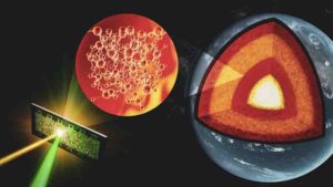
Researchers developed a technique that allows them to study the atomic arrangements of liquid silicates at the extreme conditions found in the core-mantle boundary. This could lead to a better understanding of the Earth’s early molten days, which could even extend to other rocky planets. Credit: Greg Stewart/SLAC National Accelerator Laboratory
Far below the Earth’s surface, about 1,800 miles deep, lies a roiling magmatic region sandwiched between the solid silicate-based mantle and molten iron-rich core: The core-mantle boundary. It’s a remnant of olden times, the primordial days about 4.5 billion years ago when the entire planet was molten, an endless sea of magma. Although the region’s extreme pressures and temperatures make it difficult to study, it contains clues about the mysterious origin story of the world as we know it.
“We’re still trying to piece together how the Earth actually started to form, how it transformed from a molten planet to one with living creatures walking around on its silicate mantle and crust,” says Arianna Gleason, a scientist at the Department of Energy’s SLAC National Accelerator Laboratory. “Learning about the strange ways materials behave under different pressures can give us some hints.”
Now, scientists have developed a way to study liquid silicates at the extreme conditions found in the core-mantle boundary. This could lead to a better understanding of the Earth’s early molten days, which could even extend to other rocky planets. The research was led by scientists Guillaume Morard and Alessandra Ravasio. The team, which included Gleason and other researchers from SLAC and Stanford University, published their findings this week in the Proceedings of the National Academy of Sciences.
“There are features of liquids and glasses, in particular silicate melts, that we don’t understand,” says Morard, a scientist at the University of Grenoble and Sorbonne University in France. “The problem is that molten materials are intrinsically more challenging to study. Through our experiments we were able to probe geophysical materials at the extremely high temperatures and pressures of deep Earth to tackle their liquid structure and learn how they behave. In the future we will be able to use these types of experiments to recreate the first moments of Earth and understand the processes that shaped it.”
Hotter than the sun
At SLAC’s Linac Coherent Light Source (LCLS) X-ray free-electron laser, the researchers first sent a shockwave through a silicate sample with a carefully tuned optical laser. This allowed them to reach pressures that mimic those at the Earth’s mantle, 10 times higher than previously achieved with liquid silicates, and temperatures as high as 6,000 Kelvin, slightly hotter than the surface of the sun.
Next, the researchers hit the sample with ultrafast X-ray laser pulses from LCLS at the precise moment the shockwave reached the desired pressure and temperature. Some of the X-rays then scattered into a detector and formed a diffraction pattern. Just like every person has their own set of fingerprints, the atomic structure of materials is often unique. Diffraction patterns reveal that material fingerprint, allowing the researchers to follow how the sample’s atoms rearranged in response to the increase of pressure and temperature during the shockwave. They compared their results to those of previous experiments and molecular simulations to reveal a common evolutionary timeline of glasses and liquid silicates at high pressure.
“It’s exciting to be able to gather all these different techniques and get similar results,” says SLAC scientist and co-author Hae Ja Lee. “This allows us to find a combined framework that makes sense and take a step forward. It’s very comprehensive compared to other studies.”
Connecting the atomistic to the planetary
In the future, the LCLS-II upgrade, as well as upgrades to the Matter in Extreme Conditions (MEC) instrument where this research was performed, will allow scientists to recreate the extreme conditions found in the inner and outer core to learn about how iron behaves and the role it plays in generating and shaping Earth’s magnetic field.
To follow up on this study, the researchers plan to perform experiments at higher X-ray energies to make more precise measurements of the atomic arrangement of liquid silicates. They also hope to reach higher temperatures and pressures to gain insight into how these processes unfold in planets bigger than Earth, so-called super-Earths or exoplanets, and how the size and location of a planet influences its composition.
“This research allows us to connect the atomistic to the planetary,” Gleason says. “As of this month, more than 4,000 exoplanets have been discovered, about 55 of which are positioned in the habitable zone of their stars where it’s possible for liquid water to exist. Some of those have evolved to the point where we believe there’s a metallic core that could generate magnetic fields, which shield planets from stellar winds and cosmic radiation. There are so many pieces that need to fall into place for life to form and be sustained. Making the important measurements to better understand the construction of these planets is crucial in this age of discovery.”
Reference:
Guillaume Morard et al, In situ X-ray diffraction of silicate liquids and glasses under dynamic and static compression to megabar pressures, Proceedings of the National Academy of Sciences (2020). DOI: 10.1073/pnas.1920470117
An artist’s impression of what an elaphrosaur may have looked like. Credit: Ruairidh Duncan
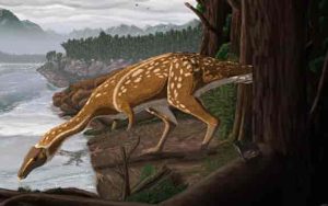
A chance discovery by a volunteer dinosaur digger has unearthed an unusual toothless dinosaur, known as an elaphrosaur, that roamed Australia 110 million years ago.
In early 2015, Dinosaur Dreaming volunteer Jessica Parker found a strange and delicate bone during the annual dig at the Cretaceous-aged fossil site known as Eric the Red West, near Cape Otway in Victoria.
The five centimetre long bone was identified at the Melbourne Museum as a vertebra. It was thought to be from a flying reptile called a pterosaur, albeit one quite different from the Ferrodraco lentoni, discovered in Queensland.
When Swinburne palaeontologists Dr. Stephen Poropat and Ph.D. candidate Adele Pentland attempted to work out what type of pterosaur it was, they hit a snag.
“Pterosaur neck vertebrae are very distinctive,” says Ms Pentland. “In all known pterosaurs, the body of the vertebra has a socket at the head end, and a ball or condyle at the body end. This vertebra had sockets at both ends, so it could not have been from a pterosaur.”
After extensive research Dr. Poropat and Ms Pentland reached a startling conclusion.
“We soon realised that the neck bone we were studying was from a theropod: a meat-eating dinosaur, related to Tyrannosaurus rex, Velociraptor, and modern birds,” says Dr. Poropat. “The only catch—this ‘meat-eating dinosaur’ probably didn’t eat meat!”
The new Victorian fossil is an excellent match for vertebrae from a strange group of theropods called elaphrosaurs or ‘light-footed lizards.”
And it’s a dinosaur out of time. Most of its known relatives—like Elaphrosaurus from Tanzania, and Limusaurus from China—lived near the end of the Jurassic Period, around 160–145 million years ago.
By contrast, the new Victorian elaphrosaur dates to almost 40 million years later, from the Early Cretaceous Period and is one of only two Cretaceous elaphrosaurs ever found. At around two metres long, it was also rather small for an elaphrosaur.
“Elaphrosaurs had long necks, stumpy arms with small hands, and relatively lightly built bodies,” Dr. Poropat says.
“As dinosaurs go, they were rather bizarre. The few known skulls of elaphrosaurs show that the youngsters had teeth, but that the adults lost their teeth and replaced them with a horny beak. We don’t know if this is true for the Victorian elaphrosaur yet—but we might find out if we ever discover a skull.”
The dinosaur graveyard at the Eric the Red West site awaits further exploration. Proposed digs this year have been postponed twice because of the bushfire season and the COVID-19 pandemic.
Palaeontologists hope to be able to return safely to Cape Otway to unearth more fossils soon.
The paper describing the new Victorian elaphrosaur is published in Gondwana Research.
Reference:
Stephen F. Poropat et al. First elaphrosaurine theropod dinosaur (Ceratosauria: Noasauridae) from Australia—A cervical vertebra from the Early Cretaceous of Victoria, Gondwana Research (2020). DOI: 10.1016/j.gr.2020.03.009
Robert Reisz examined fossils from the embryos of Lufengosaurus, an early sauropodomorph species that predates more recognizable sauropods. Credit: David Mazierski
In the age of giant reptiles, sauropods were the biggest of all. Long-tailed, long-necked species like Diplodocus and Apatosaurus were the largest dinosaurs. From tip to tail, some sauropods were up to 40 metres long.
These giant herbivores ranged across the globe and thrived throughout the age of dinosaurs, nearly 150 million years.
“Sauropods are the one group that was successful from the beginning of the age of dinosaurs until the very end,” says Robert Reisz, a paleontologist and professor of biology at U of T Mississauga.
Despite their enormous size, sauropods had relatively small heads and mouths. They fed by ripping plant material from trees and bushes, and would have needed to eat almost constantly.
But sauropods did not have the extensive chewing capabilities of the large headed duckbill dinosaurs which are well known for their massive dental batteries. Instead, sauropods like titanosaurs and diplodocids evolved a different strategy for dealing with harsh, hard to process plant materials, using simplified, small, pencil shaped, rapidly growing new teeth that were worn down and replaced very quickly.
In research published in Nature Communications, Reisz examined fossils from the embryos of Lufengosaurus, an early sauropodomorph species that predates more recognizable sauropods like titanosaurs and diplodocids, which came later. Found in China’s Yunnan province, the fossils provided a record of Lufengosaurus at different stages of development, and showed distinct phases of tooth development.
In one of these phases, Lufengosaurus embryos had pencil-like teeth that resemble those found in some adult diplodocid and titanosaur sauropods. The finding suggests that the similar tooth structures that emerged in later sauropod species evolved through the retention of features present in the early stages of development of their distant predecessors.
“This evolutionary phenomenon, called paedomorphosis, is more frequently associated with small animals, but in this case, we seem to see it in big animals too,” Reisz says.
While Reisz’ sauropod research relied on rare embryo fossils, his examination of an even more ancient reptile relied upon a relative abundance of specimens.
Captorhinus aguti is a reptile that lived in the Permian Period (289 million years ago), well before the age of dinosaurs. In research published in Current Biology, Reisz studied 95 Captorhinus fossils to identify whether these four-legged reptiles displayed traits associated with brain lateralization—the asymmetrical brain function that can be observed in humans, birds, mammals and reptiles.
“The best-known lateralization is human right-handedness, and we know that right-handed people also prefer to eat on the right side,” says Reisz.
This project came about because Diane Scott, research assistant to Reisz, noticed that in one nearly perfect skull of this reptile one side of the dentition was more worn than the other side. Reisz’s team used the large number of lower jaws of this reptile, all from a single site, in order to understand it’s population-level chewing preferences.
“When you only have one specimen, it doesn’t really tell you a story,” says Reisz. “Maybe there was something wrong with that individual—a muscle anomaly that caused it to happen. But here, we have a population-level examination, all from a single pocket.”
The right jaws of Captorhinus showed more wear than the left, suggesting that even 289 million years ago, reptiles were displaying traits associated with brain asymmetry.
“It’s circumstantial evidence, but we think this indicates a subdivision of the brain, and suggests that functional brain asymmetry is a deeply nested phenomenon in vertebrate evolution, and this is the first time that we’ve seen it in fossils.”
Reference:
Robert R. Reisz et al. Early Jurassic dinosaur fetal dental development and its significance for the evolution of sauropod dentition, Nature Communications (2020). DOI: 10.1038/s41467-020-16045-7
Robert R. Reisz et al. Lateralized Feeding Behavior in a Paleozoic Reptile, Current Biology (2020). DOI: 10.1016/j.cub.2020.04.026
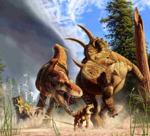
In this artist’s depiction of wildlife from Alberta, Canada, 77 million years ago, the tyrannosaur Daspletosaurus hunts a young horned Spinops, while an adult Spinops tries to interfere and a Coronosaurus watches from a distance. Credit: Julius Csotonyi.
Long legs may make good runners, but they’re great for walking, too. Scientists have generally assumed that long-limbed dinosaurs evolved their leggy proportions for speed to catch prey and avoid predators.
But a new study by the University of Maryland’s Thomas Holtz and his colleagues suggests that long legs evolved among the biggest dinosaurs to help them conserve energy and go the distance as they ambled along searching for prey. The study was published in the journal PLOS ONE on May 13, 2020.
“The assumption tends to be that animals with adaptations for running, such as long legs, are adapted for a higher maximum speed, but this paper shows that there’s more to running than top speed,” said Thomas Holtz, principal lecturer in the UMD Department of Geology. “When you’re a bigger animal, those adaptations may also be for endurance and efficiency. It may be about being a marathoner rather than a sprinter.”
Holtz and his colleagues analyzed a variety of metrics like limb proportions, size ratio, body mass and gaits to estimate the top speeds of more than 70 species from a group of dinosaurs called theropods. Theropods ranged in size from less than a half-pound to more than nine tons. They included Tyrannosaurus rex and the many other two-legged predators that dominated the age of dinosaurs for 180 million years. Bipedalism and running speed have often been cited as major contributors to their success.
The study revealed a more nuanced story. According to the new analysis, longer legs were associated with higher top speeds in small and medium-sized dinosaurs, but that didn’t hold true for dinosaurs weighing over 2,200 pounds. Scientists have known that larger body size can limit speed, and the study showed that large dinosaur species with longer legs were no faster than their stubby-limbed brethren. But they moved more efficiently.
By calculating how much energy each dinosaur expended while moving at walking speeds, the researchers found that among the largest dinosaurs, those with longer legs needed less energy to cruise around.
“That’s actually a very beneficial savings, because predators tend to spend a great deal of their time foraging, searching for prey,” Holtz said. “If you are burning less fuel during the foraging part of the day, that’s an energy savings that dinosaurs with shorter leg forms didn’t get.”
These results highlight the often-overlooked impact of body proportions on running ability and the limiting effect of large body size on running speed. Clearly, there are different kinds of runners. This work should broaden the discussion about what it means to be adapted for running.
The research paper, “The fast and the frugal: Divergent locomotory strategies drive limb lengthening in theropod dinosaurs,” T. Alexander Dececchi, Aleksandra M. Mloszewska, Thomas R. Holtz Jr., Michael B. Habib, Hans C.E. Larsson, was published in the journal PLOS ONE on May 13, 2020.
Reference:
Dececchi TA, Mloszewska AM, Holtz TR Jr, Habib MB, Larsson HCE (2020) The fast and the frugal: Divergent locomotory strategies drive limb lengthening in theropod dinosaurs. PLoS ONE 15(5): e0223698. doi.org/10.1371/journal.pone.0223698
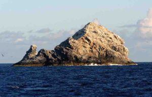
The only remnants of Pūhāhonu that are above sea level (Gardner Pinnacles). Credit: NOAA
In a recently published study, researchers from the University of Hawai’i at Mānoa School of Ocean and Earth Science and Technology revealed the largest and hottest shield volcano on Earth. A team of volcanologists and ocean explorers used several lines of evidence to determine Pūhāhonu, a volcano within the Papahānaumokuākea Marine National Monument now holds this distinction.
Geoscientists and the public have long thought Mauna Loa, a culturally-significant and active shield volcano on the Big Island of Hawai’i, was the largest volcano in the world. However, after surveying the ocean floor along the mostly submarine Hawaiian leeward volcano chain, chemically analyzing rocks in the UH Mānoa rock collection, and modeling the results of these studies, the research team came to a new conclusion. Pūhāhonu, meaning ‘turtle rising for breath’ in Hawaiian, is nearly twice as big as Mauna Loa.
“It has been proposed that hotspots that produce volcano chains like Hawai’i undergo progressive cooling over 1-2 million years and then die,” said Michael Garcia, lead author of the study and retired professor of Earth Sciences at SOEST. “However, we have learned from this study that hotspots can undergo pulses of melt production. A small pulse created the Midway cluster of now extinct volcanoes and another, much bigger one created Pūhāhonu. This will rewrite the textbooks on how mantle plumes work.”
In 1974, Pūhāhonu (then called Gardner Pinnacles) was suspected as the largest Hawaiian volcano based on very limited survey data. Subsequent studies of the Hawaiian Islands concluded that Mauna Loa was the largest volcano but they included the base of the volcano that is below sea level that was not considered in the 1974 study. The new comprehensive surveying and modeling, using methods similar to those used for Mauna Loa show that Pūhāhonu is the largest.
This study highlights Hawaiian volcanoes, not only now but for millions of years, have been erupting some of the hottest magma on Earth. This work also draws attention to an infrequently visited part of the state of Hawai’i that has ecological, historical and cultural importance.
“We are sharing with the science community and the public that we should be calling this volcano by the name the Hawaiians have given to it, rather than the western name for the two rocky small islands that are the only above sea level remnants of this once majestic volcano,” said Garcia.
Reference:
Michael O. Garcia et al, Pūhāhonu: Earth’s biggest and hottest shield volcano, Earth and Planetary Science Letters (2020). DOI: 10.1016/j.epsl.2020.116296
Three earthquakes in the Monterey Bay Area, occurring in 1838, 1890 and 1906, happened without a doubt on the San Andreas Fault, according to a new paper by a Portland State University researcher.
The paper, “New Insights into Paleoseismic Age Models on the Northern San Andreas Fault: Charcoal In-built ages and Updated Earthquake Correlations,” was recently published in the Bulletin of the Seismological Society of America.
Assistant Professor of Geology at PSU Ashley Streig said the new research confirms what her team first discovered in 2014: three earthquakes occurred within a 68-year period in the Bay Area on the San Andreas Fault.
“This is the first time there’s been geologic evidence of a surface rupture from the historic 1838 and 1890 earthquakes that we knew about from newspapers and other historical documents,” Streig said. “It basically meant that the 1800s were a century of doom.”
Building on the 2014 study, Streig said they were able to excavate a redwood slab from a tree felled by early Europeans, from one meter below the surface in the Bay Area. The tree was toppled before the three earthquakes in question occurred. That slab was used to determine the precise date logging first occurred in the area, and pinpointed the historic dates of the earthquakes. Further, they were able use the slab to develop a new model for determining recurrence intervals and more exact dating.
Streig used the dating technique wiggle matching for several measured carbon 14 samples from the tree slab and compared them with fluctuations in atmospheric carbon 14 concentrations over time to fingerprint the exact death of the tree and confirm the timing of the earthquakes. Because the researchers had an exact age from the slab, they were able to test how well the most commonly used material, charcoal, works in earthquake age models.
Charcoal is commonly used for dating and to constrain the ages of prehistoric earthquakes and develop an earthquake recurrence interval, but Streig said the charcoal can be hundreds of years older than the stratigraphic layer containing it, yielding an offset between what has been dated and the actual age of the earthquake. The new technique accounts for inbuilt charcoal ages — which account for the difference in time between the wood’s formation and the fire that generated said charcoal — and can better estimate the age of the event being studied.
“We were able to evaluate the inbuilt age of the charcoal incorporated in the deposits and find that charcoal ages are approximately 322 years older than the actual age of the deposit — so previous earthquake age models in this area using detrital charcoal would be offset roughly by this amount,” she said.
New earthquake age modeling using a method to correct for this charcoal inbuilt age, and age results from the tree stump are what give Streig absolute certainly that the 1838 and 1890 earthquakes in question occurred on the San Andreas Fault and during those years.
“We put the nail in the coffin,” she added.
Reference:
Ashley R. Streig; Ray J. Weldon, II; Glenn Biasi; Timothy E. Dawson; Daniel G. Gavin; Tom P. Guilderson. New Insights into Paleoseismic Age Models on the Northern San Andreas Fault: Charcoal Inbuilt Ages and Updated Earthquake Correlations. Bulletin of the Seismological Society of America, 2020 DOI: 10.1785/0120190307
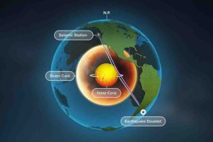
A new study of Earth’s inner core used seismic data from repeating earthquakes, called doublets, to find that refracted waves, blue, rather than reflected waves, purple, change over time — providing the best evidence yet that Earth’s inner core is rotating. Credit: Michael Vincent
Exhaustive seismic data from repeating earthquakes and new data-processing methods have yielded the best evidence yet that the Earth’s inner core is rotating — revealing a better understanding of the hotly debated processes that control the planet’s magnetic field.
The new study by researchers from the University of Illinois at Urbana-Champaign is published in the journal Earth and Planetary Science Letters.
Geologists do not fully understand how the Earth’s magnetic field generator works, but suspect it is closely linked to dynamic processes near the inner core-outer core boundary area, the researchers said. Shifts in the location of the magnetic poles, changes in field strength and anomalous seismic data have prompted researchers to take a closer look.
“In 1996, a small but systematic change of seismic waves passing through the inner core was first detected by our group, which we interpreted as evidence for differential rotation of the inner core relative to the Earth’s surface,” said geology professor and study co-author Xiaodong Song, who is now at Peking University. “However, some studies believe that what we interpret as movement is instead the result of seismic waves reflecting off an alternately enlarging and shrinking inner core boundary, like growing mountains and cutting canyons.”
The researchers present seismic data from a range of geographic locations and repeating earthquakes, called doublets, that occur in the same spot over time. “Having data from the same location but different times allows us to differentiate between seismic signals that change due to localized variation in relief from those that change due to movement and rotation,” said Yi Yang, a graduate student and lead author of the study.
The team found that some of the earthquake-generated seismic waves penetrate through the iron body below the inner core boundary and change over time, which would not happen if the inner core were stationary, the researchers said. “Importantly, we are seeing that these refracted waves change before the reflected waves bounce off the inner core boundary, implying that the changes are coming from inside the inner core,” Song said.
The basis of the debate lies in the fact the prior studies looked at a relatively small pool of somewhat ambiguous data generated from a method that is highly dependent on accurate clock time, the researchers said.
“What makes our analysis different is our precise method for determining exactly when the changes in seismic signals occur and arrive at the various seismic stations across the globe,” Yang said. “We use a seismic wave that did not reach inner core as a reference wave in our calculations, which eliminates a lot of the ambiguity.”
This precise arrival time analysis, an extensive collection of the best quality data and careful statistical analysis performed by Yang, are what give this study its power, Song said. “This work confirms that the temporal changes come mostly, if not all, from the body of the inner core, and the idea that inner core surface changes are the sole source of the signal changes can now be ruled out,” he said.
Reference:
Yi Yang, Xiaodong Song. Origin of temporal changes of inner-core seismic waves. Earth and Planetary Science Letters, 2020; 541: 116267 DOI: 10.1016/j.epsl.2020.116267
Scientists from The University of Western Australian and University of Cambridge have made a chance discovery in UK museum collections, finding hollow ball-like structures in 80-million-year-old fossils from species believed to be related to starfish and sea urchins.
The scientists found the unusual structures known as buckyballs made up of a series of hexagons and pentagons in two species—the Uintacrinus socialis and Marsupites testudinarius. They believe the structures might have acted as a buoyancy chamber to allow the crinoid organisms to float in seawater, but also protect them.
UWA Adjunct Research Fellow Aaron Hunter from UWA’s School of Earth Sciences said crinoids were in a very dangerous place millions of years ago when the oceans were shallower and they shared them with predators such as crabs and fish.
“Survival was critical and the ball-like structures, able to withstand very heavy loads, formed around them to protect them from the harms of the ocean and aid buoyancy,” Dr. Hunter said.
“These animals could then spread around the world and have been found in chalk rocks from Texas, US to Kalbarri in Western Australia. They could form a snow shoe to sit on the bottom of the shallow oceans or float and relocate to safer places.”
Dr. Hunter said in comparing the two species, Marsupites testudinarius had fewer but relatively large plates, creating a stable structure.
“Uintacrinus socialis on the other hand has far more complex plates that form a dome,” he said.
“The structures are also found in the carbon molecule Buckminsterfullerene but this is the first time we have found such a structure in fossils and it still remains a mystery why these successful structures did not evolve again.”
“Later, architect Buckminster Fuller would rediscover and popularise these structures and apply them to creating iconic buildings such as the Eden project in Cornwall in UK. However most would recognise the structure in the humble soccer ball we know and love.”
This two-billion-year-old shungite records evidence for balmy, oxygen-rich conditions on the early Earth. Credit: K. Paiste.
Earth may have been far more oxygen-rich early in its history than previously thought, setting the stage for the evolution of complex life, according to new research by scientists at the University of Alberta and the University of Tartu in Estonia. The study provides evidence for elevated oxygen levels 2 billion years ago and flies in the face of previously accepted models.
The international team of researchers, led by UAlberta scientists, studied a Russian drill core containing shungite — a unique carbon-rich sedimentary rock deposited 2 billion years ago. The material provides several clues about oxygen concentrations on Earth’s surface at that time, including strikingly high levels of molybdenum, uranium, and rhenium, as well as elevated uranium isotope ratios.
“These trace metals are only thought to be common in Earth’s oceans and sediments when oxygen is abundant,” explained Kaarel Mänd, a PhD candidate in the University of Alberta’s Department of Earth and Atmospheric Sciences and lead author of the study. “These trace metal concentrations are unrivaled in early Earth’s history, suggesting elevated levels of oxygen at the time when the shungite was deposited.”
What’s puzzling, Mänd explained, is that many widely accepted models of Earth’s carbon and oxygen cycles predict that shungite should have been deposited at a time of rapid decrease in oxygen levels.
“What we found contradicts the prevailing view,” says Mänd, who is completing his PhD under the supervision of Professor Kurt Konhauser. “This will force the Earth science community to rethink what drove the carbon and oxygen cycles on the early Earth.”
The new findings also provide insight into the evolution of complex life. Earth’s “middle age” represents the backdrop for the appearance of eukaryotes. Eukaryotes are the precursors to all complex life, and require high oxygen levels in their environment to thrive. This study strengthens the idea that suitable conditions for the evolution of complex life on early Earth began much earlier than previously thought.
Future research will examine the delay between the initial rise of oxygen and the appearance and spread of eukaryotes, remaining an area of active research, one that University of Alberta and University of Tartu researchers are well positioned to help answer.
Reference:
Kaarel Mänd, Stefan V. Lalonde, Leslie J. Robbins, Marie Thoby, Kärt Paiste, Timmu Kreitsmann, Päärn Paiste, Christopher T. Reinhard, Alexandr E. Romashkin, Noah J. Planavsky, Kalle Kirsimäe, Aivo Lepland, Kurt O. Konhauser. Palaeoproterozoic oxygenated oceans following the Lomagundi–Jatuli Event. Nature Geoscience, 2020; 13 (4): 302 DOI: 10.1038/s41561-020-0558-5
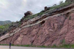
Francis Macdonald walks along a road near Manitou Springs, Colorado, where an exposed outcrop shows a feature known as the “Great Unconformity.” Photo Credit: Rebecca Flowers
The geologic record is exactly that: a record. The strata of rock tell scientists about past environments, much like pages in an encyclopedia. Except this reference book has more pages missing than it has remaining. So geologists are tasked not only with understanding what is there, but also with figuring out what’s not, and where it went.
One omission in particular has puzzled scientists for well over a century. First noticed by John Wesley Powell in 1869 in the layers of the Grand Canyon, the Great Unconformity, as it’s known, accounts for more than one billion years of missing rock in certain places.
Scientists have developed several hypotheses to explain how, and when, this staggering amount of material may have been eroded. Now, UC Santa Barbara geologist Francis Macdonald and his colleagues at the University of Colorado, Boulder and at Colorado College believe they may have ruled out one of the more popular of these. Their study appears in the Proceedings of the National Academy of Sciences.
“There are unconformities all through the rock record,” explained Macdonald, a professor in the Department of Earth Science. “Unconformities are just gaps in time within the rock record. This one’s called the Great Unconformity because it was thought to be a particularly large gap, maybe a global gap.”
A leading thought is that glaciers scoured away kilometers of rock around 720 to 635 million years ago, during a time known as Snowball Earth, when the planet was completely covered by ice. This hypothesis even has the benefit of helping to explain the rapid emergence of complex organisms shortly thereafter, in the Cambrian explosion, since all this eroded material could have seeded the oceans with tremendous amounts of nutrients.
Macdonald was skeptical of this reasoning. Although analogues of the Great Unconformity appear throughout the world — with similar amounts of rock missing from similar stretches of time — they don’t line up perfectly. This casts doubt as to whether they were truly eroded by a global event like Snowball Earth.
Part of the challenge of investigating the Great Unconformity is that it happened so long ago, and the Earth is a messy system. “These rocks have been buried and eroded multiple times through their history,” Macdonald said.
Fortunately, the team was able to test this hypothesis using a technique called thermochronology. A few kilometers below the Earth’s surface, the temperature begins to rise as you get closer to the planet’s hot mantle. This creates a temperature gradient of roughly 50 degrees Celsius for every kilometer of depth. And this temperature regime can become imprinted in certain minerals.
As certain radioactive elements in rocks break down, Helium-4 is produced. In fact helium is constantly being generated, but the fraction retained in different minerals is a function of temperature. As a result, scientists can use the ratio of helium to thorium and uranium in certain minerals as a paleo-thermometer. This phenomenon enabled Macdonald and his coauthors to track how rock moved in the crust as it was buried and eroded through the ages.
“These unconformities are forming again and again through tectonic processes,” Macdonald said. “What’s really new is we can now access this much older history.”
The team took samples from granite just below the boundary of the Great Unconformity at Pikes Peak in Colorado. They extracted grains of a particularly resilient mineral, zircon, from the stone and analyzed the radio nucleotides of helium contained inside. The technique revealed that several kilometers of rock had been eroded from above this granite between 1,000 and 720 million years ago.
Importantly, this stretch of time definitively came before the Snowball Earth episodes. In fact, it lines up much better with the periods in which the supercontinent Rodinia was forming and breaking apart. This offers a clue to the processes that may have stricken these years from the geologic record.
“The basic hypothesis is that this large-scale erosion was driven by the formation and separation of supercontinents,” Macdonald said.
The Earth’s cycle of supercontinent formation and separation uplifts and erodes incredible extents of rock over long periods of time. And because supercontinent processes, by definition, involve a lot of land, their effects can appear fairly synchronous across the geologic record.
However, these processes don’t happen simultaneously, as they would in a global event like Snowball Earth. “It’s a messy process,” Macdonald said. “There are differences, and now we have the ability to perhaps resolve those differences and pull that record out.”
While Macdonald’s results are consistent with a tectonic origin for these great unconformities, they don’t end the debate. Geologists will need to complement this work with similar studies in other regions of the world in order to better constrain these events.
The mystery of the Great Unconformity is inherently tied to two of geology’s other great enigmas: the rise and fall of Snowball Earth and the sudden emergence of complex life in the Ediacaran and Cambrian. Progress in any one could help researchers finally crack the lot.
“The Cambrian explosion was Darwin’s dilemma,” Macdonald remarked. “This is a 200-year old question. If we can solve that, we would definitely be rock stars.”
Reference:
Rebecca M. Flowers, Francis A. Macdonald, Christine S. Siddoway, Rachel Havranek. Diachronous development of Great Unconformities before Neoproterozoic Snowball Earth. Proceedings of the National Academy of Sciences, 2020; 201913131 DOI: 10.1073/pnas.1913131117
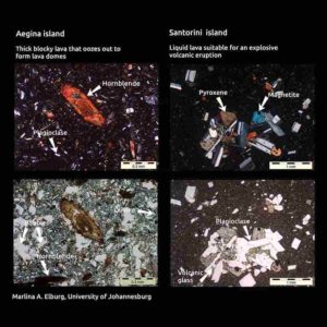
Why a big volcanic blow-up at the popular travel destimation Santorini 3200 years ago, but just a few hundred kilometers away, no drama at the volcanoes on Aegina , Methana and Poros islands? Thin sections of the lavas from these four volcanoes yield some of the reasons why. Some minerals only form at greater depths – and the hornblende in the lava from Aegina island indicates that the magma chambers there are deeper than the those underneath the Santorini caldera. But plate tectonics add another, hidden reason also, found research from the University of Johannesburg. Credit: Prof Marlina A. Elburg, University of Johannesburg
At an idyllic island in the Mediterranean Sea, ocean covers up the site of a vast volcanic explosion from 3200 years ago. A few hundred kilometers north-west, three other islands still have their volcanic histories from a few million years ago mostly intact. No explosions there. So why the differences between the Santorini caldera and the Aegina, Methana and Poros lava domes? Researchers used volcanic “fingerprints’ and plate tectonics research to find out why.
The end of a civilisation
A big volcano blew up about 3200 years ago, right next to where Santorini island is in Greece today. During that eruption, liquid molten rock under the ground (magma) built up immense pressure, and then erupted into a lava explosion. The impact was so intense that the volcano collapsed into a huge basin called a caldera.
What had been an island-volcano, was then overrun by ocean, an event considered partially responsible for the demise of the Minoan civilisation.
Santorini Island became a popular travel destination with big ocean-going ships sailing over the caldera. The village of Phira perches on the cliff-edge of the remains of the volcano.
As idyllic as it looks, the Santorini volcano underneath the ocean still constitutes the biggest volcanic hazard for Europe, together with the Vesuvius volcano in Italy.
Toothpaste rather than fireworks
A few hundred kilometers north-west of Santorini, in Greece’s Saronic Gulf, much closer to Athens, a completely different kind of “volcano” looks much less dramatic.
The small islands of Aegina, Methana and Poros sport rounded hills with roads winding uphill in hairpin bends. These hills have volcanic ancestry too—but they are nothing like Santorini.
Here, liquid lava didn’t explode in a big eruption.
“There is no evidence that that large dramatic events ever took place at these islands,” says Prof Marlina A. Elburg, a Geology researcher at the University of Johannesburg.
“Thick blocky lava oozed out of magma chambers under the ground at these islands between 5.3 to 2.6 million years ago, during the Pliocene. The lava was so thick, it was more like toothpaste or putty than liquid. It formed lava domes rather than lava volcanoes.
“After a few million years’ worth of weathering, they’re well camouflaged hills, but they are still considered volcanically active,” she says.
How is it possible that volcanoes so close in geological time and space can behave to differently? The researchers used several techniques to find out.
Finding volcanic ‘fingerprints’
Elburg and co-author Ingrid Smet, a Ph.D. candidate at the time, analysed samples of the lavas in new whole rock analyses, in research published in Lithos.
The study followed on their previous research on the lavas at Methana, also published in Lithos.
They looked for the ratios of very specific elements in the samples, called isotope signatures. Isotope signatures work similar to ‘fingerprints’ for lavas—they help researchers figure out what the lavas were made of, where, and when they were formed.
“Mostly the isotope signatures matched what one would expect from where the islands are located in the Aegean volcanic arc,” says Elburg.
But there were surprises too.
Subterranean recycling machine
Underneath all these volcanoes at Aegina, Methana, Poros and Santorini, something else is going on in deep inside the crust of planet Earth. Running roughly east to west underneath the Mediterranean Sea is the Aegean volcanic arc. This arc is where the African tectonic plate ‘dives under’ the Aegean microplate.
The ‘diving under’ process is called subduction by geologists. It means that one part of the cool outer crust of Earth starts moving underneath another part of the crust, getting ‘recycled’ inside the hot liquid rock of the Earth’s mantle.
The islands of Aegina, Methana, Poros and Santorini are not just islands with volcanoes. All of them are an integral part of Earth’s ‘recycling machine’ that keeps renewing the crust underneath the planet’s oceans.
This raises the question: Why do these islands have such different ‘lava histories’, even though all of them are on the edge of the Aegean plate?
Some of the answers have to do with what goes into the lava “mixes” for the volcanoes.
Variable lava mix recipes
The African plate ‘dives under’ the Aegean plate in an oceanic trench in the Mediterranean Sea. This happens very slowly at a few centimeters per year. Which means the pristine cold basalt of the down-going African plate’s crust has been soaking in ocean water for millions of years before it enters the much warmer magma underneath the over-riding Aegean plate.
“The crust of the down-going plate now consists of altered rocks, containing minerals with water in them. These minerals become unstable during subduction because of the increasing pressure and temperature, and release their water,” says Elburg.
“This water lowers the melting point of the mantle, similar to what happens when adding salt to ice. That is why the mantle under the over-riding starts to melt. It is this molten material, or magma, that flows/oozes out of volcanoes/lava domes as lava.”
Another possible ingredient of the differing lavas is sediments in the oceanic trench at the subduction zone. At the Aegean Arc the down-going plate is covered by a very thick pile of ocean sediments. Some of the sediment is former continental crust.
A lot of this sediment is ‘scraped off’ when the plate subducts and forms an accretionary (or build-up) wedge. However, some of it is also going down into the mantle and getting mixed with the melting mantle wedge, she says.
Same plate, different lavas
Since Aegina, Methana, Poros and Santorini volcanoes are all part of the same subduction zone, the different volcanic activity raises several big questions. One of these is:
Why the thick blocky lava at the western volcanic centres Aegina, Methana and Poros 2.5 to 2 million years ago, but liquid lava at Santorini 3,200 years ago?
The answers to this creates other questions about the recycling behaviour of the planet we live on.
But subduction zones are tricky to study. It’s not possible to go to one of those and come back with some sample materials. Scientists still need more understanding of what role the overriding plate plays; how much interaction there is between ascending magmas and the crust they ascend through; and whether subduction-related magmas obtain their geochemical signature from the sediment that is recycled back into the earth, says Elburg.
“The answers to these questions can help us understand to what extent the melting processes that started at more than 100 kilometers deep in the mantle, continue when the magma is closer to the surface of the earth,” she says.
“This process of ‘crustal contamination’ is yet another ‘Earth recycling machine’, which may also influence the potential for ore deposits—like in the Andes, where major copper deposits are found, and where this ‘intracrustal recycling’ is thought to play an important role”.
Deeper vs shallower
One way of studying lavas is to put thin slices (called thin sections) under a microscope and identify the minerals. Because minerals need different conditions to form, their presence can say a lot about where and how magmas were mixed.
In this study the minerals indicated that Santorini lavas were more liquid because they formed at inside shallower magma chambers, while the western volcanic centre lavas were thicker and more blocky because they formed in deeper magma chambers.
“The thin sections of the Santorini lavas display pyroxenes and significant plagioclase. This indicates that the magma from which the crystals formed was located at shallow depths in the earth,” says Elburg.
And there is an invisible reason the magma was at shallower depths at Santorini.
“The tectonic plate above Santorini’s magma chambers is being pulled apart. In geology terms, it is under localised extension. And because the plate is being stretched out and Santorini is in the middle of it, Santorini happens to be at the thinnest part of the plate.
“With a magma chamber at a shallower depth, the roof will cave in when the chamber starts emptying itself during an eruption. This makes the eruption even worse and creates a caldera, as at Santorini,” she adds.
No explosions
In contrast, when they looked at the thin sections of the thick blocky lavas from Aegina and Methana, they found hornblende. The mineral was absent in the Santorini lavas.
Hornblende can only form if the magma is deep enough in the Earth. This indicates that the magma chambers on Aegina and Methana should be located deeper than on Santorini.
“With the magma chambers at greater depths for the western Aegina- Methana-Poros volcanoes, that makes for changes in the lava. There the magma chambers underneath the lava domes did not cave in. Additionally, the crystallization of the amphibole mineral group that includes hornblende, makes magma more viscous, or sticky. So it is more difficult for the magma to come to the surface in the first place.
Over-riding plate vs sediment
To figure out whether the over-riding plate or the ocean sediments were the bigger factor in creating thick blocky lavas, the researchers analysed specific ‘lava fingerprints’. These radiogenic isotope ratios gave them the best indication on which materials were mixed into the underground magmas for those lavas.
“We compared Santorini with Aegina-Poros-Methana lavas in terms of their geochemistry on 87Sr/86Sr, 143Nd/144Nd and 208Pb/204Pb. They were distinctly different. Then by combining the radiogenic isotope signature of the lavas with trace element ratios, we managed to pinpoint the down-going sediment as the biggest influence creating thick blocky lavas, not the overriding plate.
No one lava size
“We found that Aegina and Methana-Poros have their own individual volcanic histories, even though they’re part of the Aegean arc.
“This means that a simple one-size-fits-all explanation, based on crustal contamination history, for the difference in eruptive style compared to Santorini does not work.
“Modern subduction zones are not all alike. Even in one volcanic arc, more than one eruptive style points to differences in subduction processes,” concludes Elburg.
Reference:
Marlina A. Elburg et al, Geochemistry of lavas from Aegina and Poros (Aegean Arc, Greece): Distinguishing upper crustal contamination and source contamination in the Saronic Gulf area, Lithos (2020). DOI: 10.1016/j.lithos.2020.105416
Mud volcanoes are geological structures formed by the eruption of semi-liquid and gas-enriched mud breccia on the Earth’s surface or on the sea floor. The migration processes of geofluids around mud volcanoes could provide useful information about the mineralogical and geochemical characteristics of hydrocarbon-bleaching process and hydrocarbon migration pathways.
However, it remains unclear how organic-inorganic interactions take place in mud volcanic systems, particularly the alteration of surface processes induced by reducing geofluids in mud volcanic systems and the spatial variations in geochemical conditions along the main flowing route of erupting fluids.
Recently, scientists from the Northwest Institute of Eco-Environment and Resources of the Chinese Academy of Sciences performed a detailed field investigation and laboratory study to determine the mineral and chemical compositions as well as iron speciation of near surface rocks in the Baiyanggou mud volcano area.
They systematically collected a total of 11 rock samples along the main flow of geofluids running on the slope of the Baiyanggou mud volcanic system and analyzed for their mineralogical and chemical compositions as well as for iron species using X-ray diffraction, X-ray fluorescence spectrometry and Mossbauer spectroscopy, respectively.
Besides, they also used iron speciation in response to redox conditions for the first time as a tracer of geofluid processes in order to better understand the migration processes of geofluids.
The analytical results clearly indicated spatial variations for most geochemical parameters caused by redox fluctuation processes around the Baiyanggou mud volcanic system.
All these processes may provide useful information for a better understanding of hydrocarbon-rock interactions in the mud volcanic systems.
Moreover, the study results also indicated that the Iron speciation of the solid rocks in the seepage areas could be considered as a potential indicator for the migration of reducing geofluids including hydrocarbons located underground.
This study has been published in Applied Geochemistry in an article entitled “Mineralogical and geochemical characteristics of hydrocarbon-bleached rocks in Baiyanggou mud volcanoes, Xinjiang, NW China.”
Reference:
Wang Xu et al. Mineralogical and geochemical characteristics of hydrocarbon-bleached rocks in Baiyanggou mud volcanoes, Xinjiang, NW China, Applied Geochemistry (2020). DOI: 10.1016/j.apgeochem.2020.104572
A close-up image showing the damaged head and body of the Dorsetichthys bechei with the arms of the Clarkeiteuthis montefiorei clamped around it Credit: Malcolm Hart, Proceedings of the Geologists’ Association
Scientists have discovered the world’s oldest known example of a squid-like creature attacking its prey, in a fossil dating back almost 200 million years.
The fossil was found on the Jurassic coast of southern England in the 19th century and is currently housed within the collections of the British Geological Survey in Nottingham.
In a new analysis, researchers say it appears to show a creature—which they have identified as Clarkeiteuthis montefiorei—with a herring-like fish (Dorsetichthys bechei) in its jaws.
They say the position of the arms, alongside the body of the fish, suggests this is not a fortuitous quirk of fossilization but that it is recording an actual palaeobiological event.
They also believe it dates from the Sinemurian period (between 190 and 199 million years ago), which would predate any previously recorded similar sample by more than 10 million years.
The research was led by the University of Plymouth, in conjunction with the University of Kansas and Dorset-based company, The Forge Fossils.
It has been accepted for publication in Proceedings of the Geologists’ Association and will also be presented as part of Sharing Geoscience Online, a virtual alternative to the traditional General Assembly held annually by the European Geosciences Union (EGU).
Professor Malcolm Hart, Emeritus Professor in Plymouth and the study’s lead author, said: “Since the 19th century, the Blue Lias and Charmouth Mudstone formations of the Dorset coast have provided large numbers of important body fossils that inform our knowledge of coleoid palaeontology. In many of these mudstones, specimens of palaeobiological significance have been found, especially those with the arms and hooks with which the living animals caught their prey.
“This, however, is a most unusual if not extraordinary fossil as predation events are only very occasionally found in the geological record. It points to a particularly violent attack which ultimately appears to have caused the death, and subsequent preservation, of both animals.”
In their analysis, the researchers say the fossilised remains indicate a brutal incident in which the head bones of the fish were apparently crushed by its attacker.
They also suggest two potential hypotheses for how the two animals ultimately came to be preserved together for eternity.
Firstly, they suggest that the fish was too large for its attacker or became stuck in its jaws so that the pair—already dead—settled to the seafloor where they were preserved.
Alternatively, the Clarkeiteuthis took its prey to the seafloor in a display of ‘distraction sinking’ to avoid the possibility of being attacked by another predator. However, in doing so it entered waters low in oxygen and suffocated.