back to top
27.8 C
New York
Sunday, October 6, 2024
Home Blog Page 49

Huge dinosaurs evolved different cooling systems to combat heat stroke

Gigantic dinosaurs like the sauropod Diplodocus, which weighed over 15 tons and was longer than an 18-wheeler truck, would have had problems with potentially lethal overheating. Hot blood from the body core would have been pumped to the head, damaging the delicate brain. New research shows that in sauropods, evaporation of moisture in the nose and mouth would have cooled extensive networks of venous blood destined for the brain. Other large dinosaurs evolved different brain-cooling mechanisms, but all involving evaporative cooling of blood in different regions of the head. Credit: Life restoration by Michael Skrepnick. Courtesy of WitmerLab at Ohio University.

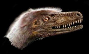
Different dinosaur groups independently evolved gigantic body sizes, but they all faced the same problems of overheating and damaging their brains. Researchers from Ohio University’s Heritage College of Osteopathic Medicine show in a new article in the Anatomical Record that different giant dinosaurs solved the problem in different ways, evolving different cooling systems in different parts of the head.

“The brain and sense organs like the eye are very sensitive to temperature,” said Ruger Porter, Assistant Professor of Anatomical Instruction and lead author of the study. “Animals today often have elaborate thermoregulatory strategies to protect these tissues by shuttling hot and cool blood around various networks of blood vessels. We wanted to see if dinosaurs were doing the same things.”

Many of the famous gigantic dinosaurs—such as the long-necked sauropods or armored ankylosaurs— actually evolved those big bodies independently from smaller-bodied ancestors. “Small dinosaurs could have just run into the shade to cool off,” said study co-author Professor Lawrence Witmer, “but for those giant dinosaurs, the potential for overheating was literally inescapable. They must have had special mechanisms to control brain temperature, but what were they?”

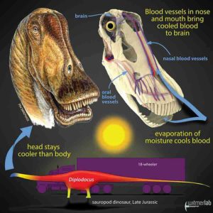
The answer turned out to be based in physics, but still part of our everyday experience. “One of the best ways to cool things down is with evaporation,” Porter said. “The air-conditioning units in buildings and cars use evaporation, and it’s the evaporative cooling of sweat that keeps us comfortable in summer. To cool the brain, we looked to the anatomical places where there’s moisture to allow evaporative cooling, such as the eyes and especially the nasal cavity and mouth.”

To test that idea, the team looked to the modern-day relatives of dinosaurs—birds and reptiles—where studies indeed showed that evaporation of moisture in the nose, mouth, and eyes cooled the blood on its way to the brain.

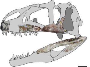
Porter and Witmer obtained carcasses of birds and reptiles that had died of natural causes from zoos and wildlife rehabilitation facilities. Using a technique developed in Witmer’s lab that allows arteries and veins to show up in CT scans, they were able to trace blood flow from the sites of evaporative cooling to the brain. They also precisely measured the bony canals and grooves that conveyed the blood vessels.

“The handy thing about blood vessels is that they basically write their presence into the bones,” Porter said. “The bony canals and grooves that we see in modern-day birds and reptiles are our link to the dinosaur fossils. We can use this bony evidence to restore the patterns of blood flow in extinct dinosaurs and hopefully get a glimpse into their thermal physiology and how they dealt with heat.”

“The discovery that different dinosaurs cooled their brains in a variety of ways not only provides a window into the everyday life of dinosaurs, it also serves as an exemplar of how the physical constraints imposed by specific environmental conditions have shaped the evolution of this diverse and unique group,” said Sharon Swartz, a program director at the National Science Foundation, which funded the research. “Using a combination of technological innovation and biological expertise, these researchers were able to take a direct reading from the fossil record that provides new clues about how dinosaur skeletal form and function evolved.”

This team of current and former members of WitmerLab at Ohio University has previously looked at other cases of dinosaur physiology. In 2014 and 2018, former doctoral student Jason Bourke led projects involving Porter and Witmer on breathing and heat exchange in pachycephalosaurs and ankylosaurs, respectively. Most recently, former lab doctoral student Casey Holliday led a project with Porter and Witmer that explored blood vessels on the skull roof of T. rex and other dinosaurs that also might have had a thermoregulatory function.

The new study by Porter and Witmer is a more expansive, quantitative study that shows that “one size didn’t fit all” with regard to how large-bodied dinosaurs kept their brains cool. That is, they had different thermoregulatory strategies. The researchers looked at bony canal sizes in the dinosaurs to assess the relative importance of the different sites of evaporative cooling based on how much blood was flowing through them.

A key factor turned out to be body size. Smaller dinosaurs such as the goat-sized pachycephalosaur Stegoceras had a very balanced vascular pattern with no single cooling region being particularly emphasized. “That makes physiological sense because smaller dinosaurs have less of a problem with overheating,” Porter said. “But giants like sauropods and ankylosaurs increased blood flow to particular cooling regions of the head far beyond what was necessary to simply nourish the tissues.” This unbalanced vascular pattern allowed the thermal strategies of large dinosaurs to be more focused, emphasizing one or more cooling regions.

But although sauropods like Diplodocus and Camarasaurus and ankylosaurs like Euoplocephalus all had unbalanced vascular patterns emphasizing certain cooling regions, they still differed. Sauropods emphasized both the nasal cavity and mouth as cooling regions whereas ankylosaurs only emphasized the nose. “It’s possible that sauropods were so large—often weighing dozens of tons—that they needed to recruit the mouth as a cooling region in times of heat stress,” Porter said. “Panting sauropods may have been a common sight!”

One problem that the researchers encountered was that many of the theropod dinosaurs—such as the 10-ton T. rex—were also gigantic, but the quantitative analysis showed that they had a balanced vascular pattern, like the small-bodied dinosaurs.

“This finding had us scratching our heads until we noticed the obvious difference—theropods like Majungasaurus and T. rex had a huge air sinus in their snouts,” Witmer said. Looking closer, the researchers discovered bony evidence that this antorbital air sinus was richly supplied with blood vessels. Witmer had previously shown that air circulated through the antorbital air sinus like a bellows pump every time the animal opened and closed its mouth. “Boom! An actively ventilated, highlyvascular sinus meant that we had another potential cooling region. Theropod dinosaurs solved the same problem…but in a different way,” concluded Witmer.

The researchers are now expanding the project to include other dinosaur groups such as duck-billed hadrosaurs and horned ceratopsians like Triceratops to explore how thermoregulatory strategies varied among other dinosaurs and how these strategies may have influenced their behavior and even their preferred habitats.

Reference:
Wm. Ruger Porter, Lawrence M. Witmer. Vascular Patterns in the Heads of Dinosaurs: Evidence for Blood Vessels, Sites of Thermal Exchange, and Their Role in Physiological Thermoregulatory Strategies. The Anatomical Record, 2019; DOI: 10.1002/ar.24234

Note: The above post is reprinted from materials provided by Ohio University.

Paleontologists discover complete Saurornitholestes langstoni specimen

A small, feathered theropod dinosaur, Saurornitholestes langstoni was long thought to be so closely related to Velociraptor mongoliensis that some researchers called it Velociraptor langstoni—until now. Credit: Jan Sovak.

The discovery of a nearly complete dromaeosaurid Saurornitholestes langstoni specimen is providing critical information for the evolution of theropod dinosaurs, according to new research by a University of Alberta paleontologist.

The 76-million-year-old species was long thought to be so closely related to Velociraptor from Mongolia that some researchers even called it Velociraptor langstoni — until now.

The landmark discovery was made by paleontologists Philip Currie and Clive Coy from the University of Alberta and David Evans, James and Louise Temerty Endowed Chair of Vertebrate Palaeontology at the Royal Ontario Museum. The research illustrates how Saurornitholestes differs from Velociraptor. Importantly, the research also identifies a unique tooth evolved for preening feathers and provides new evidence that the dromaeosaurid lineage from North America that includes Saurornitholestes is distinct from an Asian lineage that includes the famous Velociraptor.

“Palaeontology in general is a gigantic puzzle where most of the pieces are missing. The discovery and description of this specimen represents the recovery of many pieces of the puzzle,” said Currie, professor in the Department of Biological Sciences and Canada Research Chair in Dinosaur Paleobiology. “This ranks in the top discoveries of my career. It is pretty amazing.”

Another piece of the puzzle

Saurornitholestes is a small, feathered carnivorous dinosaur within the dromaeosaurid family (also known as “raptors”) that was previously known from fragmentary remains. Discovered by Coy in Dinosaur Provincial Park in 2014, the new skeleton is remarkably complete and exquisitely preserved, with all the bones (except for the tail) preserved in life position. The new research, which focuses on the skull, shows that the North American form has a shorter and deeper skull than the Velociraptor. At the front of the skull’s mouth, the researchers also discovered a flat tooth with long ridges, which was likely used for preening feathers. The same tooth has since been identified in Velociraptor and other dromaeosaurids.

“Because of their small size and delicate bones, small meat-eating dinosaur skeletons are exceptionally rare in the fossil record. The new skeleton is by far the most complete and best-preserved raptor skeleton ever found in North America. It’s a scientific goldmine,” said Evans.

The study also establishes a distinction between dromaeosaurids in North America and Asia. “The new anatomical information we have clearly shows that the North American dromaeosaurids are a separate lineage from the Asian dromaeosaurids, although they do have a common ancestor,” said Currie. “This changes our understanding of intercontinental movements of these animals and ultimately will help us understand their evolution.”

Future research will investigate the remainder of the skeleton as well as additional analyses on the relationships between dromaeosaurids.

The paper, “Cranial Anatomy of New Specimens of Saurornitholestes langstoni (Dinosauria, Theropoda, Dromaeosauridae) from the Dinosaur Park Formation (Campanian) of Alberta,” was published in The Anatomical Record.

Reference:
Philip J. Currie, David C. Evans. Cranial Anatomy of New Specimens of Saurornitholestes langstoni (Dinosauria, Theropoda, Dromaeosauridae) from the Dinosaur Park Formation (Campanian) of Alberta. The Anatomical Record, 2019; DOI: 10.1002/ar.24241

Note: The above post is reprinted from materials provided by University of Alberta.

The earliest well-preserved tetrapod may never have left the water

The Sosnogorsk lagoon just before a deadly storm. Credit: Mikhail Shekhanov for the Ukhta Local Museum

Superbly preserved fossils from Russia, excavated by an international team and reported in the journal Nature, casts new and surprising light on one of the earliest tetrapods—the group of animals that made the evolutionary transition from water to land, and ultimately became the ancestors of amphibians, reptiles, birds and mammals.

The first tetrapods evolved from fishes during the Devonian period, which ended about 360 million years ago. For many decades, our idea of what Devonian tetrapods were like has been based on just a few genera, chiefly Ichthyostega and Acanthostega, which are known from near-complete skeletons. Most other Devonian tetrapods are known only from a few scraps of jaws or limb bones—enough to show that they existed, but not really enough to tell researchers anything useful.

Furthermore, Ichthyostega and Acanthostega lived at the very end of the Devonian. Some of the fragmentary tetrapods are a lot older, up to 373 million years old, and the oldest fossil tetrapod footprints date back a whopping 390 million years. So Devonian tetrapods have a long early history about which researchers have known very little until now. This is a frustrating picture for paleontologists, considering that this represents one of the most important events in the history of the backboned animals.

The new Russian tetrapod, Parmastega aelidae, changes all this. At 372 million years old, its fossils are only marginally younger than the oldest fragmentary tetrapod bones. They come from the Sosnogorsk Formation, a limestone formed in a tropical coastal lagoon, which is now exposed on the banks of the Izhma River near the city of Ukhta in the Komi Republic of European Russia.

When the limestone is dissolved with acetic acid, perfectly preserved bones emerge from the head and shoulder girdle—more than 100 specimens, so far—which can be pieced together into a three-dimensional reconstruction of the animal, by far the earliest for any tetrapod. Large and small individuals are found, the biggest with a head length of about 27 cm. Fish-like characteristics in some bones indicate that this is not only the earliest but also the most primitive of the well-preserved Devonian tetrapods.

The researchers consider the animal to be unusual. Like other Devonian tetrapods, Parmastega is vaguely crocodile-like in shape, but its eyes are raised above the top of the head, and the curve of its snout and lower jaw create a disconcerting “grin” that reveals its formidable teeth. A clue to its lifestyle is provided by the lateral line canals, sensory organs for detecting vibrations in the water, which Parmastega inherited from its fish ancestors. These canals are well-developed on the lower jaw, the snout and the sides of the face, but not on top of the head behind the eyes.

This probably means that it spent a lot of time hanging around at the surface of the water, with the top of the head just awash and the eyes protruding from the water surface. But why? Crocodiles do this today as they watch for land animals to hunt. Researchers don’t know very much about the land that surrounded Parmastega’s lagoon, but there may have been large arthropods such as millipedes or “sea scorpions” to catch at the water’s edge. The slender, elastic lower jaw looks well-suited to scooping prey off the ground, its needle-like teeth contrasting with the robust fangs of the upper jaw that would have been driven into the prey by the body weight of Parmastega.

However, the fossil material springs one final surprise: The shoulder girdle was made partly from cartilage, which is softer than bone, and the vertebral column and limbs may have been entirely cartilaginous as they are not preserved. This strongly suggests that Parmastega, with its crocodile-like head and protruding eyes, never really left the water. Did it creep up on prey at the water’s edge and surge onto the shore to seize it in its jaws, only to then slide back into the supporting mass of the water? We don’t know. Far from presenting a natural progression of ever more land-adapted animals, the origin of tetrapods is looking more like a tangle of ecological experimentation.

Reference:
Morphology of the earliest reconstructable tetrapod Parmastega aelidae, Nature (2019). DOI: 10.1038/s41586-019-1636-y

Note: The above post is reprinted from materials provided by Uppsala University.

Mystery solved: Ocean acidity in the last mass extinction

A new study led by Yale University confirms a long-held theory about the last great mass extinction event in history and how it affected Earth's oceans. The findings may also answer questions about how marine life eventually recovered. Credit: Michael Henehan & Pincelli Hull
A new study led by Yale University confirms a long-held theory about the last great mass extinction event in history and how it affected Earth’s oceans. The findings may also answer questions about how marine life eventually recovered. Credit: Michael Henehan & Pincelli Hull

A new study led by Yale University confirms a long-held theory about the last great mass extinction event in history and how it affected Earth’s oceans. The findings may also answer questions about how marine life eventually recovered.

The researchers say it is the first direct evidence that the Cretaceous-Paleogene extinction event 66 million years ago coincided with a sharp drop in the pH levels of the oceans—which indicates a rise in ocean acidity.

The study appears in the online edition of the journal Proceedings of the National Academy of Sciences.

The Cretaceous-Paleogene die-off, also known as the K-Pg mass extinction event, occurred when a meteor slammed into Earth at the end of the Cretaceous period. The impact and its aftereffects killed roughly 75% of the animal and plant species on the planet, including whole groups like the non-avian dinosaurs and ammonites.

“For years, people suggested there would have been a decrease in ocean pH because the meteor impact hit sulphur-rich rocks and caused the raining-out of sulphuric acid, but until now no one had any direct evidence to show this happened,” said lead author Michael Henehan, a former Yale scientist who is now at GFZ German Research Centre for Geosciences in Potsdam, Germany.

Turns out all they had to do was look at the foraminifera.

Foraminifera are tiny plankton that grow a calcite shell and have an amazingly complete fossil record going back hundreds of millions of years. Analysis of the chemical composition of foraminifera fossils from before, during, and after the K-Pg event produced a wealth of data about changes in the marine environment over time. Specifically, measurements of boron isotopes in these shells allowed the Yale scientists to detect changes in the ocean’s acidity.

Previous K-Pg research had shown that some marine calcifiers—animal species that develop shells and skeletons from calcium carbonate—were disproportionately wiped out in the mass extinction. The new study suggests that higher ocean acidity (lower pH) may have prevented these calcifiers from creating their shells. This was important, researchers note, because these calcifiers made up an important part of the first rung on the ocean food chain, supporting the rest of the ecosystem.

“The ocean acidification we observe could easily have been the trigger for mass extinction in the marine realm,” said senior author Pincelli Hull, assistant professor of geology and geophysics at Yale.

Meanwhile, the team’s boron isotope analysis and modeling techniques may have reconciled some competing theories and puzzling facts relating to ocean life after the K-Pg event.

Why, for example, are carbon isotope signatures (analyzed from deep sea core samples) immediately after the K-Pg asteroid impact identical in fossil material from the sea floor and the surface waters, when normal carbon cycling in oceans should lead to different signatures?

One theory, the “Strangelove Ocean” theory, argued that for a time after K-Pg, the ocean was essentially dead and the normal carbon cycle just stopped. The problem with the “Strangelove Ocean,” according to some researchers, is that many organisms on the sea floor that rely on food sinking from the ocean’s surface continued unharmed across the K-Pg event—an unlikely occurrence in a dead ocean. Another popular theory, called the “Living Ocean,” suggested that K-Pg killed off larger plankton species, disrupting the carbon cycle by making it harder for organic matter to sink to the deep sea, but allowed for some marine life to survive.

The new study splits the difference. It says the oceans had a major, initial loss of species productivity—by as much as 50% —followed by a transitional period in which marine life began to recover.

“In a way, we reconciled both of these ‘Strangelove’ and ‘Living Ocean’ scenarios,” Henehan said. “Both of them were partially right; they just happened in sequence.”

The new study also may have settled a question regarding ocean pH levels leading up to K-Pg. Some researchers have theorized that volcanic eruptions starting hundreds of thousands of years before K-Pg had progressively made Earth more prone to a mass extinction event. This should be reflected in a steady decline in ocean pH levels up until the extinction.

“What we can show is that there is no real signal of gradual pH decline in the ocean in the lead-up to K-Pg,” Henehan said. “Our results do not support any major role for volcanic activity in priming the world for extinction.”

One offshoot from the study may be its ability to help understand early Earth atmosphere and climate. The boron isotopes from foraminifera in this study are an excellent proxy for estimating carbon dioxide levels in the geological past, the authors said.

Reference:
Michael J. Henehan el al., “Rapid ocean acidification and protracted Earth system recovery followed the end-Cretaceous Chicxulub impact,” PNAS (2019). www.pnas.org/cgi/doi/10.1073/pnas.1905989116

Note: The above post is reprinted from materials provided by Yale University.

Mars once had salt lakes similar to those on Earth

In this handout image provided by NASA/JPL-Caltech/MSSS, a color image from NASA’s Curiosity rover’s Mast Camera shows part of the wall of Gale Crater, the location on Mars where the rover landed August 5, 2012 on Mars. Credit: NASA via Getty Images

Mars once had salt lakes that are similar to those on Earth and has gone through wet and dry periods, according to an international team of scientists that includes a Texas A&M University College of Geosciences researcher.

Marion Nachon, a postdoctoral research associate in the Department of Geology and Geophysics at Texas A&M, and colleagues have had their work published in the current issue of Nature Geoscience.

The team examined Mars’ geological terrains from Gale Crater, an immense 95-mile-wide rocky basin that is being explored with the NASA Curiosity rover since 2012 as part of the MSL (Mars Science Laboratory) mission.

The results show that the lake that was present in Gale Crater over 3 billion years ago underwent a drying episode, potentially linked to the global drying of Mars.

Gale Crater formed about 3.6 billion years ago when a meteor hit Mars and created its large impact crater.

“Since then, its geological terrains have recorded the history of Mars, and studies have shown Gale Crater reveals signs that liquid water was present over its history, which is a key ingredient of microbial life as we know it,” Nachon said. “During these drying periods, salt ponds eventually formed. It is difficult to say exactly how large these ponds were, but the lake in Gale Crater was present for long periods of time — from at least hundreds of years to perhaps tens of thousands of years,” Nachon said.

So what happened to these salt lakes?

Nachon said that Mars probably became dryer over time, and the planet lost its planetary magnetic field, which left the atmosphere exposed to be stripped by solar wind and radiation over millions of years.

“With an atmosphere becoming thinner, the pressure at the surface became lesser, and the conditions for liquid water to be stable at the surface were not fulfilled anymore,” Nachon said. “So liquid water became unsustainable and evaporated.”

The salt ponds on Mars are believed to be similar to some found on Earth, especially those in a region called Altiplano, which is near the Bolivia-Peru border.

Nachon said the Altiplano is an arid, high-altitude plateau where rivers and streams from mountain ranges “do not flow to the sea but lead to closed basins, similar to what used to happen at Gale Crater on Mars,” she said. “This hydrology creates lakes with water levels heavily influenced by climate. During the arid periods Altiplano lakes become shallow due to evaporation, and some even dry up entirely. The fact that the Atliplano is mostly vegetation free makes the region look even more like Mars,” she said.”

Nachon added that the study shows that the ancient lake in Gale Crater underwent at least one episode of drying before “recovering.” It’s also possible that the lake was segmented into separate ponds, where some of the ponds could have undergone more evaporation.

Because up to now only one location along the rover’s path shows such a drying history, Nachon said it might give clues about how many drying episodes the lake underwent before Mars’s climate became as dry as it is currently.

“It could indicate that Mars’s climate ‘dried out’ over the long term, on a way that still allowed for the cyclical presence of a lake,” Nachon said. “These results indicate a past Mars climate that fluctuated between wetter and drier periods. They also tell us about the types of chemical elements (in this case sulphur, a key ingredient for life) that were available in the liquid water present at the surface at the time, and about the type of environmental fluctuations Mars life would have had to cope with, if it ever existed.”

Reference:
W. Rapin, B. L. Ehlmann, G. Dromart, J. Schieber, N. H. Thomas, W. W. Fischer, V. K. Fox, N. T. Stein, M. Nachon, B. C. Clark, L. C. Kah, L. Thompson, H. A. Meyer, T. S. J. Gabriel, C. Hardgrove, N. Mangold, F. Rivera-Hernandez, R. C. Wiens, A. R. Vasavada. An interval of high salinity in ancient Gale crater lake on Mars. Nature Geoscience, 2019; DOI: 10.1038/s41561-019-0458-8

Note: The above post is reprinted from materials provided by Texas A&M University. Original written by Keith Randall.

Prospecting for gold just got a lot easier

In this undated image provided by Kagin’s Inc., shows the Butte Nugget. Credit: AP/Kagin’s Inc.

Looking for gold? Every good explorer knows there’s no silver bullet in finding an ore deposit, but a University of South Australia researcher is hoping to change all that.

Dr. Caroline Tiddy, a senior research fellow in UniSA’s Future Industries Institute, has developed a suite of geochemical tools to more accurately target valuable mineral deposits and save drilling companies millions of dollars in the process.

The tools use data collected from analysing drilling materials in new ways to help locate undiscovered precious metals buried by younger sediment and identify the right drill holes.

“The global demand for copper and gold is growing, but it is getting increasingly hard to find these metals as companies are forced to drill deeper and deeper, costing them significant amounts of money,” Dr. Tiddy says.

Diamond drilling, for example, costs up to $400 a metre and it is not uncommon to drill to depths of one to two kilometres. That amounts to an $800,000 bill with no guarantee of success, so it limits the number of drill holes. To add to the challenge, ore deposits are tiny compared to the search space. It’s a real life, global problem of looking for a needle in a haystack.”

Dr. Tiddy’s goal is to develop new technologies for faster, cheaper and more environmentally-friendly drilling.

By mapping out where key chemical elements are found in greater concentrations, Dr. Tiddy is creating geochemical algorithms that increase the chances of finding an ore deposit and decrease the cost of mineral exploration.

Using the exploration tools developed by Dr. Tiddy, exploration companies stand to vastly increase the return on their investment.

The tools have been successfully tested at Prominent Hill, an iron oxide-copper-gold deposit in the north of South Australia, increasing the footprint of their ore body fourfold. They have also been trialled in the Yorke Peninsula, highlighting unexplored areas of copper.

“South Australia has a reputation for its copper and gold deposits so these data-driven approaches to exploration are revealing important information about mineral exploration in the state.

“By using these geochemical tools, companies can better focus their drilling resources into lower risk areas. Finding an economically viable copper-enriched area has the potential to generate revenues of up to $175 million a year as well as creating more than 500 jobs,” she says.

Note: The above post is reprinted from materials provided by University of South Australia.

Ice core source discovery adds to study of volcanic activity, climate system interactions

The Ice Drilling Design and Operations (IDDO) group at the University of Wisconsin-Madison designed and built the South Pole Ice Core (SPICE) drilling system, called the Intermediate Depth Drill. Based on a Danish drill called the Hans-Taunsen drill, the Intermediate Depth Drill was purpose-built for coring 1,500 meters of ice. The ice cores collected at this depth (from the South Pole) contain atmospheric gases from the past 40,000 years, the time of transition from the last ice age to the present warm climate. Credit: T.J. Fudge

A new discovery by University of Maine researchers that challenges the established volcanic source of particles found in an ice core from the South Pole adds to the global record of volcanism and is relevant to several research disciplines.

Understanding how the Earth’s volcanic activity interacts with the climate system, as well as volcanic hazard mitigation studies and reconstructions of how past volcanic events have affected human history often rely on detailed records of past volcanic eruptions. Unfortunately, in many parts of the world, historical records are sporadic, short and not well documented, according to Andrei Kurbatov, associate professor at the University of Maine School of Earth and Climate Sciences and Climate Change Institute.

In the last decade, Kurbatov and Martin Yates, electron beam laboratory manager and instructor of Earth sciences at UMaine, in collaboration with Nelia Dunbar and Nels Iverson from the New Mexico Institute of Mining and Technology, developed a method of extracting volcanic ash particles from ice core samples to measure their geochemical composition.

The new methodology provides additional means to refine the history of global volcanism captured in polar ice core records, according to Kurbatov.

Laura Hartman, a graduate student at the CCI, used the methodology while examining microscopic volcanic ash particles in ice core samples from Antarctica’s South Pole. Hartman was advised by Kurbatov and Earth and Climate Sciences assistant professor Alicia Cruz-Uribe.

She found several particles from a volcanic interval that in the last three decades was attributed to a volcanic eruption from the Kuwae volcanic center in Vanuatu.

Hartman determined the geochemical signatures of the particles, that provide a unique volcanic source fingerprint, and compared the signatures with the known composition of Kuwae volcanic products.

She discovered the composition was similar to volcanic products from the South American volcano Reclus, not Kuwae.

“The discovery challenges the established volcanic source for one of the largest ice core sulfate signals from the last millennium,” Kurbatov says. “The new source location will impact how climate models calculate atmospheric loading and ultimately will guide how climate models determine the impact of this volcanic event on the climate system.”

The relatively young, unknown explosive volcanic eruption from Reclus volcano, located close to several national parks in South America, provides new important constraints for regional volcanic hazards assessments and air-traffic safety, Kurbatov says. The new data also question the existing paradigm on long-range transport of ultrafine volcanic particles in the atmosphere.

With funding from the National Science Foundation, Kurbatov and his team plan to continue to explore volcanic deposits in the South Pole ice core using the new methodology to further refine the global record of volcanism.

“Volcanic glass properties from 1459 C.E. volcanic event in South Pole ice core dismiss Kuwae caldera as a potential source” was published in Scientific Reports.

Reference:
Laura H. Hartman et al. Volcanic glass properties from 1459 C.E. volcanic event in South Pole ice core dismiss Kuwae caldera as a potential source, Scientific Reports (2019). DOI: 10.1038/s41598-019-50939-x

Note: The above post is reprinted from materials provided by University of Maine.

Meet Siamraptor suwati, a new species of giant predatory dinosaur from Thailand

Siamraptor skull reconstruction. Credit: Chokchaloemwong et al., 2019

Fossils discovered in Thailand represent a new genus and species of predatory dinosaur, according to a study released October 9, 2019 in the open-access journal PLOS ONE by Duangsuda Chokchaloemwong of Nakhon Ratchasima Rajabhat University, Thailand and colleagues.

Carcharodontosaurs were a widespread and successful group of large predatory dinosaurs during the Jurassic and Cretaceous Periods and were important members of ecosystems on multiple continents. However, the fossil record of these animals is notably lacking from the Early Cretaceous of Asia, with no definite carcharodontosaurs known from Southeast Asia.

In this study, Chokchaloemwong and colleagues describe fossil material from the Khok Kruat geologic formation in Khorat, Thailand, dating to the Early Cretaceous. These fossils include remains of the skull, backbone, limbs, and hips of at least four individual dinosaurs, and morphological comparison with known species led the authors to identify these remains as belonging to a previously unknown genus and species of carcharodontosaur which they named Siamraptor suwati.

Phylogenetic analysis indicates that Siamraptor is a basal member of the carcharodontosaurs, meaning it represents a very early evolutionary split from the rest of the group. It is also the first definitive carcharodontosaur known from Southeast Asia, and combined with similarly-aged finds from Europe and Africa, it reveals that this group of dinosaurs had already spread to three continents by the Early Cretaceous.

The authors summarize their work as follows: “A Siam predator: New carnivorous dinosaur Siamraptor suwati discovered in Thailand.

Reference:
Chokchaloemwong D, Hattori S, Cuesta E, Jintasakul P, Shibata M, Azuma Y (2019) A new carcharodontosaurian theropod (Dinosauria: Saurischia) from the Lower Cretaceous of Thailand. PLoS ONE 14(10): DOI:10.1371/journal.pone.0222489

Note: The above post is reprinted from materials provided by Public Library of Science.

Ancient fossils reveal fresh clues about early life on land

Ancient fossils reveal fresh clues about early life on land

Slime has been present on Earth for a very long time—almost 2 billion years, according to a recent reassessment of fossil evidence.

In a study published this month in the journal Palaeogeography, Palaeoclimatology, Palaeoecology, UO geologist Greg Retallack and Xuegang Mao of China’s Fujian Normal University confirm that a fossil from Western Australia is the planet’s oldest known land-dwelling slime mold.

The fossil in question, Myxomitodes stirlingensi, is a hairpin-shaped trace of biological activity found in the rocks of the Stirling Range, a mountain region 200 miles southeast of Perth. Long the subject of scholarly controversy, the fossil has sparked debate both about the specific life form it represents as well as the paleoenvironment it inhabited.

“They have been interpreted as trails of metazoan animals and often as marine organisms,” said Retallack, who is director of the Condon Fossil Collection at the Museum of Natural and Cultural History. “Though they resemble animal trails they probably were not. Slime molds make similar trails but lack any animal organization: no mouth, no gut, no anus, no nerves, no veins. And we are seeing these fossils at the surface of ancient terrestrial soils, making them additional evidence of life on land during the Paleoproterozoic Period.”

Retallack said that while slime molds are not themselves multicellular, they might hold important clues about how multicellular organisms evolved.

“Myxomitodes were amoebae that live dispersed in soil, but these traces of their movement demonstrate that they could coalesce into a slug that wandered over the soil as a unit, possibly to sense better feeding opportunities or a place to sporulate, and then disaggregate once again into single cells,” he said. “This may demonstrate an early stage in the evolution of multicellular creatures, bridging the gap between microbes and more complex life forms.”

Reference:
Gregory J. Retallack et al. Paleoproterozoic (ca. 1.9 Ga) megascopic life on land in Western Australia, Palaeogeography, Palaeoclimatology, Palaeoecology (2019). DOI: 10.1016/j.palaeo.2019.109266

Note: The above post is reprinted from materials provided by University of Oregon.

Meet the ‘mold pigs’ a new group of invertebrates from 30 million years ago

Fossils preserved in Dominican amber reveal a new family, genus and species of microinvertebrate from the mid-Tertiary period, a discovery that shows unique lineages of the tiny creatures were living 30 million years ago. Credit: Provided by George Poinar Jr.

Fossils preserved in Dominican amber reveal a new family, genus and species of microinvertebrate from the mid-Tertiary period, a discovery that shows unique lineages of the tiny creatures were living 30 million years ago.

The findings by George Poinar Jr. of the Oregon State University College of Science give a rare look at a heretofore unknown clade of invertebrates, along with their fungal food source and other animals that lived in their habitat.

Poinar, an international expert in using plant and animal life forms preserved in amber to learn more about the biology and ecology of the distant past, informally calls the new animals “mold pigs” for their resemblance to swine, and their diet. Scientifically, they are Sialomorpha dominicana, from the Greek words for fat hog (sialos) and shape (morphe).

Invertebrate means not having a backbone, and invertebrates account for roughly 95 percent of animal species.

“Every now and then we’ll find small, fragile, previously unknown fossil invertebrates in specialized habitats,” Poinar said. “And occasionally, as in the present case, a fragment of the original habitat from millions of years ago is preserved too. The mold pigs can’t be placed in any group of currently existing invertebrates — they share characteristics with both tardigrades, sometimes referred to as water bears or moss pigs, and mites but clearly belong to neither group.”

The several hundred individual fossils preserved in the amber shared warm, moist surroundings with pseudoscorpions, nematodes, fungi and protozoa, Poinar said.

“The large number of fossils provided additional evidence of their biology, including reproductive behavior, developmental stages and food,” he said. “There is no extant group that these fossils fit into, and we have no knowledge of any of their descendants living today. This discovery shows that unique lineages were surviving in the mid-Tertiary.”

The Tertiary period began 65 million years ago and lasted for more than 63 million years.

About 100 micrometers long, the mold pigs had flexible heads and four pairs of legs. They grew by molting their exoskeleton and fed mainly on fungi, supplementing that food source with small invertebrates.

“No claws are present at the end of their legs as they are with tardigrades and mites,” Poinar said. “Based on what we know about extant and extinct microinvertebrates, S. dominicana appears to represent a new phylum. The structure and developmental patterns of these fossils illustrate a time period when certain traits appeared among these types of animals. But we don’t know when the Sialomorpha lineage originated, how long it lasted, or whether there are descendants living today.”

Reference:
George Poinar, Diane R. Nelson. A new microinvertebrate with features of mites and tardigrades in Dominican amber. Invertebrate Biology, 2019; e12265 DOI: 10.1111/ivb.12265

Note: The above post is reprinted from materials provided by Oregon State University. Original written by Steve Lundeberg.

Distinguishing earthquake foreshocks and aftershocks

earthquake in Southern California
Earthquake in Southern California. Credit: Public Domain

Up to now, there was no way of predicting whether a powerful earthquake was likely to be followed by one of even greater magnitude. But the results of a study recently published in Nature by Laura Gulia and Stefan Wiemer from the Swiss Seismological Service (SED) at ETH Zurich awaken hopes that we will soon be able to do just that, in real time.

Such a scientific discovery would have far-reaching consequences for civil protection, enabling more reliable decisions about evacuating people, allowing rescue workers to target their efforts accordingly, and permitting the implementation of measures to secure critical infrastructure, such as power stations.

Whereas most major earthquakes are not preceded by foreshocks, they are always followed by thousands of aftershocks, whose frequency and magnitude fade over time. However, in some cases, a major earthquake is followed by an even more powerful one. This was what happened in the sequences of earthquakes that hit Central Italy in 2016 or Ridgecrest, California (U.S.) in July 2019.

Based on recent seismic data, the authors of the study have devised a method that can be used to determine whether a sequence of earthquakes is ending or will be followed by an even more powerful earthquake. The relevant parameter they examined was the so-called b-value, which characterises the relationship between the magnitude and number of quakes. Laboratory measurements show that this value indirectly indicates the state of stress in the Earth’s crust. In seismically active regions, the b-value is usually close to one, meaning that there are about 10 times as many magnitude three earthquakes than quakes with a magnitude of four or higher.

A traffic light system

The researchers have now demonstrated that the b-value changes systematically in the course of an earthquake sequence. To prove this, they examined data from 58 sequences and came up with a traffic-light system indicating what would happen next. When the b-value drops by 10 percent or more, the traffic light turns red, suggesting acute danger of an even more powerful quake. In most cases, though, the b-value rises by 10 percent or more and the traffic light turns green, giving the all-clear by predicting a typical sequence that will gradually fade away. This happened in 80 percent of the sequences captured in datasets examined by the researchers. The traffic light shows amber when the b-value rises or falls by less than 10 percent, meaning it is unclear what will happen next.

The traffic-light system devised by the researchers turned out to be accurate in 95 percent of the cases they examined. The observed change in the b-value revealed how a sequence would develop, indicating whether or not an even more powerful earthquake would follow. That said, their findings will have to be verified by examining other datasets before such a system can actually be used for civil protection. The system’s successful deployment would also require a dense seismic network and corresponding data processing capacity. By no means all regions that could benefit from such a traffic-light system currently have such resources.

Reference:
Laura Gulia et al. Real-time discrimination of earthquake foreshocks and aftershocks, Nature (2019). DOI: 10.1038/s41586-019-1606-4

Note: The above post is reprinted from materials provided by ETH Zurich.

Geyser Opal “Spencer Opal”: What is Geyser Opal? How it Formed?

Geyser Opal "Spencer Opal"
Geyser Opal “Spencer Opal”

Geyser Opal “Spencer Opal”

Geyserite is a type of opal silica that is often found around hot springs and geysers. It’s sometimes referred to as a sinter. Botryoidal geyseritis is known as fioritis.

Geyser Opal “Spencer Opal” was formed in volcanic rocks around 4 million years ago by geysers. When a geyser would erupt, the water containing tiny silica spheres would create a thin layer of precious opal.

The main source of Spencer Opal Mines is the rhyolite and obsidian stream of gas pockets. The secondary deposit is a mixture of silica and water, collected inside the rock and released by a series of geysers. As a result of several eruptions over a period of time, the opal is deposited in layers. Most of the layers are thin, resulting in some of the most exquisite triplet opals in the world. Occasionally, the coating will be thin enough to slice a solid opal, which is an extra bonus for the finder.

How the Opal is formed

The main source of the mine is the rhyolite and obsidian stream of gas pockets. Opal Solution, or silica, was a secondary product for geyser activity. As a result of several eruptions over a period of time, the opal is deposited in layers. Most of the layers are thin, resulting in some of the most exquisite triplet opals in the world. Occasionally, the coating will be thin enough to slice a solid opal, which is an extra bonus for the finder.

Opal is hydrothermally deposited within hollow geodes in successive layers making Spencer Opal suitable for triplets as thin layers of extremely high quality precious opal are very translucent with a high color intensity. Opal doublets, often used in jewelry, are thin slices of precious opal attached to a matrix material. These gems are considerably cheaper than solid opals, but they provide the same color play. Opal doublets are sometimes coated with a thin layer or a transparent Quartz dome to make them more resistant to scratches (opal is a relatively soft gem). They’re known as triplets.

To make a triplet, the opal is ground flat parallel to the flame layer until the intense fire appears completely across the bottom. Then a flat piece of black Basinite or Obsidian is evaporated into a flat flame layer. The opal is again ground flat on the opposite side until the flame surface is revealed and reveals its maximum intensity against the black background. The opal should be about the thickness of the hair at this time. The Crystal cap is coated with epoxy and the opal is ground to its final form. This is how the Idaho Opal Triplet is made.

Colors of Opals and Their Vaule

Gems are taken from both the precious and the common forms, but the precious opal is the primary gem of this stone. There are many types of precious and common opals. The most attractive and beautiful type of opal is black opal, which is opal with a dark blue, dark green or black colored background. Next in value is white opal, which is opal with a light colored body color (black, green, cream, etc.) with a heavy color game. The next line is Mexican fire opal, a transparent to translucent orange red form of common opal. When Mexican fire opals exhibit colored game, they are known as Precious Fire Opal. In addition to being categorized as either black or white opals, most precious opals are further classified on the basis of the distribution and habit of their color play. There are also many names of varieties given to the numerous forms of both precious opal and common opal.

Where is spencer idaho?

Spencer is a city in Clark County, Idaho, United States. The population was 38 at the 2000 census. The city is noted as being the “Opal Capital of America”.[citation needed] The mine is located 5–6 miles outside of town.


Benitoite : The Rarest Gemstone Found in the World only been found in California

Benitoite crystals under UV light
Benitoite crystals under UV light. Dallas Gem Mine (Benitoite Mine ; Benitoite Gem Mine ; Gem Mine), Dallas Gem Mine area, San Benito River headwaters area, New Idria District, Diablo Range, San Benito Co., California, USA. Photo Credit: Parent Géry

What is Benitoite Mineral?

Benitoite is a rare minerals best known to be the official Californian state gemstone. It is a barium titanium silicate mineral, typically of a blue color, found in hydrothermal rocks with a chemical composition of Ba Ti(Si 3O9). It is an extremely rare rock.

It is an extremely rare titanium cyclosilicate blue barium found in serpentinite that has been altered hydrothermally. This forms environments characteristic of subduction zones at convergent plate boundaries in low temperature, high pressure settings. Under short wave ultraviolet light, benitoite fluoresces which appear bright blue to bluish white in colour. Under long-wave UV light, the clearer to white benitoite crystals fluoresce green.

It was discovered about halfway between San Francisco and Los Angeles by prospector James M. Couch in the San Benito Mountains in 1907. Originally, Couch assumed that the mineral was a corundum mineral called sapphire because of its color similarity. A specimen was sent to the University of California, Berkeley in 1909 where mineralogist Dr. George D. Louderback discovered it was a mineral that was previously unknown. Corundum (sapphire) has a Mohs hardness specified at 9, while benitoite is much softer. He named it benitoite for its occurrence near the headwaters of the San Benito River in San Benito County, California.

It occurs globally in a variety of isolated locations, but only in California at the Benito Gem Mine where it was first discovered was gemstone quality material found. It has been correctly identified in Montana, Arkansas, Japan, and Australia even though they have evolved under slightly different conditions and are only increasing large enough to be considered a mineral accessory. Benitoite was named California’s official state gem in 1985.

It has a rare twinned crystal shape of 5 points, and an even rarer twinned crystal shape of 6 points, “David’s star,” with precisely 24 known specimens making it more precious than diamonds.

Physical Characteristics of Benitoite

Color: is typically blue, but also colorless and yellowish.
Luster: is vitreous.
Transparency: Crystals are transparent to translucent.
Cleavage: is absent.
Fracture: is irregular.
Hardness: is 6 – 6.5
Specific Gravity: is approximately 3.6 (above average)
Streak: is white

How is Benitoite formed?

It occurs only in the most mineralized region of California, the New Idria Mining District, in San Benito Country / USA (more than 150 semi-precious minerals and gemstones). There is a mountain range of basalt, chert, gray wack, shale, serpentine and Cretan and Tertiarian sandstones at the southern end or at the “Diablus Range.” It is a mountainous belt. Benitoite crystals have been formed from hydrothermal solutions containing relatively high levels of rare components such as barium, titanium, fluorine, iron etc. The minerals Albite, joaquinite, natrolite, neptunite and serpentine occur mainly with this. Natrolite, the last mineral produced at the deposit of benitoite, covered all of that deposit’s minerals. It is therefore necessary to remove the natrolite with acid (HCl) to expose the crystals of benitoite.

Where can benitoite be found?

Typically, benitoite occurs in combination with minerals which make up the host rock. The most widely used minerals are: natrolite, neptunite, joaquinite, serpentine and albite.

It is a rare mineral found in very few areas, including California, San Benito County, Japan and Arkansas. In the event of San Benito, it is contained in natural veins in a serpentinite body in glaucophane schists. The Mineral in Japan occurs on a dike cutting a serpentinite body of magnesio-riebeckite-quartz-phlogopite.

Where can I find Benitoite in California?

The Gem Benitoite mine is located about halfway between Los Angeles and San Francisco and has a small mining claim (Dallas claim) in San Benito County, California.

Why is benitoite a state gem in california?

Benitite was designated the official staple in 1985 by California.

It often referred to as the “blue diamond,” a very rare gem that varies in its hue, from light transparent to dark blue, to saphire blue or sometimes violet shad, which was found first on San Benito River headwater in 1907 (which is why the name is named).

It (pronounced as “benee-toe-ite”) was initially considered a saphire, but was found to be a science new mineral after careful analysis. Benitoite crystals of value are only found in California.

How much is Benitoite worth?

This gem is quite expensive Rich blue, clean stones at a carat and above sizes will command high prices. Clarity improves quality, particularly eye clean or better scores. Very light and very dark rocks lie at the lower end of the price continuum. At the top, you’ll find medium-dark stones.

Benitoite – $4,000 per carat

What is Benitoite used for?

Benitoite is used for a number of different purposes

  1. The precious rock is used to produce jewellery as a gemstone.
  2. Benitoite is another important use as a mineral sample. The mineral’s unique crystals are of great value as collectable samples.
  3. This is also used as a small barium and titanium deposit.

How do you identify Benitoite?

This occurs in low temperature, high-pressure conditions typical of subduction zones at the edge of the converging plate. Under short wave ultraviolet light, benitoite fluoresces which appear bright blue to bluish white in colour. Under long-wave UV light, the clearer to white benitoite crystals fluoresce green.

Study provides new insight into the origin of Las Cañadas caldera (Tenerife, Canary Islands)

A detail of the southern wall of the Las Cañadas caldera de . It is the best exposed sector of this volcanic structure. (Imagen: Joan Martí)

Las Cañadas caldera (Tenerife, Canary Islands) is the result of different episodes of caldera collapses, associated to large explosive eruptions that triggered several landslides that modified the shape of the walls of the Las Cañadas volcanic edifice, according to a new review study published recently in the journal Earth-Sciences Reviews. The study integrates in the same solution the two main proposed hypothesis that have focused the long lasting scientific debate about the origin of this volcanic caldera where Teide-Pico Viejo active volcanic complex is located.

Joan Martí, researcher at the Institute of Earth Sciences Jaume Almera (Spanish National Research Council, ICTJA-CSIC), is the lead author of this new review article which aims to offer a “plausible explanation” for the origin of Las Cañadas caldera based on the current evidences gathered from all previous studies. “This volcanic structure is a chain of large scale destructive events that have accompanied the evolution of Tenerife Island”, summarizes Joan Martí.

The origin of the Las Cañadas caldera, named World Heritage Site by the UNESCO in 2007, has been controversial amongst the scientific community. Today it continues to be the focus of scientific debate. At present, there are two competing hypotheses.

The first idea suggests that the Las Cañadas caldera was a classic example of caldera collapse, when the magma chamber deep beneath the volcano drained abruptly during several explosive eruptions and the bedrock above collapsed over the emptied reservoir. According to this idea, its origin has occurred through one or several collapses of the volcanic edifice over the course of one or more explosive eruptions.

The second idea proposes that the caldera was the head of a large landslide. This idea suggests that a landslide occurred on a flank of Las Cañadas volcanic edifice due to gravitational instability, leading to the formation of the Icod valley.

The new article notes that “the apparent contradiction between these two hypotheses can be solved in a simple way: by admitting the existence of both processes which could have been temporally and even mechanically related”.

Joan Martí gathered and reviewed available information on the Las Cañadas caldera from 55 previous scientific studies. The ICTJA-CSIC researcher synthesised a large range of datasets, including stratigraphic, geochronological, structural, geomorphological, petrological, geophysical, borehole and bathymetric data.

Joan Martí explains that “in the case of Las Cañadas caldera, some of the clear geological clues and important data have been misinterpreted”. The ICTJA-CSIC researcher adds that “in this work, we have clarified the meaning of each of published evidences, locating them into the proper volcanological context”.

The article states that the amount and quality of data available geological and geophysical “should be sufficient to definitively close the controversy over the origin of this caldera”.

According to Joan Martí, this work offers “new starting points for future studies, because there are many things to study from this structure”. The researcher considers that “there is a lack of knowledge about the origin of the magmas that caused the explosive volcanism that led to the formation of the caldera, about the collapse mechanisms or even about the relationships between collapse calderas and large volume landslides”.

Deciphering the origin of this caldera “has important implications for risk assessment on Tenerife Island and also for the knowledge of the fresh water resources of the island, two aspects that can vary a lot depending on the adopted genetic model of the caldera”, concludes Joan Martí.

Reference:
Martí, J. (2019). Las Cañadas caldera, Tenerife, Canary Islands: A review, or the end of a long volcanological controversy. Earth-Science Reviews, 196, 102889. DOI:10.1016/j.earscirev.2019.102889

Note: The above post is reprinted from materials provided by Instituto de Ciencias de la Tierra Jaume Almera – ICTJA-CSIC. The original article was written by Joan Martí (ICTJA-CSIC).

A new study determines the influence of the topography over small-volume pyroclastic flows emplacement

A panoramic view of one of the Arico ignimbrite outcrops where the two units can be seen.(Image: Joan Martí)

The emplacement of small-volume (<0,1km3) pyroclastic flows is strongly controlled by topography, according to a new study made by researchers of the Institute of Earth Sciences Jaume Almera of the Spanish National Research Council (ICTJA-CSIC) and University of Barcelona. The paper has been published in the journal Sedimentology.

The work has focused on the study and characterization of the Arico ignimbrite, located in the southern slopes of the Las Cañadas volcanic complex (Tenerife, Canary Islands). These rock formations were originated by the deposition of a 670.000 years old pyroclastic flow.

Guajara was the emission zone of this cloud made up of a mix of hot gases, volcanic ashes and rock fragments. This cloud showed fast downslope movement, and finally was deposited in the valleys of the southern zone of the island forming the studied ignimbrites.

“It is well known that pyroclastics flows are density currents controlled by the gravity and thus they tend to flow through valleys or depressed topographical zones”, explains Joan Martí, researcher at ICTJA-CSIC and first author of the study. “Now we have been able to demonstrate that the emplacement of small-volume pyroclastic flows is controlled by, besides the slope, the shape of the channel through which they flow. The bedrock morphology, obstacles, sudden slope variations or changes in the channel width are some of the topographical drivers that influence the emplacement and deposition of these types of pyroclastic flows”.

To do this, the team conducted fieldwork in the Barranco de los Ovejeros where they found and described a total of 57 outcrops. In this valley, the ignimbrite deposits are well exposed. Researchers studied the lithology, stratigraphy and the sedimentological features of the ignimbrite outcrops. They also measured the slope of the previous ground, depth and width of the channels that guided the transport and the final emplacement of the flow. Researchers also took 41 samples to conduct a paleomagnetic study to estimate the emplacement temperature of the Arico ignimbrite.

According to Joan Martí, despite its age, the Arico ignimbrites is a “well preserved and exposed deposit that permitted to reconstruct the paleo-topography with precision. Therefore, we were able to observe how the lithological, stratigraphical and sedimentary features of the ignimbrite deposits vary on the basis of the changes of the valley’s shape where they were finally emplaced.”

With all the field data, researchers were able to develop a theoretical model that explains the critical mechanisms from which topography guided the emplacement of the flow.

“Besides the usual parameters that define the flow regime of this type of volcanic material current, our model includes the contour conditions imposed by a particular topography which allows establishing how the flow conditions vary along with its emplacement”, notes Joan Martí.

According to the authors, this new model is “of general applicability and will help to explain other deposits of similar characteristics”.

Researchers describe in their study the different features of Arico ignimbrites along 7 observation points.
The paper notes that in the areas closest to the emission centre, the pyroclastic flow was efficiently channelled by the existing valleys that acted as efficient conduits. In these areas, the ignimbrite corresponds to a homogeneous moderately welded deposit.

The study states also that in the intermediate zones significant changes occurred in the steepness of the slope and here, although still channelled, the flow was influenced by hydraulic jumps, which controlled the way it was emplaced. In this area, two different sedimentary units can be clearly seen in the ignimbrite: the lower unit is orange, and the upper unit is grey.

Finally, in the distal areas near the present-day coastline, where the slope is very gentle or null and without a channelling relief that provoked a radial dispersion and fast degassing of the flow, only the upper unit can be found.

The researchers said that this work allows to a better understanding of the emplacement mechanisms of ignimbrites and to improve the volcanic hazard assessment. “This study opens the door to forecast the flow regime of the small-volume pyroclastic flows as long as we know the previous topography”.

Dario Pedrazzi and Domenico Doronzo, both researchers at ICTJA-CSIC, and Ferran Colombo, from the Faculty of Earth Sciences of the University of Barcelona, are the other authors of this new study.

Reference:
Martí, J. , Doronzo, D. M., Pedrazzi, D. and Colombo, F. (2019), Topographical controls on small‐volume pyroclastic flows. Sedimentology. DOI:10.1111/sed.12600

Note: The above post is reprinted from materials provided by Instituto de Ciencias de la Tierra Jaume Almera – ICTJA-CSIC. The original article was written by Joan Martí (ICTJA-CSIC).

Did mosasaurs do the breast stroke?

Plotosaurus bennisoni is a mosasaur from the Upper Cretaceous (Maastrichtian) North America. Restoration illustration from Wikimedia Commons, CC BY 3.0.

Mosasaurs were true sea monsters of late Cretaceous seas. These marine lizards — related to modern snakes and monitor lizards — grew as long as fifty feet, flashed two rows of sharp teeth, and shredded their victims with enormous, powerful jaws.

Now, new research suggests that mosasaurs had yet another potent advantage: a muscular breast stroke that may have added ambush-worthy bursts of speed.

“We know that mosasaurs most likely used their tails for locomotion. Now we think that they also used their forelimbs, or their tail and forelimbs together,” explains lead author Kiersten Formoso, a Ph.D. student in vertebrate paleontology at the University of Southern California. That dual swimming style, she says, could make mosasaurs unique among tetrapods (four limbed creatures), living or extinct.

Previous studies noted that mosasaurs had an unusually large pectoral girdle — the suite of bones that support the forelimbs. But most assumed the creature’s swimming was mainly driven by their long tails, something like alligators or whales. That smooth, long distance-adapted swimming style is called “cruising,” as opposed to “burst” motion. “Like anything that swims or flies, the laws of fluid dynamics mean that burst versus cruising is a tradeoff,” explains co-author Mike Habib, Assistant Professor of Anatomical Sciences at USC. “Not many animals are good at both.”

To dive in more closely on whether mosasaurs were burst-adapted, cruise-adapted, or an unusual balance of both, Formoso and co-authors focused on the oversized pectoral girdle. They studied a fossil Plotosaurus, a type of mosasaur, at the Natural History Museum of Los Angeles County. In addition, they used measurements of mosasaur pectoral girdles published in other studies.

They determined that the mosasaurs’ unusually large and low-placed pectoral girdle supported large muscle attachments. In addition, says Habib, asymmetry in the bone structure is a telltale sign of the strong, inward pull-down motion called adduction. These analyses suggest that mosasaurs used their forelimbs to swim, breast-stroke style, adding powerful bursts of propulsion to their ability to cruise.

The team continues to model bone structure, morphology, measurements, and fluid dynamics such as drag to learn exactly how, and how fast, these sea monsters swam. Along with applications to biomechanics, and even robotics, say Formoso and Habib, the study also sheds light on how evolution and ecosystems are affected by fluid dynamics.

Formoso points out that it’s a challenge to study kinematics on extinct animals, considering that the subjects are missing flesh, skin, and many bones. But one thing is nearly certain, she says. “Mosasaurs swam unlike anything else.”

Note: The above post is reprinted from materials provided by Geological Society of America.

Unusual fault rupture during Kaikōura quake

Fig. 1 Map of the 2016 Kaikōura earthquake and surrounding area. (A) Transpressional tectonic setting of the northeastern South Island of New Zealand. (B) Map of surface ruptures from the 2016 Mw 7.8 Kaikōura earthquake, shown in bold black lines with the Papatea fault in red (8, 28). Dots represent scaled relative energy release from back-projection results (15) and are colored by time since rupture onset. Mapped active faults that did not rupture during the Kaikōura event are indicated by thin black lines (28). Credit: Science Advances 02 Oct 2019: Vol. 5, no. 10, eaax5703, DOI: 10.1126/sciadv.aax5703

One of the 24-plus faults that ruptured in the 2016 magnitude 7.8 Kaikōura earthquake has turned out to be even more unusual than scientists first thought and it may prompt a rethink about how seismic hazard is calculated.

The Papatea Fault, unmapped before the quake and running along a similar path to the lower Clarence River in Marlborough, produced a 19km-long surface rupture and shunted a large area of mountainous country up by 8m in a matter of seconds.

A study published this week in the journal Science Advances indicates that the fault ruptured even though it hadn’t accumulated stress normally associated with fault rupturing.

Co-author and earthquake geologist at GNS Science Rob Langridge says it appears the fault suddenly became squeezed for room by the rupture of neighbouring faults causing it to break in “a very emphatic way.”

“The rupture of the Papatea Fault stands out for being one of the most dramatic elements of what was an unusual rupture sequence in the first place,” Dr. Langridge said.

“It produced the largest vertical movements of all the faults that ruptured during the earthquake and it has puzzled scientists because its rupture could not be fitted to standard models of fault rupture.”

However, the paper published this week used computer analysis of LIDAR images to come up with a solution to its unusual behavior. It was written by Canadian MSc student Anna Diederichs with colleague and geophysicist Ed Nissen, both of the University of Victoria in British Columbia. Three scientists from GNS Science, including Langridge, were co-authors.

“We discovered a number of unusual characteristics to this fault. Most unusually, the standard elastic rebound model of earthquake faulting did not fit the observed ground deformation,” Dr. Nissen said.

“We’ve concluded that the Papatea Fault did not release elastically stored tectonic strain as faults normally do during a rupture.”

Dr. Nissen said the findings indicate that some faults may fall outside typical fault behavior and conventional modeling may not capture the hazard they pose.

He said earthquake forecasting is based on the elastic strain cycle model where faults gradually accumulate strain until they fail, and then the cycle is repeated.

“However, the Papatea Fault does not seem to follow this model, and such faults may still need to be accounted for in earthquake forecast models.”

Going forward, he said this research finding could be considered when assessing the risk from faults that might have a low or unclear strain accumulation signal.

The research was based on computer analysis of pre- and post-earthquake LIDAR images of the fault rupture area. Fortuitously, Environment Canterbury collected LIDAR of the Clarence Valley area several years before the Kaikōura earthquake mainly for flood protection purposes. These images were compared with LIDAR images collected in the wake of the earthquake in 2016.

Reference:
A. Diederichs et al. Unusual kinematics of the Papatea fault (2016 Kaikōura earthquake) suggest anelastic rupture, Science Advances (2019). DOI: 10.1126/sciadv.aax5703

Note: The above post is reprinted from materials provided by University of Victoria.

Early warning signals heralded fatal collapse of Krakatau volcano

A drone image two weeks after the flank collapsed. The volcano peak that had measured 320 meters is missing. Credit: GFZ

On 22 December 2018, a flank of the Anak Krakatau volcano plunged into the Sunda strait between the Indonesian islands of Sumatra and Java, triggering a tsunami that killed 430 people. An international research team led by Thomas Walter of the German Research Centre for Geosciences GFZ in Potsdam has now shown that the volcano produced clear warning signals before its collapse. This was the result of the analysis of a large amount of data from very different sources collected during ground-based measurements as well as by drones and satellites. Satellite data, for example, showed increased temperatures and ground movement on the southwestern flank months before the catastrophe. Seismic data and low-frequency sound waves from a smaller earthquake two minutes before the sudden collapse of a large part of the volcano had heralded the fatal event. This collapse finally triggered the deadly tsunami. The researchers want to use the analysis of this complex event cascade to improve monitoring and early detection of other volcanoes. Their study was published in the journal Nature Communications.

Volcanic islands like Anak Krakatau often consist of unstable material. Therefore, every now and then a collapse of volcanic flanks occurs on these islands. Yet, this had not been precisely measured until now. “At Krakatau, we were able to observe for the first time how the erosion of such a volcanic flank took place and which signals announced it,” Thomas Walter, a volcanologist at the GFZ explains. In their study at Anak Krakatau the researchers were able to show that over months the movement of the southeast flank towards the sea formed a kind of slide. The sudden accelerated slide of the flank into the sea, the so-called flank collapse, lasted only two minutes and was measured by seismographs and infrasound networks before the first impacts of the tsunami had reached the coasts.

“We used an exceptionally broad range of methods: From satellite observation to ground-based seismic data, from infrasound to drone data, from temperature measurements to chemical analysis of eruption products,” says Thomas Walter. “Today’s almost unrestricted access to worldwide data was critical in this. In the days following the tsunami, it allowed us to analyse this event at different locations in different countries at the same time.”

Improved monitoring systems as a goal

Similar to Anak Krakatau such events could also herald themselves on other volcanic islands in the Atlantic, Pacific or even in the Mediterranean, to which the results of the study could then presumably be transferred, according to Walter. “We assume that tsunami early warning systems must also take into account events caused by landslides. Those volcanoes that are at risk of slipping should be integrated into the monitoring systems.”

Seismologist Frederik Tilmann from GFZ and Freie Universität Berlin was also involved in the study. He says that the unusual seismic pattern of the flank collapse was a particular challenge when analysing the data. In contrast to tectonic earthquakes, only a small part of this pattern consisted of high frequencies around 1 Hertz (1 oscillation per second). Instead, the earthquake waves contained stronger components in the range of low frequencies up to about 0.03 Hertz (1 oscillation per 35 seconds). “This property was the reason why the event was not detected in any routine evaluation,” says Tilmann.

The effort of monitoring systems will pay back, since a large part of the victims of volcanoes in the past two centuries have not been killed by the eruptions themselves, but by landslides and tsunamis, according to Walter. The new results show that the danger of collapsing volcanoes has so far been underestimated. The first step now is to identify the volcanoes at particular risk and to supplement existing measurement methods with additional sensors and new algorithms for evaluation. “We are confident that our findings will lead to the development of improved monitoring systems,” said Walter.

Reference:
Thomas R. Walter, Mahmud Haghshenas Haghighi, Felix M. Schneider, Diego Coppola, Mahdi Motagh, Joachim Saul, Andrey Babeyko, Torsten Dahm, Valentin R. Troll, Frederik Tilmann, Sebastian Heimann, Sébastien Valade, Rahmat Triyono, Rokhis Khomarudin, Nugraha Kartadinata, Marco Laiolo, Francesco Massimetti, Peter Gaebler. Complex hazard cascade culminating in the Anak Krakatau sector collapse. Nature Communications, 2019; 10 (1) DOI: 10.1038/s41467-019-12284-5

Note: The above post is reprinted from materials provided by GFZ GeoForschungsZentrum Potsdam, Helmholtz Centre.

New Australian pterosaur may have survived the longest

Pterosaur
Pterosaur

The discovery of a previously unknown species of pterosaur, which may have persisted as late as the Turonian period (90-93 million years ago), is reported in Scientific Reports this week. The fossil, which includes parts of the skull and five vertebrae, is the most complete pterosaur specimen ever found in Australia. The findings suggest it may be a late-surviving member of the Anhanguera genus of pterodactyls, which were believed to have gone extinct at the end of the Cenomanian period (100-94 million years ago).

Pterosaurs are known from fossils discovered on every continent but their remains are often incomplete and fragmentary because their bones are thin and hollow. The fossil record for pterosaurs in Australia is particularly sparse with only 20 known fragmentary specimens.

Adele Pentland and colleagues discovered the new pterosaur, which they have named Ferrodraco lentoni (from the Latin ferrum (iron), in reference to the ironstone preservation of the specimen, and the Latin draco (dragon)), in the Winton Formation of Queensland. Based on the shape and characteristics of its jaws, including crests on upper and lower jaw and spike-shaped teeth, the authors identified the specimen as belonging to the Anhanguera, which are known from the Early Cretaceous Romualdo Formation of Brazil. Comparison with other anhanguerian pterosaurs suggests that Ferrodraco’s wingspan measured approximately four metres. The authors also report a number of unique dental characteristics, including small front teeth, which distinguish Ferrodraco from other anhanguerians and identify it as a new species.

The fossil was discovered in 2017 in a part of the Winton formation that may have formed as late as the early Turonian, which suggests that the anhanguerians may have survived later in Australia than elsewhere.

Reference:
Ferrodraco lentoni gen. et sp. nov., a new ornithocheirid pterosaur from the Winton formation (cenomanian-lower turonian) of Queensland, Australia, DOI: 10.1038/s41598-019-49789-4

Note: The above post is reprinted from materials provided by Nature Publishing Group.

Fossil fish provides new insights into the evolution

One of the three fossils of Lessiniabatis aenigmatica (MNHN F.Bol.566) from the famous fossil site of Monte Bolca (Italy) preserved as part and counterpart. The specimen is housed in the Museum National d'Histoire Naturelle of Paris. Credit: Giuseppe Marramà
One of the three fossils of Lessiniabatis aenigmatica (MNHN F.Bol.566) from the famous fossil site of Monte Bolca (Italy) preserved as part and counterpart. The specimen is housed in the Museum National d’Histoire Naturelle of Paris. Credit: Giuseppe Marramà

An international research team led by Giuseppe Marramà from the Institute of Paleontology at the University of Vienna discovered a new and well-preserved fossil stingray with an exceptional anatomy, which greatly differs from living species. The find provides new insights into the evolution of these animals and sheds light on the recovery of marine ecosystems after the mass extinction occurred 66 million years ago. The study was recently published in the journal Scientific Reports.

Stingrays (Myliobatiformes) are a very diverse group of cartilaginous fishes which are known for their venomous and serrated tail stings, which they use against other predatory fish, and occasionally against humans. These rays have a rounded or wing-like pectoral disc and a long, whip-like tail that carries one or more serrated and venomous stings. The stingrays include the biggest rays of the world like the gigantic manta rays, which can reach a “wingspan” of up to seven meters and a weight of about three tons.

Fossil remains of stingrays are very common, especially their isolated teeth. Complete skeletons, however, exist only from a few extinct species coming from particular fossiliferous sites. Among these, Monte Bolca, in northeastern Italy, is one of the best known. So far, more than 230 species of fishes have been discovered that document a tropical marine coastal environment associated with coral reefs which dates back to about 50 million years ago in the period called Eocene.

This new fossil stingray has a flattened body and a pectoral disc ovoid in shape. What is striking is the absence of sting and the extremely short tail, which is not long as in the other stingrays, and does not protrude posteriorly to the disc. This body plan is not known in any other fossil or living stingray. Since this animal is unique and peculiar, the researchers named the new stingray Lessiniabatis aenigmatica, which means “bizarre ray from Lessinia” (the Italian area where Bolca is located).

More than 70 percent of the organisms, such as dinosaurs, marine reptiles, several mammal groups, numerous birds, fish and invertebrates, disappeared during the fifth largest extinction event in the Earth’s history occurred about 66 million years ago at the end of the Cretaceous. In marine environments, the time after this event is characterized by the emergence and diversification of new species and entire groups of bony and cartilaginous fishes (sharks and rays), which reoccupied the ecological niches left vacant by the extinction’s victims. The new species experimented sometimes new body plans and new ecological strategies.

“From this perspective, the emergence of a new body plan in a 50-million-year-old stingray such as Lessiniabatis aenigmatica is particularly intriguing when viewed in the context of simultaneous, extensive diversification and emergence of new anatomical features within several fish groups, during the recovery of the life after the end-Cretaceous extinction event,” states Giuseppe Marramà.

Reference:
Giuseppe Marramà et al, A bizarre Eocene dasyatoid batomorph (Elasmobranchii, Myliobatiformes) from the Bolca Lagerstätte (Italy) reveals a new, extinct body plan for stingrays, Scientific Reports (2019). DOI: 10.1038/s41598-019-50544-y

Note: The above post is reprinted from materials provided by University of Vienna.

Related Articles