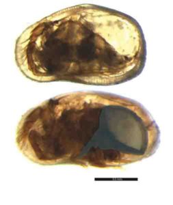
Localization and geometry of the “Unit 2” corresponding to the sediment body originated by the Zanclean mega flood. Credit: Aaron Micallef (University of Malta)
A study conducted by an international team of scientists has found new evidence supporting the hypothesis of a mega-flood occurring during the Zanclean period, in which water from the Atlantic poured back into the Mediterranean sea and ended the Messinian Salinity Crisis (MSC) 5 million years ago. The study, led by Professor Aaron Micallef from the University of Malta, has been published in the Scientific Reports journal.
Using seismic profiles and borehole data from offshore eastern Sicily, researchers have identified a large body of sediments buried in the subsurface of Sicily Channel which are characterized as being “extensive” and “chaotic.” They have named this mass of material Unit 2.
The study says that this huge mass of sediments is composed of materials eroded and transported by the great flow of water that flooded the Ionian Basin through the Strait of Sicily once the western basin of the Mediterranean was refilled with the contribution of water coming from the Atlantic Ocean that had poured in previously through the Strait of Gibraltar. This event is known as Zanclean megaflood.
The discovered sediments have been located over a layer of salts originated previously during the partial desiccation of the Mediterranean Sea during the MSC and under another layer of common marine sediments that were deposited after the flood and during the restoration of the normal marine conditions.
“The deposits identified in our study have little reflectivity of the seismic waves, they are seismically transparent, and present a disordered internal structure of the layers which is very similar to the sediments typically originated in catastrophic floods,” explains Daniel García-Castellanos, co-author of the study and researcher from Barcelona’s Institute of Earth Sciences Jaume Almera of the CSIC (ICTJA-CSIC).
The study indicates that the sedimentary body found next to the base of the Malta Escarpment, between the eastern and western Mediterranean Sea, is wedge-shaped, and its estimated thickness is up to 860 meters in some parts. According to the researchers, it would be the largest known megaflood deposit on Earth.
“According to the models of the paper that we published in Nature in 2009, the flood would have lasted only a few years, reaching discharges of up to 100 million cubic meters per second, about a rate thousand times the current flow of the Amazon River,” adds García-Castellanos.
Researchers have also identified a spot in the channel of Sicily as the most likely gateway for the eastern Mediterranean Zanclean flood across the Malta escarpment, the submarine canyon of Noto (southeast Sicily). The authors of the study explain that this canyon has a unique morphology—its amphitheatre-shaped head is 6 km wide and is “similar to that of bedrock canyons rapidly eroded by megafloods. “The researchers interpret the Noto submarine canyon as the collector of the cascading flow into the Ionian Basin.
The study points to the abrupt and catastrophic nature of the environmental changes that occurred during the Messinian period, the most important since the dinosaurs’ extinction 65 million years ago,” says Daniel García-Castellanos.
The Messinian Salinity Crisis: an unrecognizable Mediterranean Sea
About 6 million years ago, the connection between the Atlantic Ocean and the Mediterranean Sea was interrupted. This event led to the partial desiccation of the Mediterranean Sea, which became a giant saline lake, with an estimated sea-level drawdown of 1300-2400 meters. This event is known as Messinian Salinity Crisis (MSC).
A major open question about this period is how normal marine conditions were restored. The hypothesis of the Zanclean megaflood proposes that there was a massive inflow of water through the Strait of Gibraltar that first flooded the western Mediterranean Basin. Then, through the Strait of Sicily, which was once the division between the eastern and western basins, flooded the Ionian Basin. Some studies indicate that this filling process lasted between a few months and two years.
Reference:
Micallef, A., et al. (2018), Evidence of the Zanclean megaflood in the eastern Mediterranean Basin, Scientific Reports, 8(1), 1078, DOI: 10.1038/s41598-018-19446-3
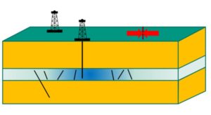
Model of a plant with one or several boreholes. Credit: ERDÖL ERDGAS KOHLE
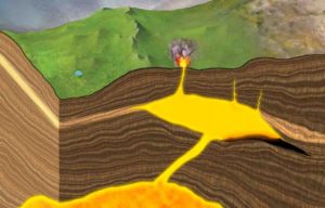
When constructing geothermal systems for the extraction of heat from underground hot water reservoirs, optimal positioning of the boreholes can considerably reduce seismicity. This is the result of induced seismicity studies by scientists of Karlsruhe Institute of Technology (KIT). Induced seismicity means shocks caused by human activities. Based on the change of water pressure in the rock (pore pressure) and the mechanical stresses in the rock, the researchers modeled changes of the stress field as a result of the injection and extraction of fluids, e.g. gases or liquids. This is reported in the journal ERDÖL ERDGAS KOHLE.
Injection of liquids into the underground e.g. at geothermal facilities, when injecting wastewater, or for the geological storage of carbon dioxide as well as the removal of fluids for e.g. natural gas production may cause noticeable tremors. These earthquakes caused by human activities (induced seismicity) are based on mechanical principles: Both injection and extraction change the pore pressure, i.e. the water pressure , and, hence, the stress state in the rock. As a result, natural fracture surfaces in the underground may be displaced relative to each other, similar to a small natural earthquake.
Based on this poroelastic coupling of pore pressure and stress, Dr. Birgit Müller und Professor Frank Schilling of KIT’s Institute of Applied Geosciences and the State Geothermal Energy Research Center located at KIT have now studied the seismicity induced by injection and extraction. The project was carried out in cooperation with researchers of the German Research Centre for Geosciences (GFZ) in Potsdam and the engineering office Piewak & Partners, Bayreuth. “For disruptions in the underground of variable orientation, such as fracture surfaces, it is possible to calculate whether induced seismicity can be expected to result from geoengineering activities. From this, recommendations can be derived for the positioning of boreholes and production operation in order to reduce the risk of induced seismicity,” Dr. Birgit Müller summarizes the results published in the journal ERDÖL ERDGAS KOHLE.
The findings are of high relevance to hydrothermal systems for the use of deep geothermal energy, which extract heat from the hot water circulating in an underground reservoir. Water is pumped out at one point and, after cooling down, injected into the ground again at another point. “Our modeling results show that the probability and extent of induced seismicity in hydrothermal systems can be reduced significantly by an active pore pressure management in the reservoir as well as by optimal positioning of the boreholes relative to the orientation of tectonic stresses,” Dr. Birgit Müller says.
Reference:
Induced Seismicity in Reservoirs: Stress Makes the Difference. ERDÖL ERDGAS KOHLE, DOI: 10.19225/180106
Using transmission electron microscopy, EPFL scientists have examined a slice from a meteorite that contains large diamonds formed at high pressure. The study shows that the parent body from which the meteorite came was a planetary embryo of a size between Mercury and Mars. The discovery is published in Nature Communications.
On October 7, 2008, an asteroid entered Earth’s atmosphere and exploded 37 km above the Nubian Desert in Sudan. The asteroid, now known as “2008 TC3,” was just over four meters in diameter. When it exploded in the atmosphere, it scattered multiple fragments across the desert. Only fifty fragments, ranging in size from 1-10 cm, were collected, for a total mass of 4.5 kg. Over time, the fragments were gathered and catalogued for study into a collection named Almahata Sitta (Arabic for “Station Six,” after a nearby train station between Wadi Halfa and Khartoum).
The Almahata Sitta meteorites are mostly ureilites, a rare type of stony meteorite that often contains clusters of nano-sized diamonds. Current thinking is that these tiny diamonds can form in three ways: enormous pressure shockwaves from high-energy collisions between the meteorite “parent body” and other space objects; deposition by chemical vapor; or, finally, the “normal” static pressure inside the parent body, like most diamonds on Earth.
The unanswered question, so far, has been the planetary origin of 2008 TC3 ureilites. Now, scientists at Philippe Gillet’s lab at EPFL, with colleagues in France and Germany, have studied large diamonds (100-microns in diameter) in some of the Almahata Sitta meteorites and discovered that the asteroid came from a planetary “embryo” whose size is between Mercury to Mars.
The researchers studied the diamond samples using a combination of advanced transmission electron microscopy techniques at EPFL’s Interdisciplinary Centre for Electron Microscopy. The analysis of the data showed that the diamonds had chromite, phosphate, and iron-nickel sulfides embedded in them — what scientists refer to as “inclusions.” These have been known for a long time to exist inside Earth’s diamonds, but are now described for the first time in an extraterrestrial body.
The particular composition and morphology of these materials can only be explained if the pressure under which the diamonds were formed was higher than 20 GPa (giga-Pascals, the unit of pressure). This level of internal pressure can only be explained if the planetary parent body was a Mercury- to Mars-sized planetary “embryo,” depending on the layer in which the diamonds were formed.
Many planetary formation models have predicted that these planetary embryos existed in the first million years of our solar system, and the study offers compelling evidence for their existence. Many planetary embryos were Mars-sized bodies, such as the one that collided with Earth to give rise to the Moon. Other of these went on to form larger planets, or collided with the Sun or were ejected from the solar system altogether. The authors write “This study provides convincing evidence that the ureilite parent body was one such large ‘lost’ planet before it was destroyed by collisions some 4.5 billion years ago.”
Reference:
Farhang Nabiei, James Badro, Teresa Dennenwaldt, Emad Oveisi, Marco Cantoni, Cécile Hébert, Ahmed El Goresy, Jean-Alix Barrat, Philippe Gillet. A large planetary body inferred from diamond inclusions in a ureilite meteorite. Nature Communications, 2018; 9 (1) DOI: 10.1038/s41467-018-03808-6
This is a reconstruction of the new species (Peritresius martini). Credit: Drew Gentry CC-BY
A sea turtle discovered in Alabama is a new species from the Late Cretaceous epoch, according to a study published April 18, 2018 in the open-access journal PLOS ONE by Drew Gentry from the University of Alabama at Birmingham, Alabama, USA, and colleagues.
Modern day sea turtles were previously thought to have had a single ancestor of the of the Peritresius clade during the Late Cretaceous epoch, from about 100 to 66 million years ago. This ancestral species, Peritresius ornatus, lived exclusively in North America, but few Peritresius fossils from this epoch had been found in what is now the southeastern U.S., an area known for producing large numbers of Late Cretaceous marine turtle fossils. In this study, the research team analyzed sea turtle fossils collected from marine sediments in Alabama and Mississippi, dating from about 83 to 66 million years ago.
The researchers identified some of the Alabama fossils as representing a new Peritresius species, which they named Peritresius martini after Mr. George Martin who discovered the fossils. Their identification was based on anatomical features including the shape of the turtle’s shell. Comparing P. martini and P. ornatus, the researchers noted that the shell of P. ornatus is unusual amongst Cretaceous sea turtles in having sculptured skin elements which are well-supplied with blood vessels. This unique feature may suggest that P. ornatus was capable of thermoregulation, which could have enabled Peritresius to keep warm and survive during the cooling period of the Cretaceous, unlike many other marine turtles that went extinct.
These findings extend the known evolutionary history for thePeritresius clade to include two anatomically distinct species from the Late Cretaceous epoch, and also reveal that Peritresius was distributed across a wider region than previously thought.
Drew Gentry says: “This discovery not only answers several important questions about the distribution and diversity of sea turtles during this period but also provides further evidence that Alabama is one of the best places in the world to study some of the earliest ancestors of modern sea turtles.”
Reference:
Andrew D. Gentry, James F. Parham, Dana J. Ehret, Jun A. Ebersole. A new species of Peritresius Leidy, 1856 (Testudines: Pan-Cheloniidae) from the Late Cretaceous (Campanian) of Alabama, USA, and the occurrence of the genus within the Mississippi Embayment of North America. PLOS ONE, 2018; 13 (4): e0195651 DOI: 10.1371/journal.pone.0195651
Note: The above post is reprinted from materials provided by PLOS.
University of Otago palaeontologists are rewriting the history of New Zealand’s ancient whales by describing a previously unknown genus of baleen whale, alive more than 27.5 million years ago and found in the Hakataramea Valley.
The new genus and species of extinct baleen whale is based on a skull and associated bones unearthed from the Kokoamu Greensand, a noted fossil-bearing rock unit in the South Canterbury and Waitaki district from the Oligocene period, which extends from about 33.9 million to 23 million years ago. At this time, New Zealand was an archipelago surrounded by shallow, richly productive seas.
Former PhD student in the University of Otago’s Department of Geology, Cheng-Hsiu Tsai and his supervisor, Professor Ewan Fordyce, have named the new genus Toipahautea waitaki, which translates in Māori as a baleen-origin whale from the Waitaki region.
Professor Fordyce says the discovery is significant in New Zealand’s fossil history.
“This is a pretty old whale that goes almost half-way back to the age of the dinosaurs. We are tracking whale history back through time,” Professor Fordyce explains.
“This newly-named whale lived about 27.5 million years ago. It’s about as old a common ancestor as we have for the living baleen whales like the minke whales and the right whales.”
Baleen whales are a group of Mysticeti, large whales usually from colder waters that lack teeth but have baleen plates in the upper jaw which are used to filter food such as krill out of large quantities of seawater.
The fossil was actually recovered from the Hakataramea Valley in South Canterbury 30 years ago in January 1988. However, it was only worked up in recent years with Dr Tsai — who is now currently working at the National Taiwan University — beginning his thesis only a few years ago. The thesis provided the analytical framework to identify and name the new whale.
The research paper announcing the new archaic baleen whale was published today in the scientific journal Royal Society Open Science.
While the skeleton of the whale was disarticulated when it was excavated, the bones were closely associated, which gave the palaeontologists plenty of material to work with. In particular, the highly diagnostic earbones were preserved, helping with identification.
The skull was about one metre long and the body about five metres, which means it was a reasonably small species, Professor Fordyce says. “That’s about half the size of an adult minke whale.”
It was previously known that the baleen whales can take on board thousands of litres of water in the lower jaws which they scoop open to get great mouthfuls of water and food. Toipahautea waitaki’s jaws were toothless, long and narrow, Professor Fordyce says, suggesting that it fed in a similar way to the modern-day minke whales.
The researchers were not able to determine how this whale died. Professor Fordyce says it could have been attacked by a shark, stranded on a beach or died of disease. When it died, it sank to the bottom of the sea floor with its skeleton falling apart and becoming a hub for coral and other organisms to grow on.
Professor Fordyce expects the ancient whales’ history books may keep being rewritten in years to come.
“We are pretty sure there are some species [of baleen whale] that will be older than these. But right now it anchors the modern baleen whale lineage to at least 27.5 million years.”
The Toipahautea waitaki fossil was collected during fieldwork funded by a grant from the National Geographic Society with further lab work also funded by the Society.
Reference:
Cheng-Hsiu Tsai, R. Ewan Fordyce. A new archaic baleen whale Toipahautea waitaki (early Late Oligocene, New Zealand) and the origins of crown Mysticeti. Royal Society Open Science, 2018; 5 (4): 172453 DOI: 10.1098/rsos.172453
A life-sized display of Archie, a Columbian mammoth, is on display at the University of Nebraska State Museum in Morrill Hall. A new study suggests that such massive mammals were much more likely than their smaller counterparts to go extinct in regions occupied by ancient humans. Credit: Troy Fedderson, University Communication
Homo sapiens, Neanderthals and other recent human relatives may have begun hunting large mammal species down to size — by way of extinction — at least 90,000 years earlier than previously thought, says a new study published in the journal Science.
Elephant-dwarfing wooly mammoths, elephant-sized ground sloths and various saber-toothed cats highlighted the array of massive mammals roaming Earth between 2.6 million and 12,000 years ago. Prior research suggested that such large mammals began disappearing faster than their smaller counterparts — a phenomenon known as size-biased extinction — in Australia around 35,000 years ago.
With the help of emerging data from older fossil and rock records, the new study estimated that this size-biased extinction started at least 125,000 years ago in Africa. By that point, the average African mammal was already 50 percent smaller than those on other continents, the study reported, despite the fact that larger landmasses can typically support larger mammals.
But as humans migrated out of Africa, other size-biased extinctions began occurring in regions and on timelines that coincide with known human migration patterns, the researchers found. Over time, the average body size of mammals on those other continents approached and then fell well below Africa’s. Mammals that survived during the span were generally far smaller than those that went extinct.
The magnitude and scale of the recent size-biased extinction surpassed any other recorded during the last 66 million years, according to the study, which was led by the University of New Mexico’s Felisa Smith.
“It wasn’t until human impacts started becoming a factor that large body sizes made mammals more vulnerable to extinction,” said the University of Nebraska-Lincoln’s Kate Lyons, who authored the study with Smith and colleagues from Stanford University and the University of California, San Diego. “The anthropological record indicates that Homo sapiens are identified as a species around 200,000 years ago, so this occurred not very long after the birth of us as a species. It just seems to be something that we do.
“From a life-history standpoint, it makes some sense. If you kill a rabbit, you’re going to feed your family for a night. If you can kill a large mammal, you’re going to feed your village.”
By contrast, the research team found little support for the idea that climate change drove size-biased extinctions during the last 66 million years. Large and small mammals seemed equally vulnerable to temperature shifts throughout that span, the authors reported.
“If climate were causing this, we would expect to see these extinction events either sometimes (diverging from) human migration across the globe or always lining up with clear climate events in the record,” said Lyons, assistant professor of biology at Nebraska. “And they don’t do either of those things.”
Off the Face of the Earth
The team also looked ahead to examine how potential mammal extinctions could affect the world’s biodiversity. To do so, it posed a question: What would happen if the mammals currently listed as vulnerable or endangered were to go extinct within the next 200 years?
In that scenario, Lyons said, the largest remaining mammal would be the domestic cow. The average body mass would plummet to less than six pounds — roughly the size of a Yorkshire terrier.
“If this trend continues, and all the currently threatened (mammals) are lost, then energy flow and taxonomic composition will be entirely restructured,” said Smith, professor of biology at New Mexico. “In fact, mammalian body size around the globe will revert to what the world looked like 40 million years ago.”
Lyons said that restructuring could have “profound implications” for the world’s ecosystems. Large mammals tend to be herbivores, devouring large quantities of vegetation and effectively transporting the associated nutrients around an ecosystem. If they continue to disappear, she said, the remaining mammals would prove poor stand-ins for important ecological roles.
“The kinds of ecosystem services that are provided by large mammals are very different than what you get from small mammals,” Lyons said. “Ecosystems are going to be very, very different in the future. The last time mammal communities looked like that and had a mean body size that small was after the extinction of the dinosaurs.
“What we’re doing is potentially erasing 40 to 45 million years of mammal body-size evolution in a very short period of time.”
Smith and Lyons authored the study with Jon Payne of Stanford University and Rosemary Elliott Smith from the University of California, San Diego. The team received support from the National Science Foundation.
Reference:
Felisa A. Smith, Rosemary E. Elliott Smith, S. Kathleen Lyons, Jonathan L. Payne. Body size downgrading of mammals over the late Quaternary. Science, 2018; DOI: 10.1126/science.aao5987
A scene from 232 million years ago, during the Carnian Pluvial Episode after which dinosaurs took over. A large rauisuchian lurks in the background, while two species of dinosaurs stand in the foreground. Based on data from the Ischigualasto Formation in Argentina. Credit: Davide Bonadonna.
It is commonly understood that the dinosaurs disappeared with a bang — wiped out by a great meteorite impact on the Earth 66 million years ago.
But their origins have been less understood. In a new study, scientists from MUSE — Museum of Science, Trento, Italy, Universities of Ferrara and Padova, Italy and the University of Bristol show that the key expansion of dinosaurs was also triggered by a crisis — a mass extinction that happened 232 million years ago.
In the new paper, published today in Nature Communications, evidence is provided to match the two events — the mass extinction, called the Carnian Pluvial Episode, and the initial diversification of dinosaurs.
Dinosaurs had originated much earlier, at the beginning of the Triassic Period, some 245 million years ago, but they remained very rare until the shock events in the Carnian 13 million years later.
The new study shows just when dinosaurs took over by using detailed evidence from rock sequences in the Dolomites, in north Italy — here the dinosaurs are detected from their footprints.
First there were no dinosaur tracks, and then there were many. This marks the moment of their explosion, and the rock successions in the Dolomites are well dated. Comparison with rock successions in Argentina and Brazil, here the first extensive skeletons of dinosaurs occur, show the explosion happened at the same time there as well.
Lead author Dr Massimo Bernardi, Curator at MUSE and Research associate at Bristol’s School of Earth Sciences, said: “We were excited to see that the footprints and skeletons told the same story. We had been studying the footprints in the Dolomites for some time, and it’s amazing how clear cut the change from ‘no dinosaurs’ to ‘all dinosaurs’ was.”
The point of explosion of dinosaurs matches the end of the Carnian Pluvial Episode, a time when climates shuttled from dry to humid and back to dry again.
It was long suspected that this event had caused upheavals among life on land and in the sea, but the details were not clear. Then, in 2015, dating of rock sections and measurement of oxygen and carbon values showed just what had happened.
There were massive eruptions in western Canada, represented today by the great Wrangellia basalts — these drove bursts of global warming, acid rain, and killing on land and in the oceans.
Co-author Piero Gianolla, from the University of Ferrara, added: “We had detected evidence for the climate change in the Dolomites. There were four pulses of warming and climate perturbation, all within a million years or so. This must have led to repeated extinctions.”
Professor Mike Benton, also a co-author, from the University of Bristol, said: “The discovery of the existence of a link between the first diversification of dinosaurs and a global mass extinction is important.
“The extinction didn’t just clear the way for the age of the dinosaurs, but also for the origins of many modern groups, including lizards, crocodiles, turtles, and mammals — key land animals today.”
Reference:
Massimo Bernardi, Piero Gianolla, Fabio Massimo Petti, Paolo Mietto, Michael J. Benton. Dinosaur diversification linked with the Carnian Pluvial Episode. Nature Communications, 2018; 9 (1) DOI: 10.1038/s41467-018-03996-1
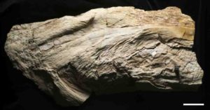
A photo of the Platylithophycus cretaceus specimen. The scale bar is 5 centimeters. Credit: Mike Eklund
A fossil slab discovered in Kansas 70 years ago and twice misidentified — first as a green alga and then as a cephalopod — has been reinterpreted as the preserved remains of a large cartilaginous fish, the group that includes sharks and rays. In a study published in the Journal of Paleontology, American Museum of Natural History researchers describe the fishy characteristics of the animal, which lived between 70-85 million years ago.
“There are many examples of temporarily misplaced taxa in paleontological history, including ferns that were once thought to be sponges and lungfish teeth thought to be fungi,” said the lead author, Allison Bronson, a comparative biology Ph.D.-degree student in the Museum’s Richard Gilder Graduate School. “In this case, the misidentification didn’t happen because of a lack of technology at the time — scientists familiar with cartilage structure could easily see this was a chondrichthyan fish. The researchers used reasonable arguments for their interpretations, but didn’t look outside of their own fields.”
The enigmatic specimen, Platylithophycus cretaceum, is roughly 1.5-feet long by 10-inches wide and from the Niobrara Formation in Kansas. The Niobrara Formation is one of the most diverse fish-fossil sites in North America, preserving late Cretaceous animals that lived in and around the Western Interior Seaway, a broad expanse of water that split North America into two land masses.
In 1948, two paleobotanists from the Colorado School of Mines and Princeton University compared the texture of the fossil slab with that of green algae. They described two parts of a plant: surfaces covered with hexagonal plates, which they called “fronds,” and supposedly calcium carbonate-covered thread-like filaments. In 1968, two researchers from Fort Hays Kansas State College studying cephalopods from the Niobrara Formation compared the specimen with a cuttlefish, based primarily on its textural similarities to a cuttlebone — the unique internal shell of cuttlefish. The reclassification made Platylithophycus the oldest sepiid squid then on record.
In both of these earlier studies, the hard tissue was assumed to be composed of calcium carbonate, but no tests were performed. For the new study, Bronson and co-author John Maisey, a curator in the Museum’s Division of Paleontology, applied a small amount of dilute organic acid to the specimen — a method that has been widely used in paleontology since the time of the initial description of Platylithophycus. If there is a reaction, the fossilized material is likely made from calcium carbonate. But if there is no reaction, which was the case when Bronson and Maisey performed the test, it is likely made from calcium phosphate, as are the fossilized skeletons of cartilaginous fish like sharks and rays.
The most obvious clue that Platylithophycus was a cartilaginous fish are the hexagonal plates on the surface of the specimen. After taking a closer look with a scanning electron microscope, Bronson and Maisey reinterpreted that feature as tessellated calcified cartilage, found on both extinct and living sharks and rays. The new study suggests that the “filaments” earlier described are actually part of the gill arches, made up of tessellated cartilage. Gill arches are cartilaginous curved bars along the pharynx, or throat, that support the gills of fish. The “fronds” are reinterpreted as gill rakers, finger-like projections that extend from the gill arches and help with feeding.
“We think this was a rather large cartilaginous fish, possibly related to living filter-feeding rays such as Manta and Mobula,” Maisey said. “This potentially expands the range of diversity in the Niobrara fauna.”
But because this fossil only preserves the animal’s gills and no additional identifying features like teeth, it cannot be given a new name or reunited with an existing species. So until then, this fish will still carry the name of a plant.
Reference:
Allison W. Bronson, John G. Maisey. Resolving the identity of Platylithophycus, an enigmatic fossil from the Niobrara Chalk (Upper Cretaceous, Coniacian–Campanian). Journal of Paleontology, 2018; 1 DOI: 10.1017/jpa.2018.14
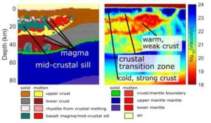
Graphic by University of Oregon scientists provides new structural information, based on supercomputer modeling, about the location of a mid-crustal sill that separates magma under Yellowstone. Credit: Courtesy of Dylan Colon
Using supercomputer modeling, University of Oregon scientists have unveiled a new explanation for the geology underlying recent seismic imaging of magma bodies below Yellowstone National Park.
Yellowstone, a supervolcano famous for explosive eruptions, large calderas and extensive lava flows, has for years attracted the attention of scientists trying to understand the location and size of magma chambers below it. The last caldera forming eruption occurred 630,000 years ago; the last large volume of lava surfaced 70,000 years ago.
Crust below the park is heated and softened by continuous infusions of magma that rise from an anomaly called a mantle plume, similar to the source of the magma at Hawaii’s Kilauea volcano. Huge amounts of water that fuel the dramatic geysers and hot springs at Yellowstone cool the crust and prevent it from becoming too hot.
With computer modeling, a team led by UO doctoral student Dylan P. Colón has shed light on what’s going on below. At depths of 5-10 kilometers (3-6 miles) opposing forces counter each other, forming a transition zone where cold and rigid rocks of the upper crust give way to hot, ductile and even partially molten rock below, the team reports in a paper in Geophysical Research Letters.
This transition traps rising magmas and causes them to accumulate and solidify in a large horizontal body called a sill, which can be up to 15 kilometers (9 miles) thick, according to the team’s computer modeling.
“The results of the modeling matches observations done by sending seismic waves through the area,” said co-author Ilya Bindeman, a professor in the UO’s Department of Earth Sciences. “This work appears to validate initial assumptions and gives us more information about Yellowstone’s magma locations.”
This mid-crustal sill is comprised of mostly solidified gabbro, a rock formed from cooled magma. Above and below lay separate magma bodies. The upper one contains the sticky and gas-rich rhyolitic magma that occasionally erupts in explosions that dwarf the 1980 eruption of Mount St. Helens in Washington state.
Similar structures may exist under super volcanoes around the world, Colón said. The geometry of the sill also may explain differing chemical signatures in eruptive materials, he said.
Colón’s project to model what’s below the nation’s first national park, which was sculpted 2 million years ago by volcanic activity, began soon after a 2014 paper in Geophysical Research Letters by a University of Utah-led team revealed evidence from seismic waves of a large magma body in the upper crust.
Scientists had suspected, however, that huge amounts of carbon dioxide and helium escaping from the ground indicated that more magma is located farther down. That mystery was solved in May 2015, when a second University of Utah-led study, published in the journal Science, identified by way of seismic waves a second, larger body of magma at depths of 20 to 45 kilometers (12-27 miles).
However, Colón said, the seismic-imaging studies could not identify the composition, state and amount of magma in these magma bodies, or how and why they formed there.
To understand the two structures, UO researchers wrote new codes for supercomputer modeling to understand where magma is likely to accumulate in the crust. The work was done in collaboration with researchers at the Swiss Federal Institute of Technology, also known as ETH Zurich.
The researchers repeatedly got results indicating a large layer of cooled magma with a high melting point forms at the mid-crustal sill, separating two magma bodies with magma at a lower melting point, much of which is derived from melting of the crust.
“We think that this structure is what causes the rhyolite-basalt volcanism throughout the Yellowstone hotspot, including supervolcanic eruptions,” Bindeman said. “This is the nursery, a geological and petrological match with eruptive products. Our modeling helps to identify the geologic structure of where the rhyolitic material is located.”
The new research, for now, does not help to predict the timing of future eruptions. Instead, it provides a never-before-seen look that helps explain the structure of the magmatic plumbing system that fuels these eruptions, Colón said. It shows where the eruptible magma originates and accumulates, which could help with prediction efforts further down the line.
“This research also helps to explain some of the chemical signatures that are seen in eruptive materials,” Colón said. “We can also use it to explore how hot the mantle plume is by comparing models of different plumes to the actual situation at Yellowstone that we understand from the geologic record.”
Colón is now exploring what influences the chemical composition of magmas that erupt at volcanoes like Yellowstone.
Studying the interaction of rising magmas with the crustal transition zone, and how this influences the properties of the magma bodies that form both above and below it, the scientists wrote, should boost scientific understanding of how mantle plumes influence the evolution and structure of continental crust.
Reference:
D. P. Colón, I. N. Bindeman, T. V. Gerya. Thermomechanical modeling of the formation of a multilevel, crustal-scale magmatic system by the Yellowstone plume. Geophysical Research Letters, 2018; DOI: 10.1029/2018GL077090
Note: The above post is reprinted from materials provided by University of Oregon.
How do we really know there weren’t previous industrial civilizations on Earth that rose and fell long before human beings appeared? That’s the question posed in a scientific thought experiment by University of Rochester astrophysicist Adam Frank. Credit: University of Rochester illustration/Michael Osadciw
Imagine if, many millions of years ago, dinosaurs drove cars through cities of mile-high buildings. A preposterous idea, right? Over the course of tens of millions of years, however, all of the direct evidence of a civilization — its artifacts and remains — gets ground to dust. How do we really know, then, that there weren’t previous industrial civilizations on Earth that rose and fell long before human beings appeared?
It’s a compelling thought experiment, and one that Adam Frank, a professor of physics and astronomy at the University of Rochester, and Gavin Schmidt, the director of the NASA Goddard Institute for Space Studies, take up in a paper published in the International Journal of Astrobiology.
“Gavin and I have not seen any evidence of another industrial civilization,” Frank explains. But by looking at the deep past in the right way, a new set of questions about civilizations and the planet appear: What geological footprints do civilizations leave? Is it possible to detect an industrial civilization in the geological record once it disappears from the face of its host planet? “These questions make us think about the future and the past in a much different way, including how any planetary-scale civilization might rise and fall.”
In what they deem the “Silurian Hypothesis,” Frank and Schmidt define a civilization by its energy use. Human beings are just entering a new geological era that many researchers refer to as the Anthropocene, the period in which human activity strongly influences the climate and environment. In the Anthropocene, fossil fuels have become central to the geological footprint humans will leave behind on Earth. By looking at the Anthropocene’s imprint, Schmidt and Frank examine what kinds of clues future scientists might detect to determine that human beings existed. In doing so, they also lay out evidence of what might be left behind if industrial civilizations like ours existed millions of years in the past.
Human beings began burning fossil fuels more than 300 years ago, marking the beginnings of industrialization. The researchers note that the emission of fossil fuels into the atmosphere has already changed the carbon cycle in a way that is recorded in carbon isotope records. Other ways human beings might leave behind a geological footprint include:
Global warming, from the release of carbon dioxide and perturbations to the nitrogen cycle from fertilizers
Agriculture, through greatly increased erosion and sedimentation rates
Plastics, synthetic pollutants, and even things such as steroids, which will be geochemically detectable for millions, and perhaps even billions, of years
Nuclear war, if it happened, which would leave behind unusual radioactive isotopes
“As an industrial civilization, we’re driving changes in the isotopic abundances because we’re burning carbon,” Frank says. “But burning fossil fuels may actually shut us down as a civilization. What imprints would this or other kinds of industrial activity from a long dead civilization leave over tens of millions of years?”
The questions raised by Frank and Schmidt are part of a broader effort to address climate change from an astrobiological perspective, and a new way of thinking about life and civilizations across the universe. Looking at the rise and fall of civilizations in terms of their planetary impacts can also affect how researchers approach future explorations of other planets.
“We know early Mars and, perhaps, early Venus were more habitable than they are now, and conceivably we will one day drill through the geological sediments there, too,” Schmidt says. “This helps us think about what we should be looking for.”
Schmidt points to an irony, however: if a civilization is able to find a more sustainable way to produce energy without harming its host planet, it will leave behind less evidence that it was there.
“You want to have a nice, large-scale civilization that does wonderful things but that doesn’t push the planet into domains that are dangerous for itself, the civilization,” Frank says. “We need to figure out a way of producing and using energy that doesn’t put us at risk.”
That said, the earth will be just fine, Frank says. It’s more a question of whether humans will be.
Can we create a version of civilization that doesn’t push the earth into a domain that’s dangerous for us as a species?
“The point is not to ‘save the earth,'” says Frank. “No matter what we do to the planet, we’re just creating niches for the next cycle of evolution. But, if we continue on this trajectory of using fossil fuels and ignoring the climate change it drives, we human beings may not be part of Earth’s ongoing evolution.”
Reference:
Gavin A. Schmidt, Adam Frank. The Silurian hypothesis: would it be possible to detect an industrial civilization in the geological record? International Journal of Astrobiology, 2018; 1 DOI: 10.1017/S1473550418000095
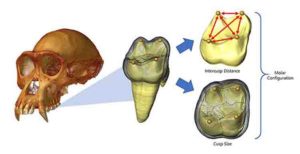
CT-rendered chimpanzee cranium (left) with enlarged image of a virtually extracted molar (middle). The outer layer, called enamel, is rendered transparent revealing the 3-D landscape of a molar’s underlying dentine core. The location of embryonic signaling cells that will determine future cusp position is indicated by yellow spheres (middle). The distribution of these signaling centers across the dentine landscape is measured as a series of intercusp distances (red arrows in right, top), which determines the number of cusps that will ultimately develop across a molar crown, as well as the amount of terrain mapped out by each cusp (dashed lines in right, bottom). Credit: Alejandra Ortiz and Gary Schwartz
Across the world of mammals, teeth come in all sorts of shapes and sizes. Their particular size and shape are the process of millions of years of evolutionary fine-tuning to produce teeth that can effectively break down the foods in an animal’s diet. As a result, mammals that are closely related and have a similar menu tend to have teeth that look fairly similar. New research suggests, however, that these similarities may only be “skin deep.”
The teeth at the back of our mouths — the molars — have a series of bumps, ridges, and grooves across the chewing surface. This complex dental landscape is the product of the spatial arrangement of cusps, which are conical surface projections that crush food before swallowing. How many cusps there are, how they are positioned, and what size and shape they take together determine our molar’s overall form or configuration.
Over the course of hominin (modern humans and their fossil ancestors) evolution, molars have changed markedly in their configuration, with some groups developing larger cusps and others evolving molars with a battery of smaller extra cusps.
Charting these changes has yielded powerful insights into our understanding of modern human population history. It has even allowed us to identify new fossil hominin species, sometimes from just fragmentary tooth remains, and to reconstruct which species is more closely related to whom. Exactly how some populations of modern humans, and some fossil hominin species, evolved complex molars with many cusps of varying sizes, while others evolved more simplified molar configurations, however, is unknown.
In a study published this week in Science Advances, an international team of researchers from Arizona State University’s Institute of Human Origins and School of Human Evolution and Social Change, New York University, University of Kent, and the Max Planck Institute for Evolutionary Anthropology found that a simple, straightforward developmental rule — the “patterning cascade” — is powerful enough to explain the massive variability in molar crown configuration over the past 15 million years of ape and human evolution.
“Instead of invoking large, complicated scenarios to explain the majors shifts in molar evolution during the course of hominin origins, we found that simple adjustments and alterations to this one developmental rule can account for most of those changes,” says Alejandra Ortiz, a postdoctoral researcher at Arizona State University’s Institute of Human Origins and lead author of the study.
In the past decade, researchers’ understanding of molar cusp development has increased one hundred-fold. They now know that the formation of these cusps is governed by a molecular process that starts at an early embryonic stage. Based on experimental work on mice, the patterning cascade model predicts that molar configuration is primarily determined by the spatial and temporal distribution of a set of signaling cells.
Clumps of signaling cells (and their resultant cusps) that develop earlier strongly influence the expression of cusps that develop later. This cascading effect can result in either favoring an increase in the size and number of additional cusps or constraining their development to produce smaller, fewer cusps. Whether this sort of simple developmental ratchet phenomenon could explain the vast array of molar configurations present across ape and human ancestry was unknown.
Using state-of-the-art micro-computed tomography and digital imaging technology applied to hundreds of fossil and recent molars, Ortiz and colleagues created virtual maps of the dental landscape of developing teeth to chart the precise location of embryonic signaling cells from which molar cusps develop. To the research team’s great surprise, the predictions of the model held up, not just for modern humans, but for over 17 ape and hominin species spread out across millions of years of higher primate evolution and diversification.
“Not only does the model work for explaining differences in basic molar design, but it is also powerful enough to accurately predict the range of variants in size, shape, and additional cusp presence, from the most subtle to the most extreme, for most apes, fossil hominins, and modern humans,” says Ortiz.
These results fit with a growing body of work within evolutionary developmental biology that very simple, straightforward developmental rules are responsible for the generation of the myriad complexity of dental features found within mammalian teeth.
“The most exciting result was how well our results fit with an emerging view that evolution of complex anatomy proceeds by small, subtle tweaks to the underlying developmental toolkit rather than by major leaps,” says Gary Schwartz, a paleoanthropologist at ASU’s Institute of Human Origins and a study coauthor.
This new study is in line with the view that simple, subtle alterations in the ways genes code for complex features can result in the vast array of different dental configurations that we see across hominins and our ape cousins. It is part of a shift in our understanding of how natural selection can readily and rapidly generate novel anatomy suited to a particular function.
“That all of this precise, detailed information is contained deep within teeth,” continued Schwartz, “even teeth from our long-extinct fossil relatives, is simply remarkable.”
“Our research, demonstrating that a single developmental rule can explain the countless variation we observe across mammals, also means we must be careful about inferring relationships of extinct species based on shared form,” said Shara Bailey, a coauthor and paleoanthropologist at New York University. “It is becoming clearer that similarities in tooth form may not necessarily indicate recent shared ancestry,” added Bailey.
Reference:
Alejandra Ortiz, Shara E. Bailey, Gary T. Schwartz, Jean-Jacques Hublin, Matthew M. Skinner. Evo-devo models of tooth development and the origin of hominoid molar diversity. Science Advances, 2018; 4 (4): eaar2334 DOI: 10.1126/sciadv.aar2334
The Moeraki Boulders are unusually large and spherical boulders lying along a stretch of Koekohe Beach on the wave-cut Otago coast of New Zealand between Moeraki and Hampden. They occur scattered either as isolated or clusters of boulders within a stretch of beach where they have been protected in a scientific reserve. The erosion by wave action of mudstone, comprising local bedrock and landslides, frequently exposes embedded isolated boulders. These boulders are grey-colored septarian concretions, which have been exhumed from the mudstone enclosing them and concentrated on the beach by coastal erosion.
Local Māori legends explained the boulders as the remains of eel baskets, calabashes, and kumara washed ashore from the wreck of Arai-te-uru, a large sailing canoe. This legend tells of the rocky shoals that extend seaward from Shag Point as being the petrified hull of this wreck and a nearby rocky promontory as being the body of the canoe’s captain. In 1848 W.B.D. Mantell sketched the beach and its boulders, more numerous than now. The picture is now in the Alexander Turnbull Library in Wellington.[5] The boulders were described in 1850 colonial reports and numerous popular articles since that time. In more recent times they have become a popular tourist attraction, often described and pictured in web pages and tourist guides.
The most striking aspect of the boulders is their unusually large size and spherical shape, with a distinct bimodal size distribution. Approximately one-third of the boulders range in size from about 0.5 to 1.0 metre (1.6 to 3.3 ft) in diameter, the other two-thirds from 1.5 to 2.2 metres (4.9 to 7.2 ft). Most are spherical or almost spherical, but a small proportion are slightly elongated parallel to the bedding plane of the mudstone that once enclosed them.
Neither the spherical to subspherical shape or large size of the Moeraki Boulders is unique to them. Virtually identical spherical boulders, called Koutu Boulders, are found on the beaches, in the cliffs, and beneath the surface inland of the shore of Hokianga Harbour, North Island, New Zealand, between Koutu and Kauwhare points. Like the Moeraki Boulders, the Koutu Boulders are large, reaching 3 metres (10 ft) in diameter, and almost spherical.
Similar boulder-size concretions, known as Katiki Boulders, are also found on the north-facing shore of Shag Point some 19 kilometres (12 mi) south of where the Moeraki Boulders are found. These concretions occur as both spherical cannonball concretions and flat, disk-shaped or oval concretions. Unlike the Moeraki boulders, some of these concretions contain the bones of mosasaurs and plesiosaurs.
Large spherical concretions similar in size and shape to the Moeraki Boulders have been found in many other countries.
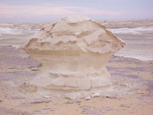
White Desert – Egypt
White Desert (known as Sahara el Beyda, with the word sahara meaning a desert). The White Desert of Egypt is located 45 km (28 mi) north of the town of Farafra. The desert has a white, cream color and has massive chalk rock formations that have been created as a result of occasional sandstorm in the area.
The majority of the valley is devoid of vegetation desert today. Rock and subsoil are usually made of limestone or chalk.
The valley is flat and is interrupted only by a few isolated standing conical hills – both north and south of the city of el-Farafra, they are called el-Qunna, mostly spoken el-Gunna (Arabic: القنة, al-Qunna, “the pinnacle “). East of el-Quss-Abu-Sa ? id plateaus are also numerous small limestone mountains witnesses.
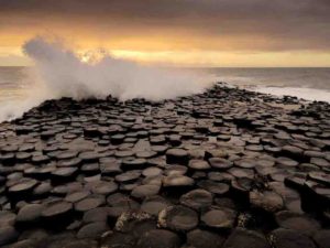
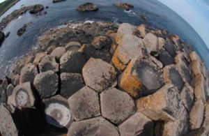
The Giant’s Causeway – Northern Ireland
The Giant’s Causeway – Northern Ireland
The Giant’s Causeway is an area of about 40,000 interlocking basalt columns, the result of an ancient volcanic fissure eruption. It is located in County Antrim on the north coast of Northern Ireland, about three miles (4.8 km) northeast of the town of Bushmills.
It was declared a World Heritage Site by UNESCO in 1986, and a national nature reserve in 1987 by the Department of the Environment for Northern Ireland. In a 2005 poll of Radio Times readers, the Giant’s Causeway was named as the fourth greatest natural wonder in the United Kingdom. The tops of the columns form stepping stones that lead from the cliff foot and disappear under the sea. Most of the columns are hexagonal, although there are also some with four, five, seven or eight sides. The tallest are about 12 metres (39 ft) high, and the solidified lava in the cliffs is 28 metres (92 ft) thick in places.
Much of the Giant’s Causeway and Causeway Coast World Heritage Site is today owned and managed by the National Trust and it is one of the most popular tourist attractions in Northern Ireland. The remainder of the site is owned by the Crown Estate and a number of private landowners.
Reed Flute Cave – Guangxi Province, China
Reed Flute Cave – Guangxi Province, China
The Reed Flute Cave is a landmark and tourist attraction in Guilin, Guangxi, China. It is a natural limestone cave with multicolored lighting and has been one of Guilin’s most interesting attractions for over 1200 years.
It is over 180 million years old. The cave got its name from the type of reed growing outside, which can be made into melodious flutes. Reed Flute Cave is filled with a large number of stalactites, stalagmites and rock formations in weird and wonderful shapes. Inside, there are more than 70 inscriptions written in ink, which can be dated back as far as 792 AD in the Tang Dynasty.
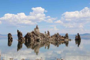
Mono Lake – California
Tufa columns, Mono Lake, Eastern Sierra, California. Credit: Vezoy/Wikipedia
Mono Lake is a large, shallow saline soda lake in Mono County, California, formed at least 760,000 years ago as a terminal lake in an endorheic basin. The lack of an outlet causes high levels
of salts to accumulate in the lake. These salts also make the lake water alkaline.
This desert lake has an unusually productive ecosystem based on brine shrimp that thrive in its waters, and provides critical nesting habitat for two million annual migratory birds that feed on the shrimp and blackflies (that also feed on the shrimp). Historically, the native Kutzadika’a people derived nutrition from the Ephydra hians pupae, which live in the shallow waters around the edge of the lake having been hatched from the eggs of adult alkali flies.
When the city of Los Angeles diverted water from the freshwater streams flowing into the lake, it lowered the lake level, which imperiled the migratory birds. The Mono Lake Committee formed in response and won a legal battle that forced Los Angeles to partially replenish the lake level.
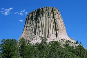
Devils Tower – Wyoming
Devils Tower. Photo Copyright: Wikipedia
Devils Tower was the first declared United States National Monument, established on September 24, 1906, by President Theodore Roosevelt. The Monument’s boundary encloses an area of 1,347 acres (545 ha).
In recent years, about 1% of the Monument’s 400,000 annual visitors climbed Devils Tower, mostly using traditional climbing techniques.
Gibson Steps (The Twelve Apostles) – Great Ocean Road, Australia
The Twelve Apostles is a collection of limestone stacks off the shore of the Port Campbell National Park, by the Great Ocean Road in Victoria, Australia. Their proximity to one another has made the site a popular tourist attraction. Currently there are eight apostles left, the ninth one of the stacks collapsed dramatically in July 2005. The name remains significant and spectacular especially in the Australian tourism industry.
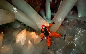
One of the world’s most spectacular geographical discoveries was the cave of giant crystals with its selenite crystals of a size never seen before. most of them measure six meters in length, with some of them reaching eleven meters. the temperature at this depth varies from 45°C to 50°C, while the percentage of humidity ranges from 90 to 100%, meaning that human beings cannot survive there for longer than two hours.
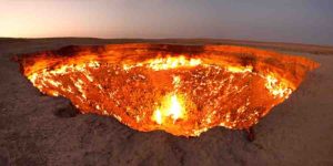
Door to Hell “Gate to Hell” – Turkmenistan
Door to Hell “Gate to Hell” – Turkmenistan
The “Door to Hell” is a natural gas field in Derweze, Turkmenistan, that collapsed into an underground cavern in 1971, becoming a natural gas crater. Geologists set it on fire to prevent the spread of methane gas, and it has been burning continuously since then. The diameter of the crater is 69 metres (226 ft), and its depth is 30 metres (98 ft).
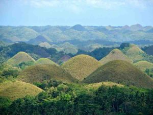
Chocolate Hills – Philippines
Chocolate Hills – Philippines
The Chocolate Hills (Cebuano: Mga Bungtod sa Tsokolate; Filipino: Mga Tsokolateng Burol) are a geological formation in the Bohol province of the Philippines. There are at least 1,260 hills but there may be as many as 1,776 hills spread over an area of more than 50 square kilometres (20 sq mi). They are covered in green grass that turns brown (like chocolate) during the dry season, hence the name.
The Chocolate Hills is a famous tourist attraction of Bohol. They are featured in the provincial flag and seal to symbolize the abundance of natural attractions in the province. They are in the Philippine Tourism Authority’s list of tourist destinations in the Philippines; they have been declared the country’s third National Geological Monument and proposed for inclusion in the UNESCO World Heritage List.
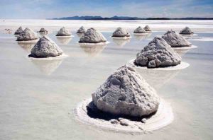
Salar de Uyuni – Bolivia
Salar de Uyuni – Bolivia
Salar de Uyuni (or Salar de Tunupa) is the world’s largest salt flat at 10 582 square kilometers (4 086 sq mi). It is in the Daniel Campos Province in Potosí in southwest Bolivia, near the crest of the Andes and is at an elevation of 3 656 meters (11 995 ft) above sea level.
The Salar was formed as a result of transformations between several prehistoric lakes. It is covered by a few meters of salt crust, which has an extraordinary flatness with the average elevation variations within one meter over the entire area of the Salar. The crust serves as a source of salt and covers a pool of brine, which is exceptionally rich in lithium. It contains 50 % to 70 % of the world’s known lithium reserves, which is in the process of being extracted. The large area, clear skies, and exceptional flatness of the surface make the Salar an ideal object for calibrating the altimeters of Earth observation satellites.
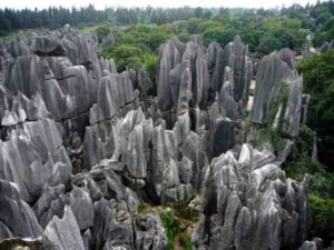
Stone Forest – China
Stone Forest – China
The Stone Forest or Shilin is a notable set of limestone formations about 500 km2 located in Shilin Yi Autonomous County, Yunnan Province, People’s Republic of China, near Shilin approximately 90 km (56 mi) from the provincial capital Kunming.
The tall rocks seem to arise from the ground in a manner somewhat reminiscent of stalagmites, or with many looking like petrified trees, thereby creating the illusion of a forest made of stone. Since 2007, two parts of the site, the Naigu Stone Forest (乃古石林) and Suogeyi Village (所各邑村), have been UNESCO World Heritage Sites as part of the South China Karst. The site is classified as a AAAAA-class tourist site.
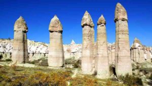
Fairy Chimneys – Turkey
Fairy Chimneys – Turkey
Cappadocia “Fairy Chimneys – Turkey” is a historical region in Central Anatolia, largely in the Nevşehir, Kayseri, Kırşehir, Aksaray, and Niğde Provinces in Turkey.
According to Herodotus, in the time of the Ionian Revolt (499 BC), the Cappadocians were reported as occupying a region from Mount Taurus to the vicinity of the Euxine (Black Sea). Cappadocia, in this sense, was bounded in the south by the chain of the Taurus Mountains that separate it from Cilicia, to the east by the upper Euphrates, to the north by Pontus, and to the west by Lycaonia and eastern Galatia.
The name, traditionally used in Christian sources throughout history, continues in use as an international tourism concept to define a region of exceptional natural wonders, in particular characterized by fairy chimneys and a unique historical and cultural heritage. is a historical region in Central Anatolia, largely in the Nevşehir, Kayseri, Kırşehir, Aksaray, and Niğde Provinces in Turkey.
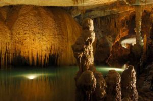
The Jeita Grotto – Lebanon
The Jeita Grotto – Lebanon<
The Jeita Grotto is a system of two separate, but interconnected, karstic limestone caves spanning an overall length of nearly 9 kilometres (5.6 mi). The caves are situated in the Nahr al-Kalb valley within the locality of Jeita, 18 kilometres (11 mi) north of the Lebanese capital Beirut. Though inhabited in prehistoric times, the lower cave was not rediscovered until 1836 by Reverend William Thomson; it can only be visited by boat since it channels an underground river that provides fresh drinking water to more than a million Lebanese.
In 1958, Lebanese speleologists discovered the upper galleries 60 metres (200 ft) above the lower cave which have been accommodated with an access tunnel and a series of walkways to enable tourists safe access without disturbing the natural landscape. The upper galleries house the world’s largest known stalactite. The galleries are composed of a series of chambers the largest of which peaks at a height of 12 metres (39 ft).
Aside from being a Lebanese national symbol and a top tourist destination, the Jeita grotto plays an important social, economic and cultural role in the country. It was one of top 14 finalists in the New 7 Wonders of Nature competition.
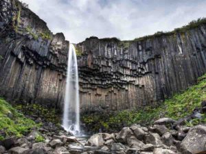
Skaftafell – Iceland
Skaftafell – Iceland
Skaftafell is a preservation area in Öræfi, southeast Iceland. It used to be a manor farm and a national park, but has been a part of Vatnajökull National Park since its establishment in 2008.
Skaftafell National Park was a national park, situated between Kirkjubæjarklaustur, typically referred to as Klaustur, and Höfn in the south of Iceland. On 7 June 2008, it became a part of the larger Vatnajökull National Park.
It was founded on September 15, 1967, and enlarged twice afterwards. Before its inclusion into Vatnajökull National Park, it measured about 4807 km2 (2884 mi2), making it Iceland’s second largest national park. It contains the valley Morsárdalur, the mountain Kristínartindar and the glacier Skaftafellsjökull (a spur of the Vatnajökull ice cap).
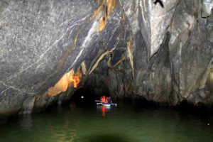
Puerto Princesa Underground River – Philippines
Puerto Princesa Underground River – Philippines
The Puerto Princesa Subterranean River National Park is a protected area of the Philippines located about 80 kilometres (50 mi) north of the city centre of Puerto Princesa, Palawan, and which contains the Puerto Princesa Underground River.
The park is located in the Saint Paul Mountain Range on the western coast of the island, and has been managed by the City Government of Puerto Princesa since 1992.
It was listed as a UNESCO World Heritage Site in 1999, and voted as a New7Wonders of Nature in 2012. It also became a Ramsar Wetland Site in 2012.
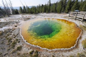
Yellowstone
Yellowstone National Park
Yellowstone National Park is a national park located in the U.S. states of Wyoming, Montana, and Idaho. It was established by the U.S. Congress and signed into law by President Ulysses S. Grant on March 1, 1872. Yellowstone was the first national park in the U.S. and is also widely held to be the first national park in the world. The park is known for its wildlife and its many geothermal features, especially Old Faithful geyser, one of its most popular features. It has many types of ecosystems, but the subalpine forest is the most abundant. It is part of the South Central Rockies forests ecoregion.
Native Americans have lived in the Yellowstone region for at least 11,000 years. Aside from visits by mountain men during the early-to-mid-19th century, organized exploration did not begin until the late 1860s. Management and control of the park originally fell under the jurisdiction of the Secretary of the Interior, the first being Columbus Delano. However, the U.S. Army was subsequently commissioned to oversee management of Yellowstone for a 30-year period between 1886 and 1916. In 1917, administration of the park was transferred to the National Park Service, which had been created the previous year. Hundreds of structures have been built and are protected for their architectural and historical significance, and researchers have examined more than a thousand archaeological sites.
Arches National Park – Utah
Credit: Neal Herbert/National Park Service
Arches National Park is a United States National Park in eastern Utah. The park is adjacent to the Colorado River, 4 miles (6 km) north of Moab, Utah. It is home to over 2,000 natural sandstone arches, including the world-famous Delicate Arch, in addition to a variety of unique geological resources and formations. It contains the highest density of natural arches in the world.
The park consists of 76,679 acres (119.811 sq mi; 31,031 ha; 310.31 km2) of high desert located in the Colorado Plateau. Its highest elevation is 5,653 feet (1,723 m) at Elephant Butte, and its lowest elevation is 4,085 feet (1,245 m) at the visitor center. Forty-three arches are known to have collapsed since 1977. The park receives on average 10 inches (250 mm) of rain a year.
Administered by the National Park Service, the area was originally named a National Monument on April 12, 1929. It was redesignated as a National Park on November 12, 1971.
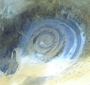
Richat Structure “Eye of the Sahara” – Mauritania
Richat Structure “Eye of the Sahara” – Mauritania. Credit: NASA/GSFC/MITI/ERSDAC/JAROS, and U.S./Japan ASTER Science Team
The Richat Structure, also known as the Eye of the Sahara and Guelb er Richat, is a prominent circular feature in the Sahara near Ouadane, west–central Mauritania.
The Richat Structure is a deeply eroded, slightly elliptical dome with a diameter of 40 kilometres (25 mi). The sedimentary rock exposed in this dome ranges in age from Late Proterozoic within the center of the dome to Ordovician sandstone around its edges. The sedimentary rocks comprising this structure dip outward at 10–20°. Differential erosion of resistant layers of quartzite has created high-relief circular cuestas. Its center consists of a siliceous breccia covering an area that is at least 30 kilometres (19 mi) in diameter.
Eisriesenwelt “World of Ice Giants” – Austria
Eisriesenwelt “World of Ice Giants” – Austria
The Eisriesenwelt (German for “World of the Ice Giants”) is a natural limestone and ice cave located in Werfen, Austria, about 40 km south of Salzburg. The cave is inside the Hochkogel mountain in the Tennengebirge section of the Alps. It is the largest ice cave in the world, extending more than 42 km and visited by about 200,000 tourists every year.
The Tennengebirge mountains were formed during the late Tertiary period, during the Würm glaciation period of the Pleistocene. The mountain range, one of the massifs in the Austrian Alps, is the largest karst plateau in the Salzburger Alps, and the Eisriesenwelt is located at the rim of this plateau. Although the cave has a length of 42 km, only the first kilometer, the area that tourists are allowed to visit, is covered in ice. The rest of the cave is formed of limestone.
Eisriesenwelt was formed by the Salzach river, which eroded passageways into the mountain. The ice formations in the cave were formed by thawing snow which drained into the cave and froze during winter.
Since the entrance to the caves is open year-round, chilly winter winds blow into the cave and freeze the snow inside. In summer, a cold wind from inside the cave blows toward the entrance and prevents the formations from melting.
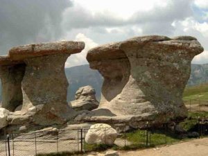
Babele – Romania
Babele – Romaniaurned Rock) challet.
Babele (meaning The old women) is a name for an area on the Bucegi Mountains plateau in Romania, within the Southern Carpathians.
Babele is one of the most popular tourist destinations in the country. The name comes from some mushroom shaped rock formations, the result of erosion and varying hardness of the rock layers.
The Bucegi Sphinx is another rock formation in the same area, named for its sphinx-like appearance.
The Babele chalet is accessible either by cable car from Buşteni or by road. It can also be reached by foot, coming from Buşteni through Valea Jepilor (Juniper Valley), or from the crest of Bucegi Mountains, from the Piatra Arsă (The Burned Rock) challet.
The Wave – Arizona
The Wave – Arizona
The Wave is a sandstone rock formation located in Arizona, United States near its northern border with Utah. The formation is situated on the slopes of the Coyote Buttes in the Paria Canyon-Vermilion Cliffs Wilderness of the Colorado Plateau. The area is administered by the Bureau of Land Management (BLM) at the Grand Staircase-Escalante National Monument visitor center in Kanab, Utah.
The formation is well-known among hikers and photographers for its colorful, undulating forms and the difficult hike required to reach it. Due to the fragile nature of the formation and the large number of people wishing to visit it, a daily lottery system is used to dispense only ten next-day permits in person at the Kanab visitor center. Additionally, ten online permits for each date are available four months in advance of a planned trip. A map and information about the hike are supplied to those who have obtained permits.
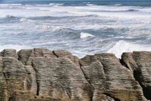
Punakaiki Pancake Rocks and Blowholes – New Zealand
Punakaiki Pancake Rocks and Blowholes – New Zealand
Punakaiki is a small community on the West Coast of the South Island of New Zealand, between Westport and Greymouth. The community lies on the edge of the Paparoa National Park.
The Pancake Rocks are a very popular tourist destination at Dolomite Point south of the main village. The Pancake Rocks are a heavily eroded limestone area where the sea bursts through several vertical blowholes during high tides. Together with the ‘pancake’-layering of the limestone (created by immense pressure on alternating hard and soft layers of marine creatures and plant sediments), these form the main attraction of the area.
The Pancake Rocks are presently explorable by a number of walkways winding through the rock formations, parts of these wheelchair-accessible and others carved into stairways up and down the rock faces. State Highway 6, the only through road on the West Coast, passes through the town.
Fingal’s Cave – Scotland
Fingal’s Cave – Scotland
Fingal’s Cave is a sea cave on the uninhabited island of Staffa, in the Inner Hebrides of Scotland, known for its natural acoustics. The National Trust for Scotland owns the cave as part of a National Nature Reserve. It became known as Fingal’s Cave after the eponymous hero of an epic poem by 18th-century Scots poet-historian James Macpherson.
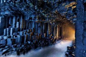
This is the Giant’s Causeway. Credit: University of Liverpool
A new study by geoscientists at the University of Liverpool has identified the temperature at which cooling magma cracks to form geometric columns such as those found at the Giant’s Causeway in Northern Ireland and Devils Postpile in the USA.
Geometric columns occur in many types of volcanic rocks and form as the rock cools and contracts, resulting in a regular array of polygonal prisms or columns.
Columnar joints are amongst the most amazing geological features on Earth and in many areas, including the Giant’s Causeway, they have inspired mythologies and legends.
One of the most enduring and intriguing questions facing geologists is the temperature at which cooling magma forms these columnar joints.
Liverpool geoscientists undertook a research study to find out how hot the rocks were when they cracked open to form these spectacular stepping stones.
In a paper published in Nature Communications, researchers and students at the University’s School of Environmental Sciences designed a new type of experiment to show how as magma cools, it contracts and accumulates stress, until it cracks. The study was performed on basaltic columns from Eyjafjallajökull volcano, Iceland.
They designed a novel apparatus to permit cooling lava, gripped in a press, to contract and crack to form a column. These new experiments demonstrated that the rocks fracture when they cool about 90 to 140?C below the temperature at which magma crystallises into a rock, which is about 980?C for basalts.
This means that columnar joints exposed in basaltic rocks, as observed at the Giant’s Causeway and Devils Postpile (USA) amongst others, were formed around 840-890 ?C.
Yan Lavallée, Liverpool Professor of Volcanology who headed the research, said: “The temperature at which magma cools to form these columnar joints is a question that has fascinated the world of geology for a very long time. We have been wanting to know whether the temperature of the lava that causes the fractures was hot, warm or cold.
“I have spent over a decade pondering how to address this question and construct the right experiment to find the answer to this question. Now, with this study, we have found that the answer is hot, but after it solidified.”
Dr Anthony Lamur, for whom this work formed part of his doctoral study, added: “These experiments were technically very challenging, but they clearly demonstrate the power and significance of thermal contraction on the evolution of cooling rocks and the development of fractures.”
Dr Jackie Kendrick, a post-doctoral researcher in the Liverpool group said: “Knowing the point at which cooling magma fractures is critical, as -beyond leading to the incision of this stunning geometrical feature- it initiates fluid circulation in the fracture network. Fluid flow controls heat transfer in volcanic systems, which can be harnessed for geothermal energy production. So the findings have tremendous applications for both volcanology and geothermal research.”
Understanding how cooling magma and rocks contract and fracture is central to understand the stability of volcanic constructs as well as how heat is transferred in the Earth.
Professor Lavallée added: “The findings shed light on the enigmatic observations of coolant loss made by Icelandic engineers as they drilled into hot volcanic rocks in excess of 800?C; the loss of coolant in this environment was not anticipated, but our study suggests that substantial contraction of such hot rocks would have opened wide fractures that drained away the cooling slurry from the borehole.
“Now that we know this, we can revisit our drilling strategy and further our quest for the new development of magma energy sources.”
Reference:
Anthony Lamur, Yan Lavallée, Fiona E. Iddon, Adrian J. Hornby, Jackie E. Kendrick, Felix W. von Aulock, Fabian B. Wadsworth. Disclosing the temperature of columnar jointing in lavas. Nature Communications, 2018; 9 (1) DOI: 10.1038/s41467-018-03842-4
A new study found that the process of mountain erosion can be a source of new carbon dioxide gas that can release it back into the atmosphere far faster than it’s being absorbed into newly exposed rock. The researchers conducted fieldwork in one of the most erosion-prone mountain chains in the world — the central range of Taiwan (above). Credit: Image by Robert Hilton, Durham University
Scientists have long known that steep mountain ranges can draw carbon dioxide (CO2) out of the atmosphere — as erosion exposes new rock, it also starts a chemical reaction between minerals on hill slopes and CO2 in the air, “weathering” the rock and using CO2 to produce carbonate minerals like calcite.
A new study led by researchers from the Woods Hole Oceanographic Institution (WHOI), however, has turned this idea on its head. In paper released on April 12th in the journal Science, the scientists announced that the erosion process can also be a source of new CO2 gas, and can release it back into the atmosphere far faster than it’s being absorbed into newly-exposed rock.
“This goes against a long-standing hypothesis that more mountains mean more erosion and weathering, which means an added reduction of CO2. It turns out it’s much more complicated than that,” says Jordon Hemingway, a postdoctoral fellow at Harvard University and lead author on the paper.
The source of this extra CO2 isn’t entirely geological. Instead, it’s the byproduct of tiny microbes in mountain soils that “eat” ancient sources of organic carbon that are trapped in the rock. As the microbes metabolize these minerals, they spew out carbon dioxide.
The researchers came to this realization after studying one of the most erosion-prone mountain chains in the world — the central range of Taiwan. This steep-sided range is pummeled by more than three major typhoons each year, each of which mechanically erode the soil and rock through heavy rains and winds.
Hemingway and his colleagues examined samples of soil, bedrock, and river sediments from the central range, looking for telltale signs of organic carbon in the rock. What they found there surprised them.
“At the very bottom of the soil profile, you have basically unweathered rock. As soon as you hit the base of the soil, layer, though, you see rock that’s loose but not yet fully broken down, and at this point the organic carbon present in the bedrock seems to disappear entirely,” notes Hemingway. At that point in the soil, the team also noticed an increase in lipids that are known to come from bacteria, he adds.
“We don’t yet know exactly which bacteria are doing this — that would require genomics, metagenomics, and other microbiological tools that we didn’t use in this study. But that’s the next step for this research,” says WHOI marine geochemist Valier Galy, senior author and Hemingway’s advisor in the MIT/WHOI Joint Program.
The group is quick to note that the total level of CO2 released by these microbes isn’t severe enough to have any immediate impact on climate change — instead, these processes take place on geologic timescales. The WHOI team’s research may lead to a better understanding of how mountain-based (or “lithospheric”) carbon cycles actually work, which could help generate clues to how CO2 has been regulated since the Earth itself formed.
“Looking backwards, we’re most interested in how these processes managed to keep the levels of CO2 in the atmosphere more or less stable over millions of years. It allowed Earth to have the climate and conditions it’s had — one that has promoted the development of complex life forms,” says Hemingway. “Throughout our Earth’s history, CO2 has wobbled over time, but has remained in that stable zone. This is just an update of the mechanism of geological processes that allows that to happen,” he adds.
Reference:
Jordon D. Hemingway, Robert G. Hilton, Niels Hovius, Timothy I. Eglinton, Negar Haghipour, Lukas Wacker, Meng-Chiang Chen, Valier V. Galy. Microbial oxidation of lithospheric organic carbon in rapidly eroding tropical mountain soils. Science, 2018; 360 (6385): 209 DOI: 10.1126/science.aao6463
When magma can’t find its way to the surface of the Earth, it pools in magma chambers (yellow oval). The temperature and pressure in this reservoir make the magma split into two separate liquids, one of which is very rich in iron. As this liquid cools, it forms iron ore deposits (in black). Credit: Mark A. Garlick
Geologists have discovered that some magmas split into two separate liquids, one of which is very rich in iron. Their findings can help to discover new iron ore deposits for mining.
Iron ore is mined in about 50 countries, with Australia, Brazil and China as the largest producers. It is mostly used to produce the steel objects that are all around us — from paper clips to kitchen appliances and the supporting beams in skyscrapers.
Most iron ore deposits are found in sedimentary rocks. Others are mined in volcanic complexes such as El Laco in Chile and Kiruna in Sweden. These iron ore deposits, called Kiruna-type deposits, account for about 10% of the global production of iron, yet nobody knows how they are formed.
In Nature Communications, an international team of researchers from institutions including KU Leuven, Leibniz University Hannover, and ULiège present the first evidence that these iron ore deposits are formed when magma splits into two separate liquids.
“Previous studies have always focused on the texture or the composition of natural rocks. We were the first to actually reproduce magmas in the lab such as the ones found in El Laco,” says last author Olivier Namur from the Department of Earth and Environmental Sciences at KU Leuven, Belgium.
“We wanted to reproduce the conditions found in magma chambers, where molten rock accumulates when it cannot rise to the surface of the Earth. This is also where the iron ore deposits beneath volcanoes are formed, so reproducing the temperature and pressure of the magma chambers seemed well worth examining.”
“That’s why we produced a mixture of iron-rich ore samples and typical lavas surrounding Kiruna-type deposits. This created a bulk magma composition that we believe exists in the deep magma chamber beneath volcanoes. We placed the mixture in a furnace and raised the temperature to 1,000-1,040°C. We also increased the pressure to about 1000 times the atmospheric pressure of Earth. These are the conditions of a magma chamber.”
“We were surprised to find that, under these conditions, the magma split into two separate liquids. This process is known as immiscibility. Just think of what happens when oil spills into the ocean: the water becomes streaked with oil because oil and water cannot mix.”
“One of these liquids contained a lot of silica, whereas the other was extremely rich in iron — up to 40% — and phosphorus. When this iron-rich liquid starts to cool down, you get iron-phosphorus Kiruna-type ore deposits.”
“This is the first evidence that immiscibility is key to the formation of iron ore deposits such as the ones mined in El Laco. If we’re right, these findings may help to find new iron ore deposits. This is necessary to keep up with the global demand for iron: recycling alone is not enough yet. And if you want to know where to look for iron ore, you have the understand how the deposits are formed.”
Reference:
Tong Hou, Bernard Charlier, François Holtz, Ilya Veksler, Zhaochong Zhang, Rainer Thomas, Olivier Namur. Immiscible hydrous Fe–Ca–P melt and the origin of iron oxide-apatite ore deposits. Nature Communications, 2018; 9 (1) DOI: 10.1038/s41467-018-03761-4
Lake Urmia (LU), its water level over time, and the survey area of the four satellites are shown, along with a topographic map of Iran and a sketch of the Lake Urmia Causeway. Credit: Scientific Reports
Scientists at Tokyo Institute of Technology (Tokyo Tech) used synthetic-aperture radar data from four different satellites, combined with statistical methods, to determine the structural deformation patterns of the largest bridge in Iran.
The importance of roads and bridges for humans both during ancient and contemporary times is clearly evident. The structural health and integrity of such large structures are, however, not nearly as evident, mainly because structures tend to deteriorate over a long time. Determining the amount of deformation a structure has undergone (and how much it will undergo in the future) is crucial for ensuring the safety of the people in or near that structure and for minimizing repair costs and potential damage.
One large structure that has raised concerns over the last decade is the Lake Urmia Causeway (LUC), a series of roads and a bridge that go over Lake Urmia, located in northwest Iran (see Figure 1). Iran, known as an arid to semi-arid area, has serious problems with land subsidence due to excessive underground water extraction. Thus, Dr. Sadra Karimzadeh who realized the problem of the LUC and joined a team of scientists at Tokyo Tech, led by Professor Masashi Matsuoka, analyzed the recent deformation patterns that the LUC underwent from 2004 to 2017, using datasets obtained from four satellites equipped with synthetic-aperture radars (see Figure 2). As expected, these datasets required sophisticated mathematical and statistical analyses before the deformation rates (related to the natural settlement of the east embankment and the artificial uplift at the beginning of the west embankment) could be more accurately determined.
Using the small baseline subset (SBAS) technique on the satellites’ data, the uncertainty in the obtained vertical displacement rates of the LUC was reduced. The research team also performed a field survey of the lake in 2017 to observe the physical conditions of the LUC and to investigate the most likely causes of the accelerated deformation affecting the structure.
In order to verify their assumptions on the causes of the accelerated deformation, the team conducted a principal component analysis (PCA) on the data and then used a hydro-thermal model to compare results. PCA is a technique that takes multi-dimensional data as an input and flattens them into usually two or three dimensions (referred to as the “principal components” or “PCs”), which can be then used to reveal new and valuable comparative information. Only three principal components accounted for almost all the variability in the data, with the first one (the most significant one) revealing an overall downwards trend in the structure caused by soil consolidation, and the second and third ones being associated to both seasonal changes and human activity affecting the lake (see Figure 3). The team made a prediction as to how much deformation can be expected to occur in the following 365 days.
Dr. Sadra Karimzadeh said, “The results of space-based monitoring of critical structures is quite useful in developing countries. It must be continuously utilized at affordable costs.”
With this study, the research team demonstrated how PCA can be effectively employed to accommodate data from different datasets over multiple timescales. The combination of the aforementioned techniques prove how data from current and previous satellite missions can be used as an efficient mechanism to determine the current and future health of structures such that preventive actions can be taken to minimize potential damage and reduce costs.
Reference:
Sadra Karimzadeh et al, Spatiotemporal deformation patterns of the Lake Urmia Causeway as characterized by multisensor InSAR analysis, Scientific Reports (2018). DOI: 10.1038/s41598-018-23650-6
Representative Image: The tectonic plates underlying the continents and oceans. Credit: USGS
The cyclic strengthening and weakening of ocean tides over tens of millions of years is likely linked to another, longer cycle: the formation of Earth’s supercontinents every 400 to 600 million years, according a new study. The new findings have implications for the formation of our planet, its climate and the evolution of life on Earth, according to the study’s authors. The new research suggests long-term changes in tidal energy, which control the strength of the ocean’s waves, are part of a super-tidal cycle dictated by the movement of tectonic plates.
When tectonic plates slide, sink and shift the Earth’s continents to form large landmasses, or supercontinents, ocean basins open and close in tandem. As these basins change shape, they can strike forms that amplify and intensify their tides.
In the new study, tidal simulations projected hundreds of millions of years into the future suggest the Earth is now in the nascent stage of a tidal energy maximum, where strong tides will persist for roughly 20 million years. The oceans will go through several tidal cycles as the next supercontintent forms over the next 250 million years. Eventually, the tides will grow much weaker, just as they did during the two most recent supercontinents: Pangaea and Rodinia, according to the new study published in Geophysical Research Letters, a journal of the American Geophysical Union.
Scientists were aware tidal energy varied in the distant past, but the new study suggests there is a super-tidal cycle occurring over geologic timescales and linked to tectonic movement.
“Our simulations suggest that the tides are, at the moment, abnormally large,” said oceanographer Mattias Green from Bangor University’s School of Ocean Sciences in Menai Bridge in the United Kingdom and lead author of the new study. “And that really was our motivating question: If the tides were weak up until 200 million years ago, and they’ve since shot up and become very energetic over the past two million years, what will happen if we move millions of years into the future?”
Tidal strength is linked to life on Earth and understanding the ocean’s cyclic progression stands to inform scientists’ understanding of evolutionary history, according to the study’s authors. In times of strong tidal energy, like today, strong waves stir the sea, creating the nutrient mixing needed to sustain ocean life. As Earth’s landmasses move slowly toward a supercontinent configuration, the planet’s ocean basins open, eventually forming one unbroken mass of water. Such a sea would have low tidal energy. Weak waves mean there is less nutrient mixing, which could create an oxygen-starved ocean floor largely devoid of life, much like a pool of stagnant water, according to the new study.
The existence of this cycle and its link to tectonic movement stands to inform many disciplines, from evolutionary biology to global nutrient cycling, according to geophysicist Dietmar Müller from the University of Sydney in Australia, who wasn’t involved in the new study.
“It probably doesn’t mean anything to humans now in our lifetime,” Muller said. “But it does enhance our understanding of interactions between plate tectonics, Earth’s climate system, its oceans, and even how the evolution of life is, at least to some extent, driven by this tidal process.”
Changing continents, ocean basins
Each of Earth’s continents ride atop huge slabs of rock known as tectonic plates. These plates shift over hundreds of millions of years, striking different continental configurations along the way.
Tectonic plates dictate the shape and arrangement of continents, but they also determine the shape of ocean basins. As the North American and Eurasian plates drift apart, the Atlantic Ocean between them widens, also changing its shape.
The change in shape of ocean basins causes a change in a property known as resonance. When a basin is resonant, energy from the gravitational attraction of the moon aligns with the length of the ocean basin, causing an amplification of tidal energy.
Green likens resonance to a child on a swing set. A swinging child only needs a small push from an adult, at the right timing, to keep the swing moving higher and higher. “You force it at the same frequency as the natural oscillation, and the same thing happens in the ocean,” he said.
A tectonic timeline
In the new study, scientists simulated the movement of Earth’s tectonic plates and changes in the resonance of ocean basins over millions of years.
The new research suggests the Atlantic Ocean is currently resonant, causing the ocean’s tides to approach maximum energy levels. Over the next 50 million years, tides in the North Atlantic and Pacific oceans will come closer to resonance and grow stronger. In that time, Asia will split, creating a new ocean basin, according to the study.
In 100 million years, the Indian Ocean, Pacific Ocean and a newly formed Pan-Asian Ocean will see higher resonance and stronger tides as well. Australia will move north to join the lower half of Asia, as all the continents slowly begin to coalesce into a single landmass in the northern hemisphere, according to the new study.
After 150 million years, tidal energy begins to decline as Earth’s landmasses form the next supercontinent and resonance declines. In 250 million years, the new supercontinent will have formed, bringing in an age of low resonance, leading to low tidal energy and a largely quiet sea, according to the new research.
The new study finds each tidal maximum lasts at most 50 million years and is not necessarily in phase with the supercontinent cycle.
Reference:
J. A. M. Green, J. L. Molloy, H. S. Davies, J. C. Duarte. Is there a tectonically driven super-tidal cycle? Geophysical Research Letters, 2018; DOI: 10.1002/2017GL076695
Ecological restoration of moths in the Cretaceous Burmese amber forest. Credit: Yang Dinghua
Pioneering new research has given an illuminating new insight into the metallic, iridescent colours found on the earliest known ancestors of moths and butterflies, which habited the earth almost 200 million years ago.
An international team of researchers, including Dr Tim Starkey from the University of Exeter, have discovered new evidence for colour in Mesozoic fossils.
The structural colours of the fossils studied resulted from light scattering by intricate microstructures, extending the evidence for these light-scattering structures in the insect fossil record by more than 130 million years.
The research team examined fossilised remains dating back 180 million years, with some specimens originating from the Jurassic Coast, only a short distance from Exeter.
Using powerful electron microscopes and using optical models, the team found microscopic ridges and grooves in the insect’s wing scales, similar to those seen in today’s moths. Models revealed these tiny features are photonic structures that would have produced metallic bronze to golden colour appearances in the insect wings.
The research is published in leading journal Science Advances on Wednesday, April 11 2018.
Insects have evolved an amazing range of photonic structures that can produce iridescence, metallic colours, and other flashy effects that are important for behaviour and ecological functions.
Dr Starkey, part of Exeter’s Physics and Astronomy department, said: “The structural colours exhibited by butterflies and moths have been a longstanding research interest in Exeter, and have helped us develop biologically-inspired optical technologies for the present day.
“However, in this study we’ve looked millions of years back in time to early origins of such colours in nature, to understand how and when the evolution of colours in these insects took place.”
The study was co-authored by palaeontologists Drs Maria McNamara and Luke McDonald from UCC, in Ireland. Dr McNamara added: “Remarkably, these fossils are among the oldest known representatives of butterflies and moths.
“We didn’t expect to find wing scales preserved, let alone microscopic structures that produce colour. This tells us that colour was an important driving force in shaping the evolution of wings even in the earliest ancestors of butterflies and moths.”
Dr McDonald, previously of the Natural Photonics group in Exeter, said; “Uniquely in this study, we show that impression fossils, i.e. wing prints, are equally as capable as compression fossils at preserving the structure of scales in sufficient detail to elucidate the moths’ 180 million year old colours.”
Reference:
Qingqing Zhang et al. Fossil scales illuminate the early evolution of lepidopterans and structural colours. Science Advances, 2018 DOI: 10.1126/sciadv.1700988
Female (top) and male (below) of the ostracod Cypideis salebrosa. Note the male shell is more elongated than that of the female. This is thought to reflect the need to accommodate the large male genitalia (highlighted in blue). A team of researchers studied this specimen and others in the collections of the Smithsonian’s National Museum of Natural History to better understand the role of sexual selection in extinction. Credit: M. João Fernandes Martins, Smithsonian
The lengths that some males go to attract a mate can pay off in the short-term. But according to a new study from scientists at the Smithsonian’s National Museum of Natural History (NMNH), extravagant investments in reproduction also have their costs.
By analyzing the fossils of thousands of ancient crustaceans, a team of scientists led by NMNH paleontologist Gene Hunt has found that devoting a lot of energy to the competition for mates may compromise species’ resilience to change and increase their risk of extinction. Hunt, NMNH postdoctoral fellow M. João Fernandes Martins, and collaborators at the College of William and Mary and the University of Southern Mississippi reported their findings April 11, 2018, in the journal Nature.
Many present-day species offer showy examples of sexual dimorphism — characteristic differences between males and females that usually help males attract and secure mates. The need to pass genes to future generations is so critical that in some species, males put a lot of energy into generating these sex-specific features — a peacock’s elaborate tail feathers or an elephant seal’s massive, territory-defending body size, for example.
Hunt says some scientists have proposed that the energy animals devote to developing these traits may limit the resources they have available for survival, particularly when something in their environment changes. That would put species with strong sexual dimorphism at greater risk of extinction. But it’s been difficult to determine how sexual dimorphism has impacted species survival because in most cases, scientists can’t tell from a fossil whether an animal was male or female.
Ostracods, tiny crustaceans that have been on the planet for nearly 500 million years, are an exception. The shrimp-like creatures, which live inside hinged shells smaller than a poppy seed, have distinctive sex-specific shapes that are preserved in the fossil record. Animals with elongated bodies and shells are males, whereas females are usually smaller with a squatter shape. An elongated shell shape accommodates the male’s large sex organs — with larger organs presumably producing more sperm and improving individuals’ opportunities for reproductive success, Hunt explains.
Hunt and his colleagues drew on large collections of ostracod fossils from the Smithsonian’s National Museum of Natural History, the University of Southern Mississippi, and Louisiana State University, as well as additional fossils they collected themselves, to investigate whether species in which this male/female distinction was most prominent had been more vulnerable than others to changes in their environments.
The team pored over thousands of the specimens, noting when different species had lived based on the geological layer from which they were collected and assessing the shapes and sizes of more than 6,000 individuals. Their final analysis included 93 different species of ostracods that lived during the late Cretaceous period, between about 85 and 65 million years ago.
Some species appeared over and over again in the fossil collections, and the team found that some had lived throughout almost the entire 20-million-year span. Others lasted just a few hundred thousand years. And the size and shape of the males did appear to have been a significant factor in species’ longevity. “We showed that when males are larger and more elongated than the females, those species tend to not last as long in the fossil record. They have a higher risk of extinction,” Hunt says.
If the same holds true for other species, Hunt says, conservation biologists may want to take sexual dimorphism into account when assessing species’ vulnerability to current environmental threats. “If devoting so much energy to reproduction made it harder for species in the past to adapt to changing circumstances, perhaps that same should apply to species we’re concerned about conserving in the present day,” he says.
Funding for this study was provided by the National Science Foundation and the Smithsonian’s National Museum of Natural History.
Reference:
Maria João Fernandes Martins, T. Markham Puckett, Rowan Lockwood, John P. Swaddle & Gene Hunt. High male sexual investment as a driver of extinction in fossil ostracods. Nature, 2018 DOI: 10.1038/s41586-018-0020-7
Teeth from the Gadoufaoua deposit (Niger). The scale bar represents 2 cm. From left to right: teeth of a giant crocodile, Sarcosuchus imperator, a spinosaurid, a non-spinosaurid theropod (abelisaurid or carcharodontosaurid), a pterosaur, a hadrosaurid (a herbivorous dinosaur), a pycnodont (fish), and a small crocodylomorph. Credit: Auguste Hassler / LGL-TPE / CNRS-ENS de Lyon-Université Lyon 1
By studying calcium in fossil remains in deposits in Morocco and Niger, researchers have been able to reconstruct the food chains of the past, thus explaining how so many predators could coexist in the dinosaurs’ time. This study, conducted by the Laboratoire de géologie de Lyon: Terre, planètes et environnement (CNRS/ENS de Lyon/Claude Bernard Lyon 1 University), in partnership with the Centre for Research on Palaeobiodiversity and Palaeoenvironments (CNRS/French National Museum of Natural History/Sorbonne University), is published on April 11, 2018 in the Proceedings of the Royal Society of London B.
A hundred million years ago, in North Africa, terrestrial ecosystems were dominated by large predators—giant theropod dinosaurs, large crocodiles—with comparatively few herbivores. How were so many carnivores able to coexist?
To understand this, French researchers have studied fossils in the Gadoufaoua deposits in Niger (dating from 120 million years ago) and the Kem Kem Beds in Morocco (dating from 100 million years ago). These two sites are characterized by an overabundance of predators compared to the herbivorous dinosaurs found in the locality. More specifically, the researchers measured the proportions of different calcium isotopes in the fossilized remains (tooth enamel and fish scales).
Among vertebrates, calcium is almost exclusively derived from food. By comparing the isotopic composition of potential prey (fish, herbivores) with that of the carnivores’ teeth, it is thus possible to retrace the diet of those carnivores.
The data obtained show similar food preferences at the two deposits: some large carnivorous dinosaurs (abelisaurids and carcharodontosaurids) preferred to hunt terrestrial prey such as herbivorous dinosaurs, while others (the spinosaurids) were piscivorous (fish-eating). The giant crocodile-like Sarcosuchus had a diet somewhere in between, made up of both terrestrial and aquatic prey. Thus, the different predators avoided competition by subtly sharing food resources.
Some exceptional fossils, presenting traces of feeding marks and stomach content, had already provided clues about the diet of dinosaurs. Yet such evidence remains rare. The advantage of the calcium isotope method is that it produces a global panorama of feeding habits at the ecosystem scale. It thus opens avenues for further study of the food chains of the past.
This study received support from the Labex Institut des origines de Lyon, the Institut national des sciences de l’Univers, part of the CNRS (through the Diunis project), and the Jurassic Foundation.
Reference:
A. Hassler et al. Calcium isotopes offer clues on resource partitioning among Cretaceous predatory dinosaurs, Proceedings of the Royal Society B: Biological Sciences (2018). DOI: 10.1098/rspb.2018.0197
Note: The above post is reprinted from materials provided by CNRS.